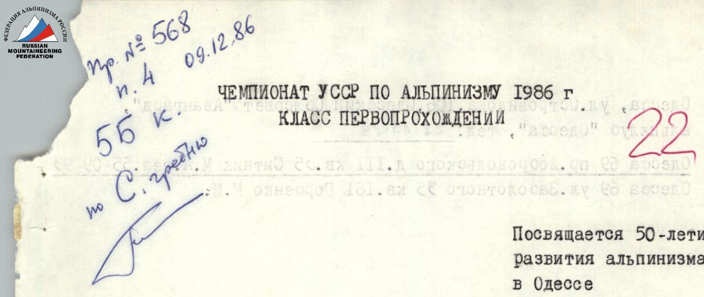
Dedicated to the 50th anniversary of alpinism development in Odessa
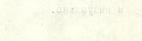
PEAK 4810 (ODESSAN ALPINISTS), TURKESTAN RANGE FROM NORTH-WEST
REPORT ON THE ASCENT BY RS "AVANGARD" TEAM, A/C "ODESSA"
1580 m, 2000 m, (Y–Yl) 980, 53°, 68/3 cm, 2/1 m, 83/3 cm, 20.49, 26 cm 8-10/7-86
Team Leader Sитник M.A. Coach Горбенко M.M. Старицкий P.S. — MS Серенков P.S. — MS Тодоров V.S. — CMS
 Odessa,
Ostrovidov Str., 106, Odessa Regional Council "Avangard", alpcclub "Odessa",
phone 22-85-79.
Odessa 69, Dobrovolsky Ave., bld. III, apt. 35, Ситник M.A., phone 55-09-93.
Odessa 69, Zabolotnogo Str., 35, apt. 161, Горбенко M.M.
Odessa,
Ostrovidov Str., 106, Odessa Regional Council "Avangard", alpcclub "Odessa",
phone 22-85-79.
Odessa 69, Dobrovolsky Ave., bld. III, apt. 35, Ситник M.A., phone 55-09-93.
Odessa 69, Zabolotnogo Str., 35, apt. 161, Горбенко M.M.
The heights marked in the report were determined using a map, aerial photography, and visually.
Photo 0+2. Right wall profile. Taken on July 12, 1986 at 15:30. "HELIOS-44" lens from a height of 4000 m, distance 1000 m.
Team's Tactical Actions
The ascent was carried out in strict accordance with the tactical plan approved by the coaching council. The rope teams M. Sitnik – P. Staritskiy and P. Serenkov – V. Todorov worked mostly independently, interacting only when using the pitons and chocks left by the first rope team. To speed up the passage, fixed ropes were organized on sections R4–R5 and R6–R11. The use of fixed ropes was partially due to the following tactical technique:
- after the group reached the next overnight stay location, one rope team performed bivouac work;
- the other rope team processed the route above.
This made it easier to climb complex sections on cold rocks in the morning and served as a warm-up before difficult climbing.
On sections R0–R3, the rope team P. Serenkov – V. Todorov worked first, with the leader changing every 40 m. On sections R3–R14, the route was laid by the rope team M. Sitnik – P. Staritskiy.
The first climbers in the rope teams were secured by:
- two UIAA ropes;
- when moving along fixed ropes, additional belay was used.
There were no falls or injuries during the ascent.
The wall on section R9–R10 was a problematic part of the route. To pass it, the entire arsenal of rock climbing techniques was used, including the use of skyhooks as artificial support points (ITOs) on four occasions.
Communication with observers and the base was regularly carried out according to the schedule using "Lastochka" radios.
To ensure daily rest, the group paid great attention to preparing overnight stay sites, spending 3 hours on laying out and arranging them. Hot food and drinks helped restore strength for the next morning's work.
A good set of chocks and rock pitons allowed for quick creation of belay points or ITOs. On sections R4–R13, the first climber worked in galoshes.
The most dangerous part of the route was the snow-ice couloir, which was climbed during the night ascent using headlamps.
The tactical actions mentioned are reflected in the graphs, diagrams, and photographs.
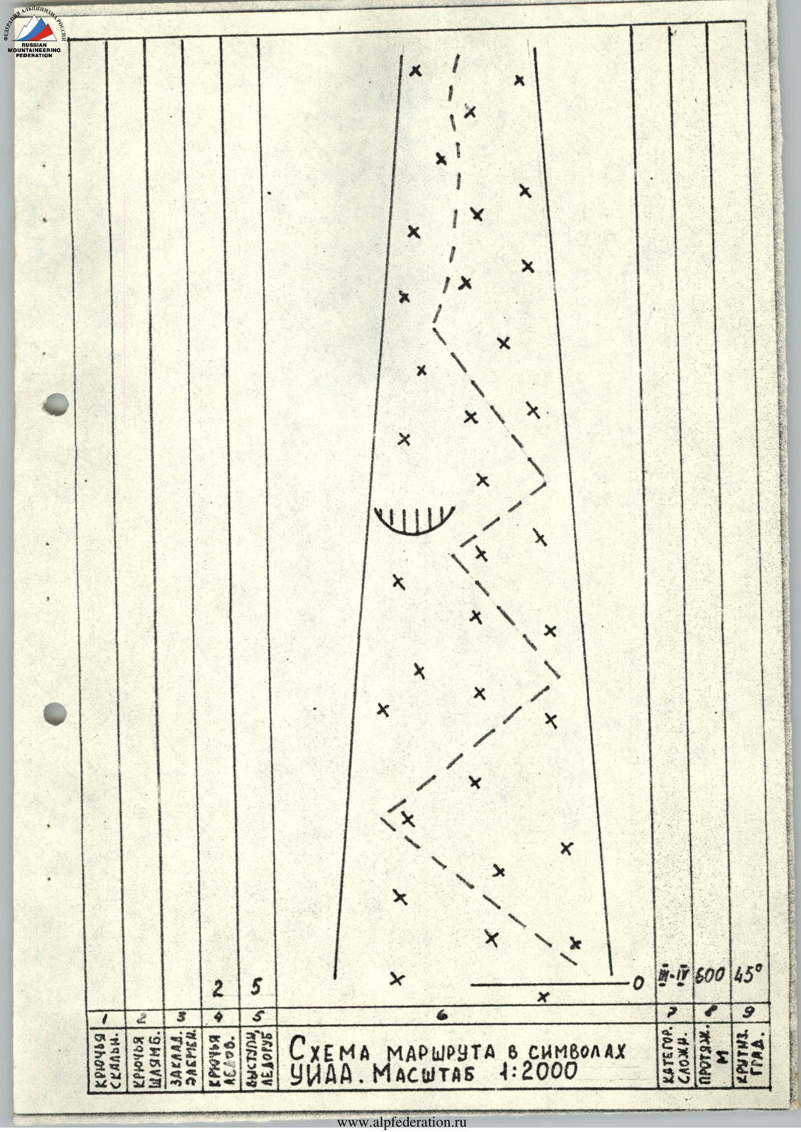
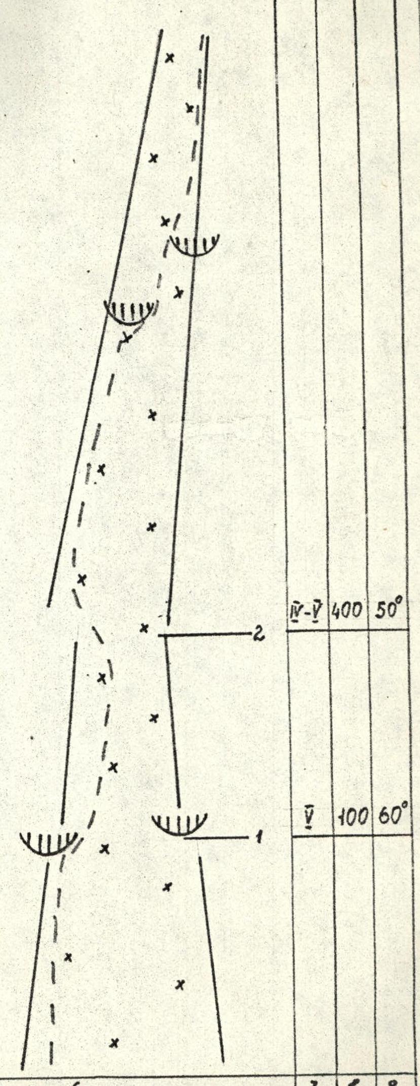
Route diagram in UIAA symbolism. Scale 1:2000
Conventional symbols:
- Rock pitons
- Pitons (bolts)
- Chocks
- ITO
- Ice screws
- Protrusions
- Кат. сл. — Category of difficulty
- Протяж., м — Length in meters
- Крутизна, ° — Steepness in degrees
Data on equipment and section parameters
| Rock pitons | Pitons (bolts) | Chocks | ITO | Ice screws | Protrusions | |
|---|---|---|---|---|---|---|
| For sections R0–R1 (presumably) | 10 | 1 | 7 | 1 | 11 | 6 |
| For sections R3–R9 (presumably) | 4 | 4 | 10 | 1 | 8 | 6 |
| Category of difficulty | Length, m | Steepness, ° | |
|---|---|---|---|
| For sections R0–R1 (presumably) | IV | 400 | 50 |
| V | 100 | 60 | |
| For sections R3–R9 (presumably) | IV | 40 | 70 |
| V | 40 | 60 | |
| VI | 80 | 50 | |
| IV | 40 | 60 | |
| V | 200 | 65 | |
| IV | 40 | 50 | |
| For sections R9–R14 (presumably) | V | 150 | 30 |
| IV | 150 | 50 | |
| V | 40 | 60 | |
| V | 40 | 70 | |
| VI | 80 | 80 |
General data and additional information:
- Equipment (total): Rock pitons: 88/3; Pitons (bolts): 2/1; Chocks: 83/3; ITO: 20
- Total climbing time: 25.5 hours
- Equipment (by sections):
- 2 rock pitons, 3 pitons (bolts), 5 chocks
- 11 rock pitons, 13 pitons (bolts)
- 2 rock pitons, 5 pitons (bolts)
- 6 rock pitons, 4 pitons (bolts)
- 8/3 rock pitons, 2/4 pitons (bolts), 14/3 chocks
- Climbing time for sections R9–R14: 10 hours
- Equipment used on sections R9–R14: Rock pitons and chocks: 85; Pitons (bolts): 2.

Route description by sections
The route passed through a steep northwestern ice-snow couloir (sections R0–R3) with a length of 1100 m, then along the 900 m northern wall of Peak 4810 m (sections R3–R14).
Sections R0–R3: The first 100 m of the couloir have a steepness of about 30°, dense snow, simultaneous movement. As you ascend, the steepness increases, ice appears more frequently, and in the steepest places, belay is done through an ice axe, protrusions, and sometimes ice screws. The passage through the narrow ice "throat" on section R1–R2 is the most difficult. Further on, it becomes more frequent to overcome icy rock outcrops, using rock pitons for belay. The exit to the saddle is done along a steep firn slope. Possible overnight stay location.
Sections R3–R8: Steep counterfort. From the saddle, 18 m upwards along snow-covered and icy rocks (slabs), traverse right upwards under a cornice. The cornice is overcome by complex climbing through a crack leading to an icy groove. Climb up the groove to the crest of the counterfort. Overnight stay site on the crest, snow is present. From the overnight stay site, climb 80 m up the right wall of the counterfort, vertical cracks; then move to the left wall along a smooth slab and upwards to a steep, barely fissured wall.
Sections R8–R12: The counterfort abuts the wall. Along interrupted ledges, 10 m to the right, and 30 m up a chimney. Here, a piton (bolt) is hammered in to organize a belay point (there are no cracks). After the chimney, the steepness increases sharply, climbing becomes extremely difficult. Small cornices are often encountered and are bypassed on the left. Skyhooks are used four times to overcome smooth sections, and 1 piton (bolt) is hammered in for belay. Vertical cracks formed by splits and "stuck" rocks prevail. Rocks are solid. There are no ledges for organizing belay points. After 80 m, traverse right and exit into an inconvenient internal corner (the right wall overhangs, the left wall is smooth at 70°), climb up to a site. Overnight stay is possible. Climb up a 40-meter wall to the crest. Descend 7 m to a convenient overnight stay site to the right along the path. Snow is present.
Section R12–R13: Sharp crest. Solid monolithic rocks. After 40 m, a steep, sharp rise forces a traverse 30 m to the left onto a fissured wall, which is overcome along an internal corner and leads to the crest.
Section R13–R14: Climb along a gentle crest, then along rocks of medium difficulty to the summit.
Descent: Along the ascent route — 50 rappels with rope retrieval, 63 pitons were hammered in and left on the route for rappelling, 60 m of reepschnur.
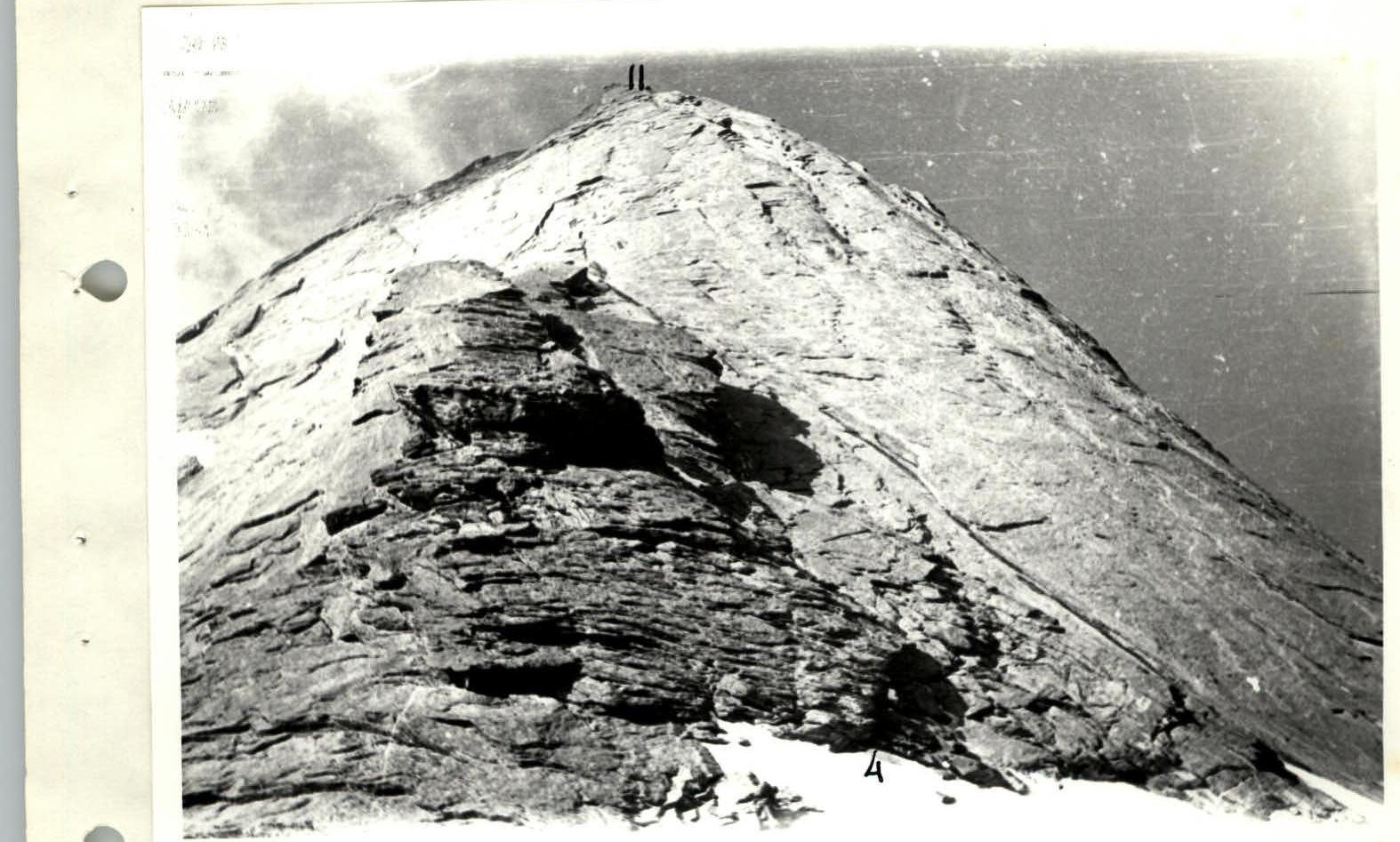
Photo 0–6. Northern wall, sections R4–R11.
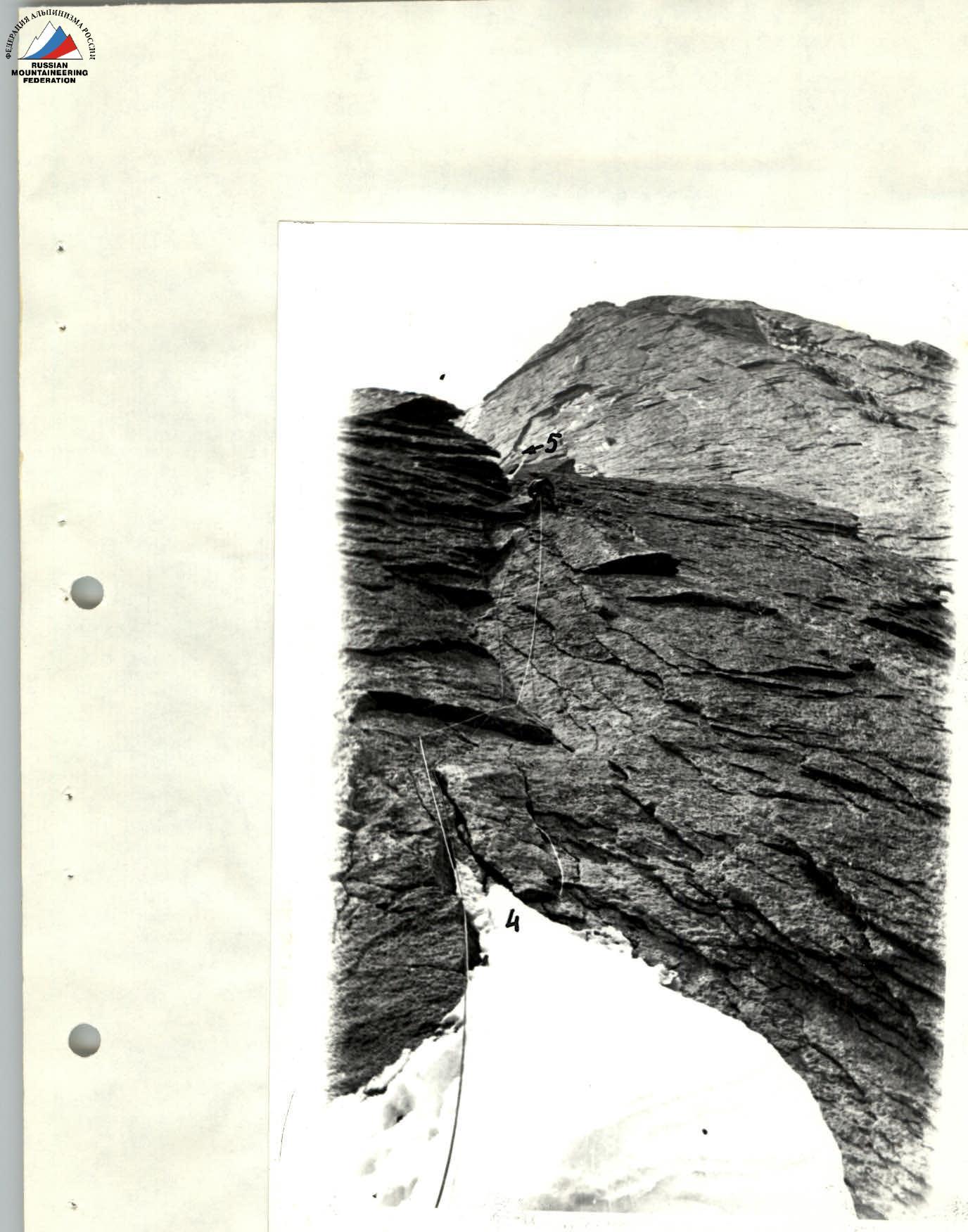
Photo 0–7. Section R4–R5. Upper part of the groove.
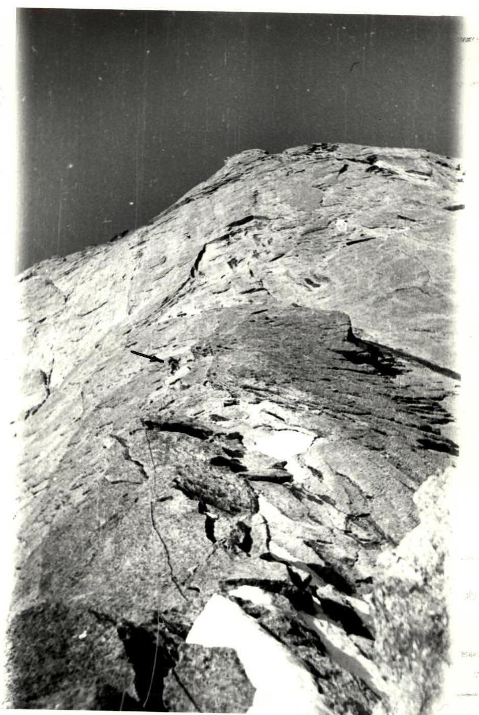
Photo 0–9. Work on section R6–R7.
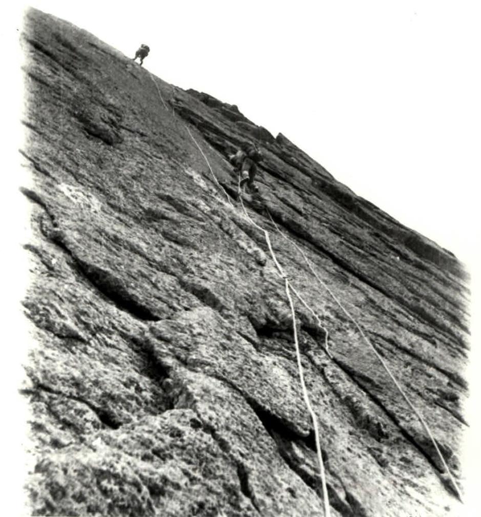
Photo 0–11. Section R10.