PASSPORT
- Class — Technical
- Pamir-Alai, Turkestan Range, Ak-Su valley
- Peak 4520 (1000th anniversary of the Baptism of Rus) via the center of the Eastern wall.
- Assumed 6B category of difficulty (first ascent).
- Height difference — 1370 m, length — 1935 m. Length of sections with 5–6 category — 770 m. Average steepness of the route — 70°.
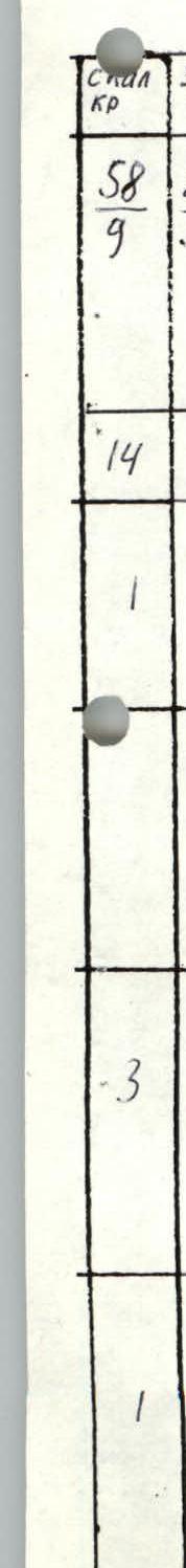
- Pitons hammered:
| rock | nuts | bolts |
|---|---|---|
| 58 | 289 | 1 |
| 9 | 52 | 1 |
- Team's climbing hours — 50; days — 4.
- Overnights: 1st — comfortable in a tent; 2nd — comfortable in a tent; 3rd — sitting separately; 4th — comfortable in a tent.
- Leader: Grigoryev Oleg Eduardovich — Master of Sports
Participants:
- Kotelnikov Anatoly Ivanovich — Master of Sports
- Voytsov Konstantin Alekseyevich — Candidate for Master of Sports
- Zaikin Andrey Alexandrovich — Candidate for Master of Sports
- Kalabushkin Vladimir Anatolyevich — Candidate for Master of Sports
- Team coach: Shabanov Anatoly Vasilyevich — Honored Coach of the Republic of Uzbekistan.
Departure to the route — July 24, 1992.
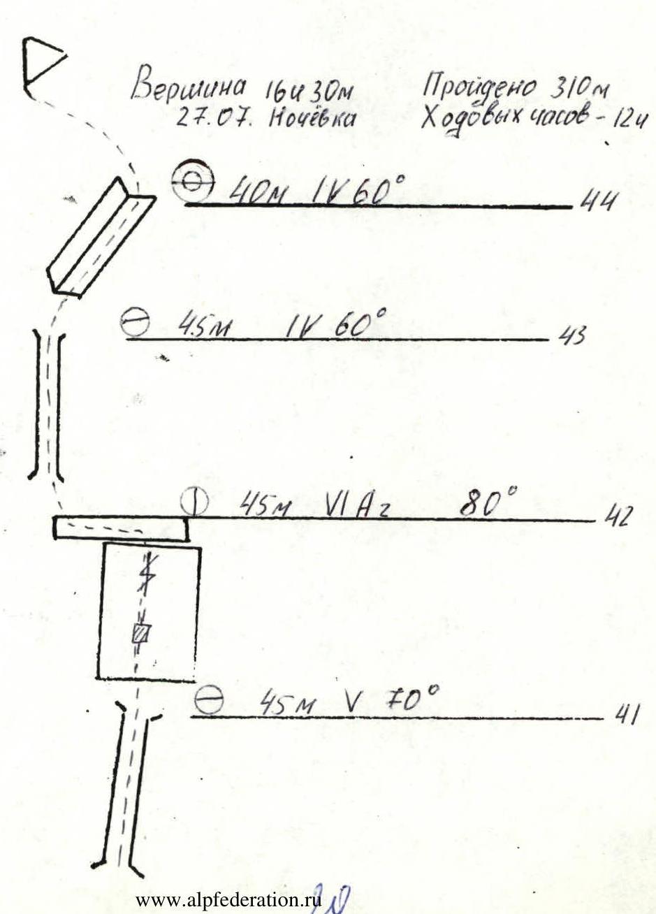
Ascent to the summit — July 27, 1992.
Return to the base camp — July 28, 1992.
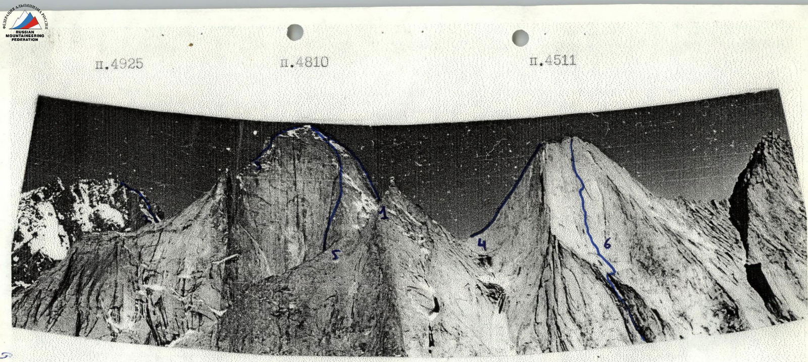
- Route of the sports club "Odessa" 1986.
- Route of the sports club "Gornik" Leningrad 1988.
- Route of the sports club "Vysota" Leningrad 1988.
- Route of the team from Dnipropetrovsk 1988.
- Route of the sports club "Vysota" on the eastern wall of peak 4810 1989.
- Route of RSCAiL, Tashkent 1992.
Tactical Actions of the Team
The team's actions on the route were determined by a developed tactical plan. The plan was drawn up after preliminary observations. Observations were made from the base camp using a 60x telescope at different times of the day, as well as from the Potankin route, which runs parallel to the chosen route. A consultation was obtained (and followed) on the descent from the summit. All members of the ascent had already been to peak 4520 and knew the descent well, but still planned to descend towards peak Kotina and then into the right couloir.
We chose a route that passes through the center of the Eastern wall, exiting directly to the summit. It is logical and safe. Based on these data, a tactical plan was drawn up.
According to the plan:
- A pair worked ahead, with the main task being to pass the designated section of the route and secure the movement of the entire group with ropes.
- One of the participants from the second pair carried equipment and, together with their partners, prepared a bivouac.
- There was a constant change of the lead climber, which allowed maintaining the group's efficiency.
All team members are proficient in all methods and types of climbing and equipment.
The work on the wall was distributed among the sections as follows:
| Section # | Lead Rope |
|---|---|
| R0–R10 | Grigoryev — Voytsov |
| R11–R21 | Voytsov — Grigoryev |
| R22–R27 | Zaikin — Kotelnikov |
| R28–R33 | Kalabushkin — Zaikin |
| R34–R37 | Grigoryev — Kotelnikov |
| R38–R41 | Kotelnikov — Grigoryev |
| R42–R45 | Zaikin — Kalabushkin |
The lead climber in the leading rope always worked on a double rope, one of which (I) was UIAA-approved, using a shock absorber. The belayer used a Sticht plate and provided top-rope belay to the second climber as they ascended the fixed ropes. The second rope worked similarly. With this movement scheme, the group's speed increased significantly. Timely replacement of the lead climber and delivery of hot drinks and food to the first rope throughout the working day allowed maintaining a fairly high pace of movement.
To organize three overnight stays on the wall, platforms were specially laid out for полноценного отдыха. Due to the lack of water and snow at the intended overnight locations on the route, the team had to carry 10 liters of water each day.
Safety on the route was ensured by:
- proper organization of movement (sheltered gathering points, belaying through blocked anchors at stations, safe overnight locations);
- participants moving within earshot and visual visibility;
- using high-quality, imported equipment that met UIAA requirements.
All ropes have good cohesion, and their interaction was planned on the route.
Observation and radio communication with the base camp and observers were conducted according to a schedule signed by the head of the rescue team. The communication was constant and stable. During the ascent, there were no falls or injuries. The descent was made from the summit towards peak Kotina and then into the couloir. Thus, the first version of the tactical plan was fully executed.
Team Leader
Grigoryev O. E.
Total Route Length and Ascent Time
Total route length — 1935 m.
Total ascent time — 50 hours.
General Photo of the Route
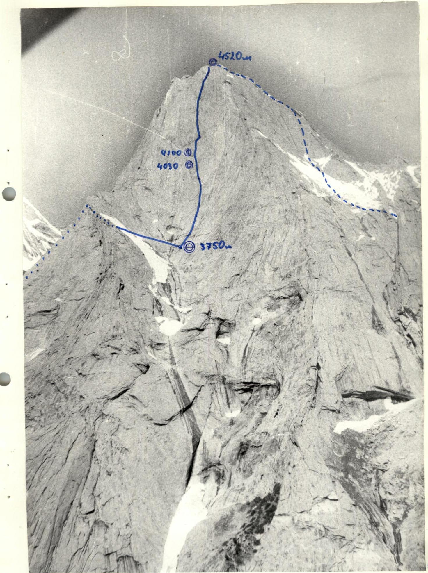
Technical Photo of the Route
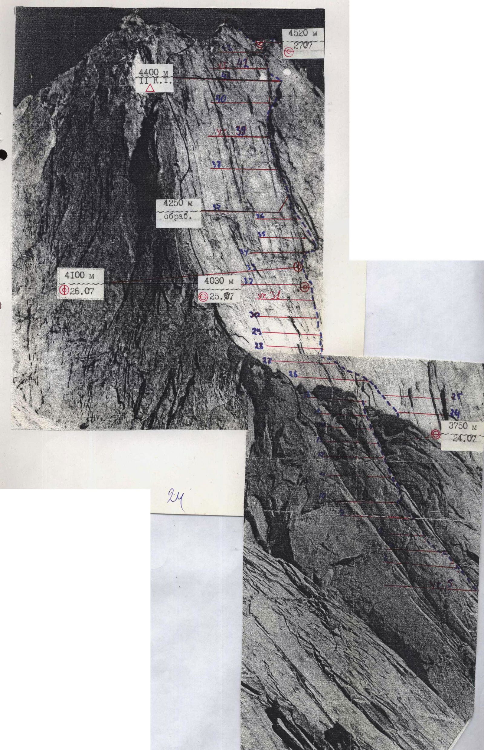
Route Profile (right)
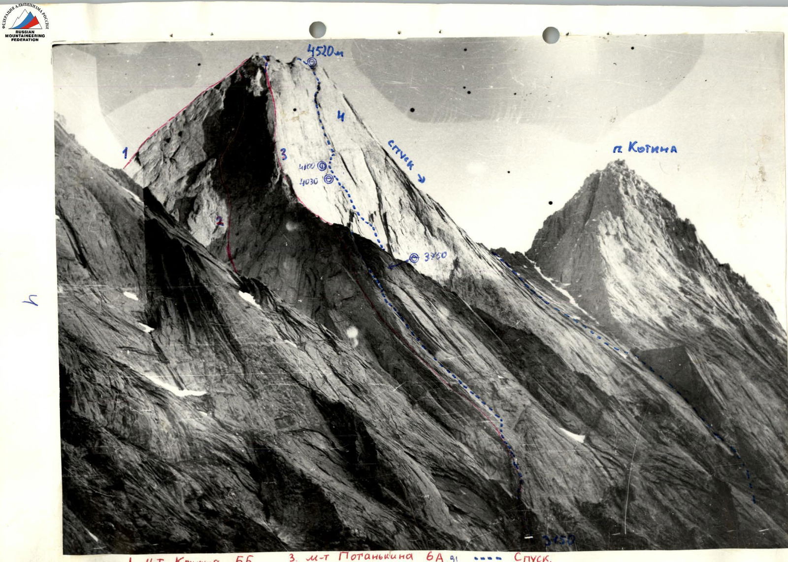
Diagram of Section R0–R10

Diagram of Section R11–R21

Photo of the Route
Technical Photo of the Couloir (traverse)

View from Section R5 (exit to the couloir, spalling on the wall)
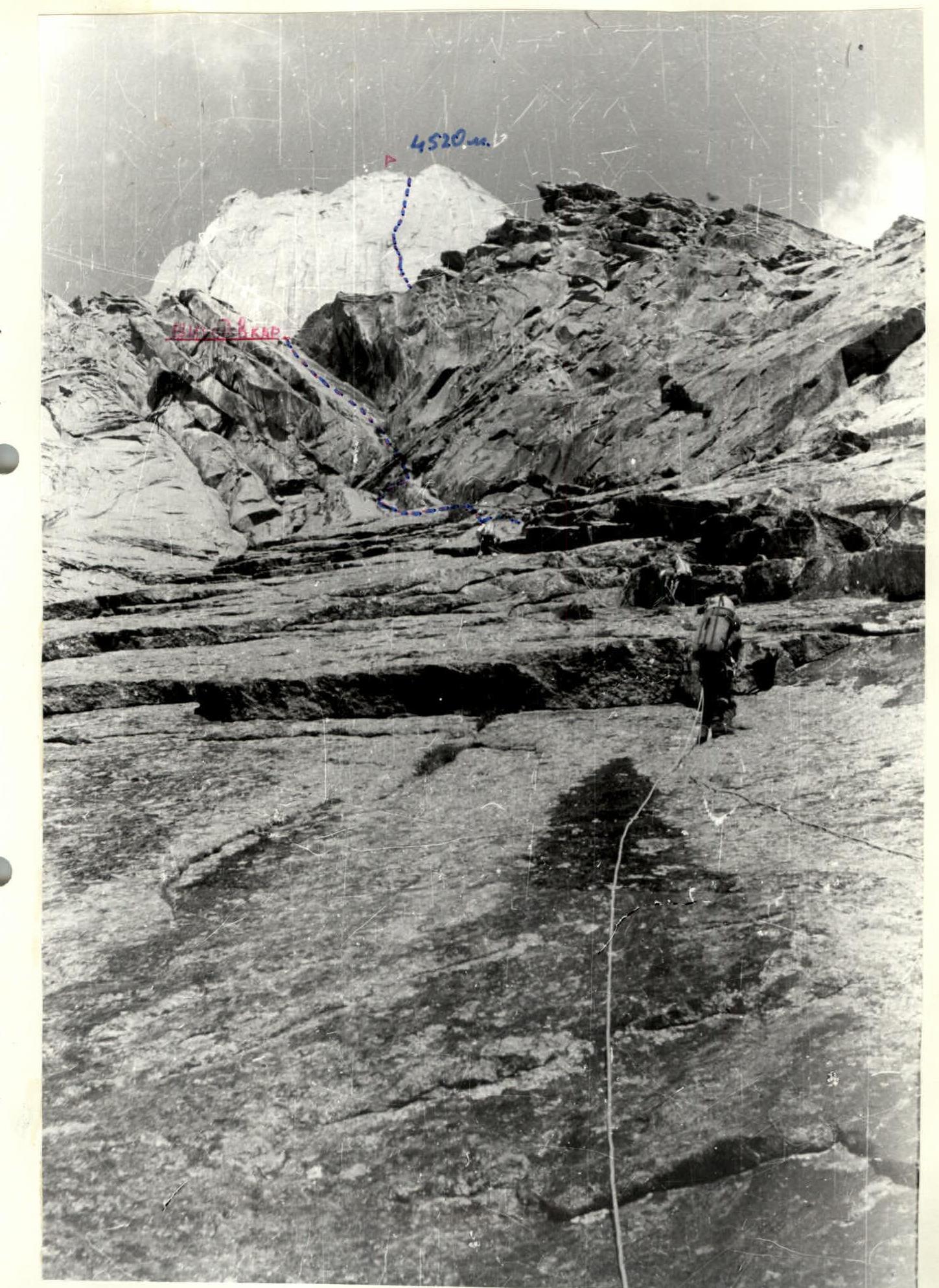
Photo of Section R34–R44

Description of the Route by Sections
The route begins on the right side of the stream flowing between the massifs of peaks 4810 and 4520. It proceeds along gentle rocks and slabs with simultaneous movement for 200 m until reaching a large wall, then moves right through a chimney to a gray slab. The start of the route.
R0–R1: along a rocky slab, friction climbing, protection via placed protection. R1–R5: movement through the left part of a large chimney, climbing of 4th category difficulty, mostly on friction. R5–R7: passing a rocky bastion directly through a cleft. R7–R10: exiting to a ledge and again through an internal corner, climbing becomes more complicated, rocks are sloping, with limited protection. R10–R11: a 6B category cornice with the use of artificial aids (AIDs), passing from right to left, traversing under the cornice and up a crack, extremely difficult climbing. R11–R16: movement through a large internal corner, in its left part. This wall has clefts, steepness increases; medium-sized friends were used during the passage, climbing is tense. Exit into a couloir. R16–R21: the couloir is traversed along its left part: first upwards diagonally to spalling and then traversing right to the base of the wall. To a good bivouac site — 50 m upwards along a "coil". The traverse is complicated due to friction climbing on wet rocks. It is advisable to collect water — there won't be any further. The bivouac is good and safe. R21–R24: the wall's beginning slowly gains steepness, movement along a barely noticeable crack. Traverse right. R24–R26: the start of a cleft is passed with the use of large friends, stoppers. The cleft becomes more complicated, gaining steepness. Passed with the use of AIDs to a piton, then a 10 m pendulum left to a cleft. During the pendulum, it's advisable to hold a medium friend in hand, then left along a ledge to the base of a large steep internal corner. R26–R29: an internal corner with an abundance of large cracks, passed in opposition with the use of AIDs. R29–R31: an internal corner transitioning into a wall, climbing in opposition and then along a crack. Exit to a safe ledge, convenient for a bivouac, 1 R.T. R31–R33: a steep wall 90 m long, tense climbing due to significant dampness. Movement first left, then traversing along a ledge right — into a cleft, with the use of AIDs. R33–R35: diagonal passage to a "shrapnel" band on the wall, complicated climbing. 15 m traverse with AIDs, approaching a large overhanging spall dividing the center of the wall. The start of the spall immediately indicates that the upcoming sections are complicated and tense. Passed with AIDs. R35–R37: spall with overhangs, left — extremely difficult climbing, mostly in opposition with constant use of AIDs for one leg, cracks and clefts are limited, holds are sloping, all equipment is used. There are several small pendulums. R37–R39: continuation of the spall. It's advisable to pass the entire spall very early, as water constantly flows during the day. Climbing is tense, steepness is 90°, includes many different cornices. Further, the route goes into a large chimney filled with water, and ice is encountered; climbing is difficult, requiring constant vigilance, all equipment is used, holds are sloping. R39–R41: continuation of the chimney, complicated climbing in opposition, water is present here. R41: upper bastion, a complicated steep slab with sloping holds, passed through a cleft: first with the use of AIDs, then with difficult climbing in opposition. R42–R44: a chimney transitioning into an internal corner, with an exit to the summit right — to a snow patch, where there's a good bivouac site under a cornice. The summit is 15 m left along the snow patch.
The descent was made along the ridge with rappels towards peak Kotina, then into the Akdu couloir — 300 m, 2nd category difficulty, to a spall in the shape of a "triangle", and then right through a large chimney to the juniper forest.
Since the team had previously descended from peak 4520 via the classic descent route, we recommend descending via the route we took — it is safer and much shorter. The descent can be made at any time, with a low real danger level.