Passport
-
Technical class.
-
Pamir-Alay, Turkestan Range, Ak-su river gorge, (Karavshin river upper reaches).
-
Peak 4520 "Millennium of the Baptism of Rus'" via the left spur of the eastern wall.
-
First ascent of category 6 complexity (tentative).
-
Route characteristics:
- elevation gain: 1356 m
- route length: 1950 m
- section lengths:
- 5–6 cat. diff. — 1210 m
- 4 cat. diff. — 470 m
- 3 cat. diff. — 270 m
- average steepness:
- main part of the spur — 73°
- entire route — 59°
- Pitons hammered:
- rock: 15
- chocks: 15
- bolts: 3
among them:
- semi-lying — 1
- lying — 2
-
Total climbing hours: 35 h (4 days).
-
Number of bivouacs: 3
-
Team leader: Potankin I.V. — MS (rock), MS (alpinism).
Kritsuk A.G. — CMS / MS; Kaurov V.O. — MS / MS; Valiev R.R. — CMS / CMS
- Team coach: Tsaruk I.F. — MS.
- Departure to the route — July 4, 1991.
Reached the summit — July 7, 1991 at 11:00. Returned to base camp — July 8, 1991 at 15:00.
- Team "Height" mountaineering club.
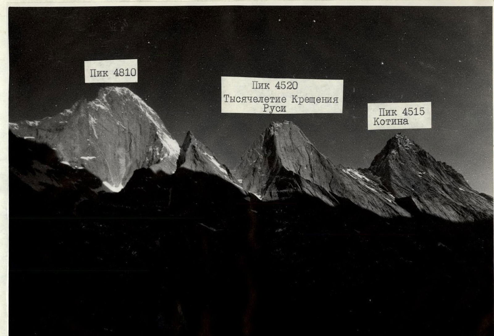
Panorama of the ascent area. Shooting point according to scheme No. 3, distance 10 km, height 3500 m. "Jupiter-12" lens, focal length 35 mm.
The team's actions on the route were determined by a developed tactical plan. It was compiled after preliminary observations. Observations were made from the base camp and observation posts opposite the wall using a spyglass. A detailed consultation on the descent from the summit was obtained from the participants of the ascent to peak 4520 in 1990.
We chose a route that passes through the center of the left spur of the eastern wall with a direct exit to the summit. It is logical and safe.
Based on these data, a tactical plan was developed, which was as follows:
- Departure from the base camp at 5:00, arrival at the route at 6:00.
- Minimize the weight of the backpack by using lightweight personal and shared gear and high-calorie food (250–300 g per person per day), allowing for fast movement along the route.
- Set up a bivouac no later than 19:00 with further route processing for the most effective work in the morning. Two options for passing the wall were developed: 1) complete the route with two overnight stays, 2) in case of bad weather — three overnight stays on the route. Due to bad weather (snow, rain in the afternoon), the ascent followed the second option.
On July 4, 1991, at 5:00, the team left the base camp and arrived at the route at 6:00. On the route, each participant worked as the first on a double rope and without a backpack. Movement along the fixed ropes was carried out with top rope on two jammers with prusik knots (due to frequent snowfalls, the fixed ropes were sometimes slippery).
Schedule of the first on the rope
| Date | Section | Lead climbers in order of movement |
|---|---|---|
| 04.07. | 0–21 | Potankin, Valiev |
| 05.07. | 21–25 | Kaurov, Kritsuk |
| 06.07. | 25–32 | Valiev, Potankin |
| 07.07. | 32–37 | Potankin, Valiev |
Organizing overnight stays on the route for two tents is problematic, so the number of participants was limited (4 people — 1 tent).
On July 7, 1991, at 11:00, the team reached the summit. No previous group's note was found due to fresh snow. They built their own cairn.
Safety on the route was ensured by proper organization of movement:
- Hiding the gathering place
- Belaying through blocked anchors at stations
- Safe places for overnight stays
- Movement of participants within audible and visible range
- First on the rope using a double rope
- Use of reliable and tested equipment
Radio communication sessions with the base camp and observers were conducted according to a schedule signed by the head of the rescue team. The communication was constant and stable.
Thus, the second version of the tactical plan, taken as the basis, was fully implemented.
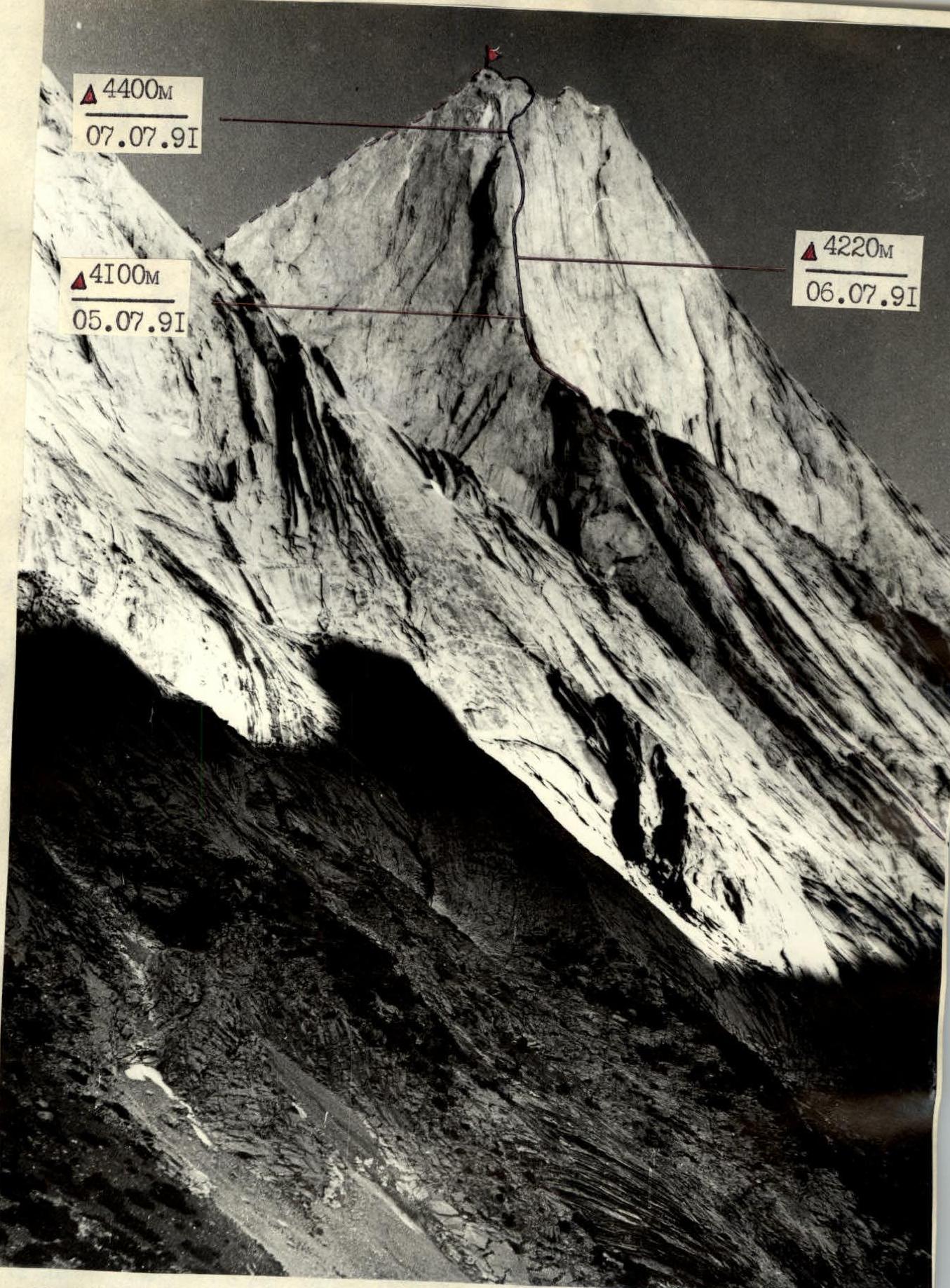
Peak 4520 "Millennium of the Baptism of Rus'"
- path of the "Height" mountaineering club team
- descent path
- overnight stays — height date
Shooting point according to scheme No. 1, distance 7 km, height 2900 m. "Jupiter-11" lens, focal length 135 mm.
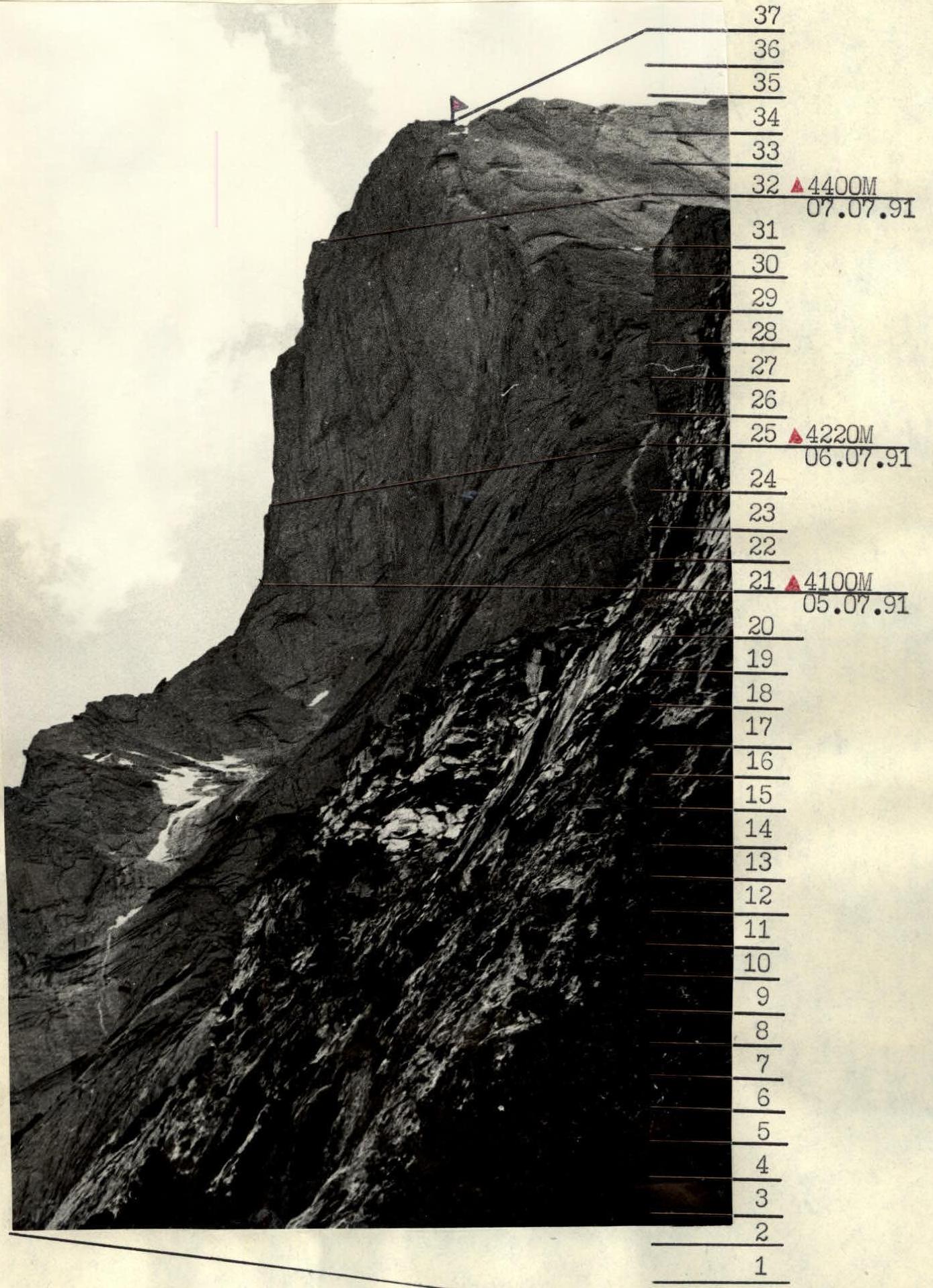
Route profile on the right:
- overnight stays
- height
- date
Shooting point according to scheme No. 2, distance 3 km, height 3300 m. "Jupiter-11" lens, focal length 135 mm.
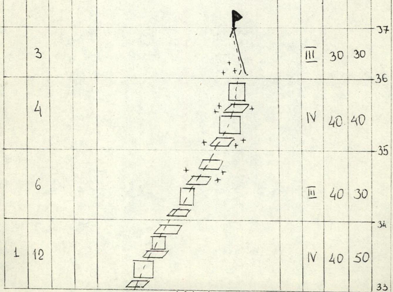
Route diagram in UIAA symbols. M1: 1300 / 1 cm = 13 m / height. Traverse sections are also taken according to the height difference.
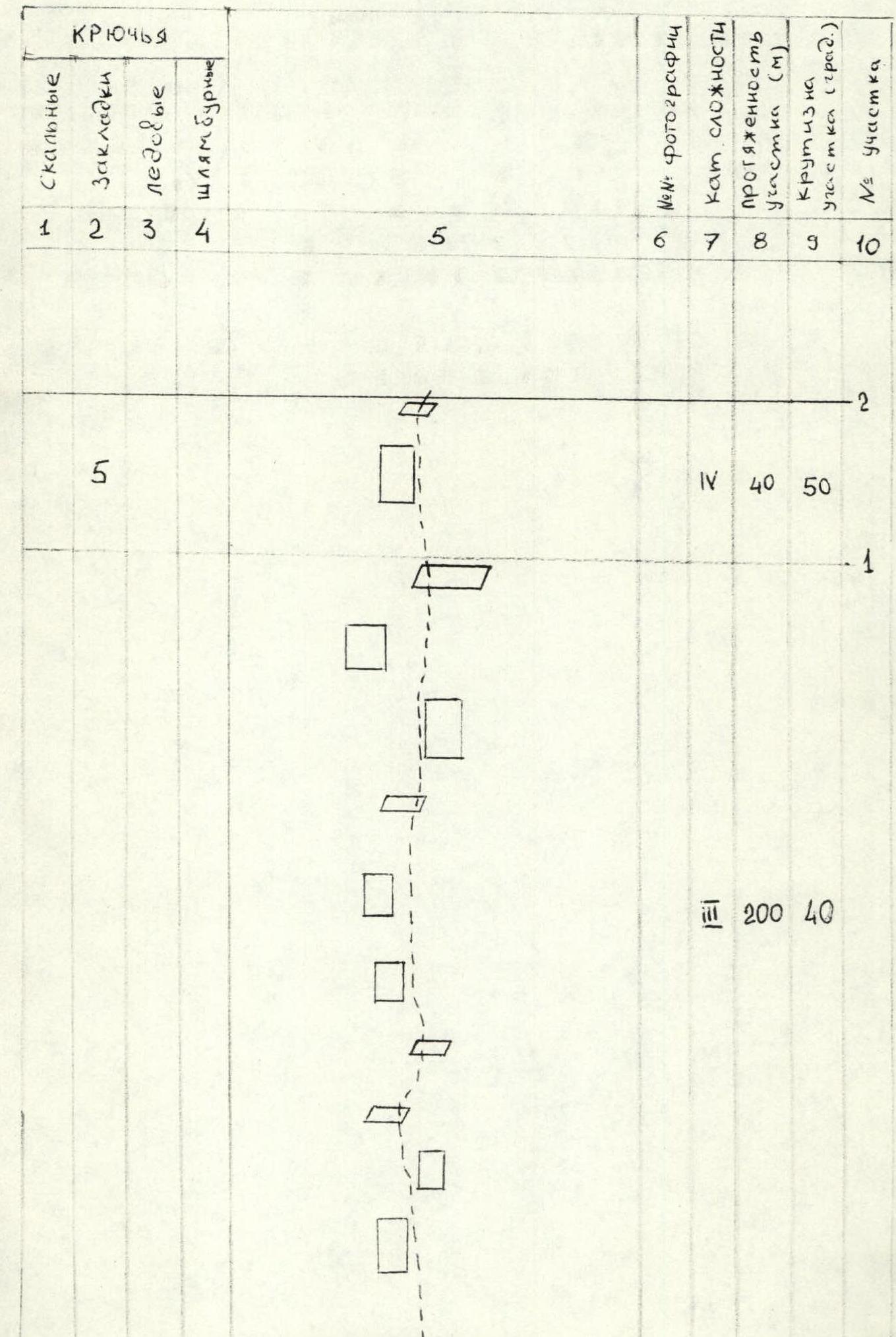
| 1 | 2 | 3 | 4 | 5 | 6 | 7 | 8 | 9 | 10 |
|---|---|---|---|---|---|---|---|---|---|
| 3 | |||||||||
| 13 | |||||||||
| 7 | 7 | ||||||||
| 40 | 65 | ||||||||
| 8 | |||||||||
| 40 | 65 | ||||||||
| 15 | |||||||||
| 6 | |||||||||
| 40 | 55 | ||||||||
| 6 | |||||||||
| 1 | 2 | 3 | 4 | 5 | 6 | 7 | 8 | 9 | 10 | ||
|---|---|---|---|---|---|---|---|---|---|---|---|
| 15 | |||||||||||
| 26 | 80 | 65 | |||||||||
| 12 | |||||||||||
| 21 | 80 | 60 | |||||||||
| _ 6 | |||||||||||
| 10 | |||||||||||
| 15 | 80 | 65 | |||||||||
| 3 | 40 | 65 | 8 | ||||||||
| t | 2 | 3 | 4 | 5 | 6 | 7 | 8 | 9 | 10 | ||
| :--: | :--: | :--: | :--: | :--: | :--: | :--: | :--: | :--: | :--: | ||
| 7 | 40 | 60 | |||||||||
| 8 | 40 | 60 | |||||||||
| 40 | 60 | ||||||||||
| 6 | 40 | 55 | |||||||||
| 13 | 40 | 70 | |||||||||
| 15 | 40 | 70 | |||||||||
| 13 | 40 | 70 | |||||||||
| 25 | 80 | 65 | |||||||||
| 1 | 2 | 3 | 4 | 5 | 6 | 7 | 8 | 9 | 10 | ||
| :-- | :-- | :-- | :-- | :-- | :-- | :-- | :-- | :-- | :-- | ||
| Completed 160 m for the day, climbing hours — 10 | |||||||||||
| 68 | 3 | 25 | |||||||||
| 32 | 3 | 24 | |||||||||
| 12 | 23 | ||||||||||
| 14 | 22 | ||||||||||
| 10 | 21 | ||||||||||

| 1 | 2 | 3 | 4 | 5 | 6 | 7 | 8 | 9 | 10 |
|---|

| 1 | 2 | 3 | 4 | 5 | 6 | 7 | 8 | 9 | 10 |
|---|
Route description by sections
The route starts on the right side of the stream flowing between the massifs of peaks 4810 and 4520.
- R0–R1 — Along gentle rocks and slabs 200 m. Simultaneous movement, belaying through outcrops.
- R1–R2 — Along rock slabs and ledges, belaying through chocks.
- R2–R3 — Movement along an internal corner. Climbing becomes more difficult.
- R3–R4 — Movement along a crack to the right and up. Climbing is difficult.
- R4–R5 — Further up along ledges and simple slabs.
- R5–R6 — To the right under the base of the slab and, bypassing it on the right along the crack, up. Climbing is difficult.
- R6–R7 — Further movement up along the slabs. Belaying through chocks.
- R7–R8 — Movement continues along a system of ledges and walls.
- R8–R9 — Further movement to the left and up along the crack and complex wall. Belaying through chocks.
- R9–R10 — Movement continues along the crack, transitioning into an internal corner. Climbing is difficult.
- R10–R11 — Further, the internal corner turns into a not clearly expressed steep couloir with monolithic walls, ending in a ledge.
- R11–R12 — To the right and up towards the base of the spur along a system of ledges and slabs.
- R12–R13 — Then to the left and up along the crack. Climbing becomes more difficult.
- R13–R14 — Continuing movement along the crack, we transition into an internal corner. Climbing is difficult.
- R14–R15 — From the internal corner to the left, and then up along the wall. Passing a series of cracks using artificial aids (AI). Exit to the ridge. Climbing is very difficult.
- R15–R16 — Movement along the left part of the not clearly expressed ridge with smoothed relief. Climbing is extremely difficult with the use of AI.
- R16–R17 — Further, bypass the outcrop on the ridge from the right side and continue movement along the wall 20 m using AI.
- R17–R18 — Movement along the ridge, along gentle slabs.
- R18–R19 — Further movement along the slabs, ending in a crack. Climbing becomes more difficult.
- R19–R20 — A series of steep walls with blind, smoothed cracks. Organizing belays is complicated.
- R20–R21 — Further along the crack and small ledges with an exit to a wide ledge under the beginning of the steep part of the spur, called the "NOSE". Here, an overnight stay is organized. The bivouac is not very convenient.
- R21–R22 — Along the wall and internal corner straight up to a small ledge and further along the wall with a crack. AI is used in some places.
- R22–R23 — Along the wall with a crack and further along the internal corner to a ledge. Climbing is extreme with the use of AI.
- R23–R24 — Movement continues along the wall 25 m and along the internal corner.
- R24–R25 — Further movement along the chimney towards the overhanging cornice. Climbing is extreme with the use of AI and bolts.
- R25–R26 — Along the chimney, approach under the cornice and bypass the cornice on the right along a narrow inclined ledge. Further along the steep internal corner. Climbing is extreme.
- R26–R27 — Movement along the internal corner using AI.
- R27–R28 — After passing the internal corner — a wall with a crack.
- R28–R29 — Along the crack to a wide ledge, which from below looks like the top of the "NOSE". A convenient place for an overnight stay.
- R29–R30 — Further along the wall with many cracks using AI.
- R30–R31 — Along a system of walls and ledges, approach the base of a large internal corner.
- R31–R32 — Further movement along the right part of the internal corner along the crack, traverse 8 m to the right and along the wall up to a ledge. Here, an overnight stay is organized.
- R32–R33 — From the bivouac, movement along the internal corner with an exit to a ledge. Climbing is extreme with the use of AI.
- R33–R34 — Along ledges and walls to the right and up towards the summit.
- R34–R35 — Along gentle, destroyed rocks under the wall.
- R35–R36 — Along the wall 10 m to a saddle under the summit tower.
- R36–R37 — Along a snowy ledge, bypass the summit tower from the west and along the rocky ridge, exit to the summit.
Descent is carried out along the ridge using rappels towards peak 4810, then from the saddle between peaks 4810 and 4520 using rappels into the couloir, along which the 5B category route to peak 4810 passes, and along the couloir also using rappels to the end of the couloir.
It is recommended to start the descent along the couloir very early in the morning due to high rockfall danger.