ASCENT DOCUMENT. 6A
-
ASCENT CLASS. ROCK.
-
ASCENT AREA, RIDGE. TURKESTAN.
-
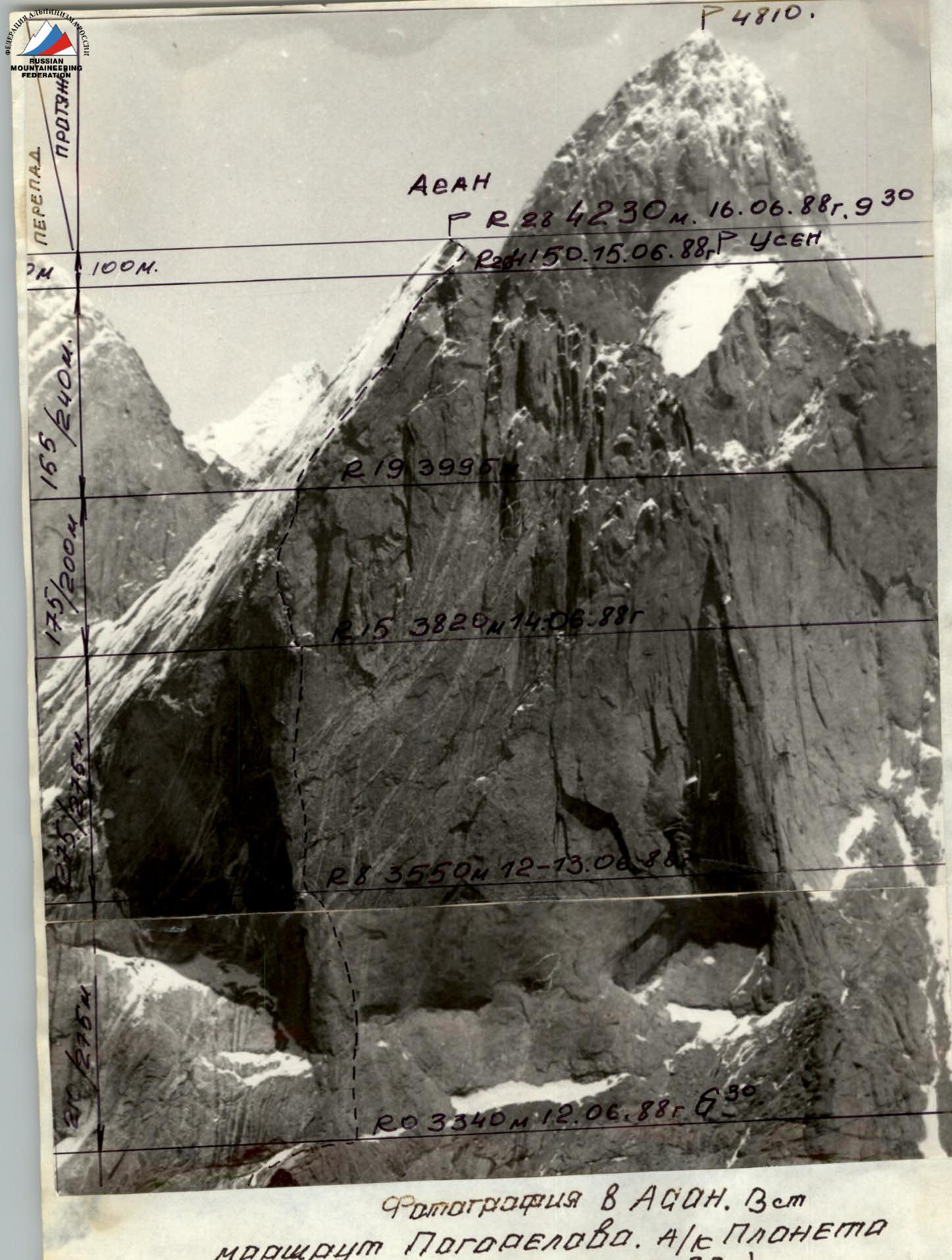
PEAK, ITS HEIGHT, ASCENT ROUTE, ROUTE CHARACTER: Asan 4230 m, 3rd wall.
-
PROPOSED DIFFICULTY CATEGORY: 6A cat. diff.
-
ROUTE CHARACTERISTICS: ELEVATION CHANGE, LENGTH OF SECTIONS OF 5/6th difficulty category, AVERAGE STEEPNESS 72°. Elevation change: 890 m. Total length: 1125 m. Length of sections with 5/6th difficulty: 475 m, steep rock: 445 m. Steepness of the wall section: 82°.
-
NUMBER OF PITOONS: FOR PROTECTION. THE NUMERATOR SHOWS THE TOTAL NUMBER, THE DENOMINATOR SHOWS THE NUMBER USED FOR CREATING ARTIFICIAL SUPPORT POINTS (ROCK, ICE, BOLT), AS WELL AS THE USE OF PLACED ELEMENTS.
-
NUMBER OF CLIMBING HOURS: 49.
-
NUMBER OF NIGHTS AND THEIR CHARACTERISTICS. The route was completed with four nights. 12–13.06.1988: semi-reclined in a tent on a ledge. Height 3550 m. 14.06.1988: semi-reclined in a tent on a ledge. Height 3820 m. 15.06.1988: semi-reclined on snow in a tent. Height 4150 m.
-
LAST NAME, FIRST NAME, PATRONYMIC NAME OF THE LEADER, PARTICIPANTS, THEIR QUALIFICATION. Balezin Valery Viktorovich — MS — leader. Kohanov Valery Petrovich — MS. Kalugin Valery Igorevich — CMS. Kolesnikov Konstantin Ivanovich — CMS. Miller Irina Petrovna — CMS.
-
TEAM COACH: Zakharov Nikolai Nikolaevich.
-
START AND END DATES FOR THE ROUTE (PEAK). 12.06.1988 — start. 16.06.1988 at 9:30 — reached the summit. 16.06.1988 — descent, return to Base Camp.
-
ORGANIZATION: SC "Enisey", Krasnoyarsk.

BRIEF DESCRIPTION OF THE APPROACH TO THE ROUTE
The peak Asan 4230 m is located in the northern spur of the Turkestan Ridge, in the Karasu gorge, a tributary of the Keravishn river. The team reached Leninabad by plane, then by bus through Isfara to the village of Vorukh. Then up the Kerovshin river by car on an abandoned road to a blockage (approximately 12 km). Then on foot: initially on an abandoned road, then on a trail, crossing several times on bridges from one bank of the river to the other until the confluence of the Aksu river from the right. Landmark — a poplar grove (about 8 hours walk). Then along the Aksu river to the confluence of the Karasu river from the right (3 hours walk). We cross the Aksu on a bridge, climb a steep ascent and enter the Karasu gorge. Then we pass a long gentle section, overgrown with forest, and at the end of the forest on a clearing we set up a base camp (2 hours from the bridge). From the base camp, approximately 1.5 hours by moraine — approach under the wall of peak Asan.
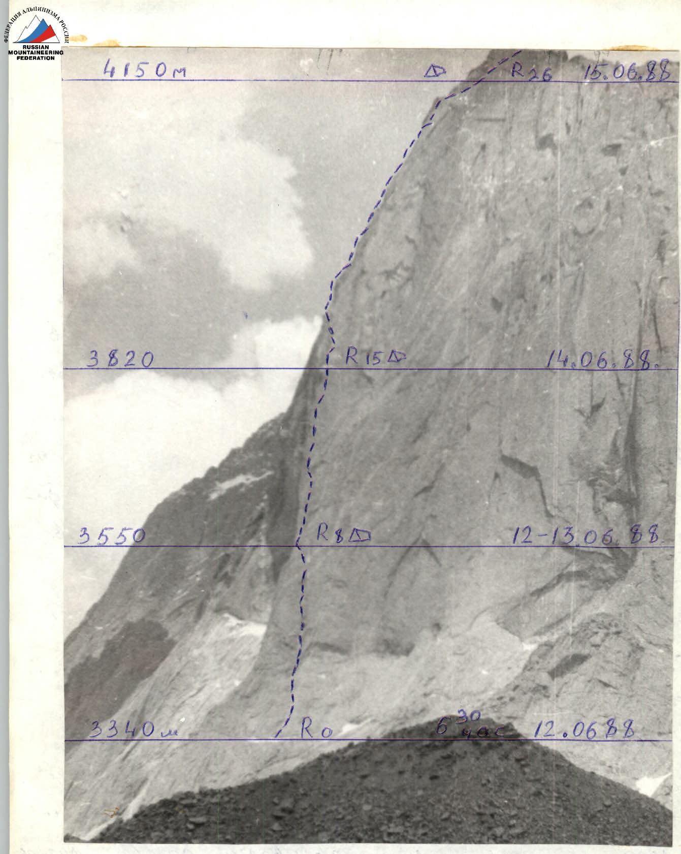 Photography. Peak Asan 4230 m 3rd wall (photographed) 09.1988.
ROUTE SCHEME IN UIAA SYMBOLS

Table of main characteristics of the ascent route Section
| Date | Designation | Length, m | Average steepness, ° | Terrain character | Difficulty | Condition | Weather conditions | Rock pitons | Bolted pitons | Placement elements |
|---|---|---|---|---|---|---|---|---|---|---|
| 12.06.1988 | 0–1 | 40 | 70 | wall, slabs. | 5 | Monolithic. | Clear | 10 | ||
| 1–2 | 50 | 55 | rocky slope | 3 | Slightly destroyed | Clear | 6 | |||
| 2–3 | 15 | 20 | ledge | I | Snow-covered | Clear | 12 | |||
| 3–4 | 45 | 75 | wall with eaves and crevices | 6 | Monolithic | Clear | 1 | 2 | 12 | |
| 4–5 | 20 | 80 | wall | 6 | Monolithic | Cloudy | 2 | 4 | ||
| 5–6 | 40 | 70 | wide crevice | 5 | Monolithic | Cloudy | 11 | |||
| 6–7 | 40 | 70 | wide crevice turning into a chimney | 5 | Monolithic | Overcast | 10 | |||
| 7–8 | 25 | 50 | Slabs, brows | 3 | Monolithic, damp | Light snow, rain | 3 | |||
| 8–9 | 15 | 75 | crevice | 5 | Monolithic | Overcast | 4 | |||
| 9–10 | 50 | 85 | Wall with crevices | 6 | Monolithic, with separate live exfoliations | Cloudy | 2 | 4 | 35 | |
| 10–11 | 40 | 85 | wall | 6 | Monolithic | Clear | 2 | 3 | 19 | |
| Overnight on the ledge, semi-reclined in a tent, p. #8 | crevices. p.1/8 | Started the route at 6:30, stopped for the night at 21:30. 15 climbing hours | Total for 12.06.1988 | 8 | 10 | 115 | ||||
| 13.06.1988 | 11–12 | 40 | 90 | Steep wall, eaves. | 6 | Monolithic, wet | Cloudy | 2 | 5 | 29 |
| 12–13 | 45 | 90 | Steep wall, crevices. | 6 | In the morning icy. Monolithic, wet rocks. | Rain, snow | 2 | 2 | 23 | |
| Overnight on the same ledge, p. semi-reclined in a tent | processed the route further. Started processing at 7:30, finished at 15:30 43-39. After lunch, it snowed, weather deterioration. 8 climbing hours | Total 30 13.06.1988 | 13 | 59 | ||||||
| 13–14 | 60 | 85 | Steep vertical crevice | 6 | Monolithic, wet, icy rocks. | Clear | 8 | 8 | 51 | |
| 14–15 | 25 | 85 | Long vertical crevice. Chimney | 6 | Monolithic, wet rocks. | Clear | 1 | 1 | 6 | |
| 15–16 | 35 | 90 | Chimney with a plug | 6 | Monolithic with separate live stones | Clear | 3 | 1 | 10 | |
| 16–17 | 40 | 80 | Inner corner, chimney | 5 | Monolithic. | Overcast | 4 | 1 | 8 | |
| Overnight on the ledge on p. #15. In a tent, semi-reclined on snow. | Left the overnight stay at (hours), stopped for the night at 21 hours. 14 climbing hours | Total 30 14.06.1988 | 12 | 13 | 75 | |||||
| 15.06.1988 | 17–18 | 50 | 90 | wall with an inclined inner corner | 6 | Monolithic | Clear | 6 | 12 | |
| 18–20 | 45 | 85 | inner corner inclined to the right | 6 | Monolithic | Clear | 2 | 4 | 7 | |
| 19–20 | 20 | 80 | Crevice leading to the roof | 6 | Destroyed | Clear | 3 | 5 | ||
| 20–21 | 45 | 60 | Slabs | 5 | Snow-covered, wet rocks | Clear | 3 | 6 | ||
| 21–22 | 40 | 60 | Slabs | 5 | Snow-covered, wet rocks | Clear | 4 | 6 | ||
| 22–23 | 40 | 60 | Slabs | 5+ | Snow-covered, wet rocks | Overcast | 4 | 8 | ||
| 23–24 | 40 | 65 | inner corner, to the right of the eave | 5 | Wet rocks | Weather deteriorating | 9 | |||
| 24–25 | 35 | 55 | Slab | 4 | Snow-covered, wet rocks | Snow, rain | 1 | 5 | ||
| 25–26 | 40 | 50 | ridge | 4 | Snow-covered | Snow, rain, thunderstorm | 4 | |||
| Overnight on snow under an awning, forced due to bad weather, thunderstorm, p. #26 | Left the overnight stay at 7:00, stopped for the night due to bad weather at 17:00. 10 climbing hours. Snowfall, thunderstorm. | Total for 15.06.1988 | 25 | 8 | 82 | |||||
| 26–27 | 70 | 60 | Inner corner | 5+ | Snow-covered and icy corner | Clear | 16 | |||
| 27–28 | 30 | 45 | ridge | 3 | Monolithic | Clear | ledges | |||
| 16.06.1988 | 9:30 reached the summit | Total climbing hours | 52 | 37 | 331 |
BRIEF EXPLANATIONS FOR THE SCHEME
12.06.1988. At 6:30 the team started the route. The first rope team is Kohanov—Kolesnikov. The first one works on a double rope UIAA, organizes the belay, all the others go on jumar with top rope protection. In the route calculations up to p. #8, it is mostly free climbing. At 14:00 the group reached p. #8. Balezin—Kohanov processed the route above. The group cut out a ledge from ice, set up a tent. At 21:30 the rope team descended to p. #8. Passing the sections above the overnight stay requires a large number of artificial aids, it is necessary to use: chocks, pitons, bolted pitons, and piton hammers. In several places it will be possible to free climb 2–3 meters. 105 m processed. 13.06.1988. At 7:30 the rope team Kohanov—Kolesnikov starts processing. In the crevices there is ice, the relief is poor, we use magnesium carbonate. For one rope, 30–50 artificial aids. At 15:30 it started raining with snow, the rope team descended to the overnight stay p. #8. Another 85 m passed. 14.06.1988. At 7:00 the rope team Balezin—Kalugin starts the ascent. The rope team is in continuous motion. A crack begins, leading to the ledge p. #15. At 12:00 another 50 m of the wall was passed. The rope team gives a signal to the group to start. At 17:30 the whole group reached p. #15.