— 1 — 6А 2-е μ² 4¹/² 4¹/²
Peak Asan (4230 m) via the NW wall center, 6А cat., Gorbенко route, 1986. Pamir-Alay, Turkestan Range. Karavshin gorge.
Ascent Passport
-
Ascent plan — technical
-
Ascent area — Pamir-Alay, Turkestan Range, Karavshin gorge
-
Peak Asan (4230 m) via the NW wall center, Gorbенко (Odessa) route, 1986, ninth ascent
-
Cat. — 6А
-
Height difference — 830 m.
Length — 1015 m; including 5–6 cat. — 865 m, with 6 cat. — 415 m.
Average slope — 78°, 6 cat. — 85°.
-
Pitons: rock — 22/8, bolt — 47/43, protection — 245/92
-
Climbing hours — 37
days — 4 + 1 day of processing.
-
Overnights on the route — 3
-
Team leader — Shagaeva E. M. — CMS, participants:
- Lavrinenko A. V. — CMS
- Kruglov Yu. I. — CMS
-
Route entry — July 24, 1999
Summit — July 27, 1999, return — July 28, 1999
-
Team of Ryazan regional federation of alpinists and rock climbers.
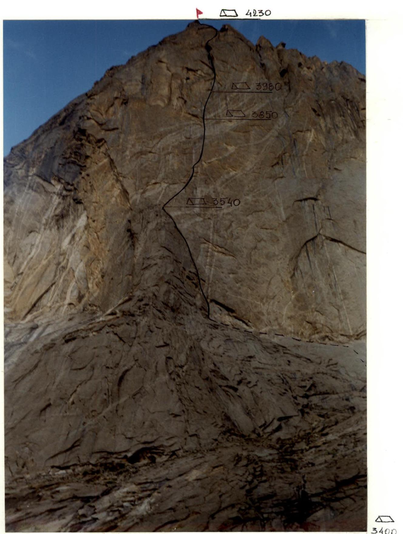
Profile of the NW wall of p. Asan (right — the last camp before the base camp)
Brief overview of the area and the ascent object
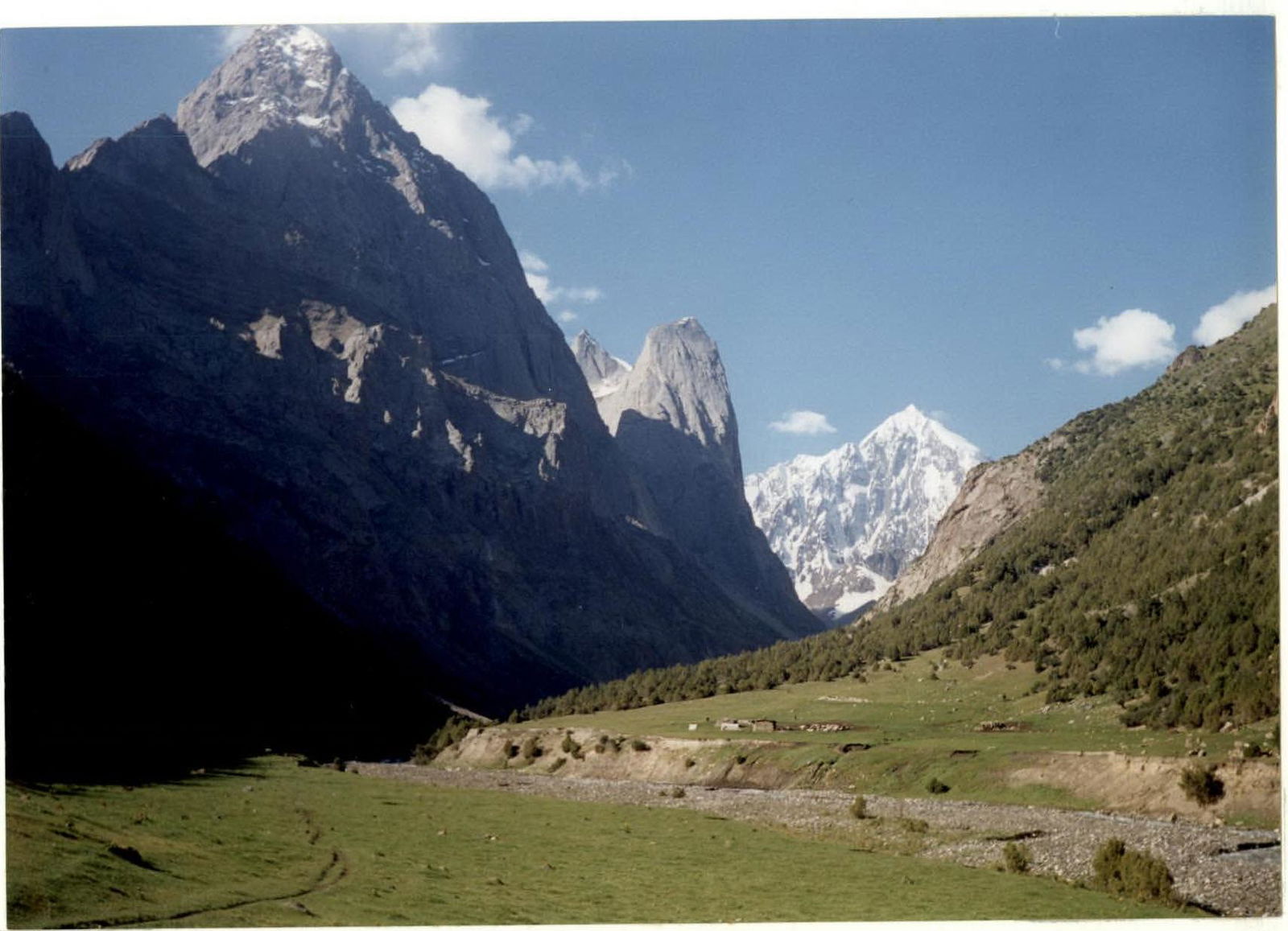
The object of the team's ascent within the framework of the Russian Championship in mountaineering in the technical class is Peak Asan, located in the Asan-USen massif in the northern spur of the Turkestan Range, in the Karavshin gorge on the Pamir-Alay.
Toponymy: Asan and Usen are traditional names for twin boys in Muslim families; the peaks, as seen from the Karavshin gorge, being in the same massif, are very similar to each other, like twins.
The height of the peak is 4230 m; the length of the walls that drop to the northwest and northeast is just under a kilometer. To the north, the massif continues with a short spur; to the south — with a ridge connecting it to Peak 4810. The dominant high point of the area is Peak Piramidalny (5509 m). The massif is composed of strong granites cut through by quartz veins. There are practically no spontaneous rockfalls on the walls, although large blocks fall during earthquakes. The entire area, including this massif, is rich in choices of mountaineering routes of the highest category of complexity, as well as the possibility of making first ascents of 4–6 category of complexity.
The area gained popularity in mountaineering circles since 1986, when first ascents were made on p. Asan by teams from Rostov, Odessa, and Dnepropetrovsk within the framework of the USSR Championship in the rock climbing class.
The climate of the area is moderately continental.
The Karavshin valley can be reached as follows:
- From Isfara city by bus — 40 km to Vorukh village. Further, by car along the Karavshin river gorge to the blockage — 10 km. Then, on foot to the abandoned road, and then along the pack trail up the Karavshin river gorge to the confluence of the Urta-Chapima river (5–6 hours from the blockage). Here, the Karavshin river gorge turns left. Along the left bank of the river, reach the confluence of the Djopaya river. Further, to the right — up, first on the right, then on the left side, cross the Ak-Su river, ascend up the Karav-Su river gorge. The path from the blockage takes 13–15 hours.
- From Vorukh village (lower apricot garden) with the help of donkeys, accompanied by handlers, to the destination (about one and a half days with a load uphill).
- By helicopter from Tashkent (2.5 hours).
Peak Asan (general view)
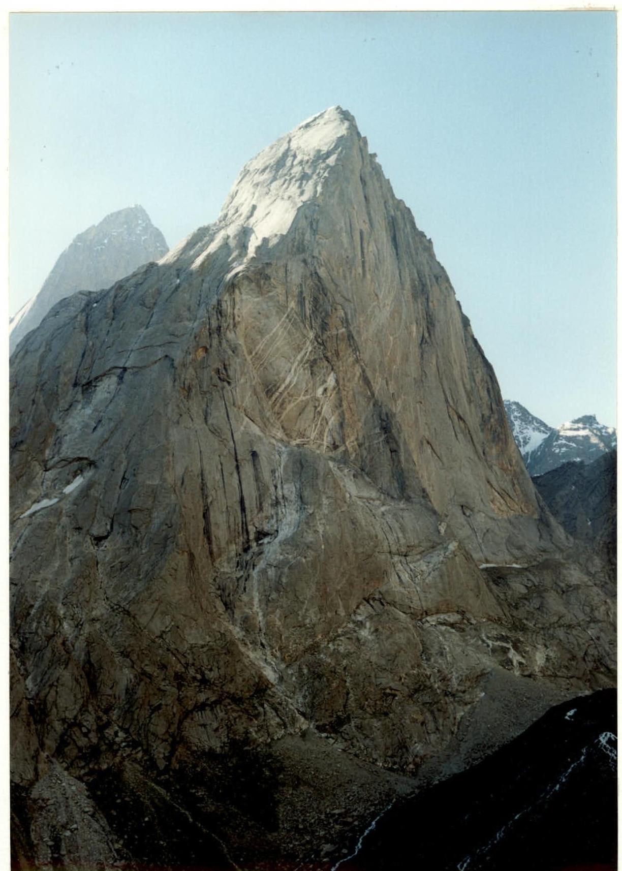
Photo from p. Yellow Wall (lens "Smena-Symbol")
Date taken — 1999. Distance — 2.5 km; Height — 3700 m.
Scheme of classified routes on the Northwest wall of Peak Asan (4230 m)
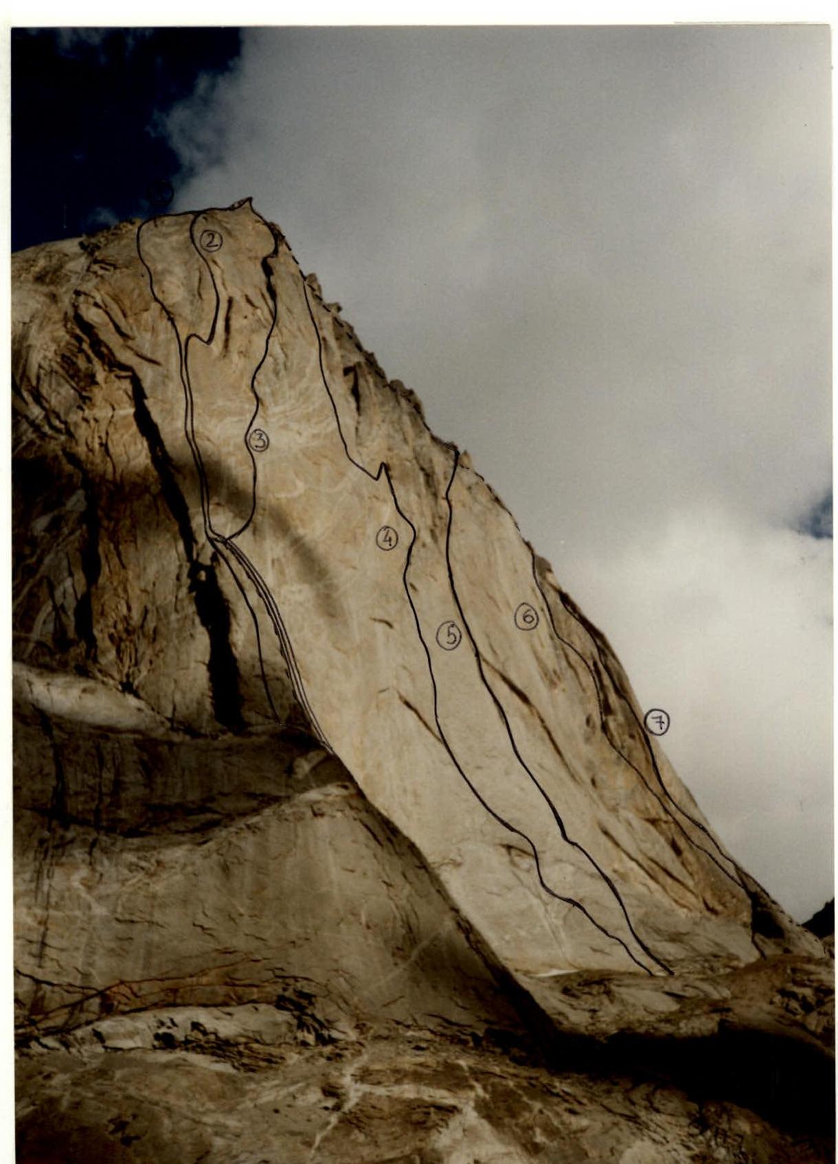
- Pogorelova via NW wall 6А — 1986
- Moroz via NW wall 6А — 1986
- Gorbенко via NW wall center 6А — 1986
- Rusyaev via NW wall center 6А — 1988
- Timofeev via right part of NW wall 6А
- American via right part of NW wall — 6А — 1999
- Alperin via NW wall edge — 5Б — 1986
Northwest wall of Peak Asan (general view)
Gorbенко (Odessa) route via the center
Tactical actions of the team
The results of the reconnaissance, study of reports, and photographic materials of the NW wall of p. Asan formed the basis of the tactical ascent plan. The route was planned to be climbed with three overnight stays and one day of preliminary processing. In reality, the route was climbed from July 23, 1999, to July 27, 1999, with one day of processing and an overnight stay on the summit.
The team consisted of:
- Shagaeva E. M. — team leader;
- Lavrinenko A. V. — participant;
- Kruglov Yu. I. — participant.
The team composition ensured optimal work and rest on the route in terms of even workload distribution among team members. The bivouac equipment was selected considering the nature of the planned overnight stays. To pass the route, experience with skyhooks and bolt climbing techniques was necessary.
Ascent schedule
July 23, 1999 — The whole team worked: fixed sections R0–R1 and R1–R2; carried water, food, and equipment to R2; descended under the route. 17:00 — overnight stay, good weather, rain at night.
July 24, 1999 — At 7:00, ascent, approach to the route, jumared to R2; continued on the route to R5 (12:00), where they set up a bivouac and pitched a tent on a good ledge on the "pillar"; simultaneously with setting up the bivouac, continued processing the route to R7 (Lavrinenko–Kruglov). On section R5–R7 — work on skyhooks on relief and on holes (holes mostly in very poor condition, on relief they hold very well). At 19:00, everyone gathered at the overnight stay. Weather deteriorating — cloudiness, wind, drizzle with snow.
July 25, 1999 — At 6:00, started ascent on jumars to R7, lifted the load. Continued to R14 (Kruglov–Lavrinenko rope team). The rope team worked alternately, changing the lead on each section. The average steepness of the section climbed during the day was 85–90°. Before the overnight stay, from under an overhang, a "good" pendulum to the left with an amplitude of more than 20 m. Set up an overnight stay on a convenient flat ledge 1×2 m at 19:00. Weather — strong wind, variable cloudiness, sometimes snow and graupel.
July 26, 1999. At 6:00, continued from R14 to R17, lifted the load. Ledge 50×120 cm, in the form of a "trough", with water flowing down the walls. On the same day, continued processing to R19. Had to work on wet walls and streams, as everything could freeze in the morning. Finished work at 20:30. All day — cloudiness, graupel, visibility 10–20 m. At night, in the first half, snow, graupel, towards morning — rain.
July 27, 1999. At 6:00, ascent. The first rope, frozen overnight and partially stuck to the wall, had to be climbed again using artificial aids. R19–R20 — the steepest, overhanging section of the route (Lavrinenko–Shagaeva rope team). The chimney section R21–R22 is filled with ice. On R23–R24 — the chimney is also filled with ice, "live rocks" are encountered. On section R25–R26, according to the description, 4 cat. sl., due to ice in the upper part, it's difficult to organize protection. Bypassed to the right along an overhanging crack 20 m, 4 cat. sl. Reached the summit at 21:00. This day was the most intense for the entire team. Poor weather conditions and, as a result, the deterioration of the route state led to a deviation from the tactical plan and an unplanned overnight stay on the summit (4230 m). This overnight stay was necessary to mobilize the team's forces and successfully descend.
July 28, 1999. Started descent at 7:00, were in camp by 11:00.
There were no falls on the route. Throughout the ascent, video and photo shooting were conducted.
Route description by sections
R0–R1: Steep internal corner with a slit, climbed free. Protection — protection devices. 40 m. 80°. R1–R2: Overhanging internal corner, climbed using artificial aids (protection devices), then bypassing a cornice to the right (piton-protection devices), reach a ledge. 45 m. 90°. R2–R3: Along the internal corner, then along the wall, climbed free, reach a ledge at the base of the internal corner. Protection — protection devices. 40 m. 70°. R3–R4: Internal corner, climbed free. Protection — medium protection devices. 30 m. 70°. R4–R5: Simple, destroyed rocks lead to a ledge. Overnight stay location (3550 m). 20 m. R5–R6: From the ledge to the right-up, first free climbing along shattered rocks, then on artificial aids (skyhooks) along a steep, monolithic slab, reach the base of a chimney. Protection — bolt and slit pitons. 60 m. 90°. R6–R7: Chimney formed by a wall and a slab. Climbed free. Protection — large protection devices, one bolt piton. 30 m. 85°. R7–R8: Steep slit, climbed free (friends, large protection devices), leads to a ledge suitable for a sitting overnight stay (3670 m). 60 m. 80°. R8–R10: Steep wall, almost without relief. Climbed mainly on artificial aids (skyhooks, pitons). Protection — bolt pitons. 100 m. 85°. R10–R11: Vertical wall turning into an overhang. Climbed on artificial aids (skyhooks, protection devices, bolt pitons). 40 m. 90°. R11–R12: Crack, climbed free. Protection — protection devices, friends. 40 m. 80°. R12–R13: From under an overhang, a pendulum to the left. 20 m. R13–R14: Along a slit (large protection devices) climbing to a ledge convenient for an overnight stay (3850 m). 20 m. 80°. R14–R15: Along a slit, climbed free, to the right-up to a sloping ledge. Protection — protection devices, pitons. 30 m. 70°. R15–R16: Internal corners alternating with ledges. Direction — to the right-up. Protection — Tips with protection devices. 60 m. 70°. R16–R17: Steep internal corner with a slit, climbing, partly on artificial aids (protection devices, friends). 30 m. 90°. R17–R18: Slits, climbed free (protection devices), lead to a ledge, possible sitting overnight stay. 50 m. 80°. R18–R19: Along a crack, then along a slit on the right wall of a huge chimney closed by cornices in the upper part, approach under an overhang. 50 m. 90°. R19–R20: Overhanging slit, climbed using artificial aids (protection devices, friends). 20 m. 95°. R20–R21: Slit, climbed free (protection devices), leads to the base of a wide chimney. 30 m. 70°. R21–R22: Chimney, overhanging in the middle part, ice encountered. Climbed initially by steming, then on artificial aids (piton, small protection devices), in the upper part — free climbing. 50 m. 90°. R22–R23: Simple, destroyed rocks. 30 m. 50°. R23–R24: Chimney with ice, "live rocks" encountered, climbing is tense. 50 m. 80°. R24–R25: Inclined ledge leading to the base of an internal corner. 30 m. 30°. R25–R26: Open internal corner, ice in the upper part. Difficult to organize protection. 50 m. 65°. R26–R27: Inclined snow-covered ledge. 20 m. 30°. R27–R28: Steep wall with rich relief. Climbed free. Protection — protection devices, 3 bolt pitons. 50 m. 80°. R28–R29: Simple, weathered rocks of the ridge lead to the summit (4230 m). 60 m. 50°.
Descent into the 4810 cirque
UIAA scheme

| № Section | Rock Pitons | Protection Pitons | Bolt Pitons | Symbols | UIAA | Cat. | Length (m) | Steepness (°) |
|---|---|---|---|---|---|---|---|---|
| R0–R1 | 2 | 7 | – | 5 | 40 | 80 | ||
| R1–R2 | 3 | 10/4 | – | 5 | 45 | 90 | ||
| R2–R3 | – | 6 | – | 4 | 40 | 70 | ||
| R3–R4 | – | 6 | – | 4 | 30 | 70 | ||
| R4–R5 | – | 2 | – | 3 | 20 | 45 | ||
| R5–R6 | 4/4 | 9/9 | – | 6 | 60 | 90 | ||
| R6–R7 | – | 4/2 | 1 | 5 | 30 | 85 | ||
| R7–R8 | – | 22/10 | – | 5 | 60 | 80 | ||
| R8–R10 | – | 16/16 | – | 6 | 100 | 85 | ||
| R10–R11 | – | 10/6 | 8/8 | 6 | 40 | 90 | ||
| R11–R12 | 2 | 14/10 | 2/4 | 5 | 40 | 80 | ||
| R12–R13 | – | 7 | 1 | 5 | 20 | 80 | ||
| R13–R14 | 2 | 4 | – | 4 | 30 | 70 | ||
| R14–R15 | – | 16 | – | 5 | 60 | 70 | ||
| R15–R16 | – | 12/8 | – | 5 | 30 | 90 | ||
| R16–R17 | 1 | 10 | – | 5 | 50 | 80 | ||
| R18–R19 | 4/4 | 19/17 | 4/4 | 6 | 50 | 90 | ||
| R19–R20 | – | 15/13 | 1/1 | 6 | 20 | 95 | ||
| R20–R21 | – | 16/11 | – | 6 | 30 | 70 | ||
| R21–R22 | 2 | 10/5 | – | 5 | 50 | 90 | ||
| R22–R23 | – | 8 | – | 4 | 30 | 50 | ||
| R23–R24 | 2 | 13 | – | 5 | 50 | 80 | ||
| R24–R25 | – | 5 | – | 3 | 33 | 30 | ||
| R25–R26 | – | 12/6 | – | 4 | 50 | 65 | ||
| R26–R27 | – | 5 | – | 3 | 20 | 30 | ||
| R27–R28 | – | 12/0 | 3 | 5 | 50 | 80 | ||
| R28–R29 | – | – | – | 2 | 60 | 50 |