- Climbing category — rock.
- Climbing area — Pamir-Alay, Turkestan Range, Karasu river valley.
- Summit — Peak Asan (4230 m), right part of the western wall.
- Proposed route — 5B category of difficulty, Alperin route variant.
- Route length — 1200 m.
Height difference — 880 m. N-T Pleskacheva 2nd. Length of sections with 5B category of difficulty — 690 m. Average steepness of the wall part of the route (3420–4130 m) — 78°. Sections of 6th category of difficulty: 82° (3480–3550 m), 80° (3570–3610 m), 86° (3685–3765 m).
- Pitons hammered: rock (75/32), bolt (4/4), chocks (128/61), skyhooks (5/5).
- Climbing hours — 31, days — 4.
- Overnight stops — 1st and 2nd bivouacs on 6 people.
- Team leader — Klyunin Oleg Stanislavovich — Candidate Master of Sports.
Team members:
- Glushko Elena Yuryevna — Master of Sports
- Kritsuk Sergey Georgievich — 1st sports category
- Lenivkova Zinaida Dmitrievna — Master of Sports
- Sagurov Andrey Petrovich — 1st sports category
- Tibeykin Leonid Artemovich — Master of Sports
- Coach — Glushko Vyacheslav Ivanovich — Honored Master of Sports.
- Departure to the route — July 5, 1988. Ascent to the summit — July 6, 1988. Return to the camp — July 7, 1988.
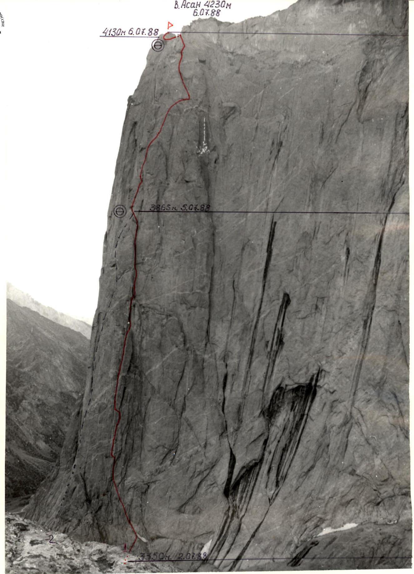
Photo 1. General view of the summit. Route taken by the team.
- Date and time of shooting: July 4, 1988 11:00
- Lens: "Mir-26V" (45 mm)
- Shooting point: № 1
- Distance: about 600 m
- Height: 3600 m
2nd variant of Alperin's route on the western wall, 5B category of difficulty.
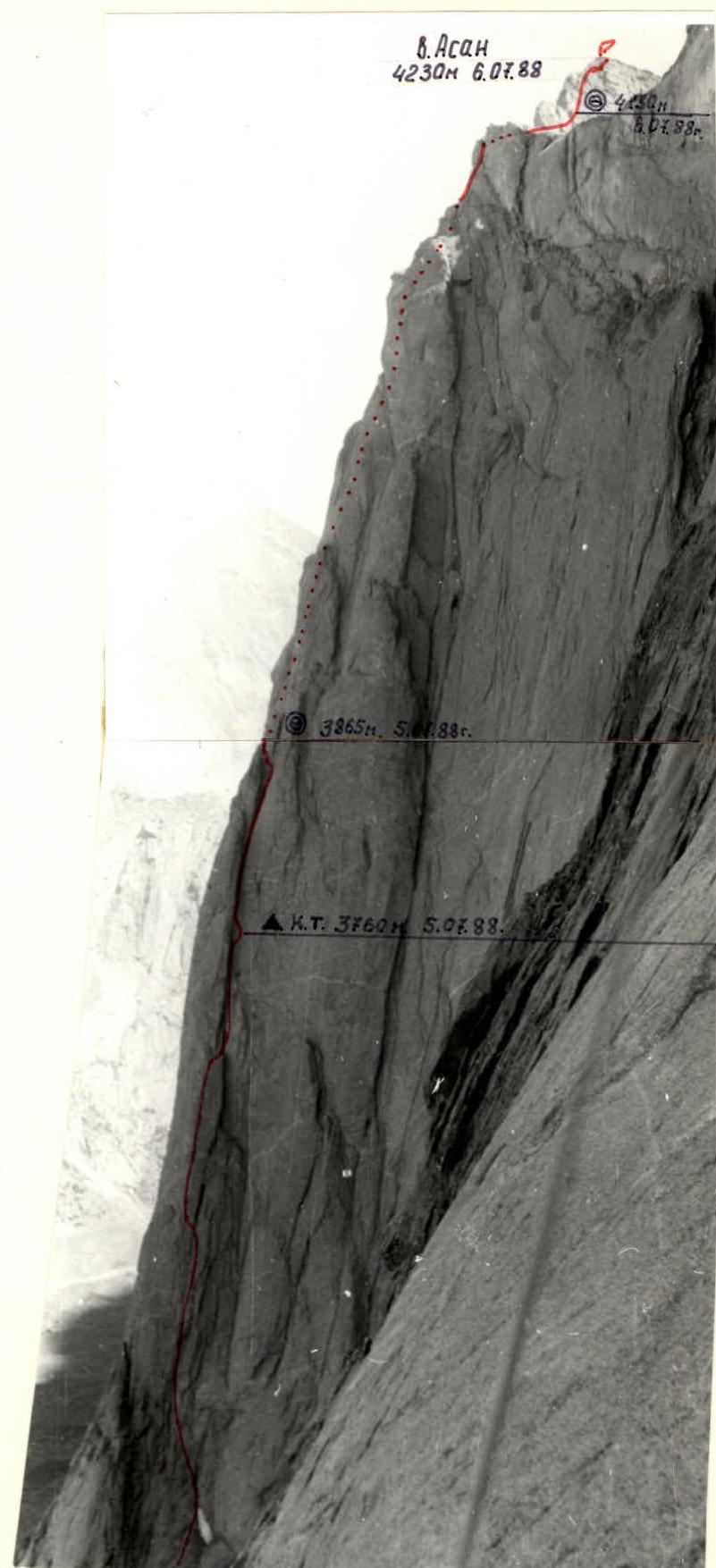
Photo 2. Route profile from the right.
- Date and time of shooting: June 28, 1988 10:00
- Lens: T-43 (40 mm)
- Shooting point: № 2
- Distance: about 700 m
- Height: 3600 m
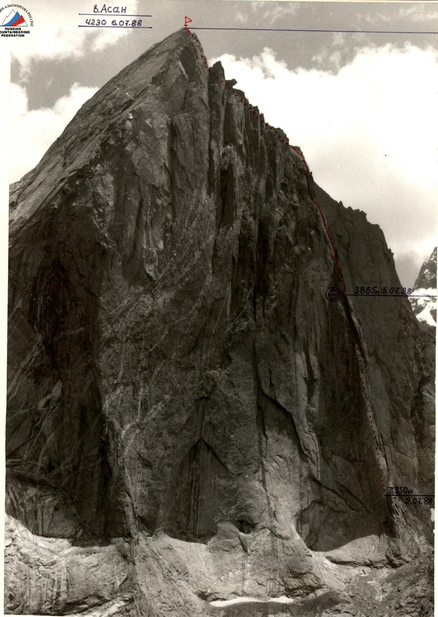
Photo 3. Route profile from the left. Date and time of shooting — July 2, 1988 14:00. Lens — "Volna 3M" (80 mm). Shooting point — № 3. Distance — about 2.5 km. Height — about 3400 m.
The team worked on the route based on a tactical plan. However, due to the team's involvement in rescue operations in the area, it was adjusted after the first day of work and looked like this:
- July 2 — approach to the route, observation and photography of the route, processing of section R0–R5.
- July 3 — processing of section R5–R14, ascent to the rock "finger".
- July 5 — departure to the route, overnight stay on the route.
- July 6 — ascent to the "roof" and to the summit. Overnight stay on the summit.
- July 7 — descent to the base camp.
The team's work was organized in pairs:
- The task of the first pair was to pass the section of the route as quickly and safely as possible and secure the rope.
- The second in the rope team — after securing the rope, moved along the rope on two jumar with top rope, carrying a free rope.
- The third — moved along the rope with two jumar and with bottom rope, clicking the rope through the left points. He was belayed by the fourth.
- The fourth — moved along the rope with top rope, straightening the rope and eliminating unnecessary intermediate points.
- The last — moving with top rope along the rope, removed belay points and remaining intermediate points.
Belay stations were organized from three to four blocked points in places protected from rocks. The leaders in the first rope team changed after a day's work.
The first to work were:
- Kritsuk on sections R0–R5, R8–R12
- Sagurov on sections R3–R8, R13–R22
- Tibeykin on sections R12–R13, R22–R24. The order of work with the first corresponded mainly to the tactical plan.
The first in the rope team worked on a double rope. The high technical preparation of the participants allowed for the effective use of modern technical means — chocks, "friends". Bolts were used as rock anchors.
Movement on the route was continuous and only during daylight hours. In the morning and evening, hot meals were prepared, and during the day, participants were given pocket food. Overnight stays were at planned locations, lying down. In case of bad weather, the team had:
- reserve food
- fuel
During the passage of the routes, there were no accidents or injuries. Safety on the route was ensured by:
- high individual skill of the participants
- good material support of the group
- competently drawn up tactical plan.
Radio communication with the base camp was carried out on RPT-22 radios according to a schedule and was stable. The team's actions on the route were observed with the help of 7x binoculars by a pair of observers Dorofeev – Pashkevich.
Route scheme in UIAA symbols
| (1) rock pitons | (2) chocks | (3) skyhook | (4) bolt pitons | (5) category of difficulty | (6) length (m) | (7) steepness (°) | (8) section № | (9) altitude (m) |
|---|---|---|---|---|---|---|---|---|
| 1 | 16/7 | – | – | VI, А2 | 40 | 90 | 9 | Photo 9–10 |
| – | 6 | – | – | V | 60 | 70 | 20 | |
| 4 | 7 | – | – | V+ | 40 | 80 | 19 | Photo 20–21 |
| 5 | 3 | – | – | V– | 40 | 70 | 18 | |
| 1 | 7 | – | – | V | 40 | 75 | 17 | |
| – | 2 | – | – | IV | 20 | 60 | 16 | |
| 4/1 | 1 | – | – | V+, А1 | 20 | 80 | 15 | |
| 5 | 5 | – | – | V | 40 | 70 | 14 | Photo 17–19 |
| 8 | 3 | – | – | V | 40 | 75 | 13 | 3865 |
| Total for July 5, 1988 | (12/5, 57/32, 5) | (2/2) | Climbing hours 10 | 12 | Photo 14–16 | |||
| 6/2 | 7/3 | – | – | V, А2 | 40 | 80 | 11 | |
| – | 7 | – | – | V– | 30 | 80 | 10 | |
| 5/3 | 22/22 | 5 | 2/2 | VI, А3 | 40 | 85 | 9 | Photo 11–12 |
| 1 | 16/7 | – | – | VI, А2 | 40 | 90 | 9 | |
| Total for July 4, 1988 | (28/26, 15/4) | – | (2/2) | Climbing hours 9 | 8 | 3685 | ||
| 1 | 2 | – | – | V+ | 80 | 80 | 7 | Photo 8 |
| 10/9 | 7/3 | – | 1/1 | VI, А3 | 40 | 80 | 6 | Photo 7 |
| 2/2 | 3/1 | – | – | V+, А1 | 20 | 85 | 5 | |
| 15/15 | 3 | – | 1/1 | VI, А3 | 30 | 80 | 4 | 3520 |
| Total for July 2, 1988 | (8, 29/25) | – | – | Climbing hours 3 | 3 | Photo 6 | ||
| 3 | 25/25 | – | – | VI, А3 | 40 | 85 | 2 | |
| 5 | 2 | – | – | V, А2 | 20 | 75 | 1 | |
| – | 2 | – | – | IV | 40 | 70 | ||
| – | – | – | – | III | 120 | 40 | 0 | 3350 |
| (1) | (2) | (3) | (4) | (5) | (6) | (7) | (8) | (9) |
|---|---|---|---|---|---|---|---|---|
| TOTAL: | Climbing hours 31 | |||||||
| 75/32 128/61 | 5 | 4/4 | 1200 | |||||
| Total for August 6, 1988 27/1 37 | Climbing hours 9 | |||||||
| Peak Asan 4230 | III+ | 100 | 50 | 24 | ||||
| – | – | – | – | II | 150 | 10 | 22 | 4130 |
| – | 3 | – | – | IV | 80 | 70 |
Route description by sections.
Section R0–R1 "Ram's foreheads" (alternation of scree shelves and rock walls). Simultaneous movement. Possible rockfall. 120 m, 40° III. Section R1–R2: along the slab to the left upwards to the base of the inner corner — 40 m, 70° IV. Section R2–R3: along the left inner corner 10 m to several small shelves (possible belay point). 10 m above is a convenient belay point. Piton belay, rope. 20 m, 75° V А2. Section R3–R4: a crack with smoothed edges, turning into a chimney with a plug. The chimney has smooth walls and expands outwards, and in its upper part it overhangs. Climbing is challenging on certain sections with artificial aids. Piton belay, with the most common being large-sized sectors and "friends". Where the chimney narrows and turns back into a crack, traverse right to left into the inner corner 5 m along the slab 80°. In the inner corner, there is a crack for pitons (boxes), and 5 m above a bolt is hammered. 40 m, 85° VI, А3. Section R4–R5: a crack in a vaguely expressed inner corner, leading under a cornice. Climbing is mainly artificial. Under the cornice, a pendulum swing to the right 5 m — back to the crack, which is located here in the inner corner. 30 m, 80° VI, А3. Section R5–R6: upwards along the inner corner (turning above into a tapering chimney, which is not recommended to climb) 20 m, then a pendulum swing to the left onto a convenient belay shelf 5 m. Two bolts are hammered here. 20 m, 85° V+, А1. Section R6–R7: from the shelf, a pendulum swing to the left 5 m into an inner corner with a crack. Piton belay (boxes, small chocks). 40 m, 80° VI, А3. At the base of the "rock finger" in the corner is a shelf (belay point). Section R7–R8: from the shelf in the inner corner, traverse to the right into a chimney 5 m. The chimney separates the "rock finger" from the mountain massif. Along the chimney, first to the right upwards, then to the left to the plug, and further upwards. 80 m 80° V+. Section R8–R9: an inner corner with an overhanging left wall. The right, vertical wall at this section is broken by a system of cracks. Some blocks have fallen out, resulting in a "chimney with plugs". Piton belay — sectors of all sizes, "friends". A necessary condition for fast passage is the presence of a "friend" № 7 and a corresponding sector. 40 m, 90° VI, А3. Section R9–R10: continuation of the inner corner — a "trough", turning into a narrowing chimney. We move along the right part of the "trough", move to the left into the chimney, from which, at the point of its narrowing, we move to the right onto a slab to a bolt. From the bolt upwards along the slab (skyhooks) 7 m to the second bolt (control cairn). From it, a pendulum swing 5 m to the crack, and then upwards along the crack, using the relief of the left wall of the inner corner during movement. Piton belay — pitons: boxes, 5 mm and 2 mm; sectors and "friends" of all sizes, small stoppers. A necessary condition for fast passage of the section is the presence of a bolt, skyhooks, piton ladders, and a "friend" № 4. 40 m, 85° VI, А3. Section R10–R11: continuation of the inner corner — a wide 4–6 m "trough" with small chimneys. There is a convenient shelf (overnight stay for two people is possible). 30 m, 80° V. Section R11–R12: a dissected inner corner of the "trough" type leads to an inclined shelf, littered with stones (attention! rockfall hazard when moving along the rope). 40 m, 80° V, А2. Section R12–R13: from the shelf to the left upwards along a dissected slab, we exit to platforms for overnight stays (6–8 people can stay). 30 m, 75° V. Section R13–R14: a slab with a crack in the lower part. Rich microrelief, free climbing. 40 m, 75° V. Section R14–R15: a slab with a large number of holds. 40 m, 70° V. Section R15–R16: along the slab with a crack upwards 5 m, then a pendulum swing to the right 5 m into an inner corner, along which upwards 15 m. A large number of cracks convenient for belay. 20 m, 80° V+. Section R16–R17: to the right upwards along a strongly dissected slab 20 m, 60° IV. Section R17–R19: along the slab to the right upwards to the base of the inner corner with a chimney, we move using the rich microrelief of the walls with free climbing. Attention! loose stones. 80 m, 70–75° V. Section R19–R20: we move along the left wall of the inner corner, a large number of cracks suitable for belay (pitons, small chocks). Deepening into the chimney is unsafe — there are loose stones and blocks. 40 m, 80° V+. Section R20–R21: to the right upwards along an inclined slab under a cornice, which is bypassed on the left. 60 m, 70° V. Section R21–R22: along a system of shelves and large blocks of the upper counterfort 40 m, 60°, and then along a strongly dissected wall 40 m, 80°, we exit onto the ridge. 80 m, 70° IV. Section R22–R24: the ridge is initially gentle 150 m, 10° II, and then steeper 100 m, 50° III. Under the summit, there are platforms for two tents. However, it is better to spend the night on the ridge between Asan and Usan, as there is water there.

Photo 12. Section R9–R10. Work of the 1st. Date and time of shooting — July 5, 1988 15:30. Lens — "Helios 44A" (58 mm). Shooting point — R8 — platform on the finger.
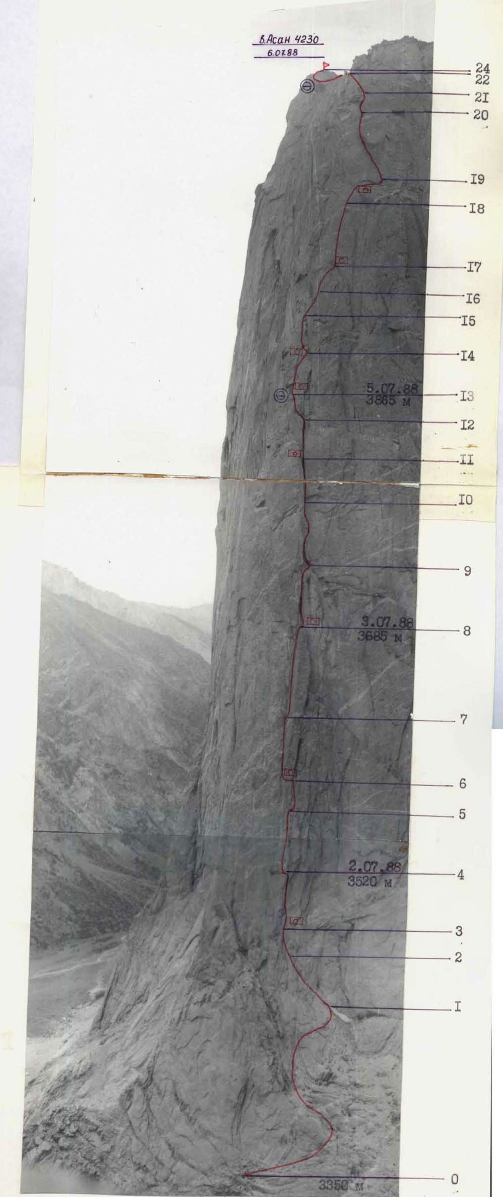
Photo 5. Technical photography. Date and time of shooting — July 4, 1988 11:00. Lens — "Volna 3M" (80 mm). Shooting point — № 1. Distance — about 600 m.
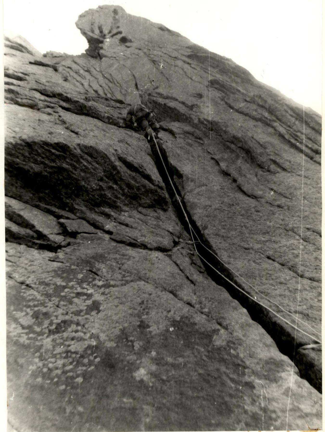
Photo 15. Section R13–R14. Crack. Work of the 1st. Date and time of shooting — July 6, 1988 11:10. Lens — "Helios 44A" (58 mm). Shooting point — R13 — overnight stay location.