St. Petersburg Alpine Climbing Championship
High-altitude technical class
2022
Report
On the first ascent
to the summit of Peak Ostry 4818 m via the center of the southeast wall, category 5B (proposed), by a team from St. Petersburg from August 4, 2022, to August 6, 2022.
I. Climbing passport
| 1. General information | ||
|---|---|---|
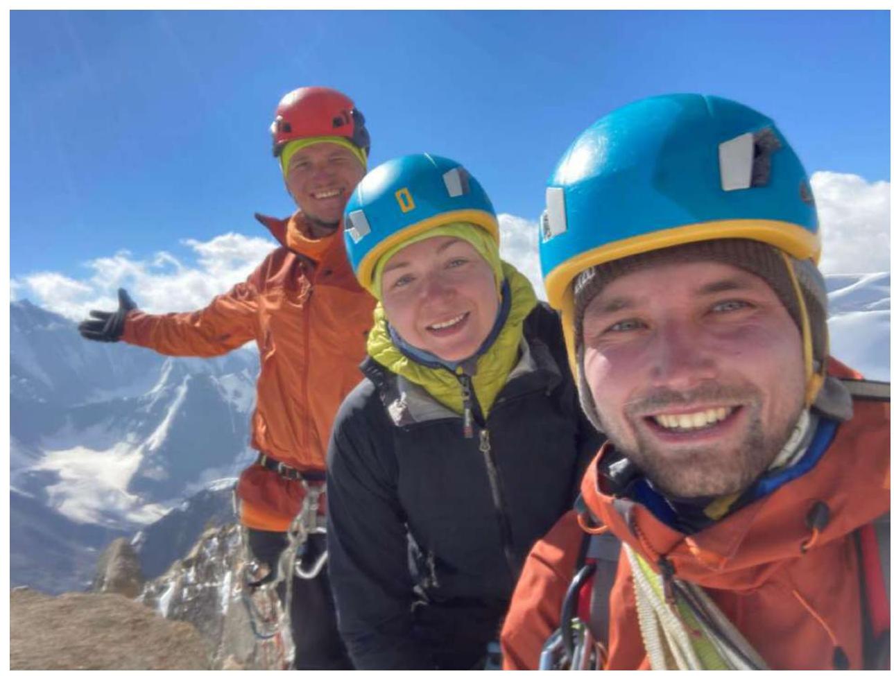
| 1.1 | Full name, sports rank of the leader | Ilya Mikhailovich Zhdanov, 1st sports rank |
| 1.2 | Full name, sports rank of participants | Anar Gadzhimurad ogly Demirov, 1st sports rank, Oksana Andreevna Kochubey, CMS |
| 1.3 | Full name of coach | Vladimir Alexandrovich Molodozhen, Tatyana Ivanovna Timoshenko |
| 1.4 | Organization | RSOO Federation of Alpinism of St. Petersburg |
| 2. Characteristics of the ascent object | ||
| 2.1 | Region | 5. Gissar-Alay |
| 5.4.2. Lyaylyak region | ||
| 2.2 | Valley | Ortochashma (Dukinek) |
| 2.3 | Section number according to the 2013 classification table | 5.4.2 |
| 2.4 | Name and height of the summit | Peak Ostry (4818 m) |
| 2.5 | Geographical coordinates of the summit (latitude/longitude), GPS coordinates | N 39.585894 E 70.129292 |
| 3. Characteristics of the route | ||
| 3.1 | Route name | via the center of the southeast wall |
| 3.2 | Proposed category of difficulty | 5B |
| 3.3 | Degree of route development | first ascent |
| 3.4 | Terrain type of the route | rock |
| 3.5 | Elevation gain of the route (altimeter or GPS data) | 608 m |
| 3.6 | Route length (in meters) | wall section — 645 m, ridge — 250 m, total — 895 m |
| 3.7 | Technical elements of the route (total length of sections with different difficulty categories, terrain type) | II cat. rock — 100 m, III cat. rock — 180 m, IV cat. rock — 110 m, V cat. rock — 145 m, VI cat. rock — 195 m, VI A1 — 65 m, VI A2/A2+ — 90 m, VI A3 — 10 m, total VI (climbing + aid climbing) — 360 m |
| 3.8 | Average slope of the route (°) | 43° |
| 3.9 | Average slope of the main part of the route (°) | 70° |
| 3.10 | Descent from the summit | Along the western ridge, then down the southwest wall towards Tro-Block pass. (5 sections of 50–60 m) |
| 3.11 | Additional route characteristics | No water on the wall section of the route |
| 4. Characteristics of the team's actions | ||
| 4.1 | Movement time (team's total climbing hours, in hours and days) | 22 h 40 min, 2.5 days |
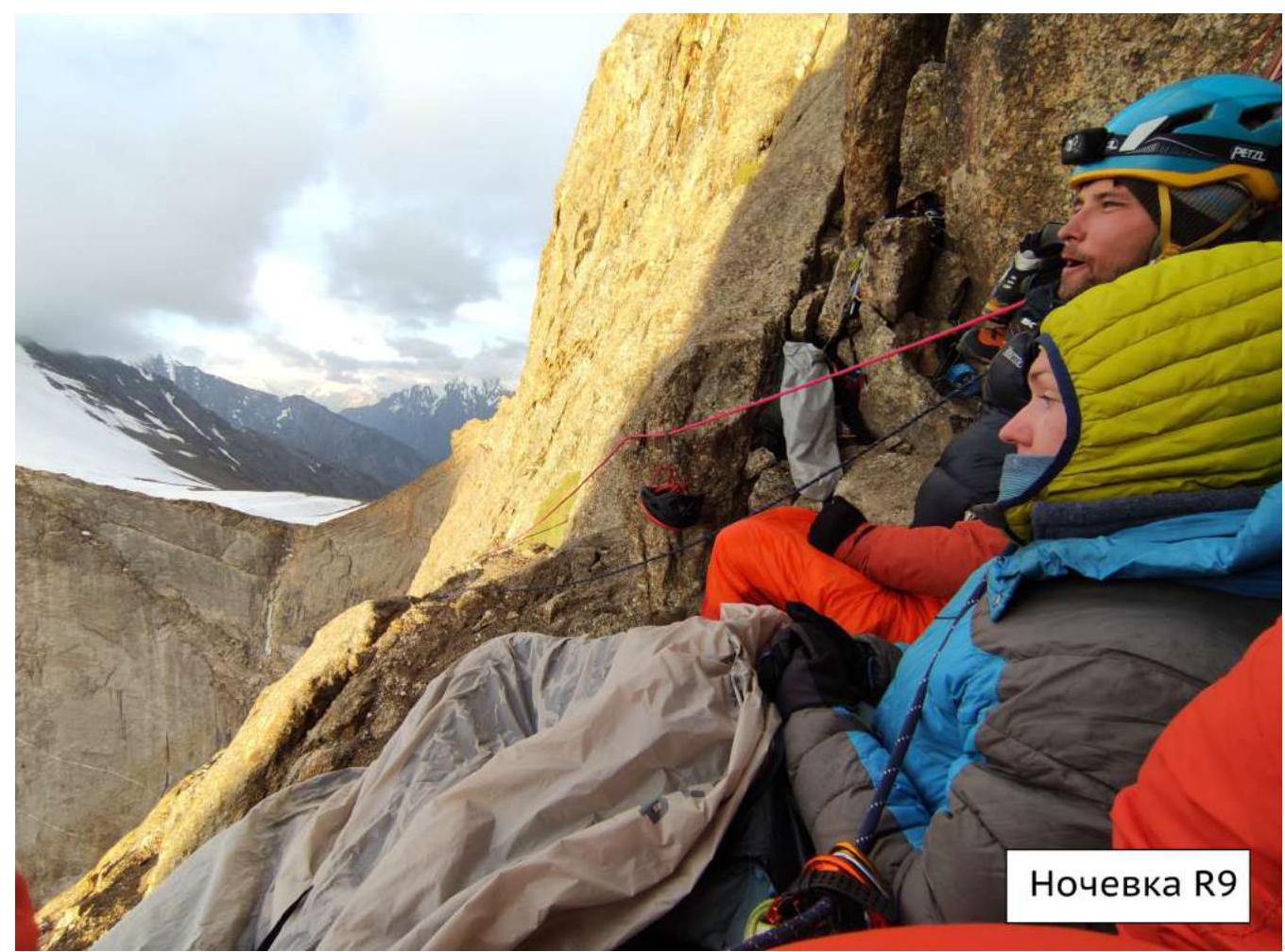
| 4.2 | Overnight stays | 1. Semi-reclining for 2 people and sitting for 1 person on R9. 2. In a tent on a good platform after a rappel in the middle of the ridge R18–R19. |
| 4.3 | Route preparation time | Not prepared |
| 4.4 | Start of the ascent | 8:00 August 4, 2022 |
| 4.5 | Summit attainment | 9:30 August 6, 2022 |
| 4.6 | Return to base camp | 15:00 August 6, 2022 |
| 5. Weather conditions | ||
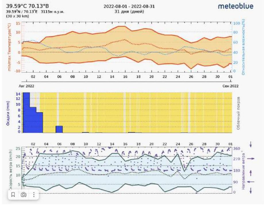
| 5.1 | Temperature, °C | from –5 °C to +10 °C |
| 5.2 | Wind speed, m/s | Gusts up to 15 m/s during precipitation |
| 5.3 | Precipitation | Snow with rain and wind on sections R15–R18 for about 2 hours in the second half of the day on August 5, 2022 |
| 5.4 | Visibility, m | About 100 m during precipitation |
| 6. Person responsible for the report | ||
| 6.1 | Full name, e-mail | Oksana Andreevna Kochubey, okskochubei@yandex.ru |
General photo of the route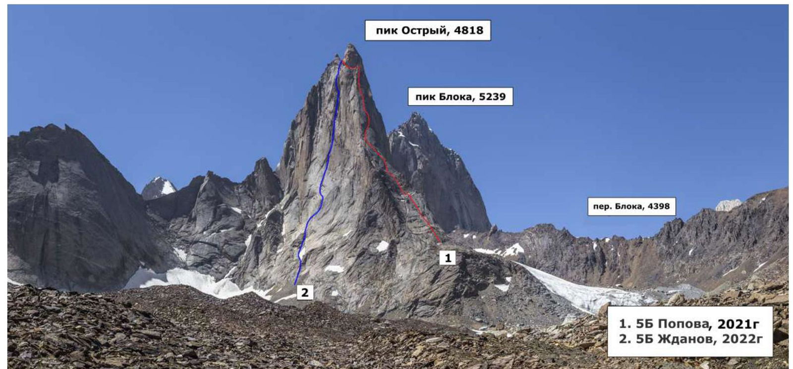
Photo by S. Romanenkov, taken during a mountain trip in July 2019, shooting height 4100 m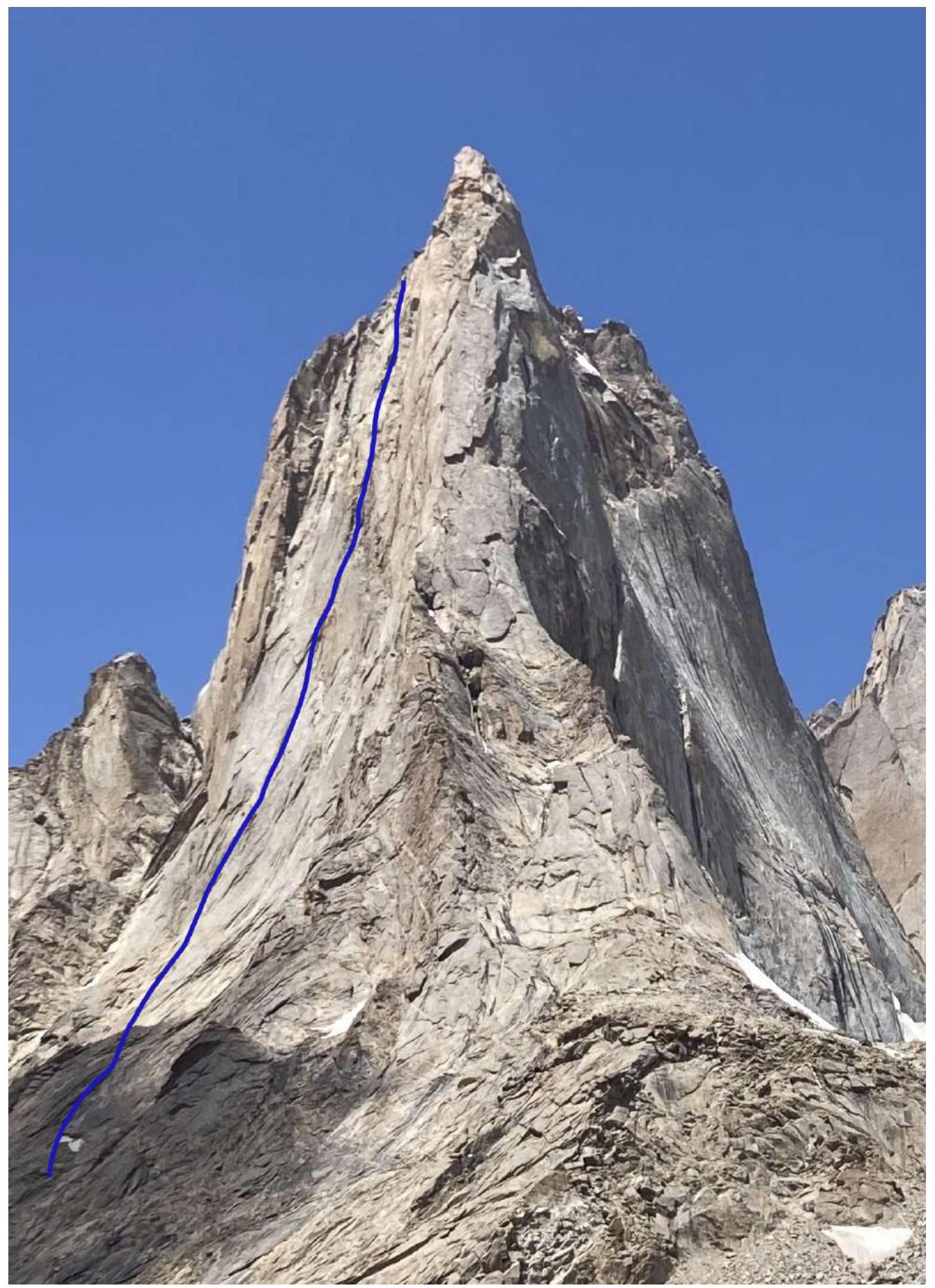
Photo of the route profile
Drawn profile of the route

Ascent description
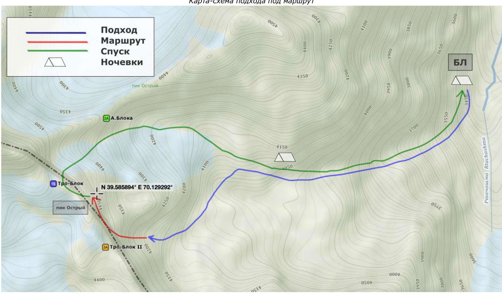
The Ortochashma river valley is located between the Karavshin and Lyaylyak valleys in the south of the Kyrgyz Republic. Near Peak Ostry are the well-known walls: Peak Aksu (5217 m), Peak Blok (5239 m), and Peak Piramidalny (5509 m).
The approach to the valley took the team two full days. It is possible to drive to the starting point (N39.76387 E70.34037) and from the Batkene settlement by jeeps via a pass on a rough serpentine road.
Further movement is only possible on foot or by horse. We rented two horses to transport over 180 kg of cargo, designed for 3 weeks of autonomous living in the valley. The equipment that the horses could not carry was carried in backpacks.
From the same place, the trail starts into the Karavshin valley, but after a couple of hours of walking, our trail turns right, along cattle trails along the Ortochashma river. Two bridges on the river were washed away this year. In one place, it was necessary to set up a crossing, and in another, to ford. The bridges were rebuilt on the return journey.
Along the river valley, it is necessary to reach the confluence of the Aktyubek river and the Dekenek river, which give rise to the Ortochashma river. From here, follow the right tributary — the Dekenek river (if you look downstream, it's the left one).
Further on the right bank (along the river flow) is a wide terrace, and on the left bank is a squeeze. The trail crosses to the right bank along a thick log, then you need to move along the right terrace of the Dekenek river, where there is a good trail, cows graze, and there is a shepherd's hut where a shepherd lives seasonally. If you befriend him, you can:
- exchange flatbreads for tea;
- recharge his battery;
- possibly arrange for a sheep.
Further, the trail turns into a circus leading to the Tro-Block pass, immediately after the end of the squeeze. There used to be a bridge here, but it was washed away this year. At the turn into the circus of Peak Ostry, we set up a base camp at an altitude of 3400 m (N39.60757 E70.16510). But if you plan to stay in the valley for a long time, it's better to set up a camp in the forested part of the meadow, 20 minutes earlier.
Next, from the base camp, turn towards Peak Ostry (it's visible from the valley) along the path to the right into the circus. It's better to climb along the left gully, where there is a grassy slope, местами курумник. We set up a storm camp at 4100 m, near a stream originating from a glacier leading to the Tro-Block descent pass.
Map-scheme of the area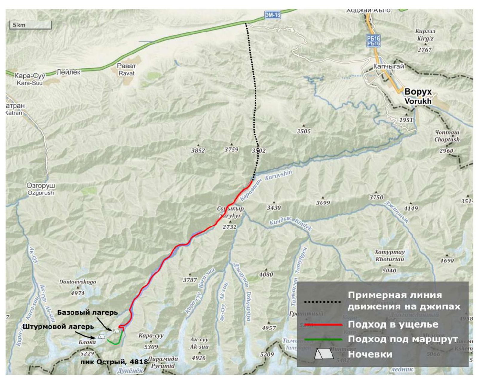
Currently, there is one route to Peak Ostry in the FFA database:
- Popova M. E. 5B via the v. kf., 2021.
Our route goes through the center of the southeast wall, to the left of Popova's 5B route (via the eastern counterfort).
The route can be conditionally divided into two parts:
Wall:
- The route begins along a large internal corner that leads to a ledge, from which the steep part of the wall begins.
- Further, the route follows a series of internal corners to a good ledge (overnight stay possible under one tent – R4).
- After the ledge, following the terrain, the route leads to another less convenient ledge (semi-reclining overnight stay possible – R7).
- Next is the key section of the route (R7–R8):
- Initially, left and up along an internal corner.
- Then a difficult traverse to the right.
- And then up along difficult terrain (R8–R9), which leads us to a destroyed belt and a platform for a semi-reclining overnight stay (R9).
- Further, the route goes slightly to the left along logical terrain.
- It starts with a large internal corner, then through a series of blocks, flakes, and cracks, it leads under the cornice in the upper part of the wall.
- Having passed the cornices (second key section R14–R15), we reach a section of monolithic cracks, which then turn into an internal corner and lead to the ridge.
Ridge: the ridge is not difficult and is almost entirely traversed by simultaneous climbing. On a couple of sections, there were fixed ropes. There is a loop before a large gendarme, from which a 30 m rappel can be made to a ledge where our overnight stay was. Alternatively, a 15–20 m rappel can be made and continue moving along the ridge to the summit.
Weather conditions and ascent schedule
Peak Ostry, 4810 m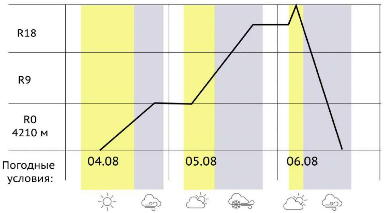
Approach map-scheme
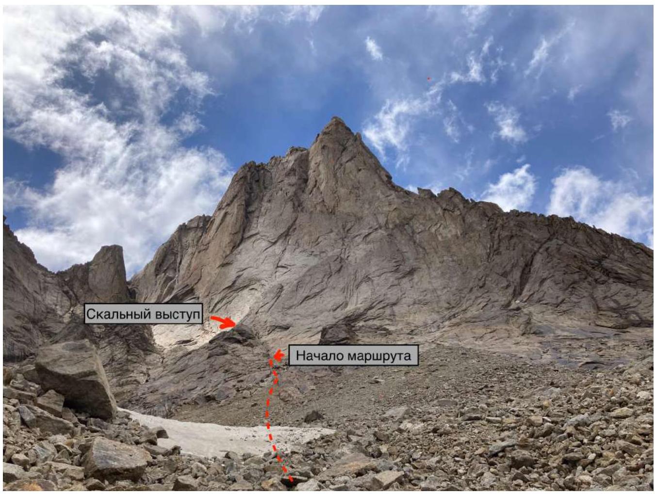
Technical photo of the route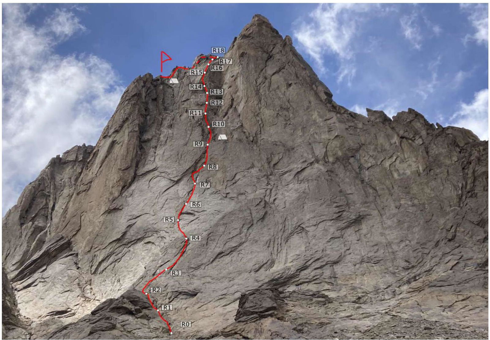
Approach:
- From the parking near the moraine lake, proceed a bit upstream (100–150 m).
- At a convenient location, climb up to the left moraine.
- Then move along the moraine hills, trying not to gain altitude, under the middle of the base of the southeast wall.
- Under the wall, there is a possibility to reach a stream where water can be collected for the ascent.
- From there, ascend in the direction of the start of the route along small and medium talus.
- The big internal corner serves as a landmark for the start of the route.
- The corner leads from right to left towards the top of a huge rock outcrop.
R0–R1 (50 m, III): Along the large internal corner-couloir that veers left. R1–R2 (30 m, III): Along simple terrain, veering slightly left to a ledge. R2–R3 (40 m, V): First along the right internal corner, then a small transition along the wall to the left and up along the internal corner and ridges. R3–R4 (40 m, 6A): Along the left internal corner to a good ledge (overnight stay possible). R4–R5 (35 m: 20 m, 6A; 15 m, A2): Up a wet corner and slabs. In the cracks, there is wet moss. R5–R6 (35 m: 20 m, 6A; 15 m, A1): Along slabs and a wet black chimney upwards. R6–R7 (35 m: 20 m, 6A; 15 m, A2): Along an internal corner, partly turning into a black chimney upwards to a ledge where a semi-reclining overnight stay is possible. R7–R8 (35 m: 25 m, A2; 10 m, A3): Slightly left, crossing a large black streak along a small wet internal corner filled with earth, to large slab-like outcrops. Then a difficult traverse to the right along slab-like outcrops. R8–R9 (35 m: 20 m, A2; 15 m, A1): Up along resonating outcrops and overhangs to a flattening. From there, slightly right and up under the wall where a semi-reclining overnight stay is arranged. R9–R10 (35 m, V): From the overnight stay, left and up along a large internal corner formed by large blocks and outcrops. R10–R11 (35 m, V): Slightly left, following the terrain upwards along slabs and blocks. R11–R12 (30 m: 10 m, A1; 20 m, 6B): Through a small overhang up along an internal corner and cracks. R12–R13 (35 m, 6A): Up along an internal corner and cracks to outcrops at the base of the right internal corner. R13–R14 (35 m: 25 m, 6A; 10 m, A1): First along an internal corner, then a traverse to the left to cracks, then up and left in the direction of the corner under a large cornice. R14–R15 (45 m: 15 m, A2; 15 m, A1; 15 m, 6C): Pass the cornice upwards, then slightly right and up under another cornice with unreliable rock. Then through the cornice upwards, we reach a narrow monolithic crack. Up along the crack, then a transition to a wider crack on the left and climbing along it. R15–R16 (35 m, V): Up along an internal corner. In some places, there is ice in the cracks. R16–R17 (35 m, IV): Traverse to the right, then up first along the wall, then along an internal corner to the left and up. R17–R18 (25 m, IV): Up to the ridge along simple terrain. R18–R19 (250 m: 100 m, II; 100 m, III; 50 m, IV): Left along the ridge towards the summit. Before the gendarme, a rappel down 30 m (there is a loop) to a ledge for overnight stay. A small tent can be set up. If overnight stay is not needed, a 15–20 m rappel and continue along the ridge towards the summit.
Route scheme in UIAA symbols
(counting of protection placements not conducted)
| Section | Length | Difficulty |
|---|---|---|
| R8–R9 | 35 m | VI, A2, A1 |
| R7–R8 | 35 m | VI, A2+, A3 |
| R6–R7 | 35 m | 6A, A2 |
| R5–R6 | 35 m | 6A, A1 |
| R4–R5 | 35 m | 6A, A2 |
| R3–R4 | 40 m | 6A |
| R2–R3 | 40 m | V |
| R1–R2 | 30 m | III |
| R0–R1 | 50 m | III |
Route scheme in UIAA symbols
(counting of protection placements not conducted)
| Section | Length | Difficulty | |
|---|---|---|---|
| R17–R18 | 25 m | IV | |
| R16–R17 | 35 m | IV | |
| R15–R16 | 35 m | V | R16 |
| R14–R15 | 45 m | A2, A1, 6C | R15 |
| R13–R14 | 35 m | 6A, A1 | |
| R12–R13 | 35 m | 6A | |
| R11–R12 | 30 m | 6B, A1 | |
| R10–R11 | 35 m | V+ | |
| R9–R10 | 35 m | V |
Team actions
By the start of the ascent, bad weather had persisted in the valley for 6 days. According to the forecast (received via Garmin InReach), precipitation was expected with a probability of 30% on the planned ascent days.
On August 4, 2022, at 6:30, we left the storm camp with a supply of food and water for 3 days. By 7:30, we reached the base of the route. The weather was clear. At 8:00, the leader started working on the route. The first two ropes were climbed with three people. Then followed complex climbing along internal corners and ridges. There is a good spot for overnight stay on R4. From above, small pieces of ice occasionally fell.
By 16:00, the leader reached an internal corner that was partly filled with wet moss. The ropes with aid climbing (R5) began, interspersed with complex climbing. To the right were slabs that were not appealing to climb. The route continued through a series of cracks and black chimneys. It was partly wet and featured complex climbing and aid climbing. The terrain led to a small ledge R7, where a semi-reclining overnight stay was possible. From here, the first key section of the route began.
At 19:00, the leader started traversing the difficult section R7–R8, then a cornice, which after complex and unreliable terrain led to a ledge (the supposed overnight stay location). A strong wind picked up, and it grew colder. At 20:30, the leader reached the ledge R9, and by 21:30, the entire team had gathered on the ledge to set up a semi-reclining (2 places) and sitting overnight stay. The weather was clear.
On August 5, 2022, at 9:00, the leader resumed work on the route. The weather was sunny, but the forecast indicated it would worsen by evening. We followed a system of internal corners and cracks under the cornices. The second key section R14–R15 featured unusual rock resembling marble under the lower cornice and quartz on the second. By 14:00, the group reached slabs with monolithic cracks. Initially, aid climbing was used along a thin crack, then a transition to a wider crack on the left. The climbing here was beautiful and complex.
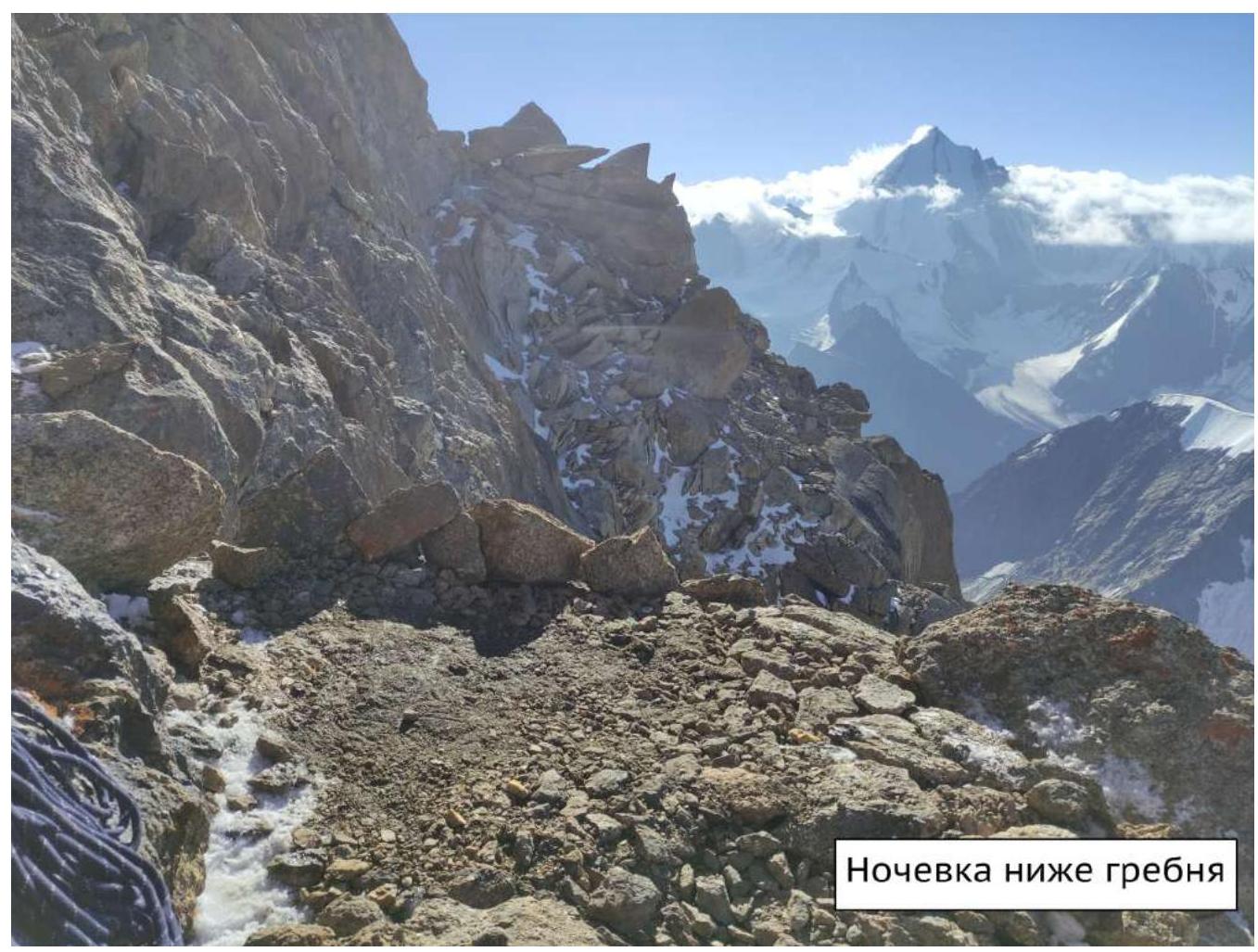
The weather deteriorated. A blizzard and strong wind ensued. The leader climbed along an internal corner, partly with ice, then traversed right along a narrow ledge R16. Further up along a large internal corner and strongly destroyed terrain, the group reached the ridge at 17:00. Movement continued towards the summit. The weather did not improve, and it was decided to set up a second overnight stay. The group found a flat spot 30 m below the ridge and began preparing a site for overnight stay at 19:00.
On August 6, 2022, we started at 8:50. The summit was reached in an hour. The weather was good.
Descent:
- From the summit to a ledge in the direction of Tro-Block pass, 55 m. There is a loop.
- Then descend slightly on foot along gentle terrain (20–30 m), from there slightly left to a loop on a закладка in a crack.
- From there, 15 m to a loop on the left, closer to the edge of the ridge (left by Popova's team). Our descent continues to the left of the ridge as we planned to descend to the pass.
- From there down 60 m to a larger flake. There is a loop on it.
- Then 55 m to a slab with an anchor and a loop.
- From there, 50 m to ledges at the base of the wall.
- Then on foot to the pass, 10 minutes.
Descent scheme:
For the descent, 2 dynamic and 2 static single ropes of 60 m were used. The movement technique was simultaneous "Krasnoyarsk" style.
The second participant moved along a fixed rope with a cow's tail and used a Gri-Gri for belaying the leader and themselves.
The third participant with a backpack moved along a fixed static rope, belaying themselves with a Gri-Gri on a fixed dynamic rope.
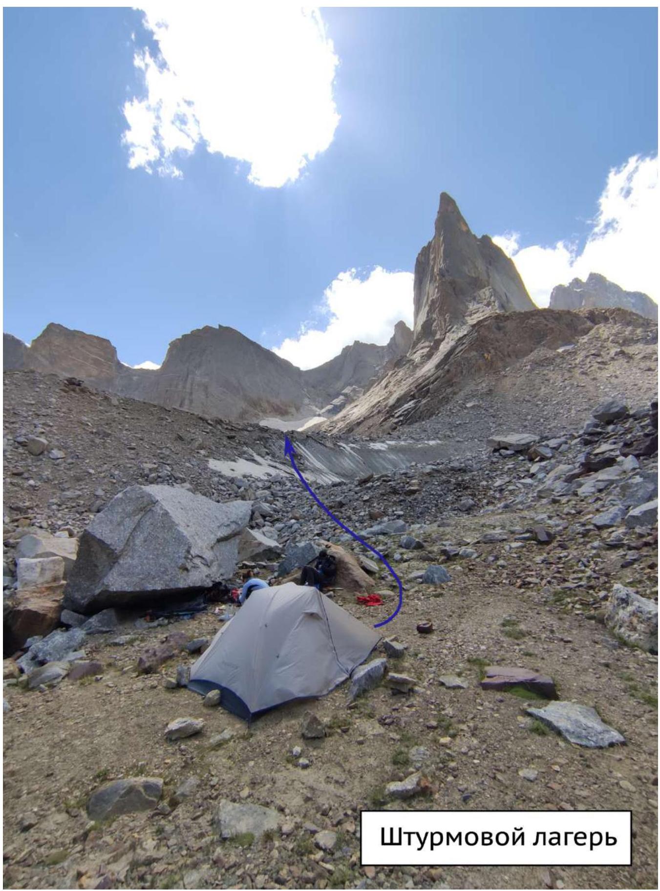
Storm camp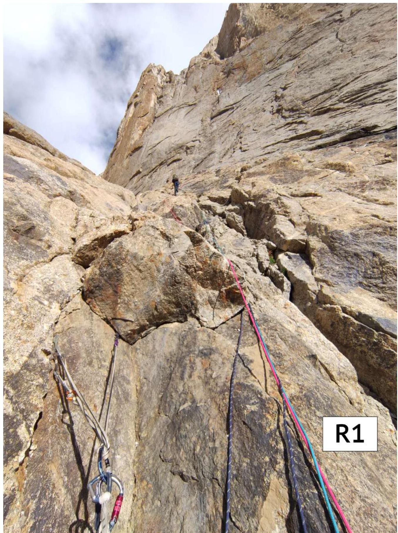
R1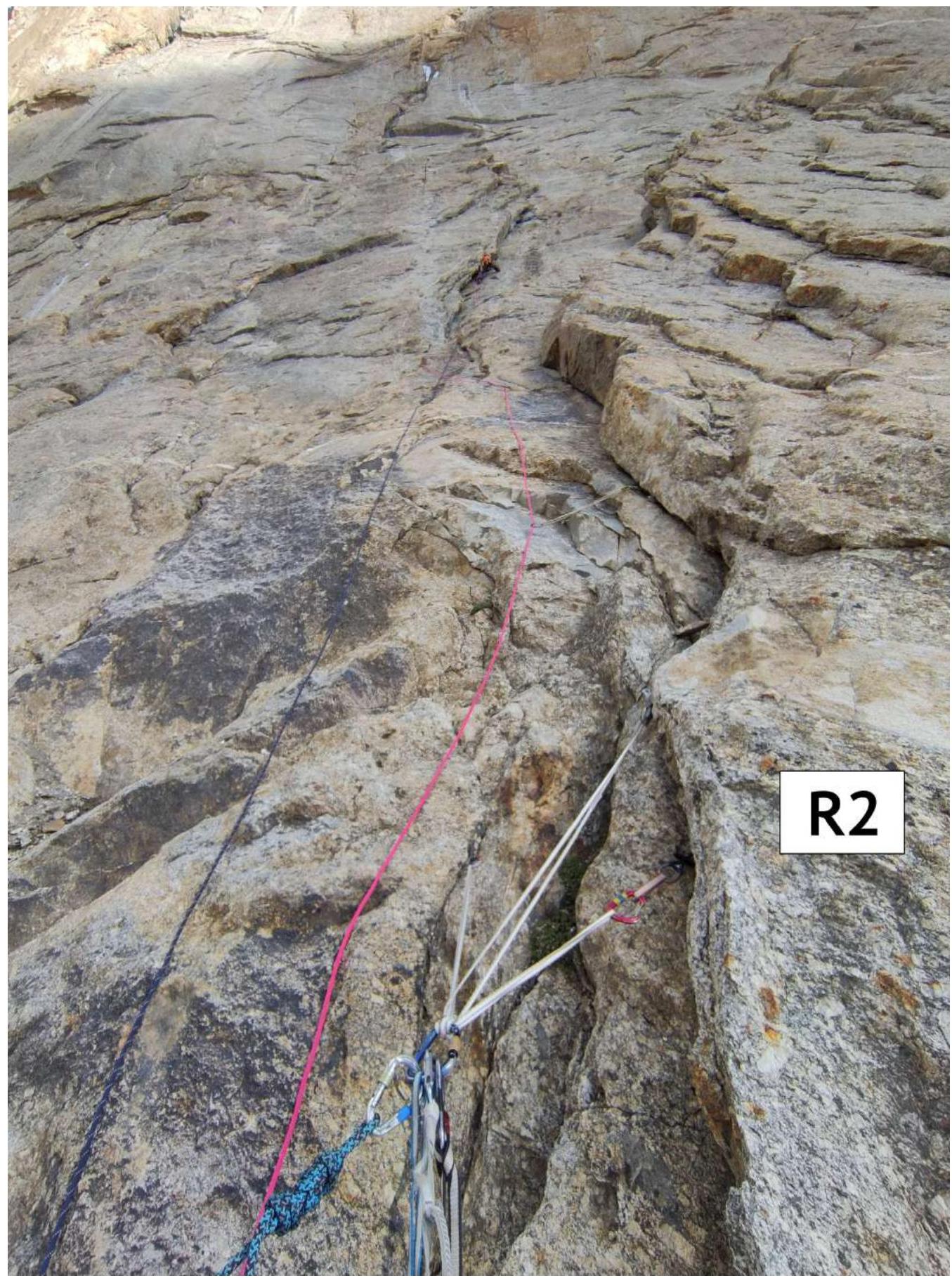
R2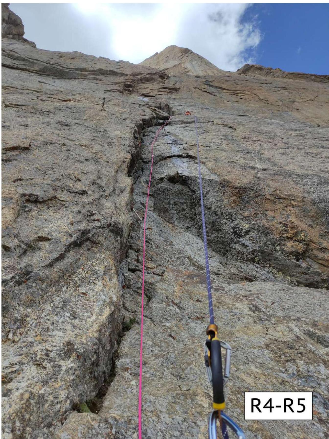
R4–R5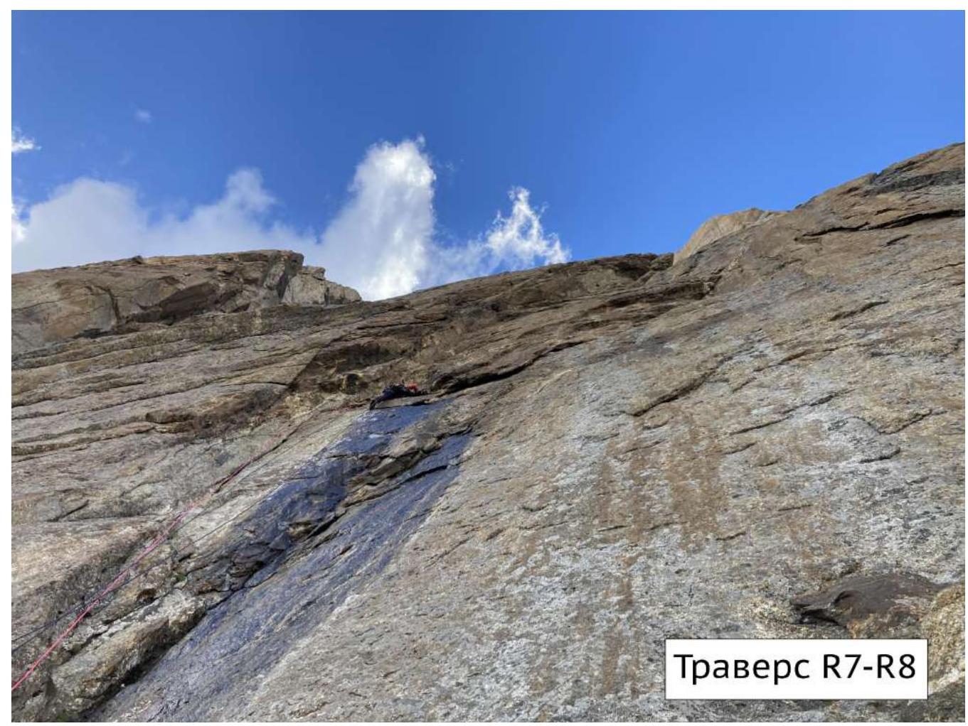
Overnight stay R9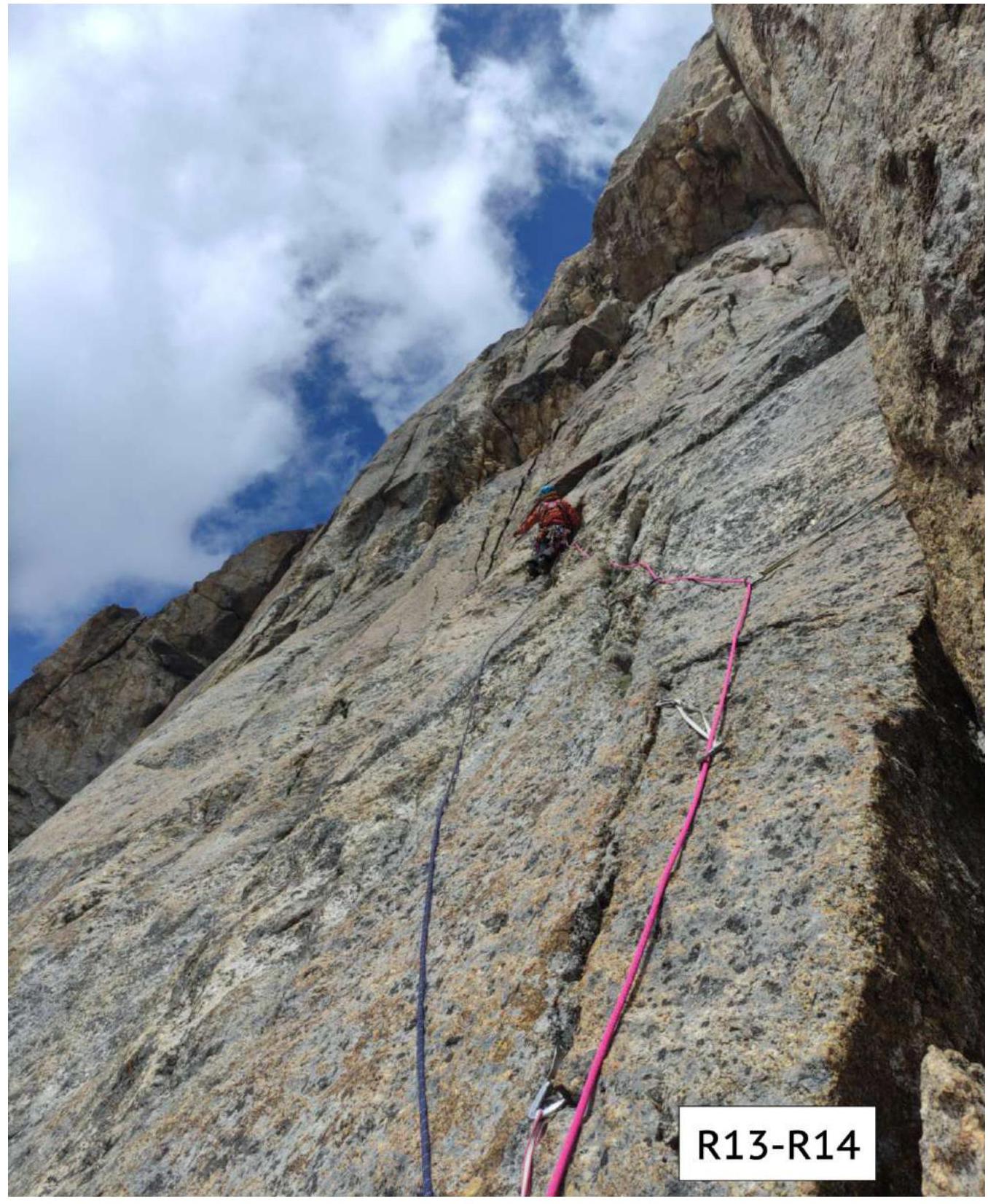
R13–R14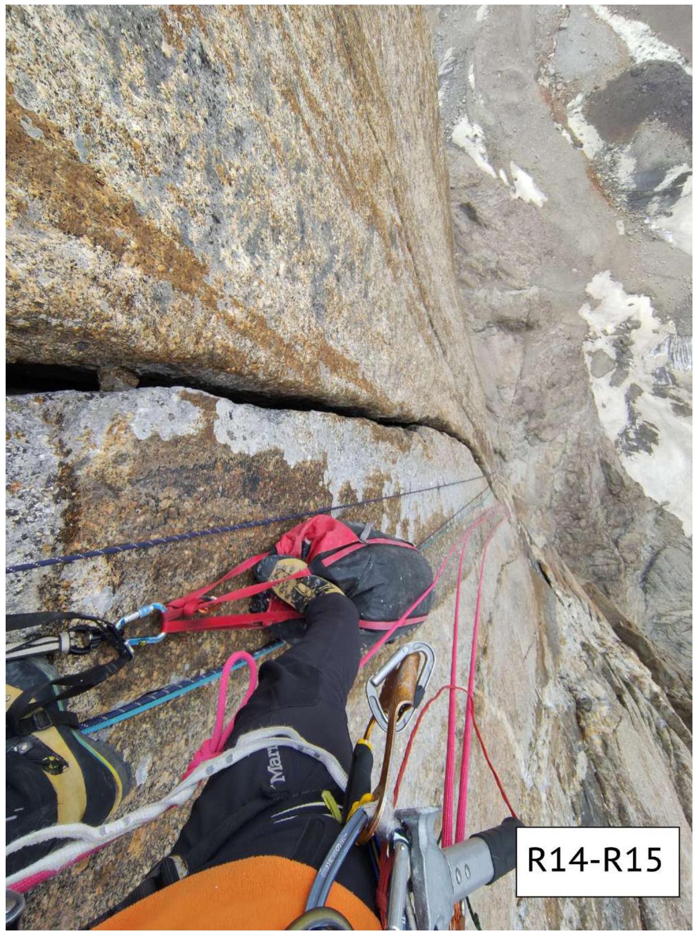
R14–R15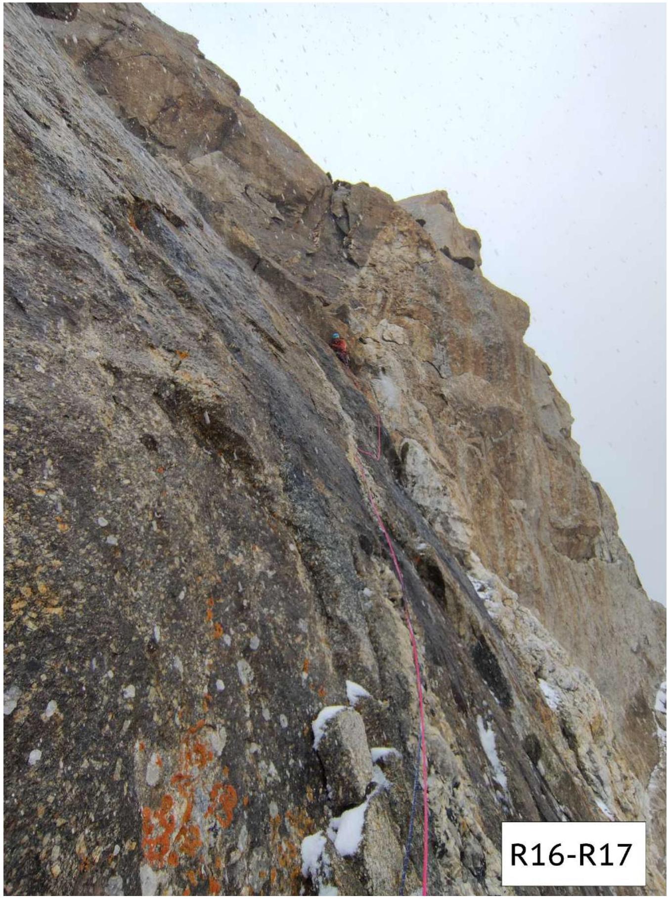
R16–R17
Ridge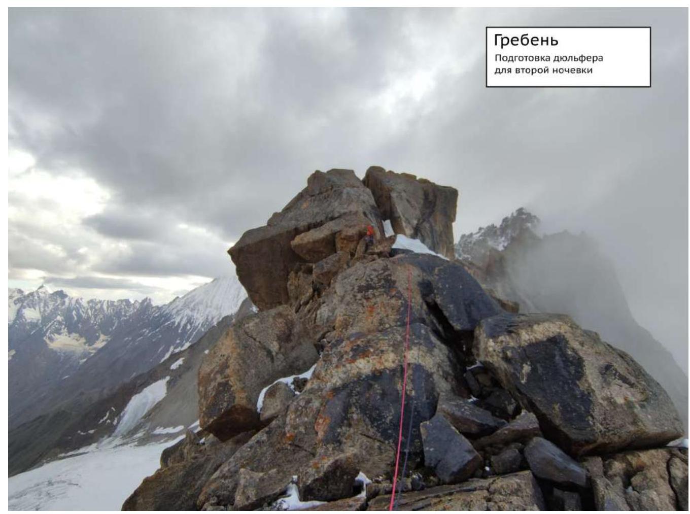
Popova's team's note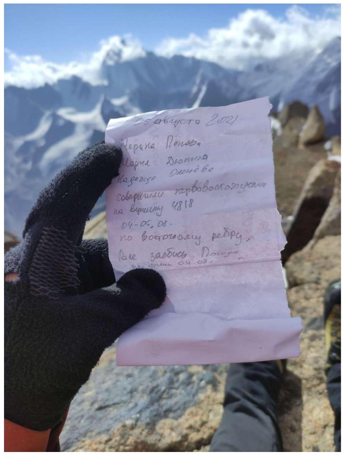
3.3. Safety assessment of the route. Recommendations for subsequent climbers.
We consider the route we took to be logical, fairly safe, and interesting. No rockfall was observed during our observation and passage of the route. In the lower part, small pieces of ice occasionally fell. The approach is not complicated. There is no water on the wall. By its nature and complexity, the route is more challenging than the usual 5B routes in the area and is closer to 6A, which should be taken into account by subsequent climbing groups.
Most of the route is done with free climbing in rock shoes. The terrain for protection is good. There are also fairly long sections of aid climbing. The key sections of the route are R7–R8 and R14–R15. On section R7–R8, the traverse with aid climbing A3 goes along large slab-like outcrops that do not look very safe. Also, on section R8–R9, there are sections of complex aid climbing A2 on not very reliable terrain. The second part of section R14–R15 along the left crack is very beautiful and complex crack climbing — 6C.
Good overnight stay locations are possible on the ledge R4, as well as in the middle of the ridge after a rappel (team's overnight stay). Semi-reclining overnight stays are possible on ledges:
- R7;
- R9.
Equipment recommendations: a set of protection gear, anchor hooks, rock pitons, rock shoes. Two steps were made on relief skyhooks, but it's possible to do without them using pitons and anchors. Bolt equipment was not needed. With good route conditions and favorable weather, crampons are not necessary. Two 60 m ropes will be needed for the descent.
For weather updates and emergency communication, a GPS messenger Garmin InReach was used.