Report
On the first ascent of the peak 4818 m (Peak Ostroy) via the route 5B cat. diff. by a team from Krasnoyarsk and Perm regions from August 4 to 5, 2021
I. Climbing Report
| 1. General Information | ||
|---|---|---|
| 1.1 | Full name, sports rank of the team leader | Popova Marina Evgenievna, MS |
| 1.2 | Full name, sports rank of participants | Dyupina Maria, MS, Oleneva Nadezhda, MS |
| 1.3 | Full name of coach | Balezın Valery Viktorovich, MSMK, Zakharov Nikolay Nikolaevich, MSMK, Prokofiev Denis Evgenievich, MS |
| 1.4 | Organization | Krasnoyarsk Regional Federation of Mountaineering — Perm Regional Youth Public Organization — Federation of Mountaineering and Rock Climbing |
| 2. Characteristics of the Climbing Object | ||
| 2.1 | Region | 5. Gissar-Alay 5.4.2. Lyaylyak region |
| 2.2 | Valley | Ortochashma |
| 2.3 | Section number according to the 2013 Classification Table | 5.4.2. |
| 2.4 | Name and height of the peak | Peak Ostroy, 4818 m |
| 2.5 | Geographical coordinates of the peak (latitude/longitude), GPS coordinates | N 39.585895 E 70.129268 |
| 3. Characteristics of the Route | ||
| 3.1 | Name of the route | Via the Eastern counterfort |
| 3.2 | Proposed category of difficulty | 5B |
| 3.3 | Degree of route exploration | First ascent |
| 3.4 | Nature of the route terrain | Rock |
| 3.5 | Height difference of the route (altimeter or GPS data) | 550 |
| 3.6 | Route length (in meters) | 1020 m, 620 m of wall section |
| 3.7 | Technical elements of the route (total length of sections of varying category of difficulty with indication of terrain type (ice-snow, rock)) | II cat. diff. rock — 90 m, III cat. diff. rock — 460 m, IV cat. diff. rock — 150 m, V cat. diff. rock — 40 m, VI cat. diff. rock — 180 m, Rock VI, A1–A2 — 80 m, Rock VI, A3 — 20 m |
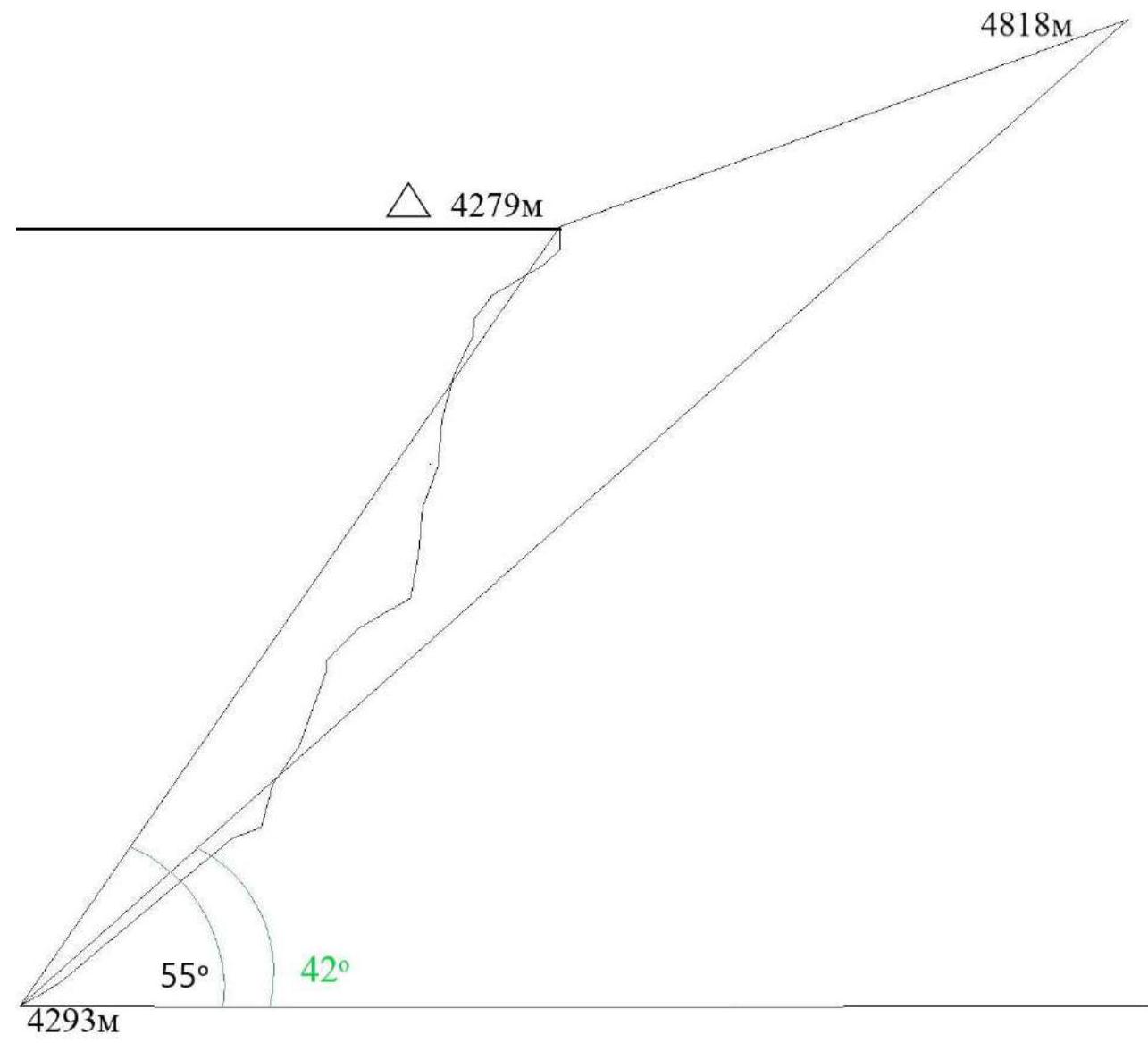
| 3.8 | Average slope of the route, (°) | 42 |
| 3.9 | Average slope of the main part of the route, (°) | 55 |
| :--: | :--: | :--: |
| 3.10 | Descent from the summit | Via the western ridge towards the Tro-Block pass (8 rappels of 50–60 m) |
| 3.11 | Additional route characteristics | Water in the form of snow on the ridge, no snow/water on the wall |
| 4. Characteristics of Team Actions | ||
| 4.1 | Time of movement (team's walking hours, indicated in hours and days) | 16 hours, 1.5 days |
| 4.2 | Overnight stays | On the ridge in a tent |
| 4.3 | Time spent processing the route | - |
| 4.4 | Departure onto the route | 04.08.2021 6:00 |
| 4.5 | Arrival at the summit | 05.08.2021 12:00 |
| 4.6 | Return to the base camp | 05.08.2021 20:30 |
| 5. Characteristics of Weather Conditions | ||
| 5.1 | Temperature, °C | −1 to +8°C (during the day) |
| 5.2 | Wind speed, m/s | Gusts up to 15 m/s (during precipitation) |
| 5.3 | Precipitation | Snow/snow grains with strong wind lasting from 30 to 70 minutes on August 4 at around 9:00, 11:40, 14:00, and 17:30; precipitation only on descent from the summit on August 5 |
| 5.4 | Visibility, m | 15 m to 100 m during bad weather |
| 6. Person Responsible for the Report | ||
| 6.1 | Full name, e-mail | Popova Marina Evgenievna |
II. Climbing Description
1. Characteristics of the Climbing Object
1.1. General Photo of the Peak
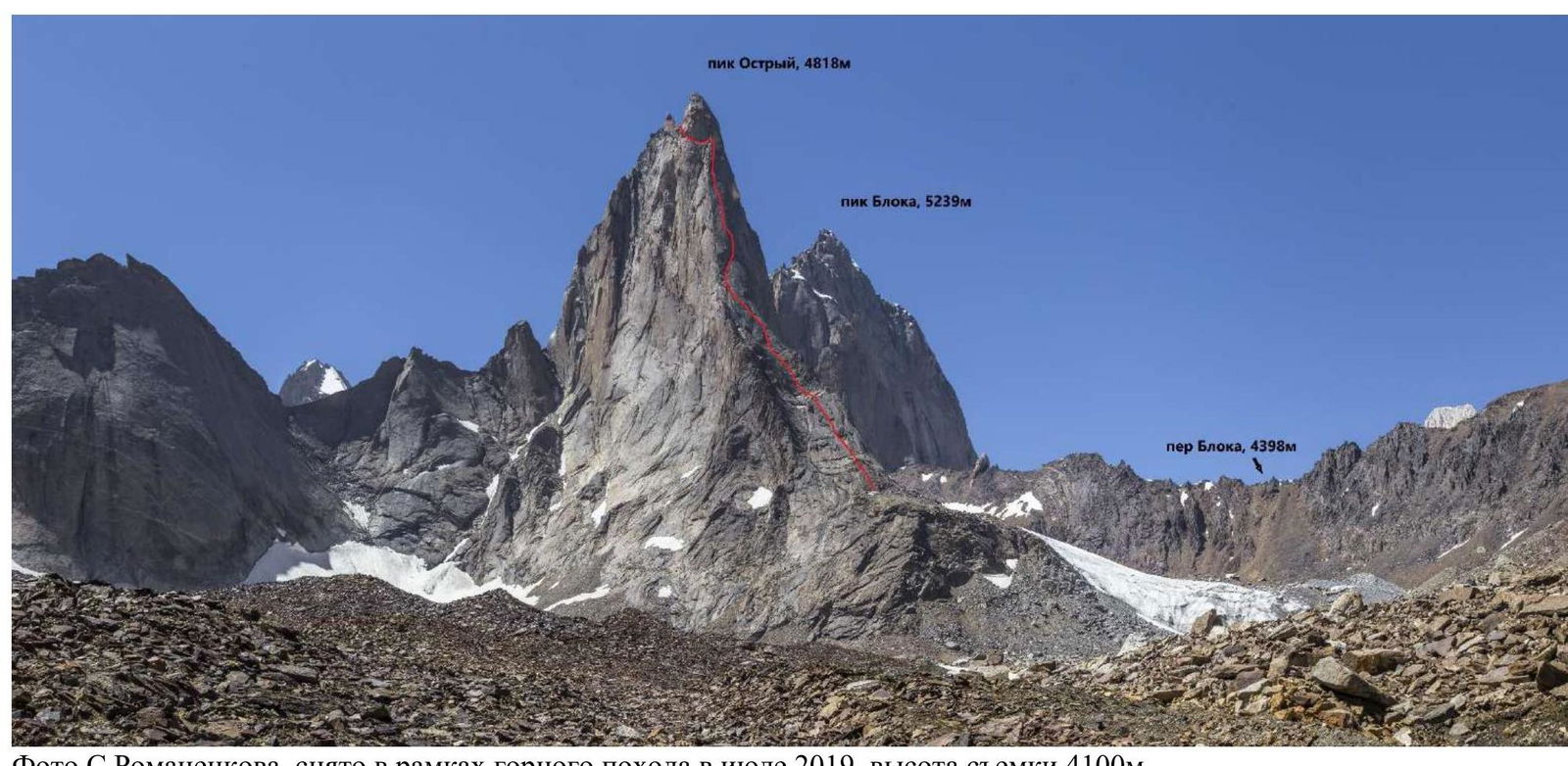
Photo by S. Romanenkov, taken during a mountain trip in July 2019, shot at 4100 m.
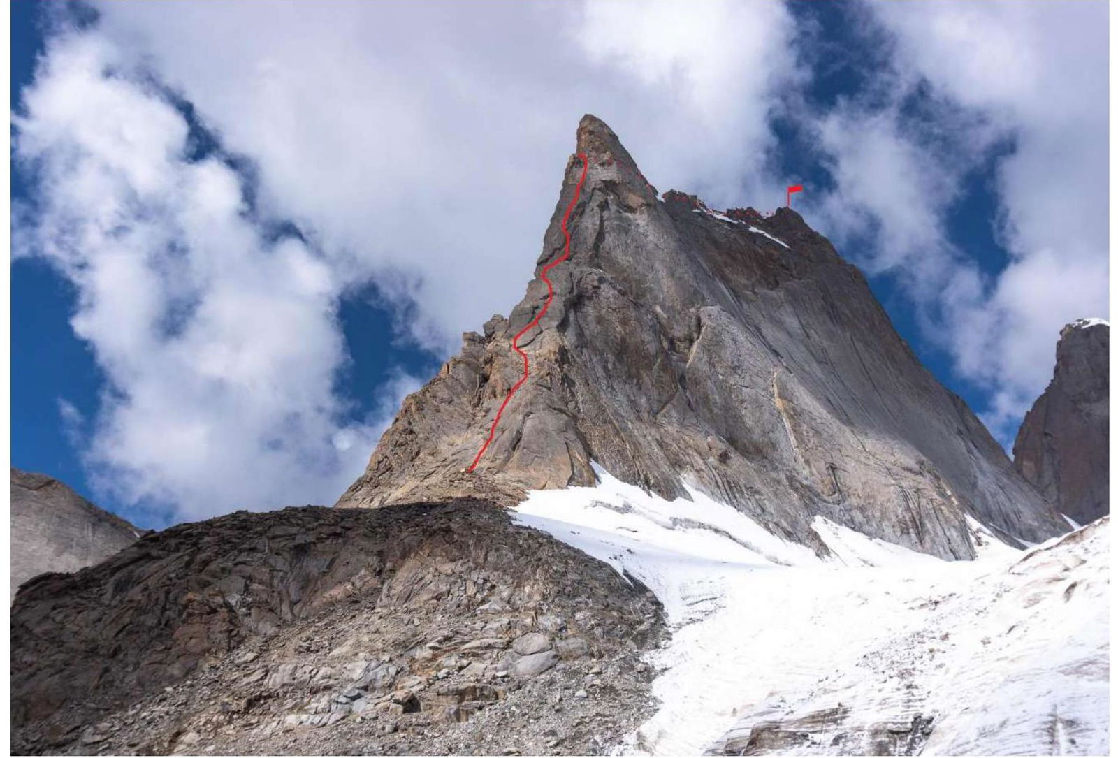
1.2. Photo of the Route Profile
1.3. Drawn Profile of the Route
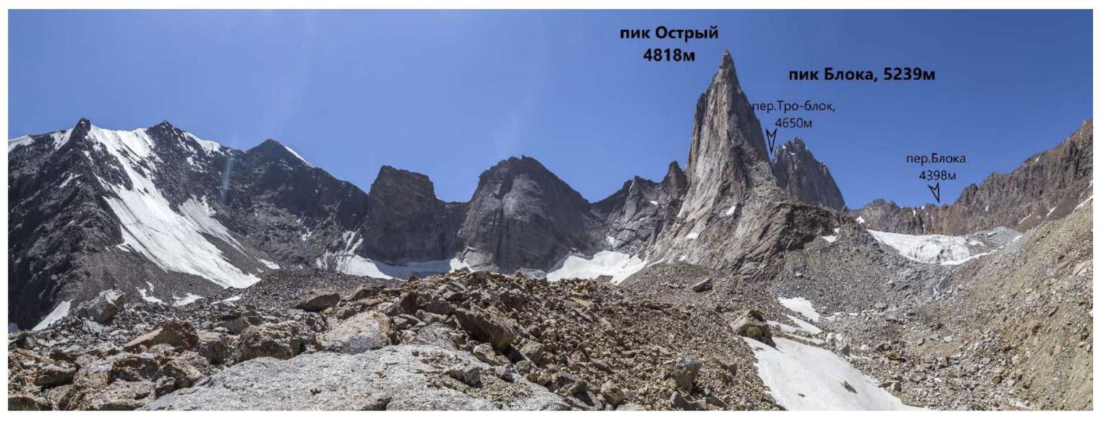
1.4. Photopanorama of the Area
1.5. Map of the Area
Peak 4818 is located in the upper reaches of the Ortochashma valley. We reached the valley from Karavshin. The transition from the Karavshin base camp took a full daylight day, approximately 20 km (goods were carried by horses). At 8:00 AM, we departed from Karavshin and established our base camp by 20:30. The red line on the map indicates our path from Karavshin, and the blue line represents our descent along the Ortochashma river, which eventually connects with the "standard" road from Karavshin, leading to Vorukh or Saryaz.
Approach from Karavshin:
- Ascended to Karasu Pass (1A, 3720 m)
- Descended to the Koshmonok stream
- Ascended to Koshmonok Pass (n/k, 3260 m)
- Descended to the Ortochashma river
It is also possible to reach Ortochashma from Ozgherush via the passes Buldzhuma — Aktash — Dzhagachy, which is one of the standard approaches to Karavshin from Ozgherush. Ortochashma is roughly halfway, slightly closer to Karavshin.
Reached the confluence of Aktyubek and Dukenek, which form the Ortochashma river. We needed the right tributary — Dukenek (the left one when looking upstream).
Further along the right bank, there is a wide terrace, while the left bank has a cliff. The trail crosses to the right bank via a thick log, and then we continued along the right terrace of Dukenek. Here, the trail is good, cows graze, and there is a shepherd's hut. The turn into the cirque leading to the Tro-Block pass is immediately after the end of the cliff. Previously, there was a bridge here, but it was washed away this year. At the turn into the cirque of Peak Ostroy, we established our base camp at an altitude of 3400 m.
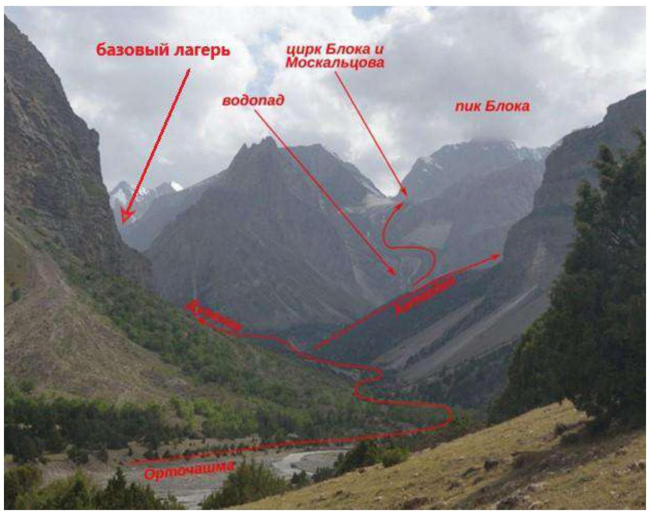
Ortochashma valley, general approach scheme to the base camp when approaching from Karasu. Photograph by Georgy Salnikov, 2016.
Further from the base camp:
- Turn towards Peak 4818 (visible from the valley) to the right into the cirque;
- Ascend via the left gully — a grassy slope, partially scree;
- Establish ABC camp at 4150 m near a stream originating from a glacier leading to the Tro-Block pass.
2. Characteristics of the Route
2.1. Technical Photograph of the Route
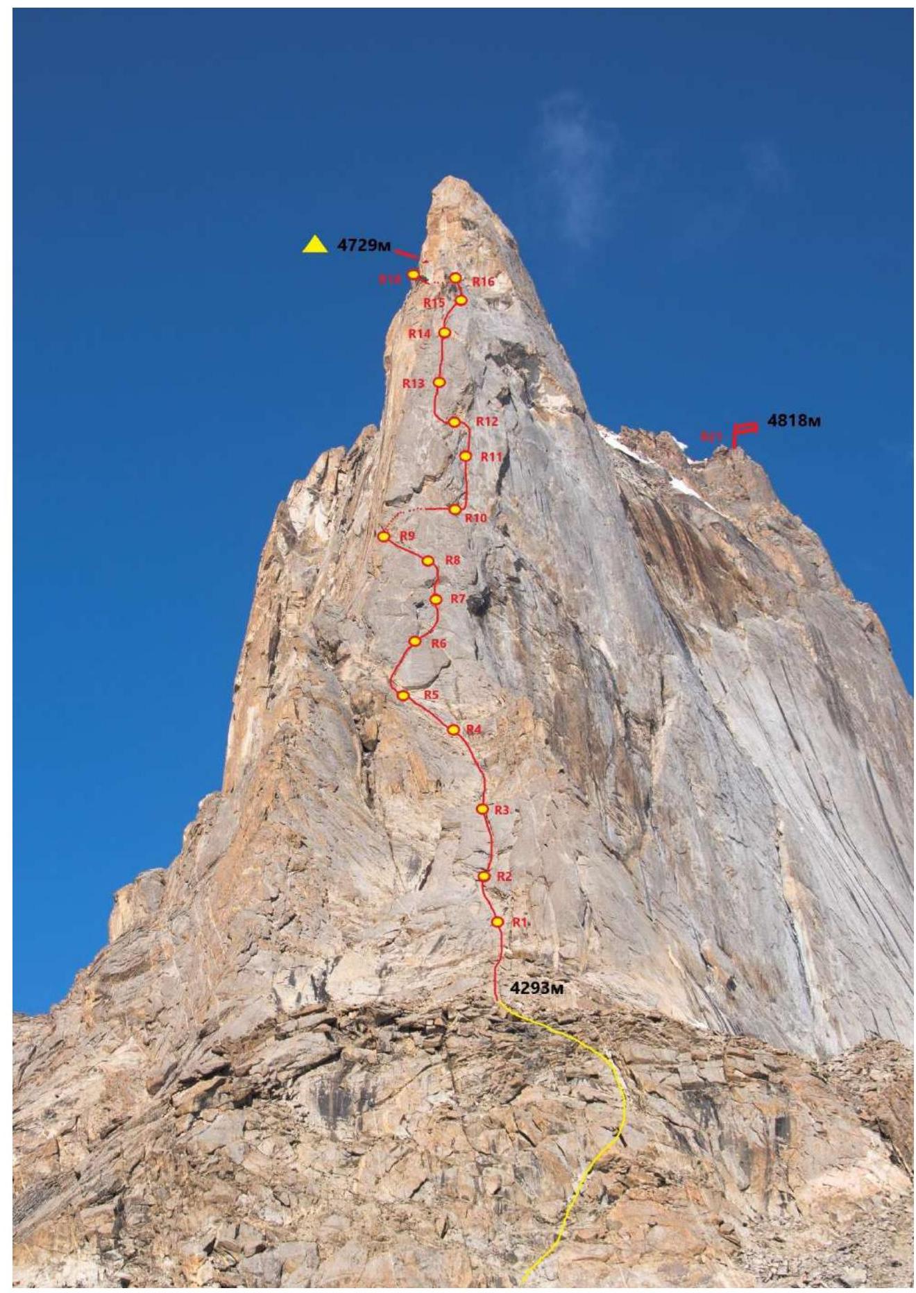
2.3. Route Diagram in UIAA Symbols

| Section # | Friends/ incl. ITO | Anchor hooks/ODI | ITO on fiffs, suzyunakh | Bolts | Insurance points, characteristics in symbols | Route line in UIAA symbols | Section difficulty in symbols | Section length, m | Steepness, ° |
|---|---|---|---|---|---|---|---|---|---|
| R20–R21 | 6 | II–III | 200 | 20 | |||||
| R19–R20 | 14 | 3 | III | 200 | 20 | ||||
| R18–R19 | 10/8 | 4/2 | 1 | VI, A1 / VI | 15 / 15 | 90 / 45 | |||
| R17–R18 | 6 | 2 | III | 40 | 30 | ||||
| R16–R17 | 8 | 9/3 | 3 | VI, A1 | 20 / 10 | 55 / 85 | |||
| R15–R16 | 3 | 8 | VI | 20 | 65 | ||||
| R14–R15 | 5 | 8 | VI | 30 | 75 | ||||
| R13–R14 | 10/5 | 5 | VI, A0 | 30 | 85 | ||||
| R12–R13 | 10/4 | 5 | VI | 30 | 70 | ||||
| R11–R12 | 5/5 | 10/11 | 4 | VI, A2 | 30 | 85 | |||
| R10–R11 | 4/4 | 10/10 | 5 | VI, A2 | 30 | 80 | |||
| R9–R10 | 5 | 2 | III | 40 | 30 | ||||
| R8–R9 | 3 | 3 | IV | 30 | 45 | ||||
| R7–R8 | 8/5 | 5 | VI, A1 | 54 / 6 | 70 / 95 | ||||
| R6–R7 | 3 | 6 | IV | 30 | 55 | ||||
| R5–R6 | 1 | 8 | V | 30 | 75 | ||||
| R4–R5 | 0 | 1 | II | 20 | 15 | ||||
| R3–R4 | 2 | 6 | III | 60 | 40 | ||||
| R2–R3 | 3 | 4 | IV / V | 55 / 5 | 40 | ||||
| R1–R2 | 5 | 2 | IV | 30 | 40 | ||||
| R0–R1 | 6 | III | 30 | 30 |
3. Characteristics of Team Actions
3.1. Brief Description of Route Passage
The height of Peak 4818 m necessitated preliminary acclimatization. Our team arrived in Karavshin on July 17, conducted several acclimatization hikes up to 4500 m, and climbed routes 5A Terekhina on the Yellow Wall and 6A Timofeeva on Peak Asan (4230 m) with an overnight stay at the summit.
Then, on July 28, we transitioned to the Ortochashma valley in one day. On August 1, we ascended to the assault camp and waited for suitable weather. The forecast was unfavorable — wet snow was expected every day after 12–15 hours. Moreover, a significant cooling and increased precipitation were forecasted from August 6. Therefore, our team chose the most climbing-intensive line to complete the route in 1–2 days and descend before the weather significantly deteriorated.
On August 4, we departed from the assault camp at 4:30 AM, ascending in the dark. We climbed simultaneously without linking up, sometimes overcoming 5–7 m of double rock sections. The ascent was safe.
When the terrain became steeper and simultaneous climbing became unsafe, we began working on the route (at 6:00 AM).
The Garmin tracker indicated a height of 4293 m at this point.

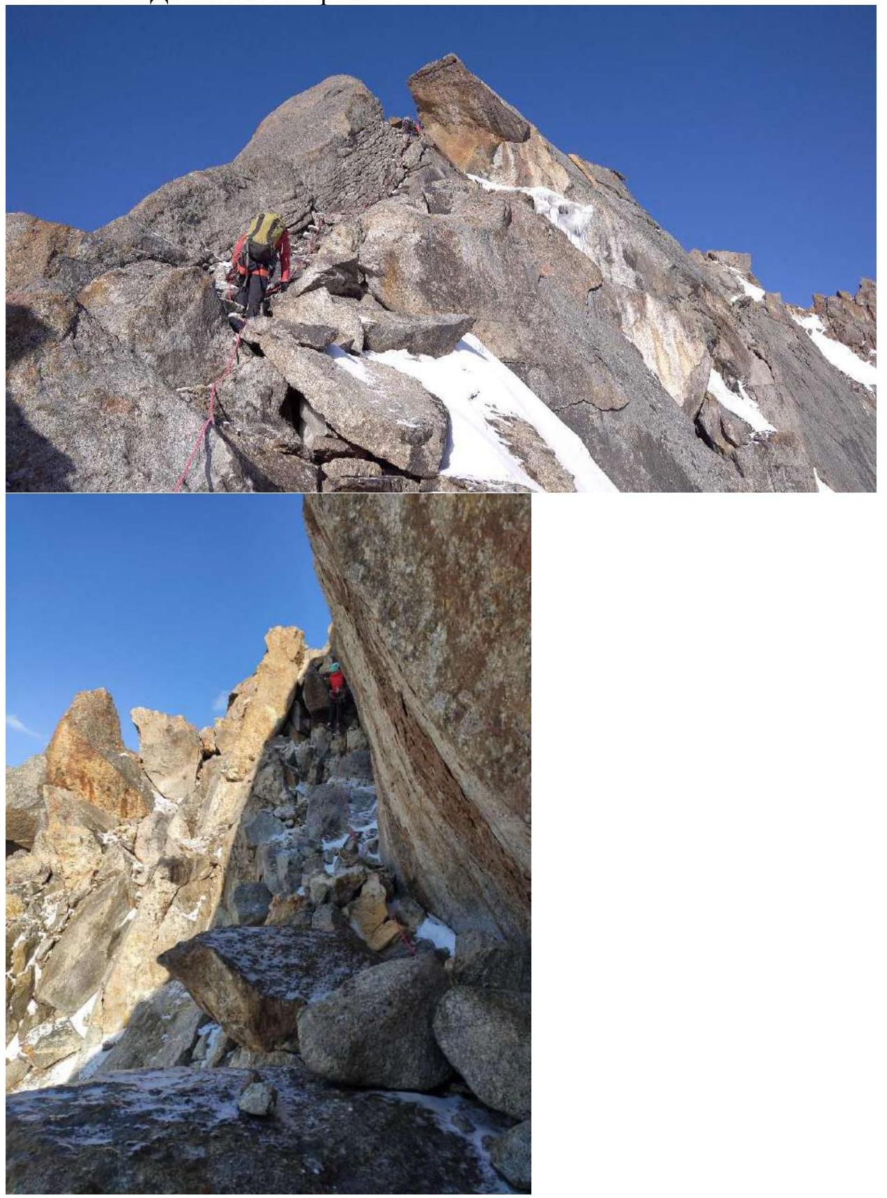
Photo 1. Start of the route
The first section is relatively gentle, following a pronounced chimney (internal angle).
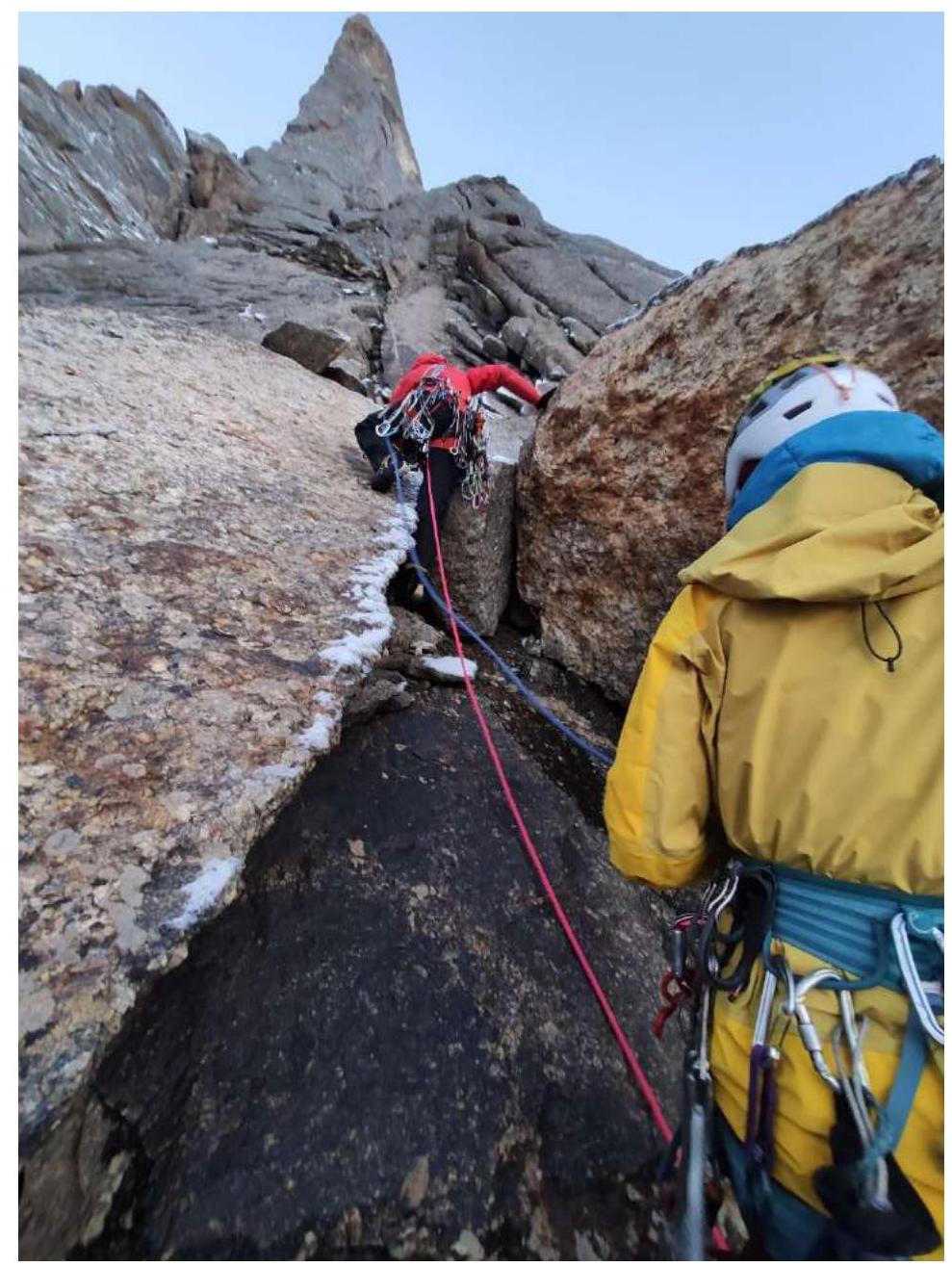
Photo 2. Start at section R0–R1
- Sometimes it is necessary to exit the chimney onto "ram's foreheads," but we return to the chimney.
- Movement along the chimney — 60 m.
- There are complex sections of 5–6 m.

Photo 3. Bypassing the overhanging wall via "ram's foreheads," R1–R2
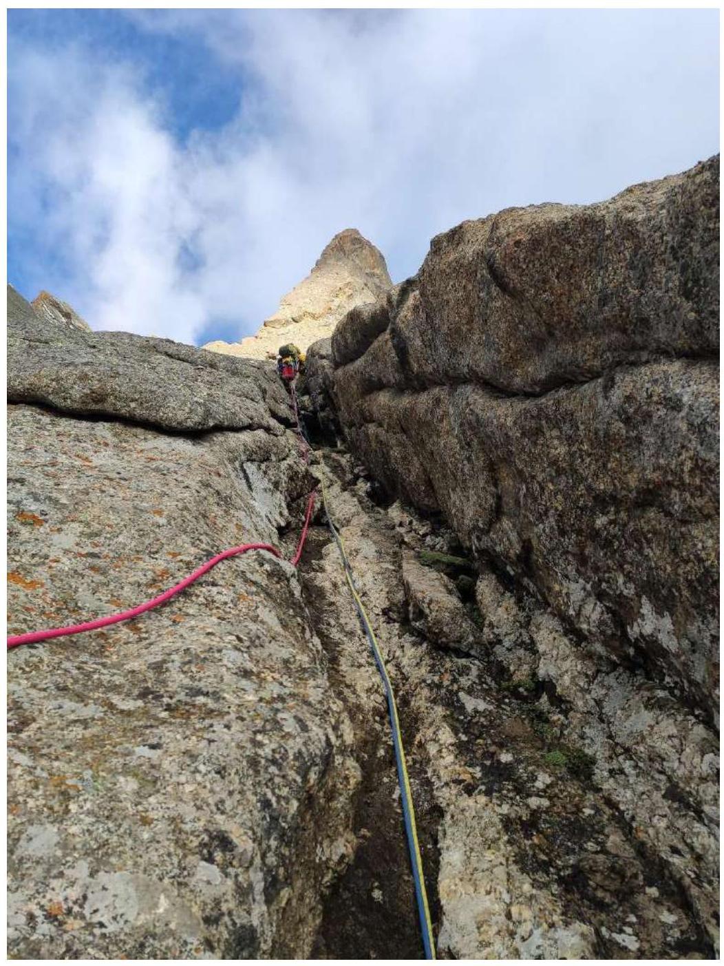
Photo 4. Movement along the chimney, R2–R3. Ascending to gentle rocks, несложное лазание по разрушенному рельефу вверх, choosing the easiest path. The main danger here is dropping rocks with ropes onto the team. There is also snow on the rocks.
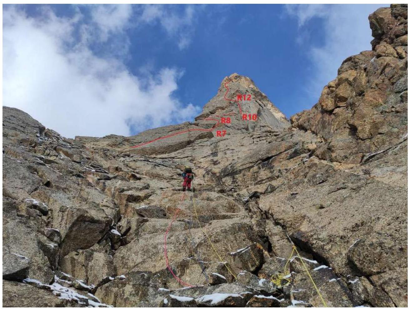
Photo 5. Second climber ascending via simple rocks (R3–R4), from here sections R7–R8 (a small overhang) and the key section R10–R12 are visible. The terrain becomes steeper, and complex climbing begins along an oblique crack.
Photo 6. Lead climber traversing the oblique crack, R5–R6. At 9:00 AM, during the lead climber's passage of R6–R7, snow began to fall (fine grains), stopping after 30 minutes, but all rocks became wet.
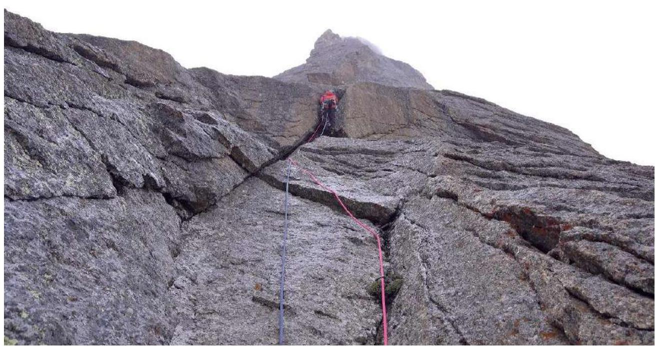
Photo 7. Lead climber using ITO to traverse the oblique crack, R7–R8. The snow had stopped, and the terrain was wet. The weather then improved, and the rocks dried relatively quickly. Further movement was directed towards large cornices; we decided to pass under them from left to right to a good ledge.
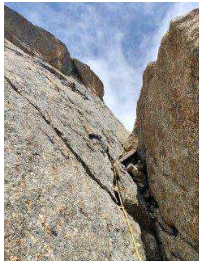
Photo 8. Movement along cornices via a chimney, R9–R10
The team gathered on the ledge and conducted a leader change.
The weather deteriorated again — heavy wet snow began to fall. The terrain was extremely unpleasant, with tight slots for anchors and "live" flakes, ITO A2, and sections of 5–7 m A3. It took about 2.5 hours to pass 60 m of complex sections.
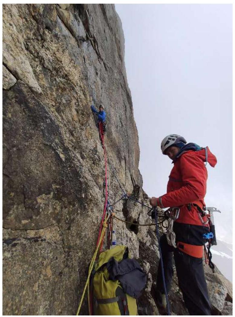
Photo 9–10. Beginning of key sections, cloud approaches, snow starts R10–R11
The weather improved again, the sun came out, and the rocks began to dry.
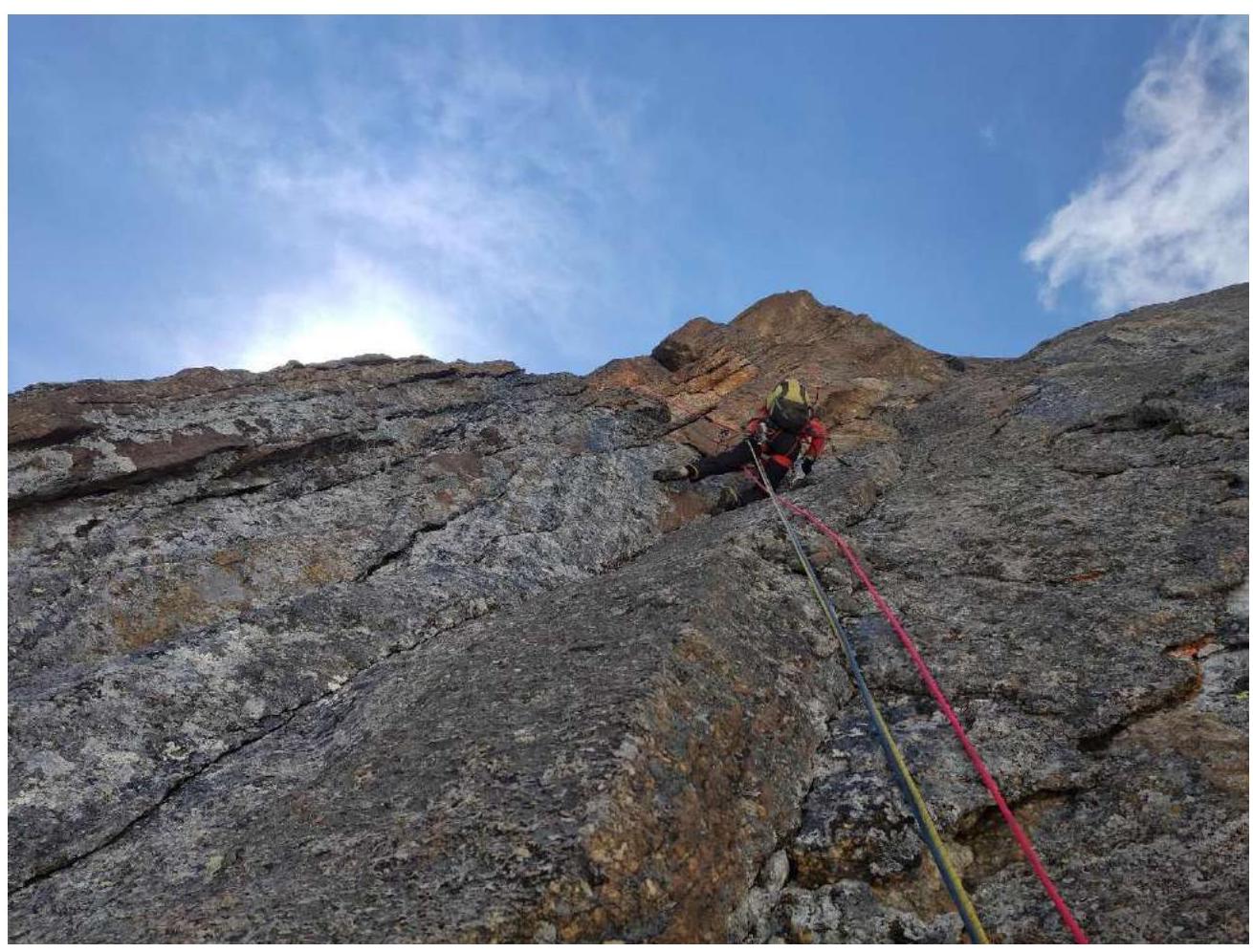
Photo 11. Second climber setting points, R11–R12, then moving left onto slabs with cracks.
The team reached good terrain — monolithic cracks with suitable insurance points using friends. Movement along such terrain was about 90 m.
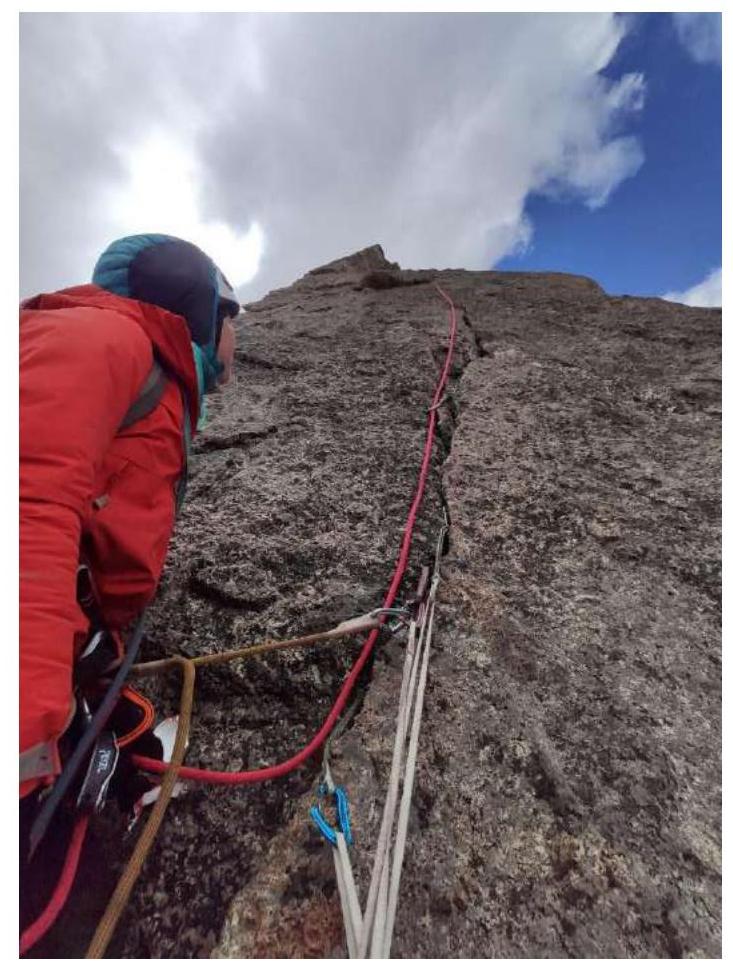
Photo 12. Ascending to a monolithic slab, N. Oleneva on belay at station R13
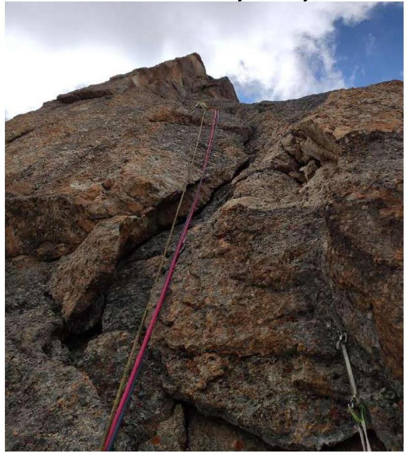
Photo 13. Ascending under the "finger." Taken at station R14. Then, bypassing the "finger" — moving right and upward, and climbing slabs to the overhanging bastion.
The weather began to deteriorate again:
- Cloud settled on the mountain,
- Snow started.
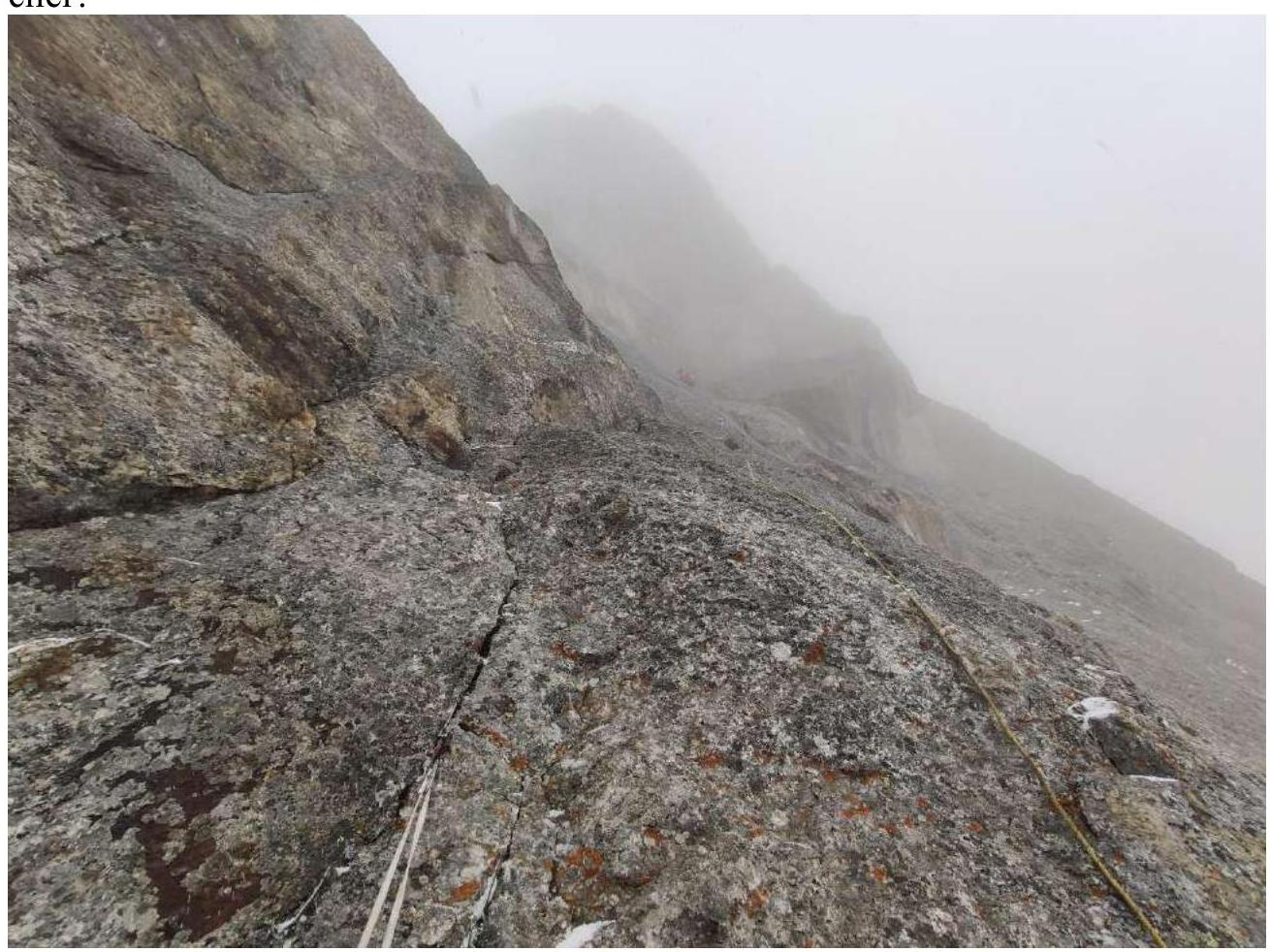
Photo 14. The "finger" on the left, the second climber stands under the upper overhanging bastion and begins movement left from R16. Taken from station R15.
For the third climber, sections R15–R17 were straightened. Further, moving left, traversing to bypass the overhanging bastion. Here, the team slowed down significantly due to the onset of a blizzard.
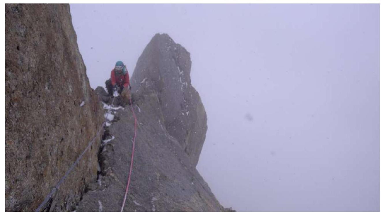
Photo 15. N. Oleneva approaching R17. Visibility is not very high.
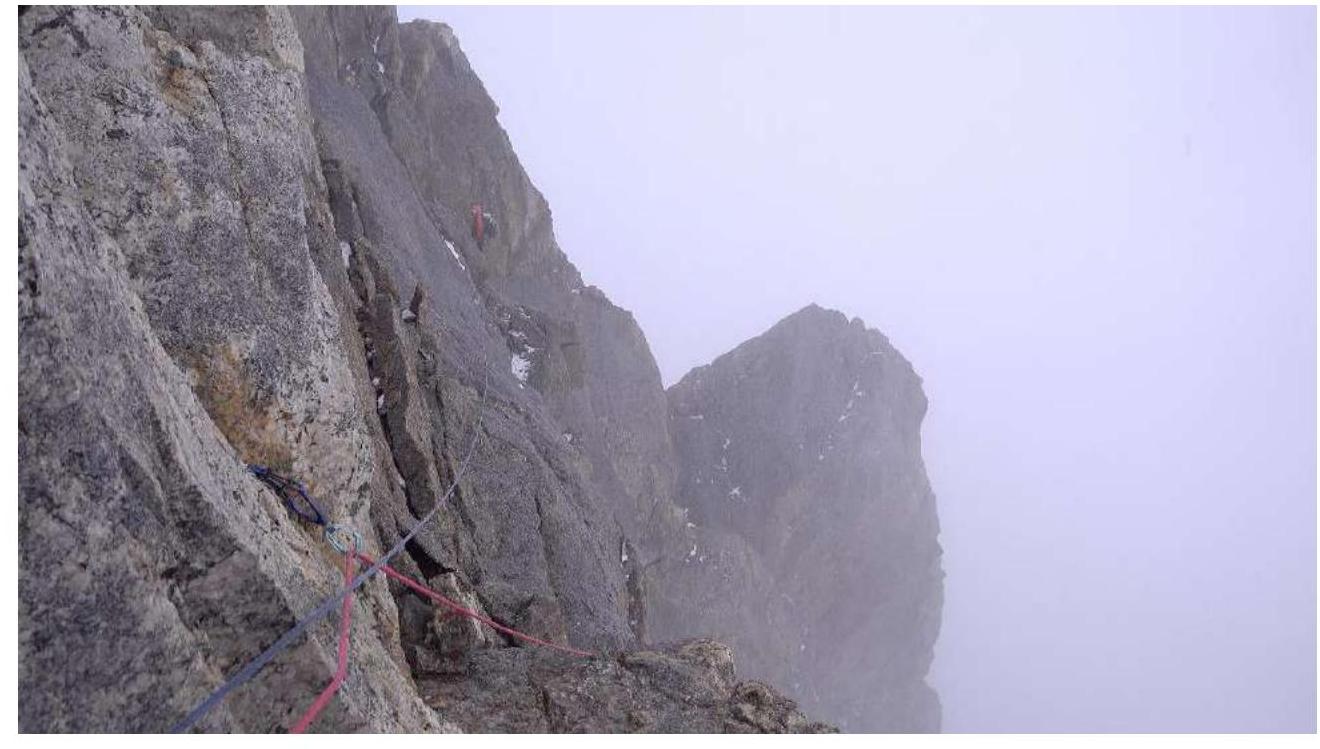
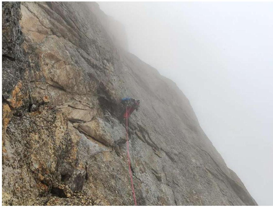
Photo 16. Traverse, taken by the leader from R18. The snow had stopped, and everything had melted. As it was around 19:00, water on the rocks began to freeze, covering everything with a thin layer of ice.
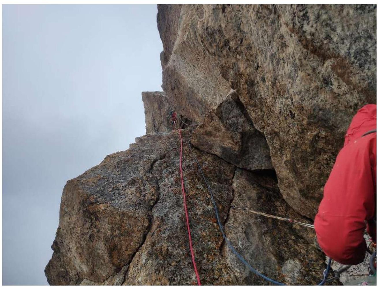
Photo 17. The first climber working on the overhanging wall, moving left and upward via good but overhanging cracks. Taken from R18. Further, exit onto a gentle ledge. We established a camp directly under the ridge, taking about an hour to prepare a flat area for the tent. The weather normalized again.
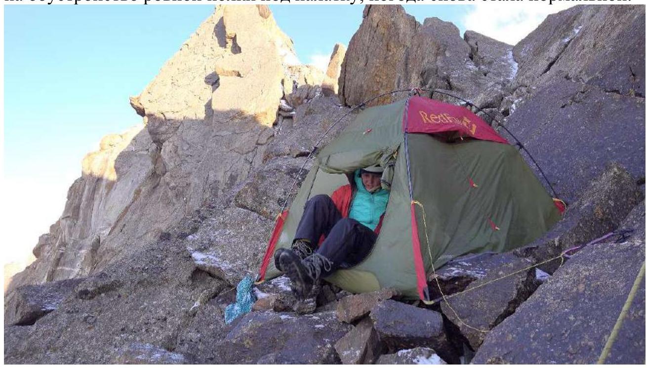
Photo 18. Morning of August 5, team packing before moving along the ridge. At 8:00 AM, we began ascending the ridge, primarily moving simultaneously and organizing variable belays in more complex sections. All gendarmes were bypassed on the left. After approximately 250 m, we made a rappel to the left to bypass a gendarme (about 15 m) and then continued along the ridge.
Photo 19–20. Movement along the ridge
Reached the summit at 12:00 PM on August 5. At the summit, we built a cairn, left a note, and began descending towards the Tro-Block pass.
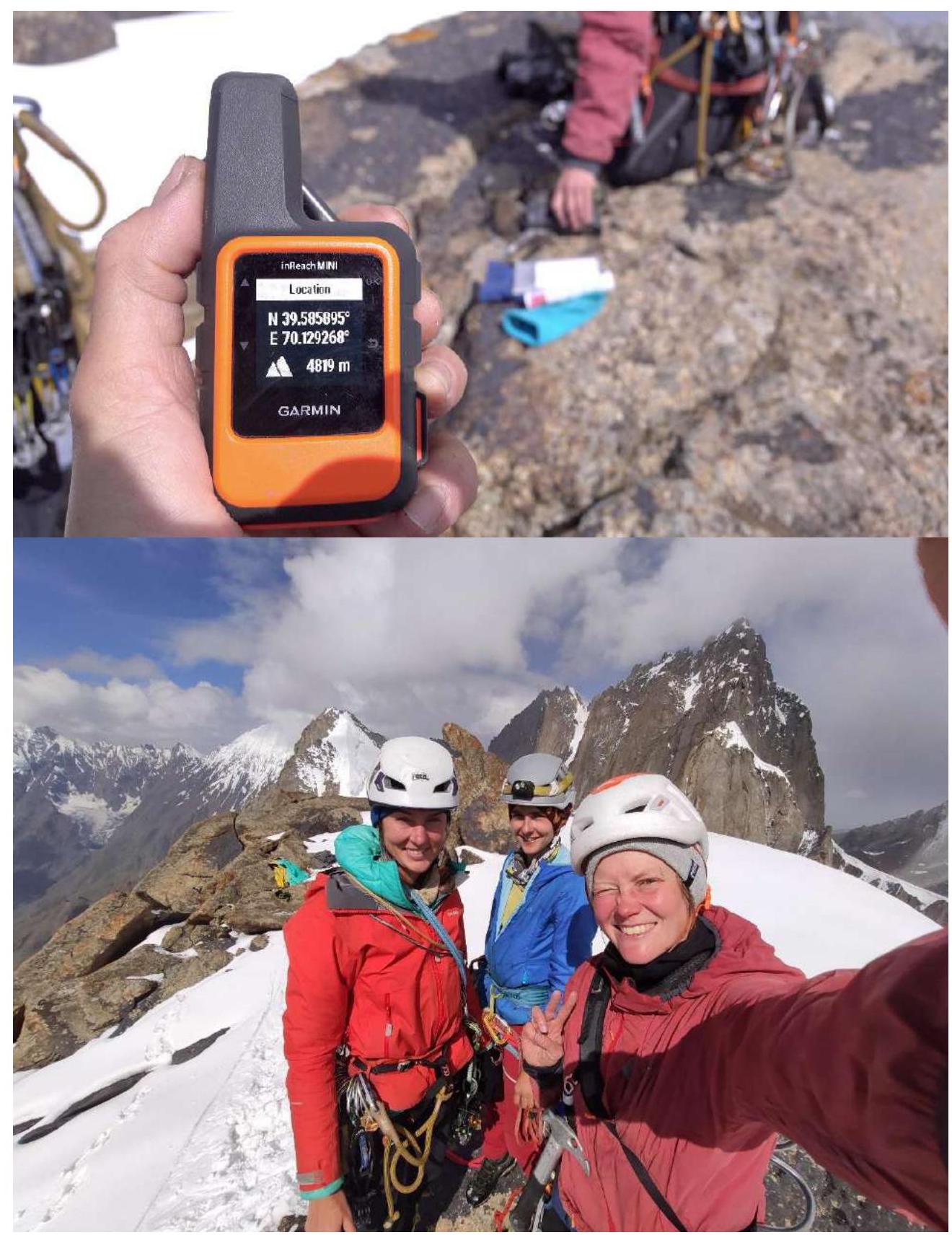
3.2. Photo of the team on the summit, with Peak Blok's massif in the background.
Descent towards Peak Blok to the Tro-Block pass. There were no human traces on the summit, route, or descent to the pass.
Route description by sections
| Section # | Description | Photo # |
|---|---|---|
| R0–R1 | Upward via an internal angle, which widens into a chimney 30 m, 30° III | 1,2 |
| R1–R2 | Leftward via slabs to bypass a cornice, station immediately after the cornice 30 m, 40° IV | 3 |
| R2–R3 | Upward via a chimney, occasionally more complex sections of 4–5 m, 60 m, 55° IV | 4 |
| R3–R4 | Upward via gentle rocks towards a large reddish internal angle, exiting onto a ledge 55 m, III, 5 m, V 40° | 5 |
| R4–R5 | Traverse left along a ledge 20 m, 20° II | |
| R5–R6 | A crack veering right, steepness increases, complex climbing in places. Station in a hazardous chimney 30 m, 75° V | 6 |
| R6–R7 | From the chimney upward via simple rocks towards a cornice. Station 8 m from the cornice 30 m, 55° IV | |
| R7–R8 | Through an overhanging crack (large friends) upward 54 m, 70° VI, 6 m, 95° A1 | 7 |
| R8–R9 | Left and upward via simple rocks 30 m, 45° IV | |
| R9–R10 | Right and upward via a gentle chimney (under cornices). Exit onto a good ledge. Here, if necessary, a tent can be pitched for an overnight stay. 40 m, 30° III | 8 |
| R10–R11 | Upward via a wall, cornices remain on the left. Terrain is hazardous, many points are only for protection. Insurance is only on anchors. 30 m, 80° VI, A2–A3 | 9,10 |
| R11–R12 | Initially upward, then left, exiting left onto a small ledge. 30 m, 85° VI, A2. | 11 |
| R12–R13 | From the station left and then upward via a good crack. Good wedging. Camalots of sizes 3–4 are used, all friends. 30 m, 70° VI | 12 |
| R13–R14 | Upward via good, reliable cracks. 30 m, 85° VI+, A0 | 12 |
| R14–R15 | Upward towards a large internal angle and the "finger" above it, then traversing right. 30 m, 75° VI | 13 |
| R15–R16 | Right and upward via slabs, approaching a steep wall, 20 m, 65° VI | 14 |
| R16–R17 | Left and upward via a slab, then an overhanging crack (friends, anchors), retreating left behind a bend. 30 m, 85° VI, A1 | 14,15 |
| R17–R18 | Traverse left along ledges to bypass a bastion — 30 m, 40° III | 16 |
| R18–R19 | Upward and left via a slab, overhanging cracks, an internal angle, exiting onto a gentle slope. On the ridge, a ledge is equipped for an overnight stay. 15 m, 90° VI A1, 15 m, 45° VI | 17 |
| R19–R21 | To the summit — predominantly simultaneous movement along the ridge, gendarmes are bypassed on the left. Before the second gendarme, a rappel of 15–20 m to the left (a reepschnur is left) and then via simple rocks (3–4 climbing) to the summit gendarme. Total of 400 m movement along the ridge | 18,19,20 |
3.3. The route is objectively safe, with no falling rocks or ice. This line is also the most logical and beautiful path to the summit.
Communication was maintained every two hours (on even hours) with Denis Prokofiev, who was at ABC and was prepared to provide guidance on orientation if needed. The team also had a Garmin tracker for emergency communication.
Descent from the summit:
- 40 m on foot along the pronounced western ridge towards the Tro-Block pass
- Two rappels of 55 m to the left (loops were left)
- 50 m on foot — traversing back to the ridge
- Two diagonal rappels along the ridge towards the pass
- Climbing 10 m to a gendarme
- Another 2 diagonal rappels (20 and 50 m along the ridge), loops and anchor hooks were left
- Descent of 60 m via the southern wall (to the left)
- 50 m on foot to the Tro-Block pass
- 60 m along the pass via a thick metal cable on a snow-ice slope to a bergschrund
- Descent via the glacier along the moraine, linked, to the assault camp, and after collecting gear — immediately to the base camp.
After the descent, the weather deteriorated significantly, and all rocks were covered in snow by night.
Comparing this route to others in neighboring valleys based on personal experience (M. Popova has been to Karavshin three times and Lyaylyak once):
- The resulting route is more complex than 5B Gorbenco (left part of the W wall) on Peak Asan 4230 m and 5B Petrichenko (via the SW ridge) on Peak Blok, 5239 m.
- In terms of terrain and overall complexity, it is comparable to 6A Ovcharenko (via the right edge of the NW wall) on Peak Odessa, 4810 m.
Therefore, our team believes that the route fully corresponds to 5B category of difficulty and is a good "labor-intensive" 5B for this region.
The peak officially has no name, but a local shepherd referred to it in Kyrgyz and translated it for us as "Sharp, pointed."
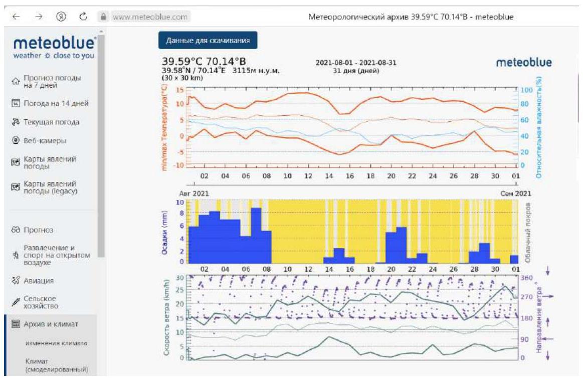
4. Characteristics of Weather Conditions
4.1. Confirmation of data indicated in the Climbing Report with screenshots of weather forecasts from websites