Russian Mountaineering Championship
high-altitude technical class 2021
REPORT
on the ascent to the summit of Svarog, 5005 m, via the center of the North face
6B category of difficulty, first ascent by a combined team from Krasnoyarsk Krai, Novosibirsk, and Moscow
For the period 10.08.2021–14.08.2021
2021
| 1. General Information | ||
|---|---|---|
| 1.1 | Full name, sports rank of the leader | Parfenov A.A. (MS) |
| 1.2 | Full name, sports rank of participants | Mukhametzyanov R.N. (MS) Sukharev A.Yu. (CMS) Timofeev V.M (CMS) Stepanov N.A. (CMS) |
| 1.3 | Full name of coach | Zakharov N.N. (MSMK), Balezin V.V. (MSMK) |
| 1.4 | Organization | Krasnoyarsk Krai Alpine Federation |
| 2. Characteristics of the Ascent Object | ||
| 2.1 | Region | Gissar-Alai |
| 2.2 | Valley | Achat Valley |
| 2.3 | Section number according to the 2013 classification table | 5.4.2 |
| 2.4 | Name and height of the summit | Svarog, 5005 |
| 2.5 | Geographic coordinates of the summit (latitude/longitude), GPS coordinates | – |
| 3. Route Characteristics | ||
| 3.1 | Route name | Via the center of the North face |
| 3.2 | Proposed category of difficulty | 6B |
| 3.3 | Degree of route exploration | First ascent |
| 3.4 | Relief characteristics of the route | Combined |
| 3.5 | Height difference of the route (data from altimeter or GPS) | 1120 m |
| 3.6 | Route length (in meters) | 1422 |
| 3.7 | Technical elements of the route (total length of sections with varying difficulty, indicating relief characteristics (ice-snow, rock)) | II–III cat. diff. – 155 m IV cat. diff. – 410 m V-IV cat. diff. – 717 m |
| 3.8 | Average steepness of the route, (°) | 67 degrees |
| 3.9 | Average steepness of the main part of the route, (°) | 78 degrees |
| 3.10 | Descent from the summit | Via the ascent route |
| 3.11 | Additional route characteristics | Safe from rockfall |
| 4. Characteristics of Team Actions | ||
| 4.1 | Time of movement (team's walking hours, in hours and days) | 41 h, 3.5 days |
| 4.2 | Overnight stays | On a platform |
| 4.3 | Time spent on route preparation | 0 h, 0 days |
| 4.4 | Departure for the route | 6:00 10.08.2021 |
| 4.5 | Arrival at the summit | 16:00 13.08.2021 |
| 4.6 | Return to ABC | 14:00 14.08.2021 |
| 5. Weather Conditions Characteristics | ||
| 5.1 | Temperature, °C | −5 +5°C |
| 5.2 | Wind speed, m/s | Up to 10 m/s |
| 5.3 | Precipitation | – |
| 5.4 | Visibility, m | Clear |
| 6. Person responsible for the report | ||
| 6.1 | Full name, e-mail | Parfenov A.A. patriodemoerte@mail.ru |
II. Ascent Description
1. Characteristics of the Ascent Object.
1.1. General photo of the summit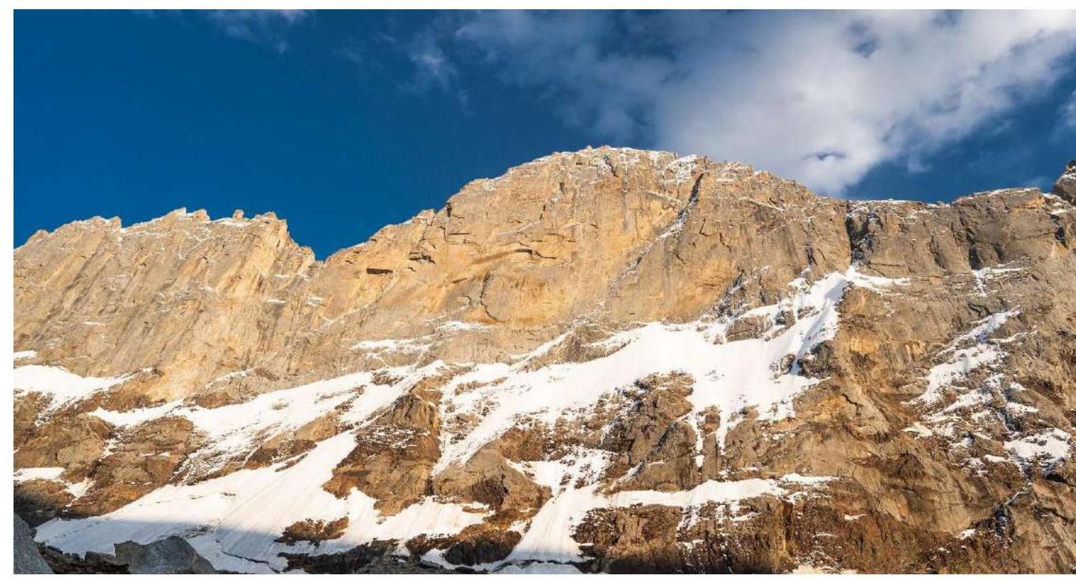
The route taken by the team is also marked on the photo, as is the first line on the mountain passed by K. Markevich in 2014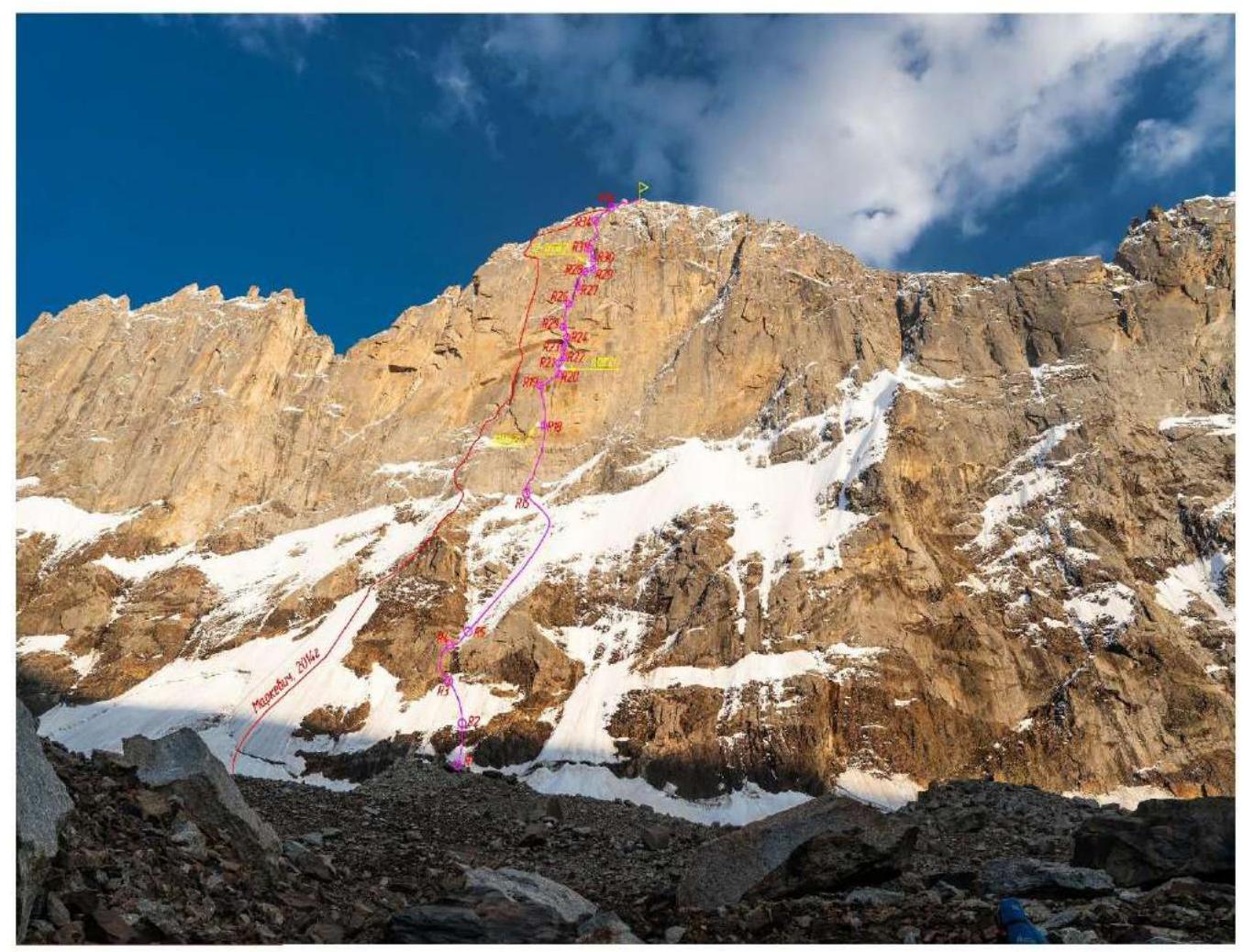
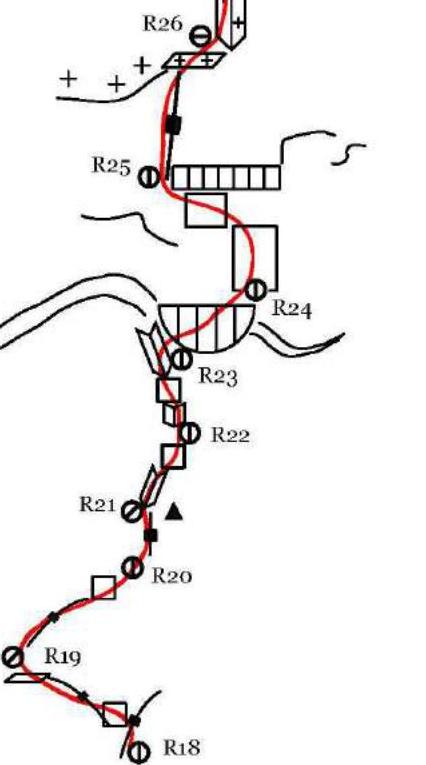
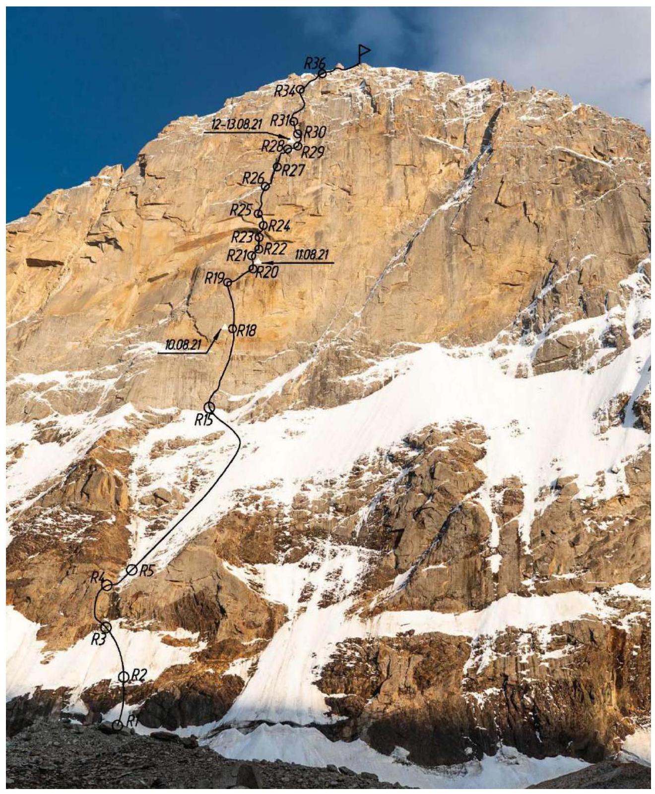
1.2. Photo of the route profile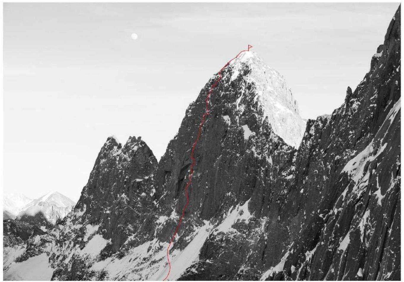
1.3. Drawn profile of the route
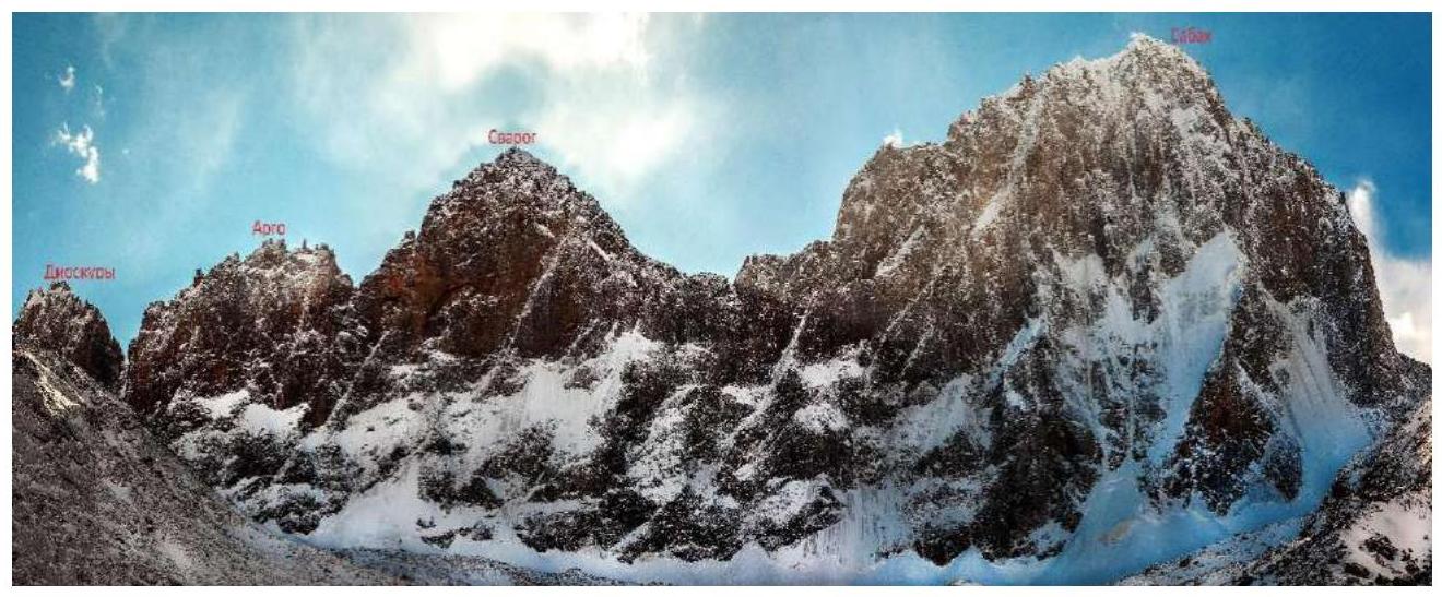
1.4. Photopanorama of the area
1.5. Map of the area
The three main areas of the Turkestan Range: Karavshin, Aksu, and Sabakh are located close to each other and are accessible from one point — Uzgurush village. Karavshin is the easternmost area, and with horses it takes 2.5 days to reach it. The approach from Uzgurush, rather than Vorukh, is advantageous because it passes through passes with beautiful views and combines acclimatization. To the base camp in Aksu, the direct road is about 20 km, taking 6–7 hours. Sabakh (Achat valley) is the westernmost area; the path to it initially follows the main Lyailyak valley (Layla-Mazar), then the Achat valley, with packhorses taking 12–15 hours (one and a half days) to reach the base camp by the glacier, which is twice as far as to Aksu, about 40 km. Since the bridges in the main valley were washed away (as we were told by the handlers), we approached through the Lyailyak valley and then via the "Uryam" 3770 m pass (marked on the map as "Distant") and the "Achat" 4200 m pass (marked on the map as "Pārus"), leading to the upper terrace of the Achat valley. With horses, the journey took 2 days.
The main summits of the area include the four peaks of the Achat Wall:
- Peak Sabakh (5300 m), Peak Svarog (5005 m, уточнённые данные), Peak Argo (4750 m), Dioscuri (4700 m), and Peak Parus with three peaks — Western (4850 m), Eastern (4800 m), and Main (5053 m).
Six successful ascents have been made to the main summit of the area, Peak Sabakh (5300 m): five via the north face (Plotnikov 1985, 6A, Bashkirov 1985, 6A, Moshnikov 1986, 6A, Vasiliev 2013, 6B, Markevich 2017, 6A), and one as part of a traverse of the Achat Wall (Petrov 1990, 6., 6A), and an ascent by a group of tourists under the leadership of S. Romanenkov in the summer of 2019. The North face of Sabakh is the longest in the area — about 25–30 full ropes.
Peak Svarog (5005 m, уточнённые данные). The North face of Svarog is the steepest in the area, with a height difference from the bergschrund to the summit of over 1000 m. In the left part of the face is a huge cornice, about which legends were told in the early 90s. In 2014, the first route through this face was climbed by K. Markevich's team. Also in 2014 and 2015, there were two attempts to ascend this face in winter by a team of Krasnoyarsk climbers led by A. Zhigalov. Recently, a team of Chelyabinsk climbers made a second ascent of Markevich's route, which had been the only route on this face until that summer.
Upon reaching the summit, we уточнённые the height of the peak using a GPS tracker. The height of the summit was 5005 m.
Peak Argo (4750 m). Two routes pass through the North face of Peak Argo: (Petrov, 1989) "via the bastion on the right part of the North face" 6A, and Koshchenko's route in 2013, via the left part of the face "Alkorot" 5B. The face is very steep after the foot, with many crevices filled with ice in the upper part. The central part of the face remains unclimbed.
Dioscuri (4700 m) closes the Achat Wall to the east (Pollux — eastern and Castor — western). The height of the peak is 4700 m according to maps, but it is clearly higher than the neighboring Argo. There is only one route through the cracks and couloirs of the North face — the beginning of Petrov's traverse in 1990, 6A. The main face remains unclimbed.
Peak Parus Eastern (4800 m). Four routes have been laid to Peak Parus V. from the Uryam valley: Shorokhov S. "via the North ridge from the saddle" 4B (first ascent), Korsun "via the North ridge" 1990, 4A (likely a repeat of Shorokhov's route), Mityukhin "via the bastion on the NE face" 1989, 5B, Zagirnyak "via the right part of the NE face" 1990, 6A, and a route by an Italian team in the 90s.
Peak Parus Main (5053 m). There is one route to Peak Parus Main: Moskovets E. "via the South edge" 4A. The NW face remains unclimbed.
Peak Parus Western (4850 m). Four routes have been laid to Peak Parus W.: Korolev A. "via the spade on the North face" 5B, Egorova "via the SW edge" 1989, 5B, Koshchenko "via the SSW counterfort" 2008, 5A, and a route by a Krasnoyarsk team "via the spade on the North face" 2014, 5B (possibly a repeat or variation of Korolev's route). The NE face — one of the most monolithic in the area with a height difference of about 900 m and very poor relief — remains unclimbed.
Many routes have been laid to Peaks Achat, Evrika, and Prometheus, ranging from 2B to 5A category of difficulty.
The Achat valley holds many opportunities for first ascents not only of routes with 5A–5B category of difficulty but also more complex 6A and possibly even 6B category of difficulty.
Map-scheme of the area:
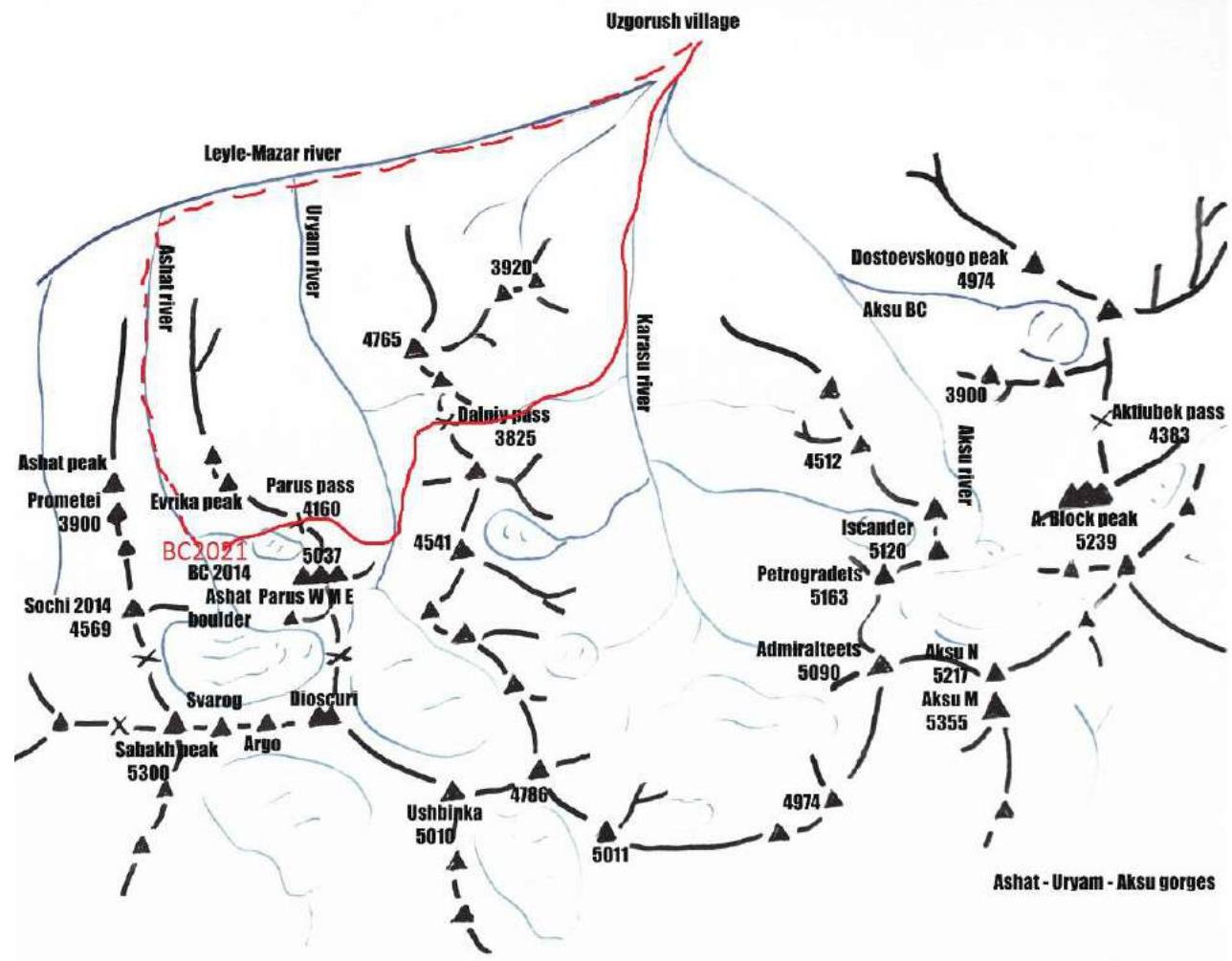
The solid line is the track of our team (about 30 km). The dotted line is an alternative approach through the main valley, used by teams led by A. Zhigalov and K. Markevich in winter 2014–2015, 2017, which in my opinion is more logical and easier (about 40 km).
2. Route Characteristics
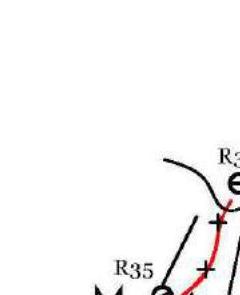
2.1. Technical photograph of the route
2.2. Route diagram in UIAA symbols:
| Friends | Anchors | Nuts | Skyhooks | Buried | Bolts+ Pitons | Length in m | UIAA | Steepness |
|---|---|---|---|---|---|---|---|---|
| 8/6 | 4/4 | 2 | 2 | 45 | VI/A2-A3 | 80°/90° | ||
| 8/6 | 5/4 | 2 | 45 | VI/A2 | 80° | |||
| 5 | 4 | 30 | V | 70° | ||||
| 20 | 300 | IV | 50°/55° | |||||
| 1 | 30 | II-III | 30°/50° | |||||
| 4 | 3 | 40 | V | 75° | ||||
| 4 | 60 | IV | 50° | |||||
| 2 | 2 | 20 | M5 | 75° |


| Friends | Anchors | Nuts | Skyhooks | Buried | Bolts+ Pitons | Length in m | UIAA | Steepness |
|---|---|---|---|---|---|---|---|---|
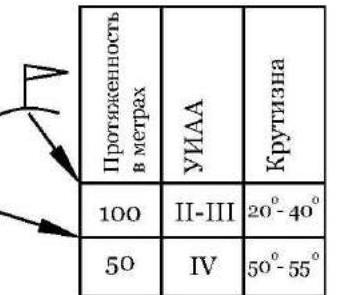
| 3 | 100 | II-III | 20°–40° | |||||
| 5/5 | 4/4 | 6 | 50 | IV | 50°–55° | |||
| 2 | 2 | 1 | 25 | А3 | 80° | |||
| 4/1 | 3/1 | 4 | 35 | IV-V | 70° | |||
| 3/3 | 4/3 | 3 | 4 | 30 | V, VI/A2 | 80° | ||
| 12/11 | 6/6 | 6 | 35 | Wi6, A2 | 80° | |||
| 30 | A2, A3 | 95° | ||||||
| 2/1 | 3/2 | 1 | 3 | 2 | 40 | Wi5, A2, V | 80° | |
| 2 | 4 | 10 | II,A2 | 20°–85° | ||||
| 3 | 45 | Wi6 | 75° | |||||
| 10 | II | |||||||
| 8/8 | 6/6 | 7 | 2 | 40 | A2 | 85° | ||
| 27 | А2е, А2 | 100° | ||||||
| 2/2 | 1/1 | 2 | 10 | 2+2 | 20 | А2е | 100° | |
| 15 | 2+2 | 20 | A2 | 95° | ||||
| 3/3 | 4/4 | 10 | 20 | А2е | 70° | |||
| 10 | 1+1 | 40 | VI/A2-А3 | 80° | ||||
| 3/3 | 3/3 | 12 | 8 | 40 | VI/A2-A3 | 80° | ||
| 4/4 | 8/8 | 15 | 45 | VI/A2-A3 | 80° | |||
| 3/3 | 5/5 | 10 | 10 | 1 |