Passport
Ascent to the summit 4786 m
- Technical class
- Pamir-Alay, Kara-Su gorge
- Summit 4786 m via the northern counterfort of the Eastern ridge.
- Assumed 5B category of difficulty, 3rd ascent.
- Height difference 1000 m.
- Total route length 1680 m. The route is combined.
- Wall section length 600 m.
- Length of sections with 5th category of difficulty — 360 m.
- Average steepness of the wall section 75–80°.
- Average steepness of key sections 85°.
- 134 pitons driven, 7 nuts placed.
- Moving hours 27 h.
- 2 bivouacs on the route.
- Group members: Romanenko A.S. — leader, Romanenko V.I. — participant, Litskevich E.I. — participant, Vasiliev S.I. — participant All are instructors at "Alay" alpine camp.
- Coach: Kavunenko Vladimir Dmitrievich.
- Approach to the route on July 25, 1983.
Summit reached on July 27. Return on July 28. Table of main route characteristics.
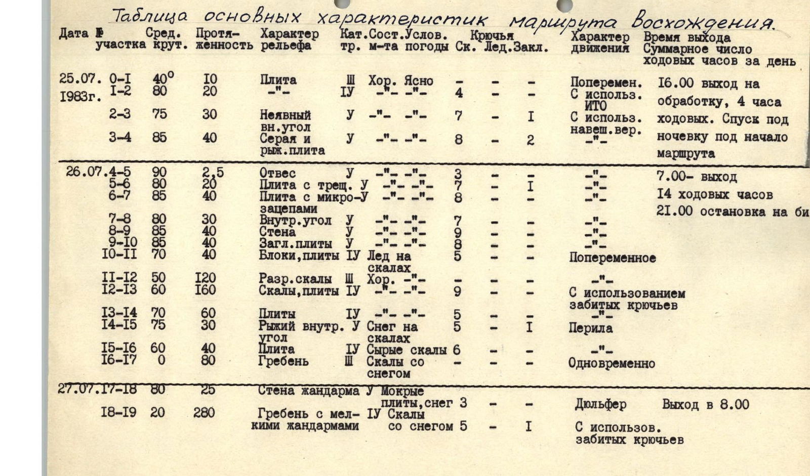
Table of main route characteristics.
Date 25.07.1983
- R0–R1: Average steepness 40°, length 10 m. Terrain: Slab. Technical difficulty: 3. Condition: Good. Weather: Clear. Pitons: –. Ice: –. Nuts: –. Movement: Alternating. Total moving hours for the day: 16:00 approach to processing, 4 h.
- R1–R2: Average steepness 80°, length 20 m. Terrain: ". Technical difficulty: 4. Condition: –. Weather: –. Pitons: 4. Ice: –. Nuts: –. Movement: With use of ITD. Total moving hours for the day: moving hours. Descent to bivouac under the start of the route.
- R2–R3: Average steepness 75°, length 30 m. Terrain: Unclear internal angle. Technical difficulty: 5. Condition: –. Weather: –. Pitons: 7. Ice: –. Nuts: 1. Movement: With use of hanging belay.
- R3–R4: Average steepness 85°, length 40 m. Terrain: Grey and red slab. Technical difficulty: 5. Condition: –. Weather: –. Pitons: 8. Ice: –. Nuts: 2. Movement: ".
Date 26.07.
- R4–R5: Average steepness 90°, length 2.5 m. Terrain: Overhang. Technical difficulty: 5. Condition: ". Weather: ". Pitons: 3. Ice: ". Nuts: –. Movement: –. Total moving hours for the day: 7:00 departure.
- R5–R6: Average steepness 80°, length 20 m. Terrain: Slab with cracks. Technical difficulty: 5. Condition: ". Weather: ". Pitons: 7. Ice: –. Nuts: 1. Movement: ".
- R6–R7: Average steepness 85°, length 40 m. Terrain: Slab with micro-holds. Technical difficulty: 5. Condition: ". Weather: ". Pitons: 8. Ice: –. Nuts: –. Movement: ". Total moving hours for the day: 14 moving hours.
- R7–R8: Average steepness 80°, length 30 m. Terrain: Internal angle. Technical difficulty: 5. Condition: ". Weather: –. Pitons: 7. Ice: –. Nuts: –. Movement: ". Total moving hours for the day: 21:00 stop for bivouac.
- R8–R9: Average steepness 85°, length 40 m. Terrain: Wall. Technical difficulty: 5. Condition: ". Weather: –. Pitons: 9. Ice: –. Nuts: –. Movement: ".
- R9–R10: Average steepness 85°, length 40 m. Terrain: Smoothed slabs. Technical difficulty: 5. Condition: ". Weather: –. Pitons: 8. Ice: –. Nuts: –. Movement: ".
- R10–R11: Average steepness 70°, length 40 m. Terrain: Blocks, slabs. Technical difficulty: 4. Condition: Ice on rocks. Weather: –. Pitons: 5. Ice: –. Nuts: –. Movement: Alternating.
- R11–R12: Average steepness 50°, length 120 m. Terrain: Broken rocks. Technical difficulty: 3. Condition: Good. Weather: ". Pitons: 10. Ice: –. Nuts: –. Movement: ".
- R12–R13: Average steepness 60°, length 160 m. Terrain: Rocks, slabs. Technical difficulty: 4. Condition: –. Weather: –. Pitons: 9. Ice: –. Nuts: –. Movement: Using driven pitons.
- R13–R14: Average steepness 70°, length 60 m. Terrain: Slabs. Technical difficulty: 4. Condition: –. Weather: –. Pitons: 5. Ice: –. Nuts: –. Movement: –.
- R14–R15: Average steepness 75°, length 30 m. Terrain: Red internal angle. Technical difficulty: 5. Condition: Snow on rocks. Weather: –. Pitons: 5. Ice: –. Nuts: 1. Movement: Rappel.
- R15–R16: Average steepness 60°, length 40 m. Terrain: Slab. Technical difficulty: 4. Condition: Wet rocks. Weather: –. Pitons: 6. Ice: –. Nuts: –. Movement: ".
- R16–R17: Average steepness 0°, length 80 m. Terrain: Ridge. Technical difficulty: 3. Condition: Rocks with snow. Weather: –. Pitons: –. Ice: –. Nuts: –. Movement: Simultaneous.
Date 27.07.
- R17–R18: Average steepness 80°, length 25 m. Terrain: Wall of a gendarme. Technical difficulty: 5. Condition: Wet slabs, snow. Weather: –. Pitons: 3. Ice: –. Nuts: –. Movement: Rappelling. Total moving hours for the day: Departure at 8:00.
- R18–R19: Average steepness 20°, length 280 m. Terrain: Ridge with small gendarmes. Technical difficulty: 4. Condition: Rocks with snow. Weather: –. Pitons: 5. Ice: –. Nuts: 1. Movement: Using driven pitons.
- R19–R20: Average steepness 40°, length 120 m. Terrain: Scree inclined ledges, feathers. Technical difficulty: 3–4. Condition: Rocks with snow. Weather: Clear. Pitons: 8. Ice: –. Nuts: –. Movement: Using driven pitons. Total moving hours for the day: Summit reached at 17:00.
- R20–R21: Average steepness 85°, length 40 m. Terrain: Light-colored belt, wall. Technical difficulty: 5. Condition: Dry. Weather: –. Pitons: 8. Ice: –. Nuts: 1. Movement: Rappel.
- R21–R22: Average steepness 65°, length 20 m. Terrain: Internal angle. Technical difficulty: 4. Condition: –. Weather: –. Pitons: 5. Ice: –. Nuts: –. Movement: ".
- R22–R23: Average steepness 50°, length 200 m. Terrain: Scree ledges, slabs, snow. Technical difficulty: 4. Condition: Wet rocks. Weather: –. Pitons: 8. Ice: –. Nuts: –. Movement: Using driven pitons.
- R23–R24: Average steepness 80°, length 20 m. Terrain: Wet ledge, internal angle. Technical difficulty: 5. Condition: –. Weather: –. Pitons: 6. Ice: –. Nuts: –. Movement: Rappel.
- R24–R25: Average steepness 40°, length 80 m. Terrain: Broken rocks, scree. Technical difficulty: 3. Condition: Good. Weather: –. Pitons: –. Ice: –. Nuts: –. Movement: Simultaneous.
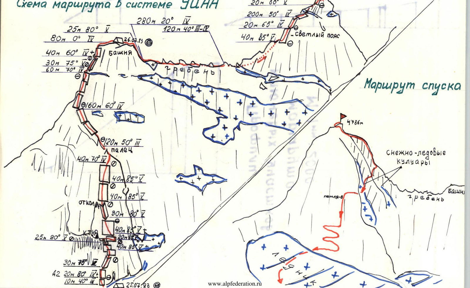
Description of the route to v. 4786 m via the Northern counterfort of the Eastern ridge, 5B approximately (3rd ascent).
Passing by the camps, through the sources of the Kara-Su river, we head towards the Northern counterfort of the Eastern ridge of summit 4786 m. We ascend via the large moraine and move along the walls of the Eastern ridge to the 6th counterfort — 1.5 h. Immediately behind it, there is a high wet chimney-couloir. The counterfort has the appearance of a vertical pillar with a red flake in the middle and a small "finger" at the top.
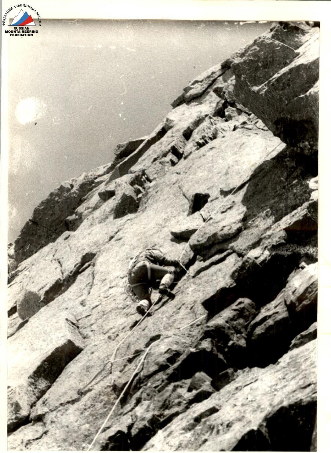
We start the route via a grey slab, to the left of the counterfort. The slab is triangular in shape with its apex pointing downwards, bounded by two small snowfields. R0–R1: Along the slab 40°, 10 m to a ledge, where a cairn is built without a note. 3rd category of difficulty. R1–R2: Above the ledge, a grey slab angles upwards. Along the left side of the triangle 20 m to its apex. (Slab 80°, 4 pitons, 4th category of difficulty). R2–R3: From the apex of the triangle, upwards to the right along an indistinct internal angle 30 m to a small inclined ledge. Belay is inconvenient. 75°. 7 pitons, 5th category of difficulty. R3–R4: 40 m upwards to the left under an overhang via a grey, then red slab to an inclined ledge, steepness 85°, 8 pitons driven, 2 nuts placed, a control cairn on the ledge. Processing is completed, descent to bivouac under the route. R4–R5: In front of the inclined ledge, an overhang 2.5 m, 90°, 3 pitons. R5–R6: From the ledge, traverse 20 m to the right and downwards along a slab 80° with a crack, bypassing the overhang to an inclined ledge, belay is inconvenient, 5th category of difficulty, 7 pitons, 1 nut. R6–R7: Upwards to the left 40 m along a slab with small cracks 85°, exit to a ledge convenient for belay, 5th category of difficulty, 8 pitons. R7–R8: Upwards along an internal angle 30 m, 80° to a flake. Belay is inconvenient, 7 pitons. R8–R9: Straight up along the wall 40 m, 85°, 9 pitons. R9–R10: 40 m along smoothed slabs 85° with an exit to the shoulder of the counterfort (near the "finger"), 8 pitons, a platform. R10–R11: Upwards 40 m along the ridge (live rocks), 70°, 5 pitons, with an exit to a scree shoulder before a tower. R11–R12: Along scree and slabs 120 m upwards under the tower 50°. R12–R13: Along the slabs of the tower, veering left, 160 m, 4th category of difficulty, 60°, 9 pitons. R13–R14: Traverse 60 m left under an overhang, 5 pitons. R14–R15: Upwards along a red internal angle 75°, 5th category of difficulty, 5 pitons, 1 nut. R15–R16: 40 m upwards along a slab, bypassing the overhang on the left, 60°, 6 pitons. R16–R17: Exit to the top of the tower, bivouac. R17–R18: Rappelling 25 m down to a scree ridge, 3 pitons. R18–R19: Movement along the ridge on the right side through small gendarmes 4th category of difficulty, 280 m. Average steepness of the ridge 15°. Snow on ledges. Before the ascent of the ridge, which has the appearance of forked "feathers", there is a place for bivouac and ice. R19–R20: Traverse of a gendarme on the left 120 m along ledges, 8 pitons, 4th category of difficulty. R20–R21: 40 m upwards along a light-colored wall of a rock belt 80°, 8 pitons, 5th category of difficulty, exit to a ledge. R21–R22: 20 m upwards along an internal angle 65°, 4th category of difficulty. R22–R23: 200 m upwards along slabs, scree ledges, and snow, veering left, 4th category of difficulty, 8 pitons. R23–R24: From a small ledge upwards along an internal angle 80°, 20 m, 6 pitons, 5th category of difficulty. R24–R25: Along scree ledges and slabs 80 m ascent to the summit. We reached the summit at 17:00. The summit consists of blocks standing one on top of another.
Descent. Along the ascent route down to ledges about 200 m. Rappelling 30 m. Then to the right and down along the couloir between the ridges (sporting 30 m) and exit along a ledge to the second ridge with a notch. Further along scree ledges to the right 50 m to a loop. Rappelling 40 m to a scree ledge and descent along a snowfield to the glacier between peak 4960 m and 4786 m. Further along the glacier and scree to the camps. Descent takes 4–5 h.
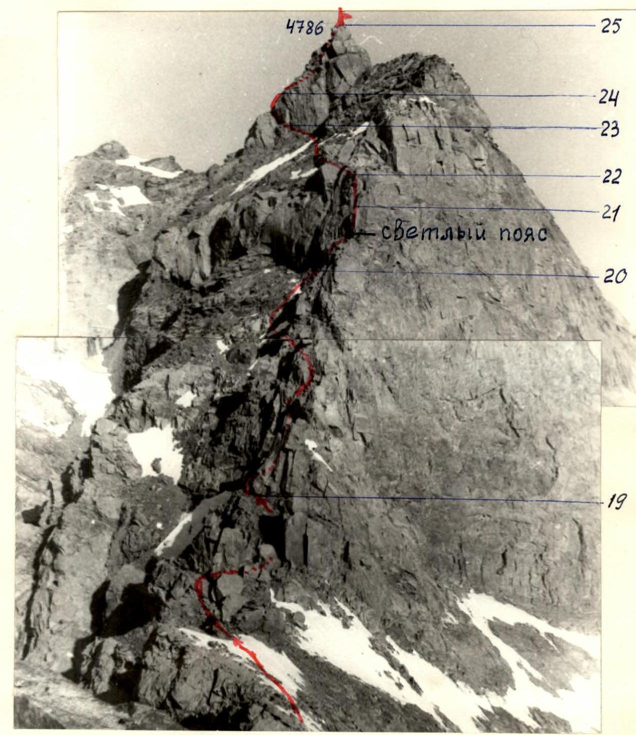
Section R19–R25. The photo was taken from a bivouac on the top of the tower.
Passage of the light-colored wall.
Section R20–R21.
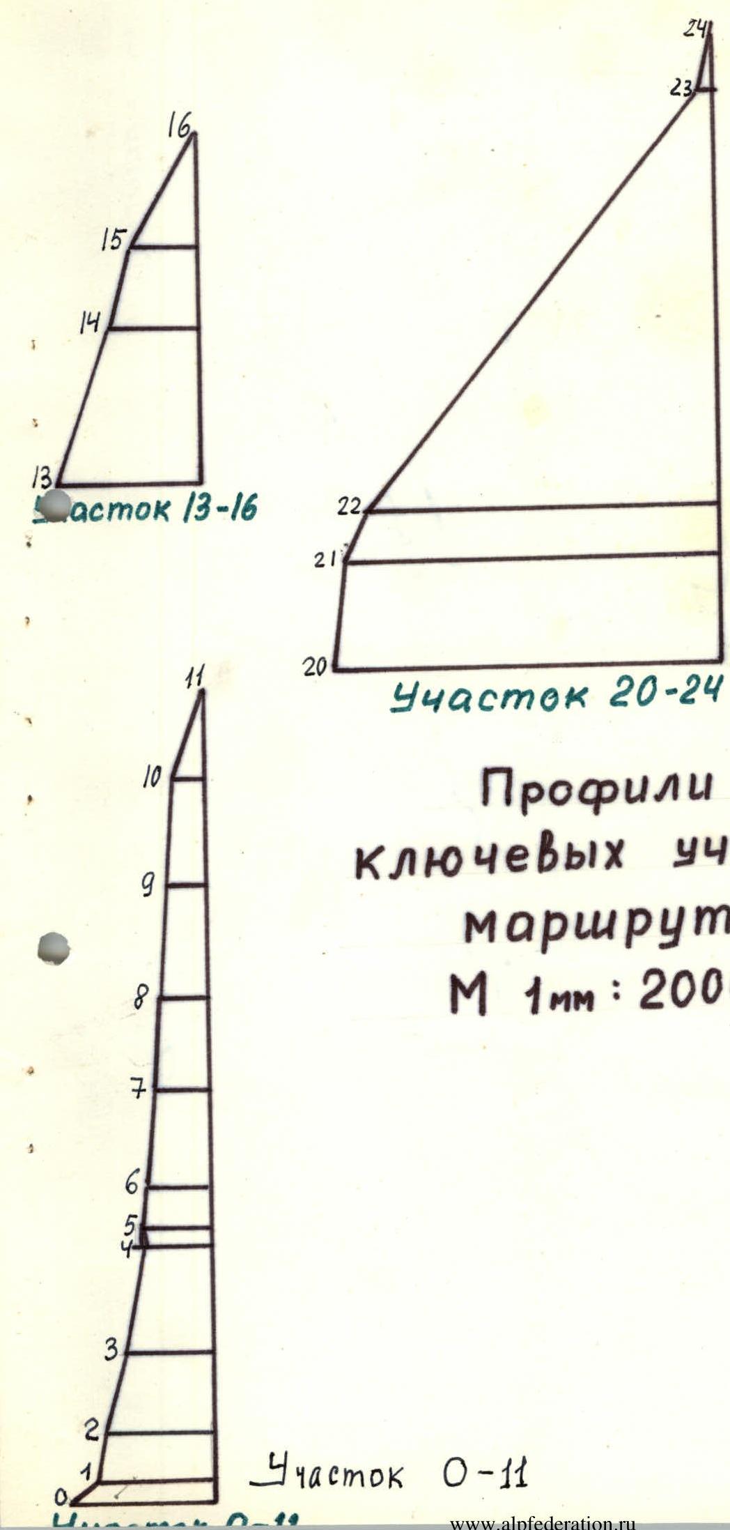
Profiles of key route sections
Scale 1:2000
Route diagram in the UTSAA system