Passport
- Class of traverses
- Turkestan Range, Achat gorge
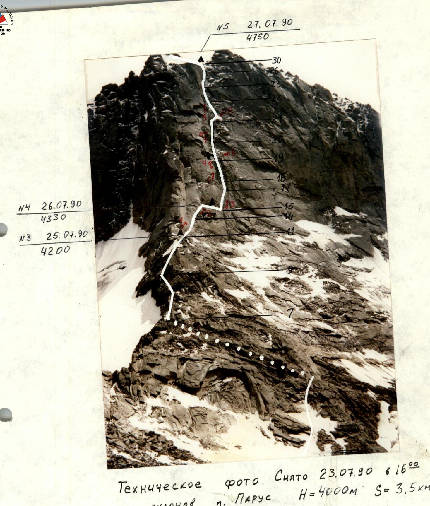
- Achatskaya wall (peaks 4700–4750–4810–Sabakh)
- Assumed 6B, first ascent
- Route characteristics: A. Initial ascent route to peak 4700: Elevation gain — 950 m Length — 1445 m Length of sections with V–VI difficulty — 830 m Average steepness of the main part of the route — 74° Steepness of sections with V–VI difficulty — 82° B. Traverse: Length — 6055 m Length of sections with V–VI difficulty — 2840 m Steepness of sections with V–VI difficulty — 75°
- Number of climbing hours — 143 hours and days — 12
- Overnights: 1 — sitting, 1 — semi-reclining, 8 — lying down
- Leader: Petrov Nikolai Evgenievich — MS Participants: Bashkirov Vladimir Leonidovich — MS Belyaev Igor Borisovich — CMS Egorov Dmitry Anatolievich — CMS Koroteev Vladimir Konstantinovich — IMS Mikhailov Sergey Vladimirovich — MS Stetsenko Vladimir Dmitrievich — CMS Yanochkin Vladimir Ivanovich — MS
- Coach: Bashkirov Vladimir Leonidovich — MS
- Entry to the route: July 23, 1990 Summit Sabakh: August 3, 1990 Return: August 4, 1990
- Organization: Committee for Physical Culture and Sports under the Moscow City Executive Committee
Route Diagram
M1:2000
12 hours
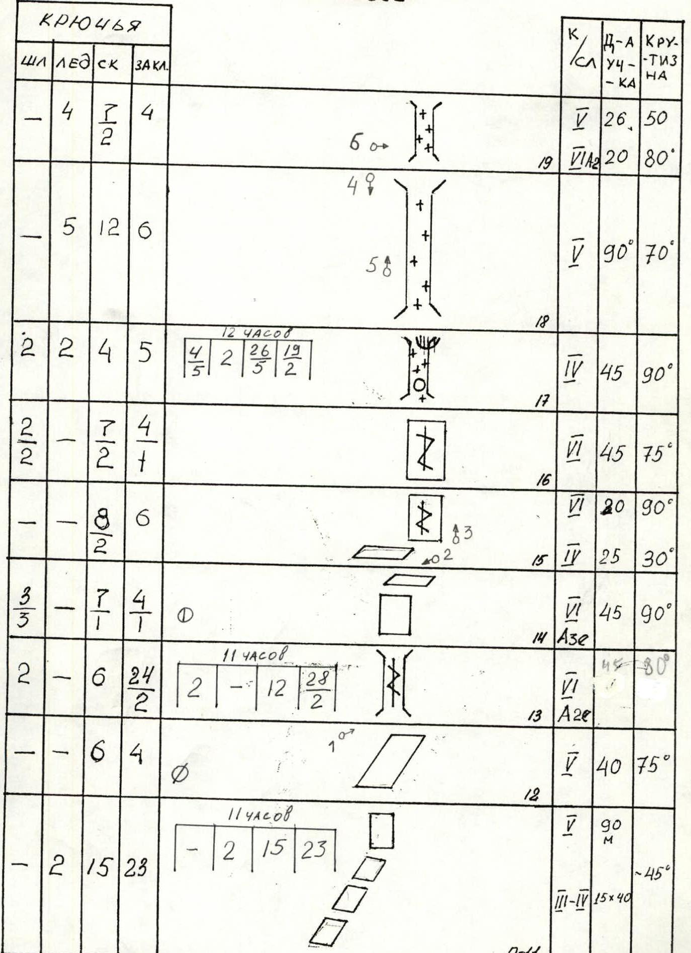
| Belay | ICE | ROCK | CAM | Diff. level | Section length | Steepness |
|---|---|---|---|---|---|---|
| – | 4 | – | 4 | 5 | 26 | 50° |
| – | 5 | 12 | 6 | 5 | 90 | 70° |
| 2 | 2 | 4 | 5 | 4 | 45 | 90° |
| – | 7 | 2 | 4 | 5 | 45 | 75° |
| – | 8 | 6 | – | 6 | 20 | 90° |
| – | – | – | – | 4 | 25 | 30° |
11 hours
| Belay | ICE | ROCK | CAM | Diff. level | Section length | Steepness |
|---|---|---|---|---|---|---|
| 3 | 7 | 3 | 4 | 5 | 45 | 90° |
| 2 | 6 | 24 | 2 | 6 | 45 | 80° |
| – | 6 | 4 | – | 5 | 40 | 75° |
11 hours
| Belay | ICE | ROCK | CAM | Diff. level | Section length | Steepness |
|---|---|---|---|---|---|---|
| 2 | 15 | 28 | – | 5 | 90 m | –45° |
| – | – | – | – | 3–4 | 15x40 |
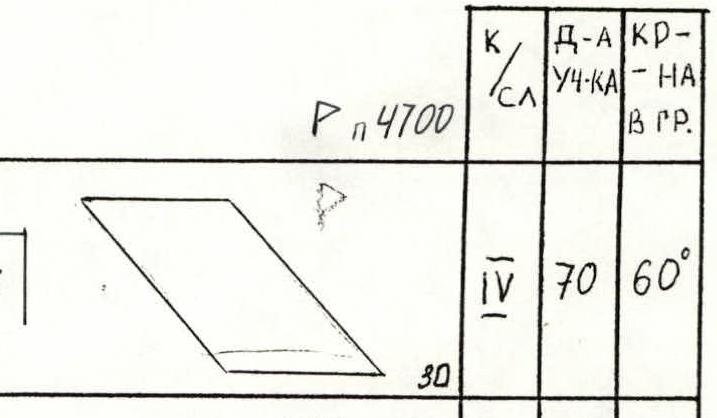
P 4700
13 hours
| Belay | ICE | ROCK | CAM | Diff. level | Section length | Steepness |
|---|---|---|---|---|---|---|
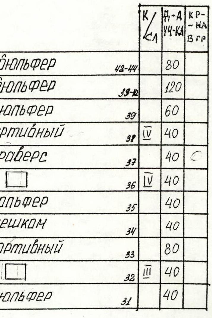
| – | 7 | 3 | – | 4 | 70 | 60° |
| – | – | 10 | 31 | 13 | ||
| – | 1 | 4 | 3 | 4 | 40 | 45° |
| – | 4 | 1 | – | 5 | 20 | 50° |
| – | 4 | 1 | – | 5 | 20 | 60° |
| – | 5 | 2 | – | 6 | 15 | 80° |
| – | 4 | 2 | – | 5 | 15 | 60° |
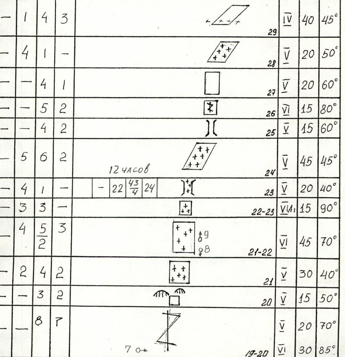
12 hours
| Belay | ICE | ROCK | CAM | Diff. level | Section length | Steepness |
|---|---|---|---|---|---|---|
| 5 | 6 | 2 | – | 5 | 45 | 45° |
| – | 22 | 43 | 24 | |||
| – | 3 | 3 | – | 5 | 20 | |
| 4 | 5 | 3 | 2 | 6 | 15 | 90° |
| 2 | 4 | 2 | – | 5 | 45 | 70° |
| – | 3 | 2 | – | 5 | 30 | 40° |
| – | 8 | 7 | – | 5 | 15 | 50° |
| – | – | – | – | 5 | 20 | 70° |
| – | – | – | – | 6 | 30 | 85° |
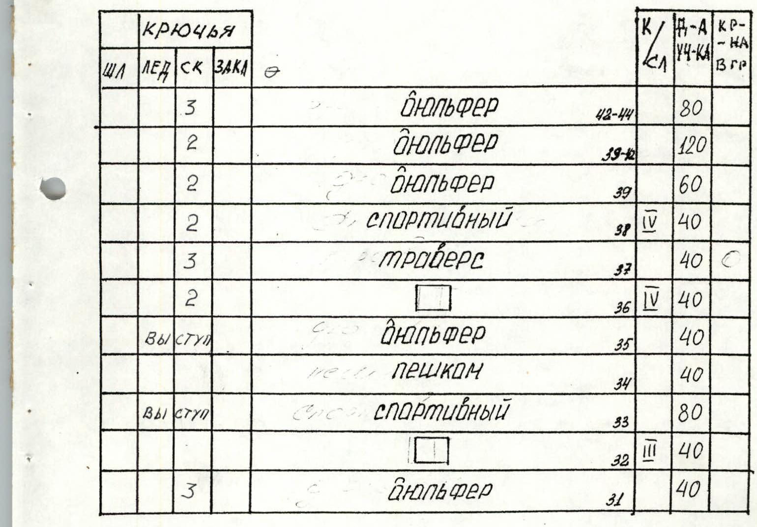
| Pitons | Belay | ICE | ROCK | CAM | Diff. level | Section length | Steepness |
|---|---|---|---|---|---|---|---|
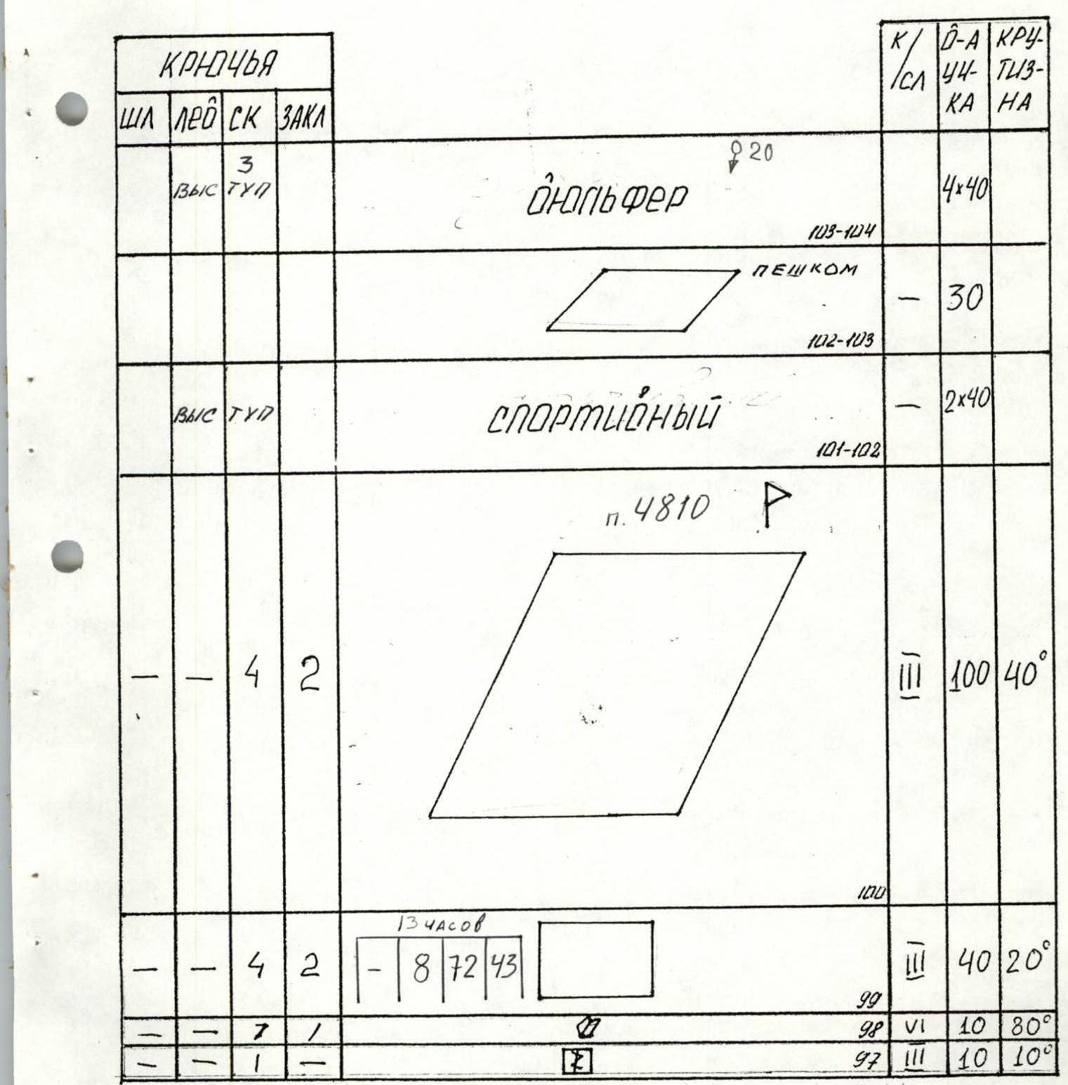
| – | – | 3 | – | rappel | 80 | ||
| – | – | 2 | – | rappel | 120 | ||
| – | – | 2 | – | rappel | 60 | ||
| – | – | 2 | – | 4 | sport | 40 | |
| – | – | 3 | – | traverse | 40 | ||
| – | – | 2 | – | 4 | 40 | ||
| Ledge | – | – | – | – | rappel | 40 | |
| – | – | – | – | walking | 40 | ||
| Ledge | – | – | – | – | sport | 80 | |
| – | – | – | – | 3 | 40 | ||
| – | – | 3 | – | rappel | 40 |
| Belay | ICE | ROCK | CAM | Diff. level | Section length | Steepness |
|---|---|---|---|---|---|---|
| – | 5 | 8 | – | 5 | 45 | 70° |
| – | 3 | 1 | – | 4 | 10 | 45° |
| – | 7 | 4 | – | 5 | 45 | 75° |
Ledge
| Belay | ICE | ROCK | CAM | Diff. level | Section length | Steepness |
|---|---|---|---|---|---|---|
| – | – | – | – | rappel | 45 80° | |
| – | 3 | 2 | – | 4 | 20 | 60° |
| – | 30 | 6 | – | 6 | 2x45 | 80° |
12.5 hours
| Belay | ICE | ROCK | CAM | Diff. level | Section length | Steepness |
|---|---|---|---|---|---|---|
| – | 20 | 15 | – | 6 | 2x45 | 70° |
| – | 3 | 1 | – | 4 | ||
| – | 6 | 7 | – | 4 | 50 | 40° |

| Belay | ICE | ROCK | CAM | Diff. level | Section length | Steepness |
|---|---|---|---|---|---|---|
| – | 9 | 6 | – | 5 | 50 | 75° |
| – | 4 | 1 | – | 4 | 40 | 50° |
| – | 3 | 4 | 2 | 4 | 40 | 60° |
| – | 20 | 10 | – | 5 | 2x45 | 65° |
| – | 17 | 15 | – | 5 | 2x45 | 30–70° |
| – | 9 | 4 | – | 5 | 45 | 80° |
Ledge
| Belay | ICE | ROCK | CAM | Diff. level | Section length | Steepness |
|---|---|---|---|---|---|---|
| – | 3 | 7 | 3 | 5 | 10 | 70° |
| – | 2 | 6 | 1 | 5 | 45 | 60° |
| – | 4 | 1 | – | 4 | 45 | 60° |
| – | 6 | 3 | – | 3 | 45 | – |
| – | – | – | – | 3 | 45 | – |
| Belay | ICE | ROCK | CAM | Diff. level | Section length | Steepness |
|---|---|---|---|---|---|---|
| – | – | 3 | – | rappel | 3х40 | |
| – | 8 | 2 | – | 5 | 40 | 60° |
| – | – | 1 | – | 3 | walking | 60 |
Ledge p. 4750
| Belay | ICE | ROCK | CAM | Diff. level | Section length | Steepness |
|---|---|---|---|---|---|---|
| – | – | – | – | rappel | 40 |
12 hours
| Belay | ICE | ROCK | CAM | Diff. level | Section length | Steepness |
|---|---|---|---|---|---|---|
| – | 5 | 2 | – | 3 | 40 | 30° |
| – | 5 | 7 | – | 4 | 90 | 40° |
| Belay | ICE | ROCK | CAM | Diff. level | Section length | Steepness |
|---|---|---|---|---|---|---|
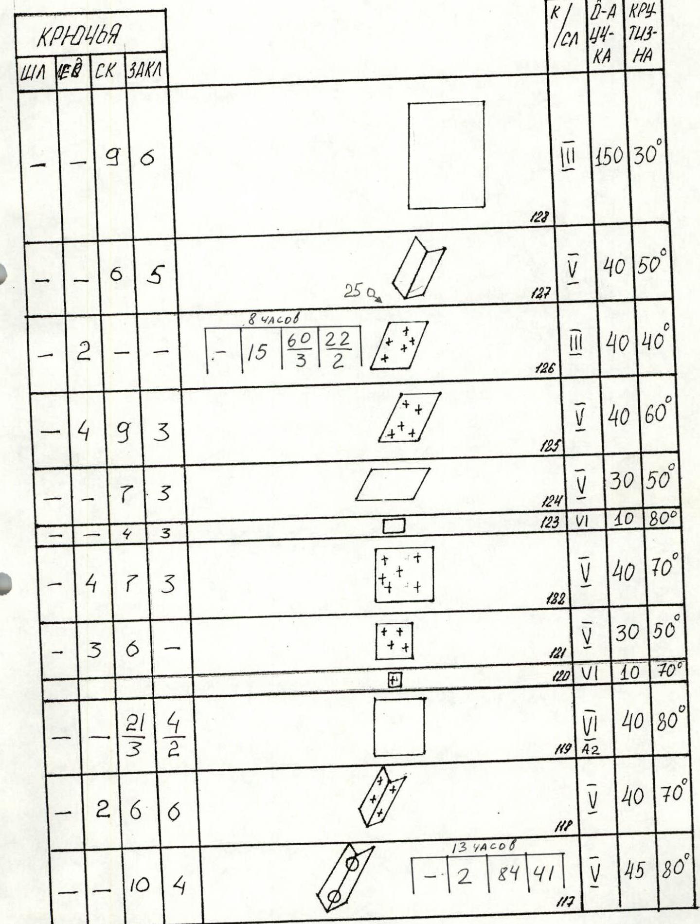
| – | 5 | 2 | – | 6 | 15 | 80° |
| – | 3 | 4 | 2 | 4 | 60 | 45° |
| – | 5 | 3 | – | 4 | 40 | 15° |
12 hours
| Belay | ICE | ROCK | CAM | Diff. level | Section length | Steepness |
|---|---|---|---|---|---|---|
| – | 8 | 38 | 120 | 5 | 15 | 65° |
| – | 1 | 1 | – | 3 | 25 | 30° |
| – | 1 | 2 | – | 3 | 40 | 40° |
| – | 1 | 1 | – | 3 | 25 | 20° |
| – | 4 | 3 | 1 | 3 | 55 | 40° |
| – | 7 | 5 | – | 5 | 40 | 60° |
| – | 3 | 1 | – | 5 | 20 | 30° |
| – | 5 | 3 | – | 5 | 25 | 70° |
| – | 4 | 2 | – | 5 | 20 | 60° |
| – | 6 | 3 | – | 5 | 30 | 70° |
| – | 1 | 1 | – | 5 | 15 | 30° |
| Belay | ICE | ROCK | CAM | Diff. level | Section length | Steepness |
|---|---|---|---|---|---|---|
| – | 9 | 4 | – | 5 | 40 | 70° |
| – | 2 | 4 | 3 | 4 | 40 | 30° |
| – | 4 | – | – | 5 | 40 | 40° |
| – | 4 | 3 | – | 4 | 40 | 55° |
| – | 6 | 4 | – | 5 | 45 | 65° |
| – | 5 | 4 | – | 4 | 45 | 20° |
| – | – | – | – | 5 | 10 | 90° |
| – | 3 | 1 | – | 5 | 45 | 60° |
| – | 1 | – | – | 5 | 15 | 80° |
| – | 2 | 5 | 3 | 4 | 5 | 30° |
| – | 3 | 3 | – | 5 | 40 | 80° |
| – | 6 | 4 | – | 6 | 10 | 90° |
| – | 5 | 4 | – | 5 | 35 | 60° |
| – | – | – | – | 5 | 40 | 30° |
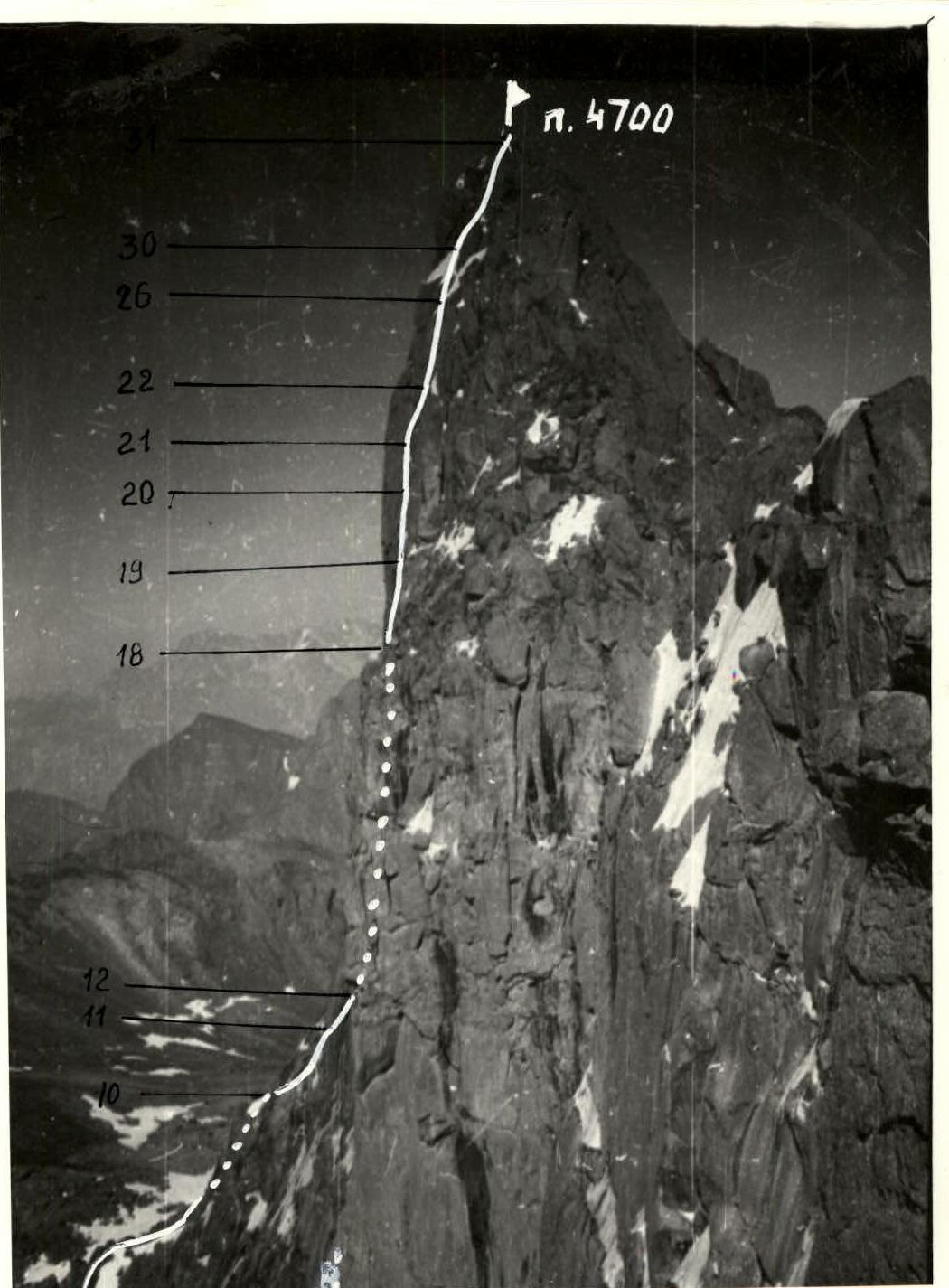
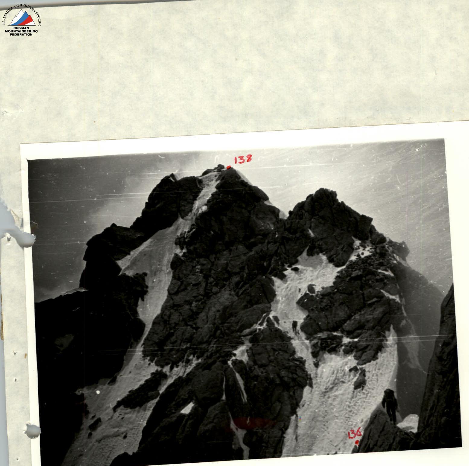
Profile of the route to p. 4700. Taken on 07.29.1990 from p. 4750. H=4500. Camera «Smena». MAP-SCHEME T. 2.
| Belay | ICE | ROCK | CAM | Diff. level | Section length | Steepness |
|---|---|---|---|---|---|---|
| – | 6 | 3 | – | 6 | 45 | 80° |
| – | 10 | 3 | – | 5 | 45 | 80° |
| – | 9 | 7 | – | 4 | 80 | 45° |
| – | 3 | 1 | – | 5 | 10 | 80° |
| – | 10 | 6 | – | 3 | 5х40 | 25° |
| – | 13 | 7 | – | 6 | 45 | 85° |
| – | 2 | 2 | – | 3 | 15 | 45° |
| – | 4 | 2 | – | 4 | 10 | 60° |
| – | 2 | 6 | – | 5 | 20 | 45° |
| – | 9 | 5 | – | 5 | 45 | 75° |
| – | 8 | 5 | – | 5 | 40 | 70° |
| – | – | – | – | 3х40 | 10° |
| Belay | ICE | ROCK | CAM | Diff. level | Section length | Steepness |
|---|---|---|---|---|---|---|
| – | 9 | 0 | – | 3 | 150 | 30° |
| – | 6 | 5 | – | 5 | 40 | 50° |
8 hours
| Belay | ICE | ROCK | CAM | Diff. level | Section length | Steepness |
|---|---|---|---|---|---|---|
| – | 2 | – | – | 3 | 40 | 40° |
| – | 4 | 9 | 3 | 5 | 40 | 60° |
| – | 7 | 3 | – | 5 | 30 | 50° |
| – | 4 | 3 | – | 6 | 10 | 80° |
| – | 4 | 7 | 3 | 5 | 40 | 70° |
| – | 3 | 0 | – | 5 | 30 | 50° |
| – | 21 | 4 | 2 | 6 | 10 | 70° |
| – | 2 | 6 | 6 | 6 | 40 | 80° |
| – | 10 | 4 | – | 5 | 40 | 70° |
13 hours
| Belay | ICE | ROCK | CAM | Diff. level | Section length | Steepness |
|---|---|---|---|---|---|---|
| – | 2 | 84 | 41 | 5 | 45 | 80° |
| Belay | ICE | ROCK | CAM | Diff. level | Section length | Steepness |
|---|---|---|---|---|---|---|
| – | 5 | – | – | 4 | 40 | 45° |
| – | 4 | – | – | 4 | 40 | 45° |
| – | 6 | 1 | – | 3–5 | 40 | 60° |
| – | 6 | – | – | 3 | 120 | 40° |
| – | 5 | 1 | – | 3 | 120 | 40° |
| – | 2 | 4 | – | 4 | 50 | 40° |
| – | 2 | 2 | – | 3 | 60 | 25° |
| – | 8 | 2 | – | 5 | 40 | 65° |
| – | 6 | 6 | – | 5 | 40 | 75° |
Total pitons:
| Belay | ICE | ROCK | CAM |
|---|---|---|---|
| 6 | 108 | 460 | 314 |
| 4 | 15 | 7 | – |
*Pitons used for rappelling are not included in the total count. Total climbing hours — 143.
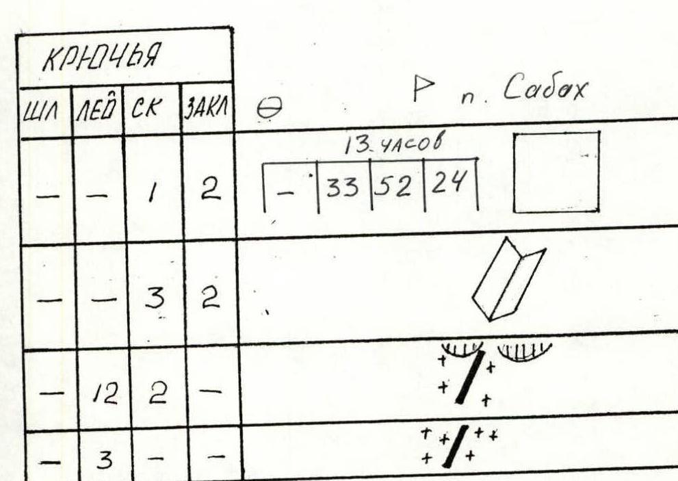
P. Sabakh
13 hours
| Belay | ICE | ROCK | CAM | Diff. level | Section length | Steepness |
|---|---|---|---|---|---|---|
| – | 1 | 2 | – | 3 | 40 | 30° |
| – | 3 | 2 | – | 4 | 40 | 50° |
| – | 12 | 2 | – | 4 | 250 | 30° |
| – | 3 | – | – | 5 | 20 | 60° |
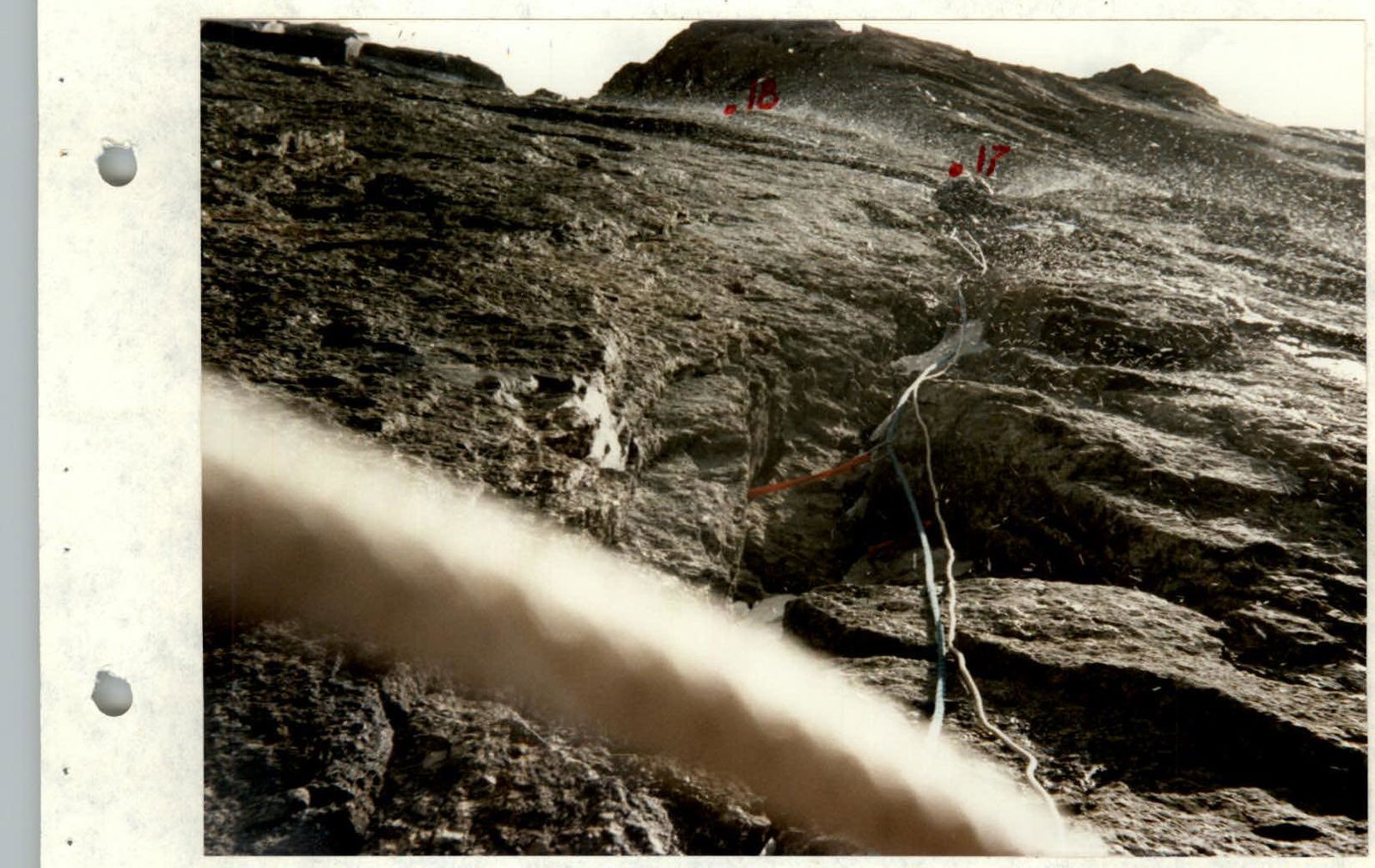
Section R16–R17. 07.26.
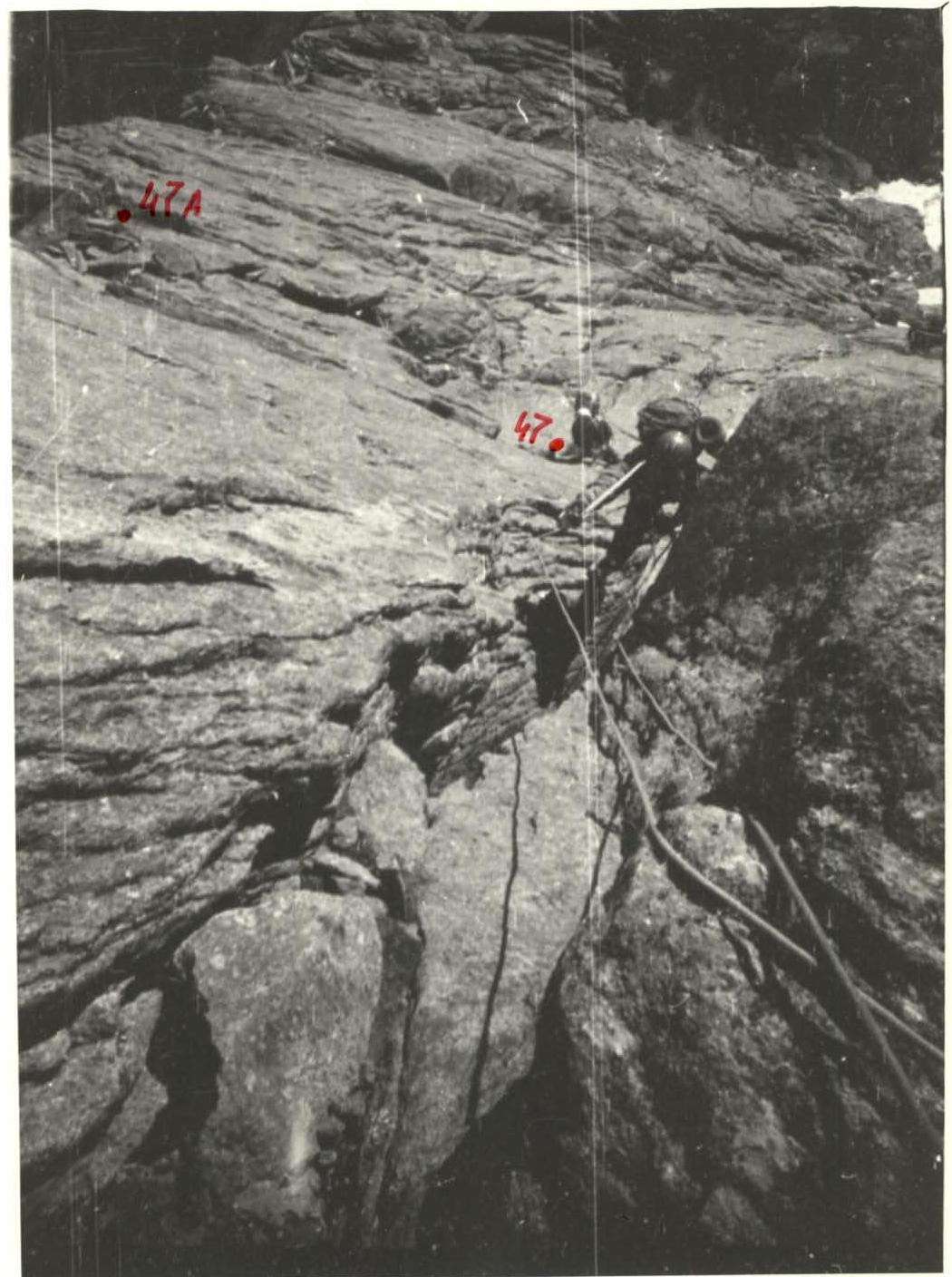
Start of sections R47–R48. Below are sections R44–R46. 07.29.
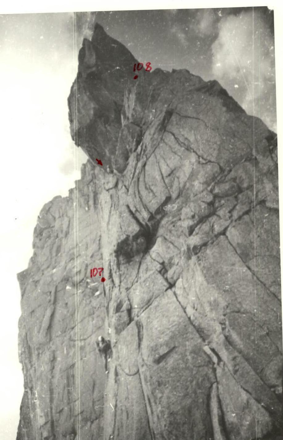
Sections R106–R108. 08.01.
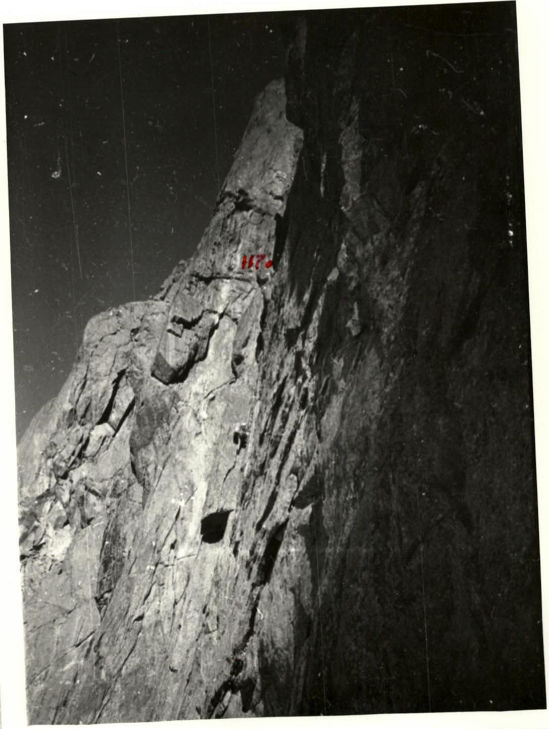
Sections R116–R118. 08.03.
Ridge p. Sabakh, sections R135–R137. 08.03.