
PASSPORT
I. Technical class. 2. Pamir-Alay, Turkestan Ridge, Ak-su gorge. 3. Peak "4690" (50th anniversary of the Moscow Spartak), via the North slope. 4. Assumed 4B category of difficulty (second ascent). 5. Height difference — 700 m. Length — 1100 m. Length of sections with 5th category of difficulty — 330 m. Average steepness: route — 40°, ridge part — 15°, ice part — 47°, sections with 5th category of difficulty — 53°. 6. Pitons hammered for insurance rock — ice — 80 7. Number of travel hours — 7 h 30 min, day I. 8. Participants: Kashcheev Vladimir Nikolaevich — 1st sports category Selivanov Yuri Fedorovich — Candidate Master of Sports 9. Coach: Pshakin Gennady Maksimovich — Master of Sports. 10. Departure to the route: August 20, 1984. Summit — August 20, 1984. Return — August 20, 1984.
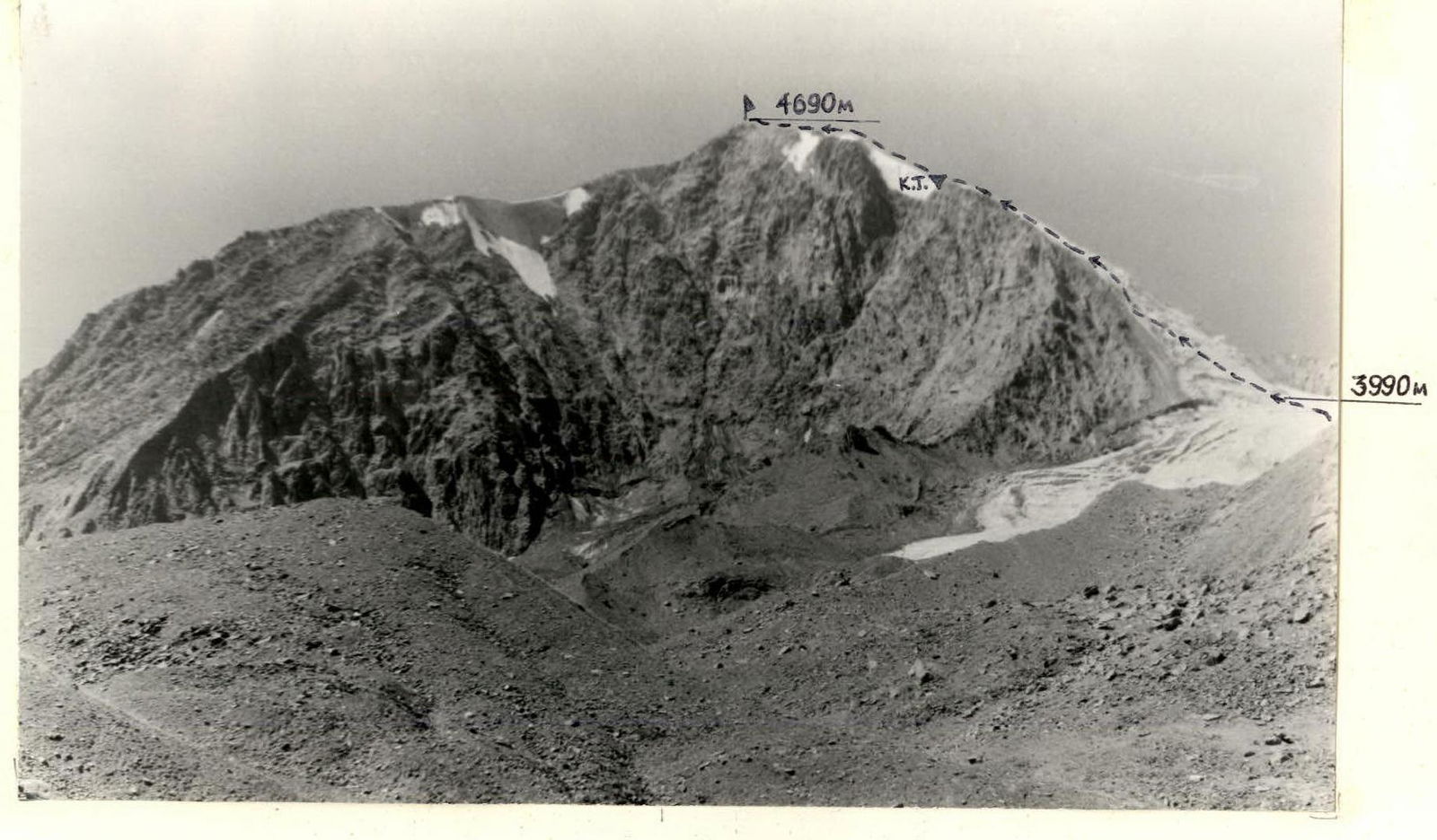
Fig. 1. General photo of the peak 50th anniversary of the Moscow Spartak (peak "4690"). Camera point number 1, August 19, 1984, 14:00, L2.2 km, h3700 m, PANCOLAR, f = 50 mm.
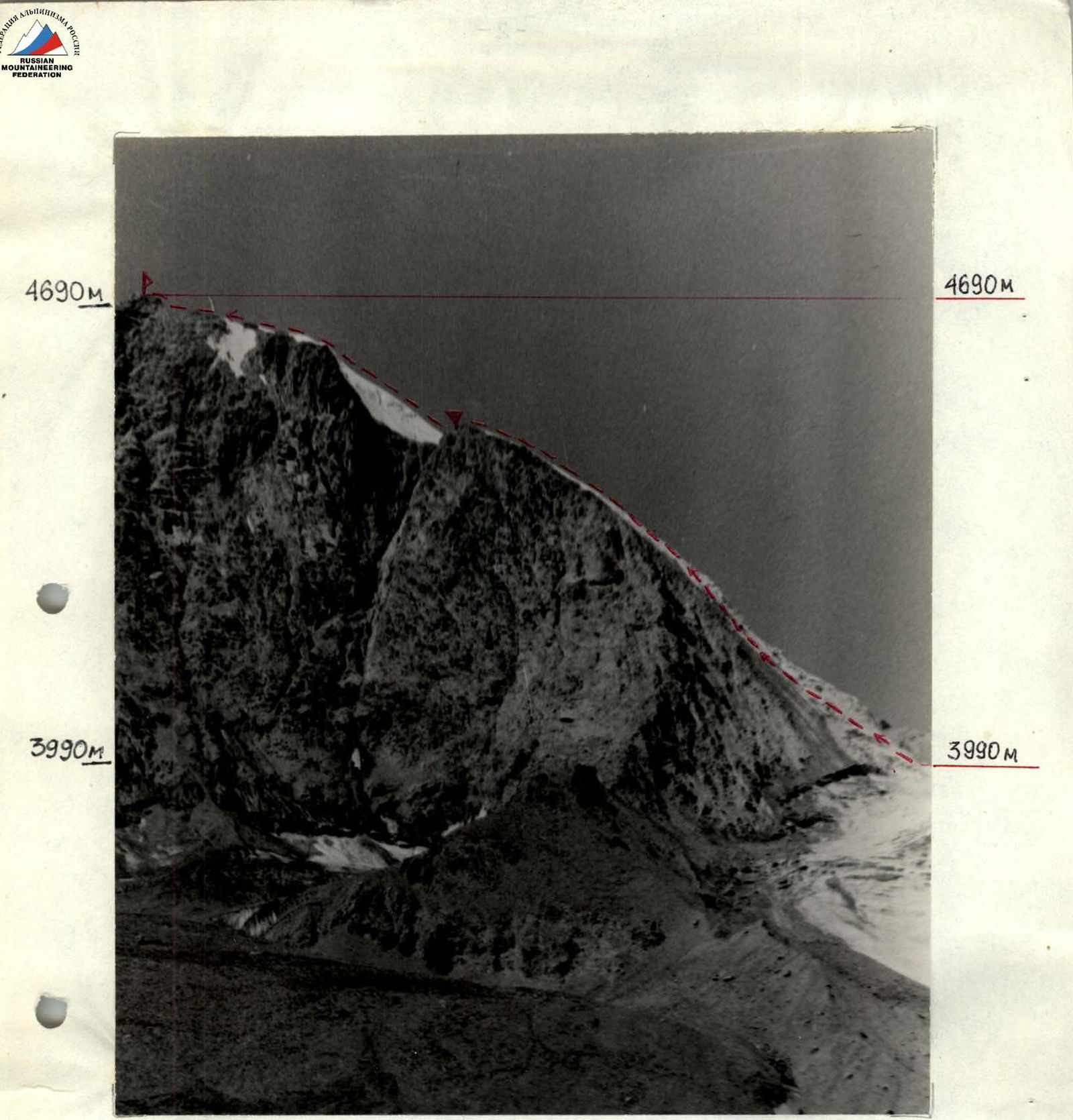
Fig. 3. Photo of the route profile from the left. August 19, 1984, 14:30, L2 km, h3900 m, camera point number 2, PANCOLAR, f = 50 mm.
Brief overview of the ascent area, approach path
The ascent area is located in the eastern part of the Turkestan Ridge, Pamir-Alay. The main part of the peaks has a height of around 5000 m. The highest point of the area is Peak Ak-su (5355 m). The northern slopes of the peaks in the area are heavily glaciated. The snow line height reaches 3700–4000 m. The southern slopes are often heavily destroyed.
Approach to the route
From the "Alay" tourist center, cross the Ak-su river by bridge and move into the Kara-su gorge. You can:
- immediately cross to the left bank of the Kara-su river (orographic) and move upstream to the stream flowing from the glacial cirque formed by peaks 4690, 4784, and 40-letiya Pobedy;
- move along the right bank of the Kara-su river and cross it either in the middle of the approach at the koshi, or in the immediate vicinity of the campsite, where the Kara-su river is formed by streams flowing from the glacier under peak 50II and from the glacier under peak 4690.
From the camp — 4–5 hours.
From the confluence, ascend along the stream towards the slopes of peak 40-letiya Pobedy (approximately 30 minutes). Here you can set up a campsite.
It is characteristic that a moraine begins near the campsite, which leads to the eastern slopes of peak 40-letiya Pobedy.
From the campsite, move up the moraine to a rock wall. The rock wall — resembling "sheep's foreheads" (~20 m) — is overcome by free climbing. Then move along the rocky talus slope until the glacier, which remains on the left during the ascent, becomes gentle. At this point, descend onto the glacier and along its gentle part approach the route. The glacier in its gentle part is of an open type.
Tactical actions of the team
During the training cycle of classes and ascents to peaks of 2nd, 4th, and 5th categories of difficulty, a team of two was formed:
-
- Kashcheev V.N.
-
- Selivanov Yu.F.
As a result of the preparation:
- visual study of the route during previous ascents;
- consultations and presence at the route discussion with the first ascenders, the team, having realistically assessed the difficulties of the route and their own capabilities, came to the conclusion that the route could be completed without an overnight stay on the route. In good weather, it was expected to take ~7–8 hours, and in case of worsening weather — ~10–12 hours. A tactical plan was developed, which the team strictly adhered to on the route.
Movement on the route occurred as follows:
- departure from the campsite — 7:30;
- arrival at the route — 9:00 (communication with observers);
- on the route up to the control cairn, movement was carried out alternately with piton insurance. On sections R1–R3, observation was organized for the rockfall-prone slope. On the same section, for quick passage through crevasses, visual and signal communication was established with observers.
The high pace of movement and safe passage on the route were due to:
- The team's coordination;
- High qualification of the team;
- Proper selection of equipment;
- Good weather during the ascent.
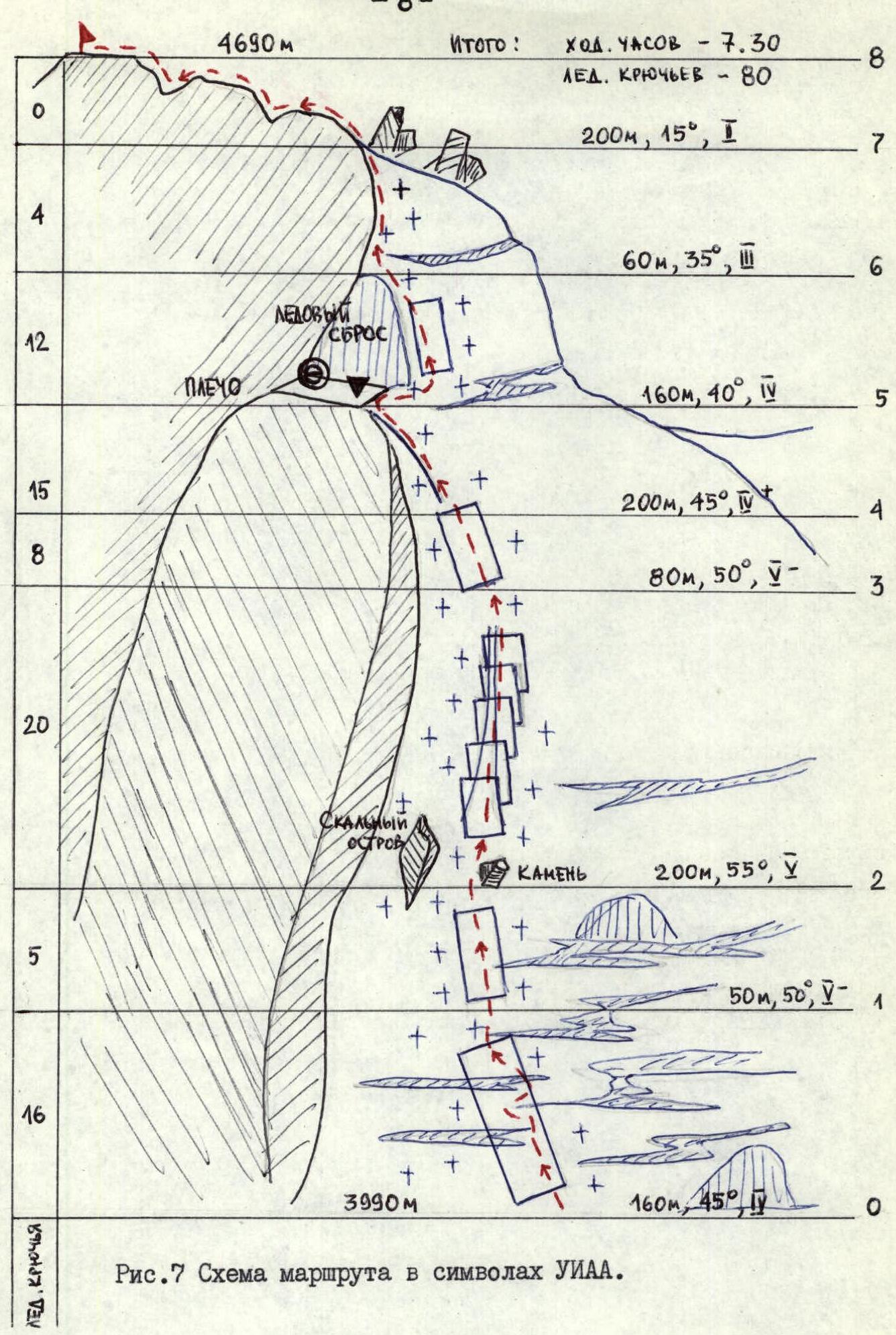
Fig. 7. Scheme of the route in UIAA symbols.
Brief explanation of the route sections
R0–R1. Ice slope, mostly without crevasses. Ascend straight up. Firm snow is encountered in places. Insurance is good. R1–R2. Section of the slope heavily cut by crevasses. Typically, ascend left-upwards. Some crevasses are bypassed on the right via snow bridges. A good landmark for movement is a large stone protruding from the ice and a nearby rocky outcrop. Do not enter the left part of the slope too much! It is rockfall-prone! R2–R3. From the stone, move upwards along a vaguely defined couloir, which represents a system of small icefalls, convenient for organizing insurance. In some places, the slope reaches ~70° steepness. In the lower part of the section — rockfall-prone! R3–R4. Ice slope in the upper part, representing a firm snow slope. Insurance is good. R4–R5. The slope gradually flattens into a platform, where a control cairn is located. Here you can set up a campsite. R5–R6. Steep firm snow slope, bypassing an ice drop. Ascend on the right part of the drop. Move from right to left. In the upper part, an ice crevasse is bypassed on the left, almost on the rocks. R6–R7. Snow slope leading to the pre-summit ridge. R7–R8. Heavily destroyed rocky ridge. Move very cautiously.