Ascent Passport
- Ascent class — technical
- Ascent area — Pamir-Alai, Turkestan Range
- Peak (its height, route) — T. Sadykov Peak 4432 m via N.E. ridge
- Expected category — 2B (rocky terrain)
- Route characteristics Height difference 600 m, total route length 1100 m, average slope 35°
- Number of travel hours — 5 hours
- Number of protection pitons — 2
- Number of overnight stays — none
- Full name of the leader, participants, and their qualifications Leader: Pyshkin A.V. — II sports category; Participants: Didenko V.P. — II sports category, Vaisberg E.I. — I sports category, Sytnik D.N. — II sports category.
- Team coach: Candidate Master of Sports Prikhodchenko A.M.
- Date of departure on the route — August 12, 1984
Date of return — August 12, 1984

Brief description of approaches
From the base camp at Djortash meadow:
- Cross the bridges over Akh-su and Kara-su rivers.
- Follow the trail for 2 hours.
- Pass by Kosh.
- Reach the first lateral valley with a stream.
At the green terrace along the stream — overnight stay to the right of the riverbed.
From the overnight stay:
- Cross the stream.
- Ascend via the slopes overgrown with juniper and grass.
- Stick to the right part of the valley with a stream for 1 hour.
- Reach the base of the Rocky Spires.
The Spires are bypassed on the right, leading to the start of the route on the northeast ridge.
UNAA Scheme
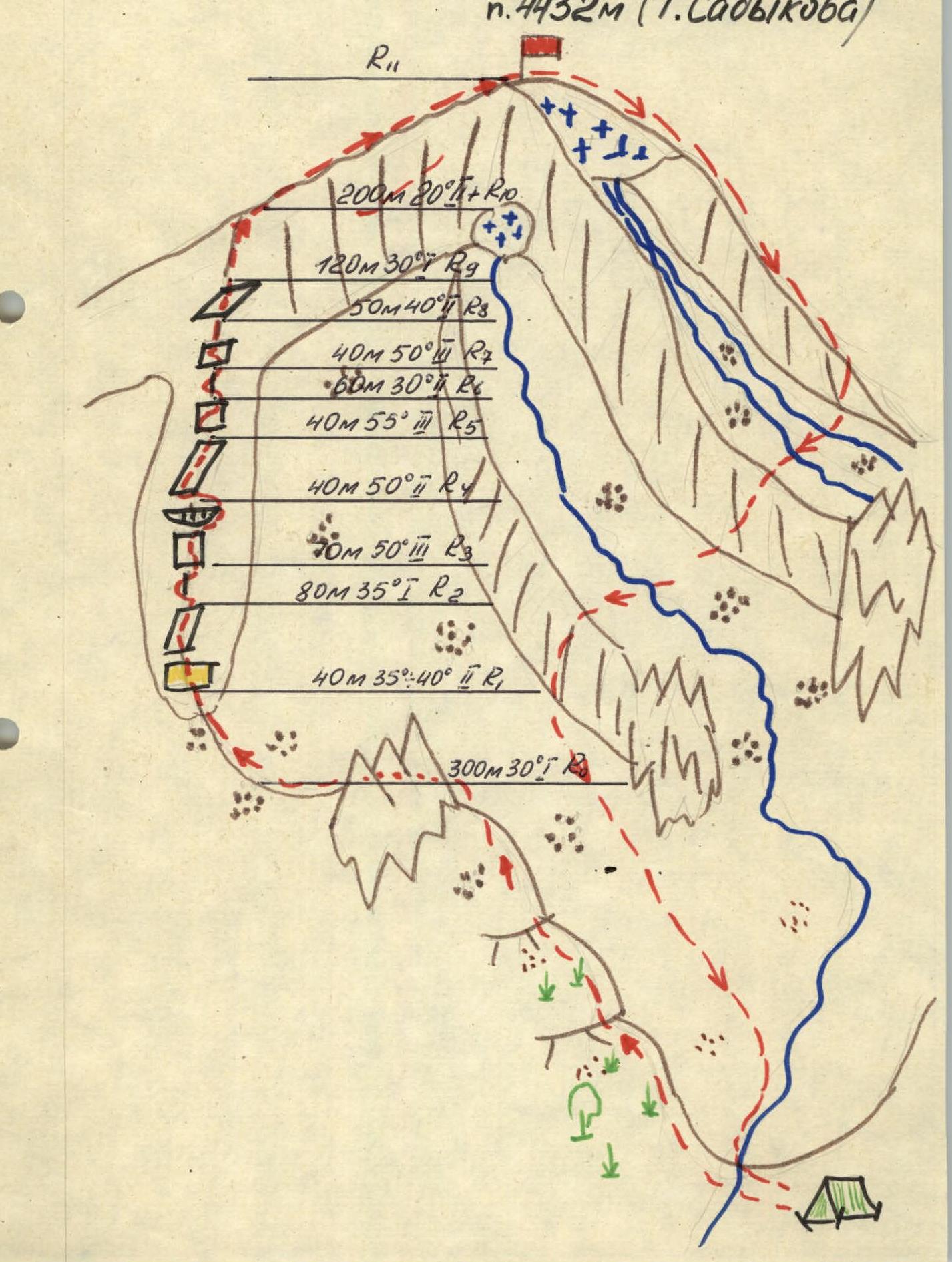
Main characteristics of the route by sections
| Date | Designation | Average slope | Length in meters | Difficulty | Terrain characteristics | Condition | Weather conditions | Pitons |
|---|---|---|---|---|---|---|---|---|
| 12.08.1984 | R0 | 30° | 300 m | I | Scree ridge | scree | good | — |
| R1 | 39–40° | 40 m | II | Rusty wall, inclined slab | monolith | — n — | — | |
| R2 | 35° | 80 m | I | Ridge with rusty rocks | ridge | — n — | — | |
| R3 | 50° | 70 m | III | Inclined wall, overhang | monolith | — n — | — | |
| R4 | 50° | 40 m | II | Slab | monolith | — n — | — | |
| R5 | 55° | 40 m | III | Inclined wall, loose rocks | monolith | — n — | — | |
| R6 | 30° | 60 m | II | Sharp, destroyed ridge | ridge | — n — | — | |
| R7 | 50° | 40 m | III | Slab | monolith | — n — | I | |
| R8 | 40° | 50 m | II | Slab | monolith | — n — | I | |
| R9 | 30° | 120 m | I | Scree ridge | scree | — n — | — | |
| R10 | 20° | 200 m | II | Sharp, narrow rocky ridge with steep drops on both sides | monolith | — n — | — |
Brief explanation of the main route characteristics table
R0 — scree ridge, simultaneous movement. R1 — rope team movement. Bypass the rusty wall on the right via ledges and slabs and exit onto the ridge. R2 — along the ridge of slabs, approach under the overhanging wall of the gendarme. Protection via protrusions. R3 — straight up under the overhang, then bypass the gendarme:
- first to the right along a ledge with sharp spires;
- then via dry rocks into a pocket under the gendarme and exit into a narrow crevice behind it. Protection via protrusions.
R4 — straight up via monolithic slabs under the wall with a narrow, sloping ledge going from left to right. Caution: loose rocks. R5 — along the ledge up to the right to a sharp ridge, protection via protrusions. R6 — along the right side of the sharp, destroyed ridge to a col before a rise of monolithic slabs. R7 — up via slabs, straight, piton protection. R8 — up via slabs, piton, rope. R9 — simultaneous movement until the junction of two ridges. R10 — exit onto a sharp, narrow summit ridge. Caution: steep drops on both sides. Simultaneous movement on a shortened rope with protection via protrusions and cracks on different sides of the ridge.
Note: in case of wet rocks — movement along the left part of the ridge, sticking to its sharp edge. Alternate movement, pitons.
Descent from the summit via the North Ridge (do not deviate to the right buttress) until it becomes less steep:
- initially via destroyed rocks;
- further to the left of them via snow, exiting onto scree — the beginning of the North Ridge;
- further along the North Ridge until its gentle part;
- from there, traverse to the right across streams, via a scree ridge, and further via scree to the bivouac.
List of necessary equipment
| Main rope | 2 × 40 m |
| Carabiners | 16 pcs. |
| Harness, belt, sling | 4 pcs. |
| Self-belay loops | 4 pcs. |
| Pitons | 10 pcs. |
| Hammer | 2 pcs. |
| Helmet | 4 pcs. |
| Ice axe | 4 pcs. |
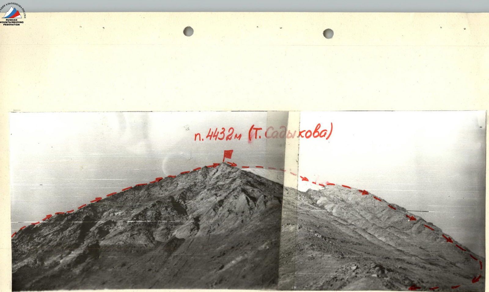
General view of the peak and the 2B route via the N.E. ridge