I. Category — technical 2. Pamir-Alay, Kara-Su valley 3. Peak 4217 via left spur of East ridge 4. Proposed category 3A, first ascent 5. Height difference 600 m. Total length 1150 m. Length of category III sections 400 m. 6. Average slope of the route 50°. 7. Average slope of the key section 70°. 8. Pitons driven: rock — 17. 9. Climbing hours 1.2 (from bivouac). 10. Bivouacs on the route present. 11. Leader — Kraynov N.P. — Master of Sports.
Participants:
- Bogdanov V.I. — Candidate for Master of Sports
- Boronin N.V. — 1st sports category
- Orlov V.F. — 1st sports category
- Romanov S.B. — 1st sports category
-
Coach — KRAINOV NIKOLAI PETROVICH.
-
Departure to the route — July 8, 1983, summit — July 8, 1983, return — July 8, 1983.
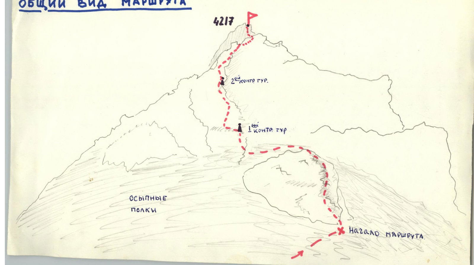
Route description to Peak 4211 via East ridge
From the bivouac on the right bank of the Kara-Su river under the slopes of Petrovgradets, we move towards the right spur of the eastern ridge of Peak 4217, bypassing its lower part to the right along the grassy slope and scree, and reach it where it starts to gain steepness — 1.5 hours from the bivouac. There is an initial cairn.
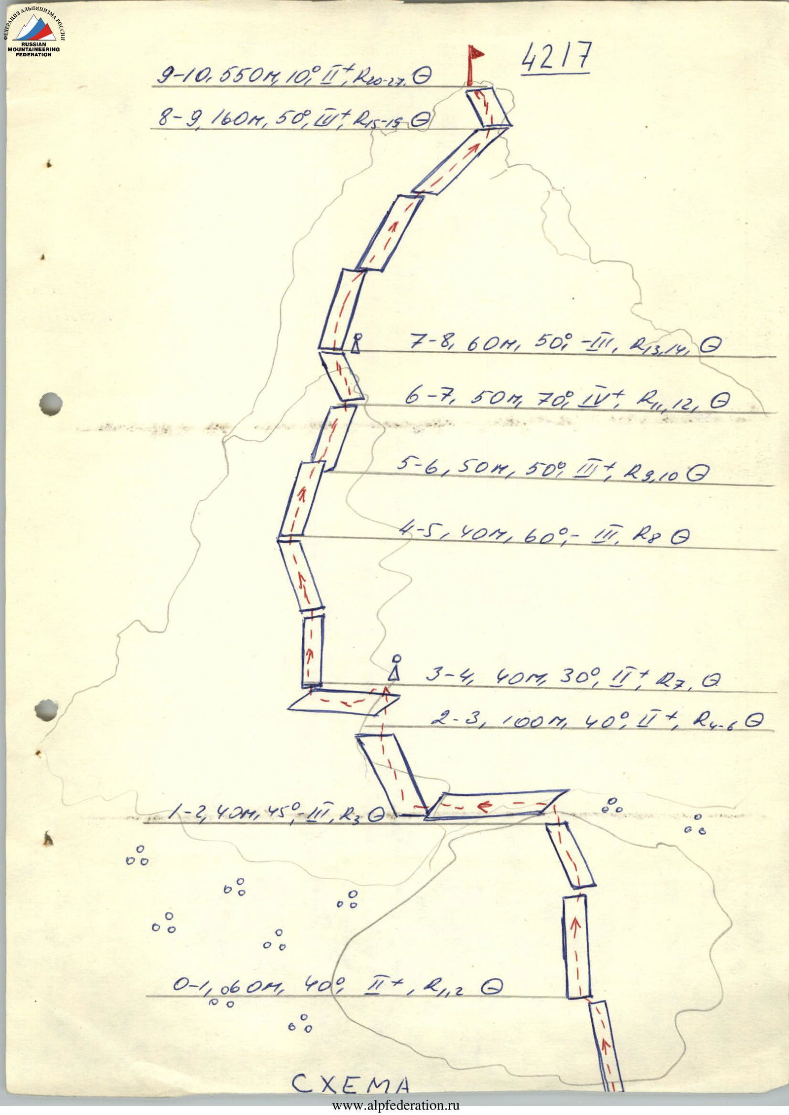
R0–R1: one and a half ropes climbing simultaneously, 40°, 1–2. Then one rope climbing with the use of a piton, 45°, 2–3. Three ropes along scree ledges under the wall with a vertical crack in the upper part of gray color, 40°. Under it, a control cairn No. I is built (one hour from the lower route). Altimeter reading — 3750 m.
R3–R4: From cairn I, one rope to the left along a green ledge.
R4–R5: Then to the right along the crack, 15 m of climbing, 2 pitons, then along the slabs to the left upwards to a small ledge, 4 pitons, 60°.
R5–R6: From the ledge upwards along smooth slabs with cracks under a small overhang, chip, 50 m (3 pitons), 50°.
R6–R7: Then along a gray monolithic slab, 75°, 6 m of climbing, stacked upwards slightly to the left, then to the right with piton protection, 1 rope to a small ledge, 5 pitons, 70°.
R7–R8: From the ledge along the slabs, a crack onto ledges, upwards to the left onto a ledge. On it, control cairn No. 2 (the entire section — 1.5 ropes, 50°, 2 pitons), we were there at 17:00.
R8–R9: From the cairn to the left upwards to the right — exit to the ridge, 4 ropes. Protection using the terrain.
R9–R10: After a small dip along the ridge with a slight gain in height, we reach the summit, 9–12 ropes. The summit is rocky, composed of blocks, not sharply distinguished from the ridge. We were at the summit at 18:45. Descent back along the ridge — 1 rope and to the right along scree to the bivouac on the Kara-Su bank — 2 hours!
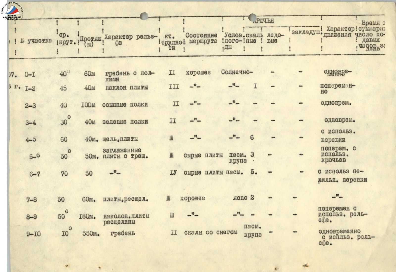
| Section No. | Average slope | Length (m) | Terrain characteristics | Section category | Route condition | Conditions (weather) | Pitons: rock | Pitons: ice | Pitons: placements | Movement characteristics | Total climbing hours for the day |
|---|---|---|---|---|---|---|---|---|---|---|---|
| R0–R1 | 40° | 60 m | ridge with ledges | 2 | good | Sunny | simultaneously | ||||
| R1–R2 | 45° | 40 m | inclined slabs | 3 | good | Sunny | 1 | alternately | |||
| R2–R3 | 40° | 100 m | scree ledges | 2 | good | Sunny | simultaneously | ||||
| R3–R4 | 30° | 40 m | green ledges | 2 | good | Sunny | simultaneously using a rope | ||||
| R4–R5 | 60° | 40 m | crack, slabs | 3 | good | Sunny | 6 | alternately using a rope | |||
| R5–R6 | 50° | 50 m | smooth slabs with cracks | 3 | loose slabs, cloudy, graupel | cloudy, graupel | 3 | alternately using pitons | |||
| R6–R7 | 70° | 50 m | smooth slabs with cracks | 4 | loose slabs, cloudy | cloudy | 5 | using a fixed rope | |||
| R7–R8 | 50° | 60 m | slabs, cracks | 3 | good | clear | 2 | using a fixed rope | |||
| R8–R9 | 50° | 180 m | inclined slabs, cracks | 3 | good | clear | alternately using terrain | ||||
| R9–R10 | 10° | 550 m | ridge | 2 | rocks with snow | cloudy, graupel | simultaneously using terrain |
General view of the route