
Ascent Passport
- Ascent class — technical
- Ascent area, ridge — Pamir-Alay, Turkestan
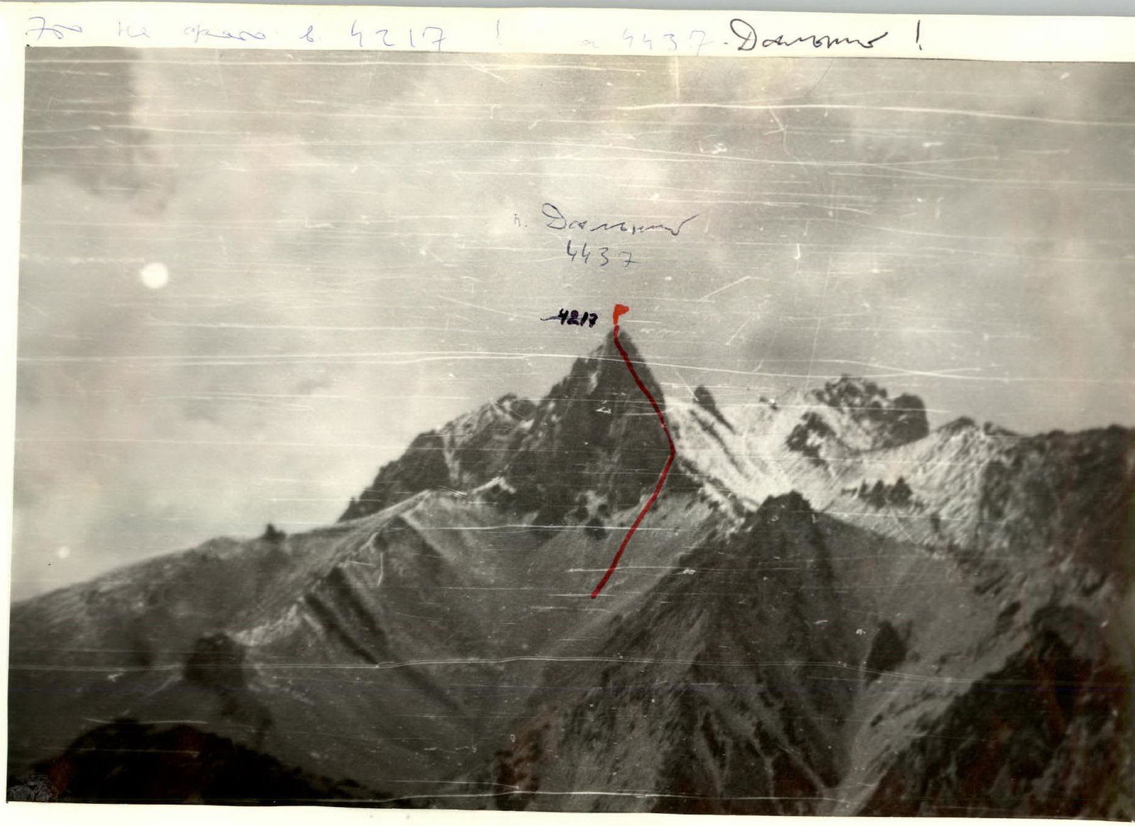
- Peak, its height, route — Peak 4217 (Dalniy) via North-Eastern wall
- Estimated difficulty category — 4A
- Route characteristics: height difference — 300 m, length of 5th difficulty category sections — 134 m, average steepness — 50°
- Pitons driven: for belay — 47, for creating I.T.O. — 1
- Number of travel hours — 9.3 hours
- Number of overnight stays and their characteristics — none
- Full name of the leader, participants, and their qualification: Barulin Boris Alexandrovich — MS Evstigneev Alexey Vladimirovich — I.p.
- Team coach: Troshchenko L.A.
- Date of departure and return: July 10–11, 1982
Brief description of the approach to the route
From the base camp at the confluence of the Belaya and AkSu rivers, descend to the confluence of the AkSu and KaraSu rivers and then along the trail along the left bank of the KaraSu River to the first tributary. There is a large kosch here. From the base camp — 1 hour. Further movement is first along the tributary to a small squeeze. Immediately after the squeeze to the right along the dry riverbed and scree slopes along the north-eastern ridge to the eastern slope of Peak 4217 (Dalniy) and then along a steep scree couloir (live scree), along rock outcrops to the saddle of the north-eastern ridge under the base of the north-eastern wall. Here, on a scree shelf, you can set up a tent. From the base camp — 4 hours.
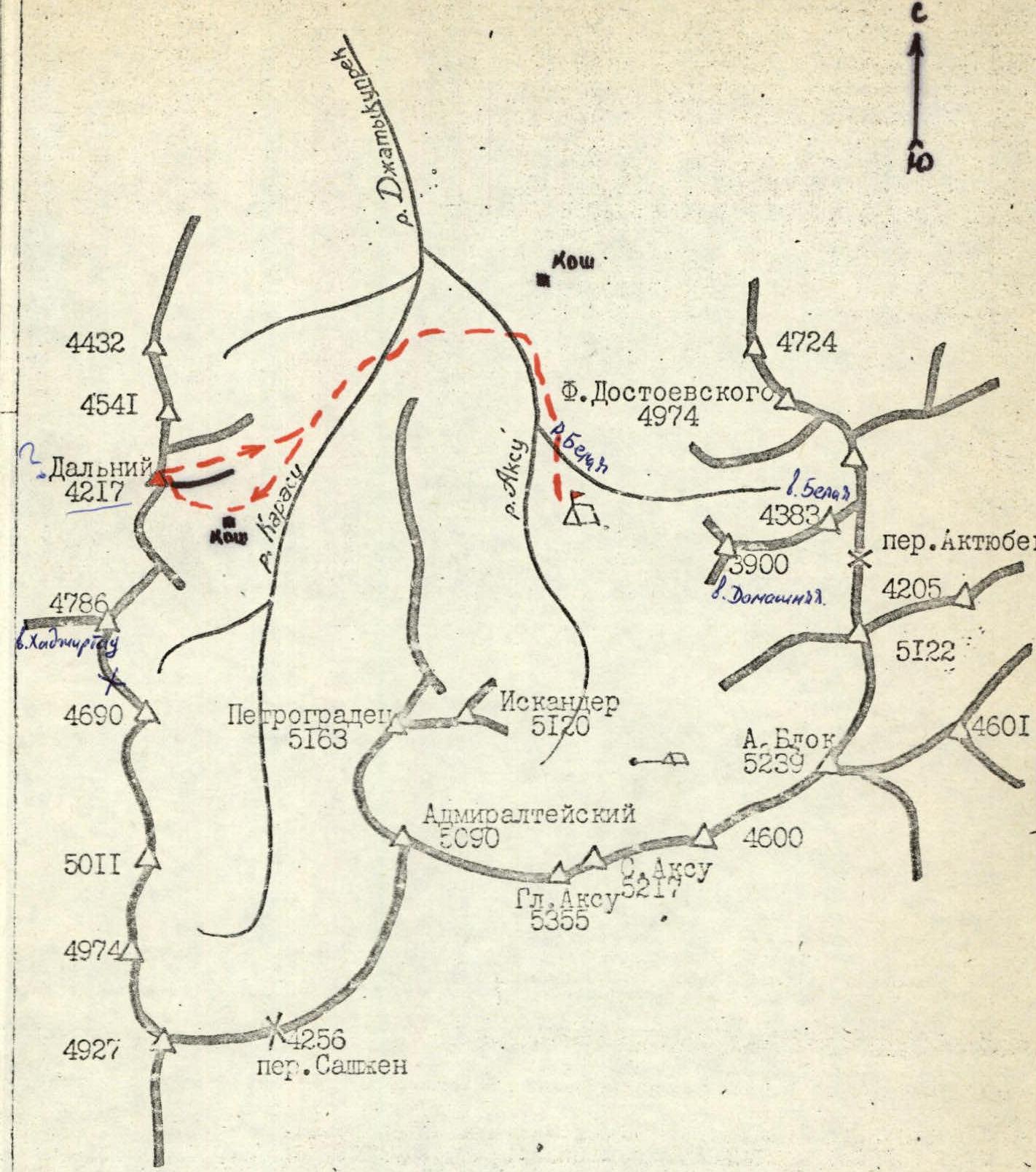
Map of the AkSu area. Turkestan ridge M 1:100000
Table of main characteristics of the ascent route
| DATE | DESIGNATION | Average steepness, ° | Length, m | Terrain characteristics | Difficulty | Condition | Weather conditions | PITS: rock | PITS: chocks | PITS: ice |
|---|---|---|---|---|---|---|---|---|---|---|
| 11.07 8:00 | R0–R1 | 80 | 10 | crack | 4 | destroyed | good | 1 | 1 | |
| R1–R2 | 60 | 25 | walls, shelves, inner corner | 3 | monolith | 2 | ||||
| R2–R3 | 50 | 40 | inner corner, slab | 3 | monolith | " | 3 | 2 | ||
| R3–R4 | 50 | 40 | slabs, couloir | 3 | snow-covered | " | 5 | – | ||
| R4–R5 | 60 | 40 | walls, inner corner | 4 | monolith | " | 6 | 1 | ||
| R5–R6 | 80 | 20 | wall | 5 | monolith | " | 4 | |||
| R6–R7 | 70 | 20 | inner corner | 4 | monolith | " | 3 | 1 | ||
| R7–R8 | 60 | 40 | shelf, couloir | 3 | snow-covered | " | 4 | |||
| R8–R9 | 40 | 40 | slabs, "ram's foreheads" | 3 | snow-covered | " | 5 | 1 | ||
| R9–R10 | 60 | 4 | wall | 4 | wet | " | 1 | |||
| R10–R11 | 50 | 40 | sloping shelf, couloir | 4 | snow-covered | " | 4 | – | 1 | |
| R11–R12 | 30 | 120 | ridge | 2–3 | destroyed | " | 2, ledges | |||
| SUMMIT REACHED AT 17:20 | 40 | 6 | 1 |
Brief explanations for the table of main route characteristics
Section R0–R1: Start of the route from the scree shelf to the right of the saddle. From it, up a vertical crack to a shelf. Section R1–R2: Then along gentle walls and an inner corner to an inclined scree shelf. Section R2–R3: Further up to the right along the inner corner and slab to a narrow scree shelf. Section R3–R4: From here, movement along the shelf to the right and up, crossing a snow-covered couloir (at the mouth of the couloir — icy rocks). Section R4–R5: Then along a system of small but steep walls and inner corners (live stones) we approach under the red rock wall with a small number of cracks (key point of the route). Section R5–R6: Up and to the left along the wall to the base of the inner corner. Section R6–R7: The smoothed inner corner is passed on friction. Section R7–R8: Further, a sloping narrow shelf leads to a snow-covered couloir. Section R8–R9: After the couloir, along snow-covered slabs and "ram's foreheads" we exit under overhanging rocks (the ridge is already close, here are the last difficulties). Section R9–R10: Overhanging rocks are bypassed to the right along a steep wet wall. Section R10–R11: Then, moving further to the right and up, we exit to the base of a snowy couloir. The couloir leads to a depression in the north-eastern ridge. Section R11–R12: From here to the summit along the ridge, overcoming several small gendarmes (about three ropes) with simultaneous belay. Descent towards the saddle of the northern ridge. Two 40 m rappels with rope retrieval and then simultaneously — a total of about six ropes. On the saddle, there are snow cornices to the east. We go around the cornices to the right along the rocks, and then simple scree slopes lead to the KaraSu gorge.

General view of the north-eastern wall from under the route
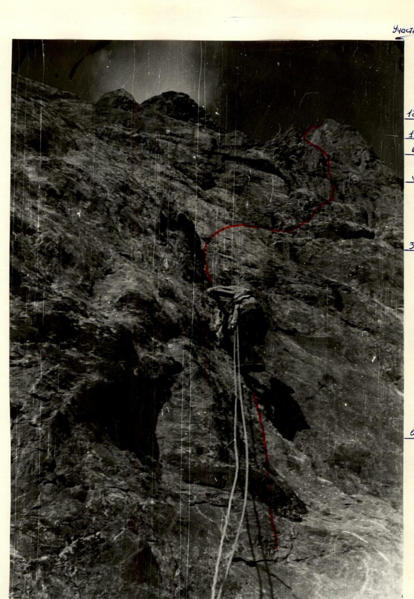
Sections R4–R5, R5–R6

Crack of the route in UIAA notation