I. Climbing category — rock
- Climbing area — Pamir, Turkestan Range, Ak-Su gorge.
- Peak — Anarov Peak, height 3998 m, ascent route along the southern counterfort and eastern ridge.
- Difficulty category — 6B
- Route characteristics:
- altitude difference 1150 m;
- length of sections: a) key sections — 75 m; b) along the ridge — 580 m; c) average steepness of the route — 45°; d) route is rocky.
- Pitons hammered for belay:
- rock pitons — 34;
- used wired elements — 15;
- bolted pitons — none;
Movement on the route — 8 hours.
- Total time including descent — 11 hours;
- approach — 2 hours
- descent — 1 hour
- Leader, participants, their qualification:
leader — Kondakov Evgeny Ivanovich, Master of Sports, participant — Shkola Natalia Ivanovna, category III. Date of departure on the route — July 19, 1984, time — 5:30. Return to the camp — July 19, 1984, 17:00.
Brief topographic description of the area, approach route
The climbing area is located in the eastern part of the Turkestan Range (Pamir). The average height of the area is 5000 m. The highest point is Ak-Su peak (5355 m). The northern slopes of the peak are heavily glaciated. The snow line is at 3700–4000 m.
The mountains are composed mainly of metamorphosed granites, depending on the conditions of occurrence and tectonic formation. The structure is dominated by walls of large-block type, both strongly and weakly fractured. Characteristic of the main peaks in the area is a columnar structure, the presence of large smoothed walls stretching from 500 m to 1300 m and, as a result, the absence of simple descent routes.
The base camp is located at an altitude of 2700 m, the camp is connected to the base by a dirt road. The condition of the road is satisfactory. The approach from the base camp to the peak 3998 (Anarov Peak) takes 2 hours.
When approaching the route:
- Cross the Ak-Su river on a bridge just below the camp;
- Then move along the trail to the Pshveri Karasu river;
- After crossing the river on a bridge — move along the left bank, traversing the slopes of the Eastern ridge of the peak.
Having reached the outer counterfort of the eastern ridge, move up the stony scree to the start of the route. The route begins with an inclined shelf overgrown with juniper, which is located in the middle part of the eastern counterfort.
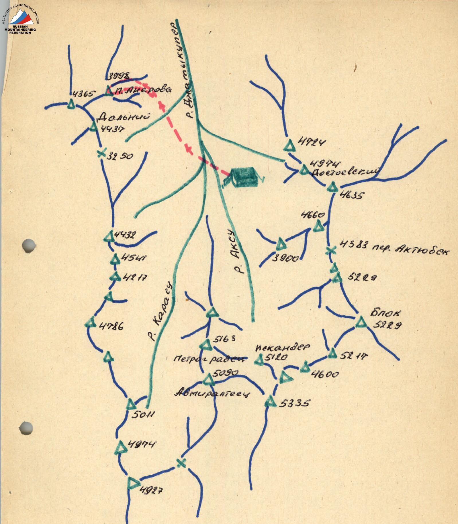
MAP-SCHEME of the Ak-Su area, Turkestan Range, scale 1:100000. Group's route map.
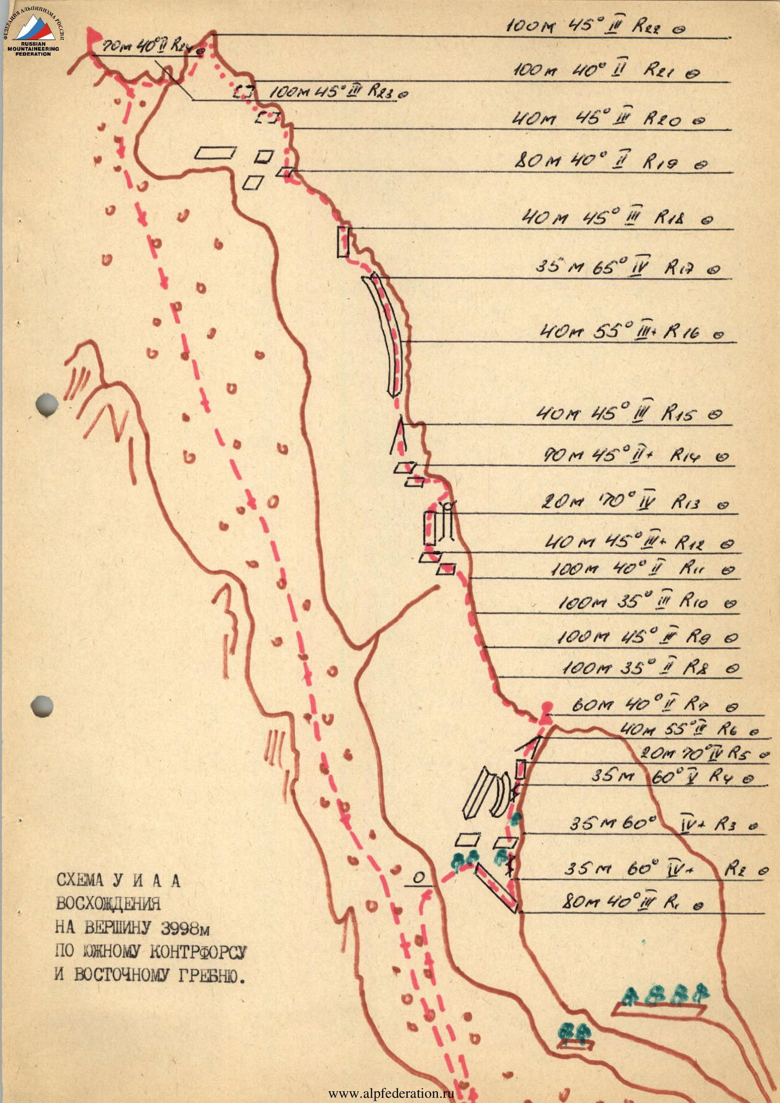
ASCENT SCHEME TO THE 3998 m PEAK ALONG THE SOUTHERN COUNTERFORT AND EASTERN RIDGE. Table of main characteristics of the ascent route.
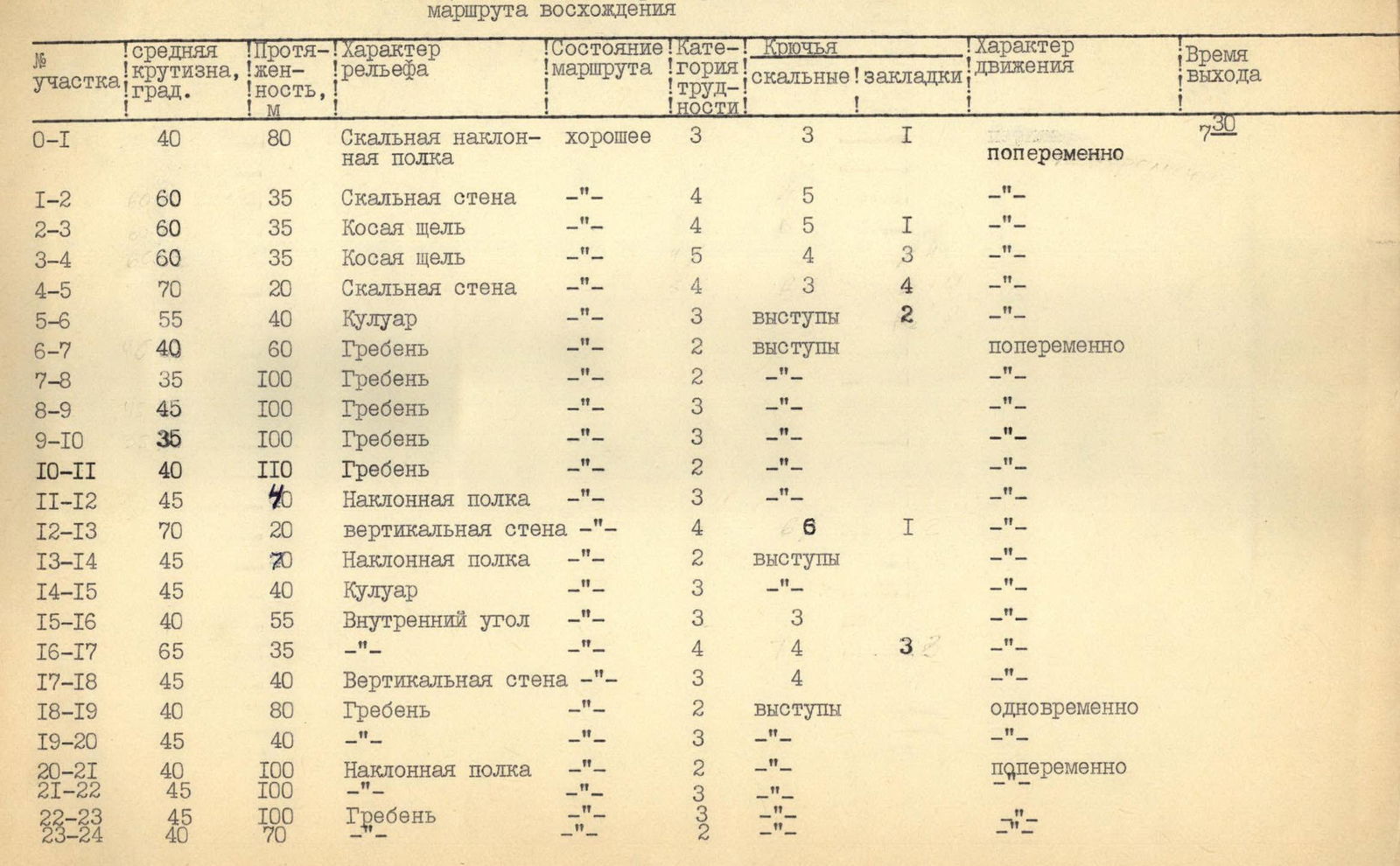
Sections
R0–R1 Along the inclined shelf overgrown with juniper, traverse right: first up, then down behind the counterfort.
R1–R2 Up the wall to an inclined inner corner in the lower part, overgrown with juniper.
R2–R3 Up the cleft to junipers 15 m and up to the right along the wall towards a shelf with juniper.
R3–R18 Up to the left along the cleft of the inner corner. Crux. The wall is monolithic with a large number of footholds and cracks for belay organization. There are options for movement:
- Levee along the inner corner (without a cleft);
- With further ascent into the couloir.
R4–R5 Up to the right along the shelf to the couloir; belay through ledges, pitons.
R5–R6 Up to the right along the couloir — exit to the ridge. Variable movement.
R6–R7 Up, on the slab, on the right — a control cairn.
R7–R11 Movement along the ridge 400 m. Variable movement. In some places — simultaneous.
R11–R12 Left along inclined shelves towards a chimney with a plug at the top.
R12–R13 Bypassing the chimney with a plug on the wall to the left, exit to the ridge.
R18–R17 Movement along inclined shelves, couloir, inner corner — up along the ridge. Climbing is несложное. Belay is variable.
R17–R20 Movement along the ridge, overcoming несложные walls, shelves. Simultaneous belay.
R20–R22 Deviation from the ridge along shelves — exit to the subpeak. Variable belay.
R22–R24 Descent to the saddle, then along несложные rocks — exit to the summit. Simultaneous movement. Descent from the summit to the saddle. Then down the scree — to the base camp.
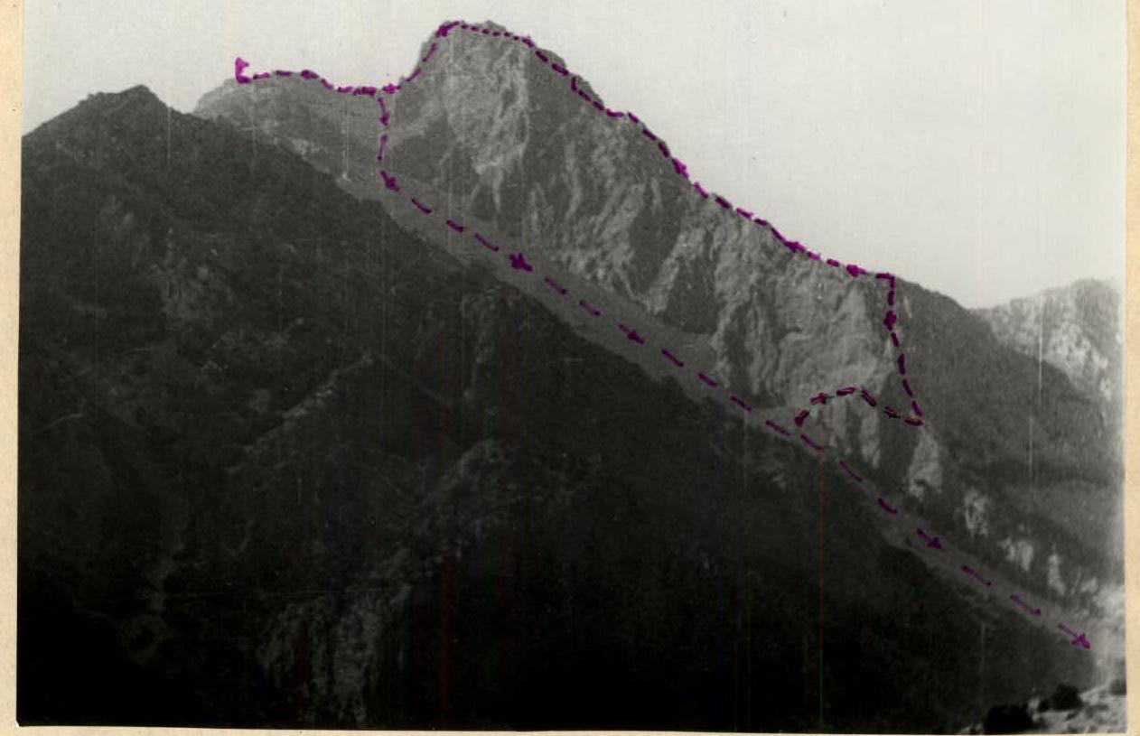
General view of the peak