Ascent Log
Completed in the 1982 Leningrad City Alpinism Championship
- Ascent class: technical
- Ascent area: Pamir range, Turkestan range, AkSu valley
- Peak, its height, ascent route: Petrogradets 5163 m via the center of the "south-east wall"
- Proposed difficulty category: 5B cat. diff. (rocky)
- Route characteristics: height difference 4200–5163 m (963 m), length of sections with 5–6 difficulty category 490 m, sections with 5th cat. diff. — 395 m, sections with 6th cat. diff. — 95 m, average steepness 72°
- Pitons driven: for insurance, rock — 122, ice — 0, bolt — 0, chocks — 39; for creating artificial anchors, rock — 29, ice — 0, bolt — 0
- Number of climbing hours: 37 over 4 days
- Number of overnight stays and their characteristics: 3 overnight stays — shared (2 short lying, 1 — sitting)
- Surname, name, patronymic of the leader, participants, and their qualification
| Leader | Parvin Vladimir Sergeevich | CMS |
|---|---|---|
| Members | Tulaev Ivan Ivanovich | CMS |
| Antipin Vitaly Mikhailovich | CMS | |
| Kuznetsov Sergey Nikolaevich | CMS | |
| Gatapov Sergey Borisovich | 1st sports rank |
- Team coach: Trofimenko L. A. | HMS
- Dates of departure and return: July 5–10, 1982 July 5 — approach, July 9–10 — descent and return to base camp
- Team's ranking:
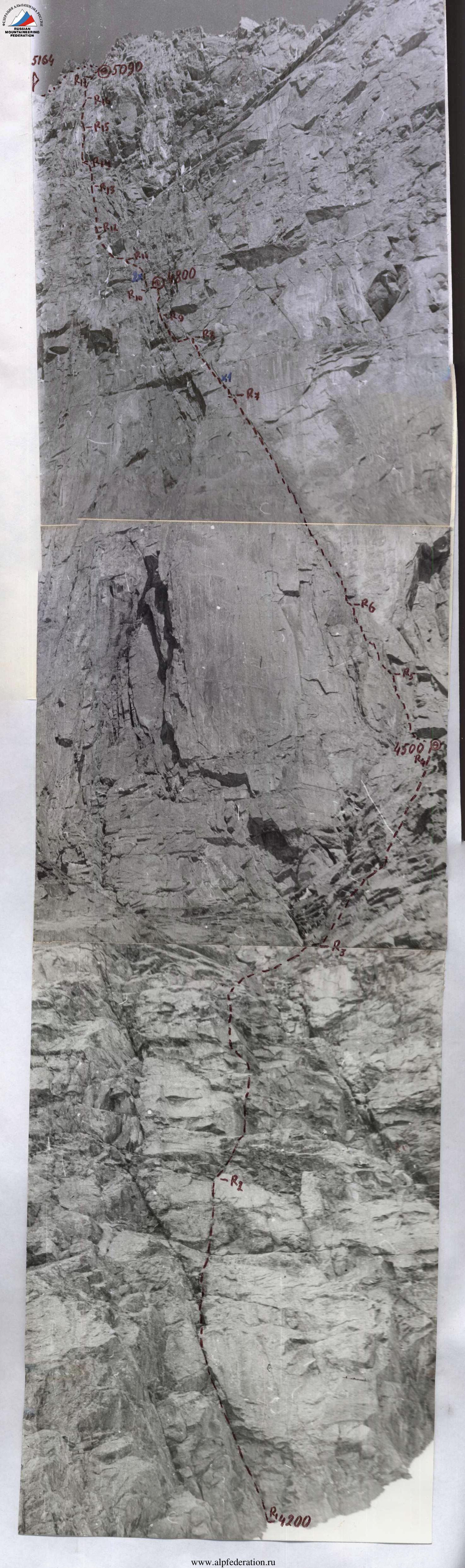
Table of main characteristics of the ascent route. Ascent route: Petrogradets peak 5163 m via the center of the south-east wall
- Route length: 1085 m
- Route height difference: 963 m
- Length of most difficult sections: 285 m
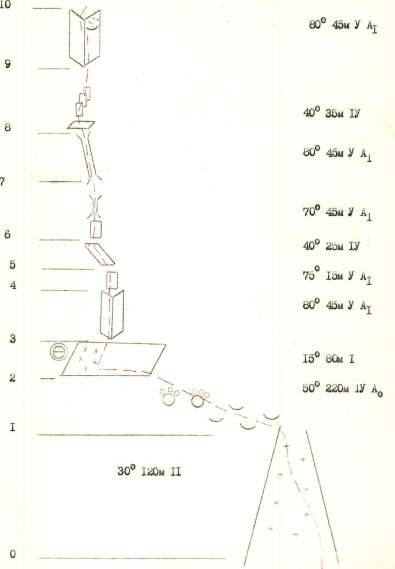
Route steepness
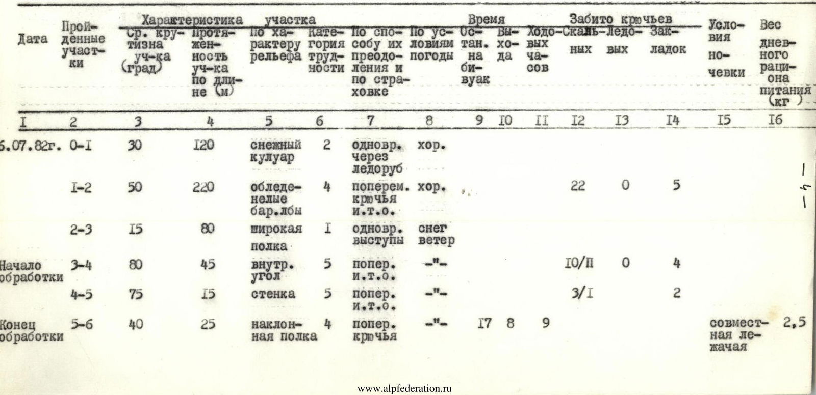
| Date | Section | Avg. section steepness (°) | Section length (m) | Terrain characteristics | Cat. diff. | Method of overcoming and insurance | Weather conditions | Biwak (stops) | Departure | Climbing hours | Pitons driven (rock) | Pitons driven (ice) | Chocks | Overnight stay conditions | Daily ration weight (kg) |
|---|---|---|---|---|---|---|---|---|---|---|---|---|---|---|---|
| July 6, 1982 | R0–R1 | 30 | 120 | snowy couloir | 2 | simultaneous via ice axe | good | 1 | |||||||
| R1–R2 | 50 | 220 | icy "baranyi lby" | 4 | alternating, pitons, artificial anchors | good | 22 | 0 | 5 | 1 | |||||
| R2–R3 | 15 | 80 | wide shelf | 1 | simultaneous, ledges | snow, wind | |||||||||
| Start of processing | |||||||||||||||
| R3–R4 | 80 | 45 | inner corner | 5 | alternating, artificial anchors | 10 | 0 | 4 | |||||||
| R4–R5 | 75 | 15 | wall | 5 | alternating, artificial anchors | 3 | 0 | 2 | |||||||
| R5–R6 | 40 | 25 | inclined shelf | 4 | alternating, pitons | 17:00 | 8 | 9 | shared lying | 2.5 | |||||
| July 7, 1982 | R6–R7 | 70 | 45 | walls, chimneys, inner corners | 5 | alternating, artificial anchors | good | 4 | 0 | 6 | |||||
| R7–R8 | 80 | 45 | wide chimney | 5 | alternating, pitons | 9 | 0 | 0 | |||||||
| R8–R9 | 40 | 35 | destroyed walls | 4 | alternating, pitons, ledges | 6 | |||||||||
| R9–R10 | 80 | 45 | inner corner | 5 | alternating, pitons, artificial anchors | 12 | |||||||||
| R10–R11 | 70 | 45 | destroyed walls, chimney | 5 | alternating, pitons | snow, wind | 5 | 2 | |||||||
| R11–R12 | 50 | 35 | system of cracks | 4 | alternating, pitons | 17:00 | 10 | 7 | 3 | shared lying | 2.5 | ||||
| July 8, 1982 | R12–R13 | 80 | 50 | monolithic wall | 5 | good | 6 | 2 | |||||||
| R13–R14 | 90 | 30 | narrow chimney | 6 | 7 | ||||||||||
| R14–R15 | 75 | 60 | rock blocks, monolith | 5 | 8 | 2 | |||||||||
| R15–R16 | 45 | 20 | inclined blocks, 5 m chimney | 4 | 3 | 1 | shared sitting | ||||||||
| Processing | |||||||||||||||
| R16–R17 | 85 | 20 | wall, monolith | 6 | alternating, pitons, artificial anchors | wind, cold | 17:00 | 8 | 9 | 5 | 3 | 2.5 | |||
| July 9, 1982 | R17–R18 | 95 | 20 | wide inner corner with overhangs | 6 | good | 6 | ||||||||
| R18–R19 | 80 | 25 | system of walls and cracks, balcony | 6 | 9 | 10 | |||||||||
| R19–R20 | 60 | 30 | inclined chimney | 5 | alternating, pitons | snow, wind, cold | 4 | ||||||||
| R20–R21 | 75 | 25 | inner corner with crack | 5 | 7 | 2 | |||||||||
| R21–R22 | 60 | 25 | destroyed walls with blocks | 4 | 2 | ||||||||||
| R22–R23 | 30 | 25 | snowy ridge | 2 | simultaneous, 20 ice axes | 8 | 12 | single | 2.5 |
Brief explanation of the technical characteristics table and recommendations for subsequent climbers.
R0–R1
The beginning of the route — a clearly defined wide snow-ice couloir leading to the right side of the shelf at the base of the wall. In the late hours (active melting time), the couloir is shot with small stones and icicles, so both descent and ascent are recommended in the first half of the day.
R1–R2
Through destroyed rocks and "barany lby" — exit left along the way to a wide shelf. Climbing is complicated by ice formation, cracks are mostly filled with snow or covered with ice.
R2–R3
A wide inclined scree shelf is traversed from right to left under the base of a not clearly defined counterfort in the center of the south-east wall, along which the main part of the route passes. In the left part of the shelf — a convenient overnight stay. Control cairn.
R3–R4
A steep inner corner with a limited number of holds. Climbing is difficult with the use of artificial anchors. The weather deteriorates, the group stays on a bivouac, a pair starts processing.
R4–R5
A monolithic rock wall is passed from left to right, there are few holds, many convenient places for driving pitons.
R5–R6
An inclined narrow shelf is traversed from right to left under the base of the wall leading to a system of chimneys and inner corners. (The weather finally deteriorates, end of processing).
R6–R7
The wall is overcome head-on, chimneys and inner corners are filled with ice and icicles. Climbing is difficult with the use of artificial anchors.
R7–R8
A wide steep chimney with a limited number of holds and places for driving pitons leads to a small shelf — a convenient place for insurance.
R8–R9
Through a system of destroyed walls, to the right — exit to the edge of the counterfort. Pay attention to the presence of loose rocks!
R9–R10
Enter a steep inner corner with smoothed walls. In the upper part of the corner — an overhanging section with ice, bypassed along the wall on the left.
R10–R11
Through destroyed rocks with small walls — movement towards a large overhanging block, which is bypassed on the right.
R11–R12
Through a system of small shelves and walls — traverse to the right onto a convenient shelf for an overnight stay. The weather deteriorates, the group stays on a bivouac.
R12–R13
A steep monolithic wall is overcome head-on. Many small holds and convenient places for chocks and pitons. A convenient place for organizing insurance — only after 50 m on the right wall of the chimney. Climbing is difficult, mainly on friction.
R13–R14
A vertical narrow chimney with smoothed walls is overcome by very difficult climbing in a stem.
R14–R15
Through large monolithic rock blocks — exit under an overhang, which is bypassed on the right. Many cracks for chocks, holds, and places for driving pitons.
R15–R16
Along inclined blocks up and to the right — to a 5 m chimney filled with ice. From the chimney — traverse to the right in the direction of a clearly defined detached stone on the edge. Behind the edge between the rock blocks — a convenient closed shelf for a sitting overnight stay for five people. Bivouac, control cairn.
R16–R17
The beginning of the key section of the route. In the evening, a steep monolithic wall with a wide crack is processed. Climbing is extremely difficult, limited number of holds and places for pitons. Movement is first head-on along the wall, then along the crack — to a small shelf (for one) under an overhang.
R17–R18
Along a wide inner corner with an overhang to the right of a hanging black block. Climbing is mainly in étriers with artificial anchors, first along the central crack of the right wall, after the overhang — transition through the edge to the left wall, where friction climbing is required with a limited number of holds and places for pitons.
R18–R19
Through a system of small shelves, walls, and narrow cracks convenient for chocks — exit left upwards onto a good horizontal shelf — a convenient place for organizing insurance. End of the key section.
R19–R20
Along an inclined chimney starting to the right of the shelf, with a small overhang in the upper part — exit onto a large scree-covered shelf at the base of a wide couloir leading to the pre-summit ridge. Climbing is complicated by wet rocks and deteriorating weather.
R20–R21
Along an inner corner with a crack filled with snow — exit onto a wide shelf before the ridge. Rocks are destroyed, covered with snow, one must be extremely cautious!
R21–R22
Bypass a small wall — traverse it in the lower part to the left and through destroyed blocks — exit onto the ridge.
R22–R23
Along a gentle snowy ridge 25 m to the left — to the summit tower. Snow is deep, to the right — steep cliffs to the north. Pay attention to avalanche danger!
Descent
- First (200 m) — along a steep snowy ridge with cornices in the direction of the eastern col between Petrogradets and Iskander (5120 m) peaks.
- Then 150 m rappels — along a steep snow-ice couloir to ice falls.
- Before the falls — traverse to the left along destroyed rocks to the eastern ridge.
- Then 120 m (3 sports) — into a steep snowy couloir, under the col that bends to the right.
- Along the couloir simultaneously 250 m — to "barany lby" and rock falls.
- Then 80 m to the right — along scree shelves and gentle rocks to the snowy couloir at the beginning of the route.
The total descent takes 4–5 hours.

Photo of the route profile taken from the summit of Iskander 5120 m. Route scheme in UIAA conventional symbols.
Route scheme in UIAA conventional symbols (continued)

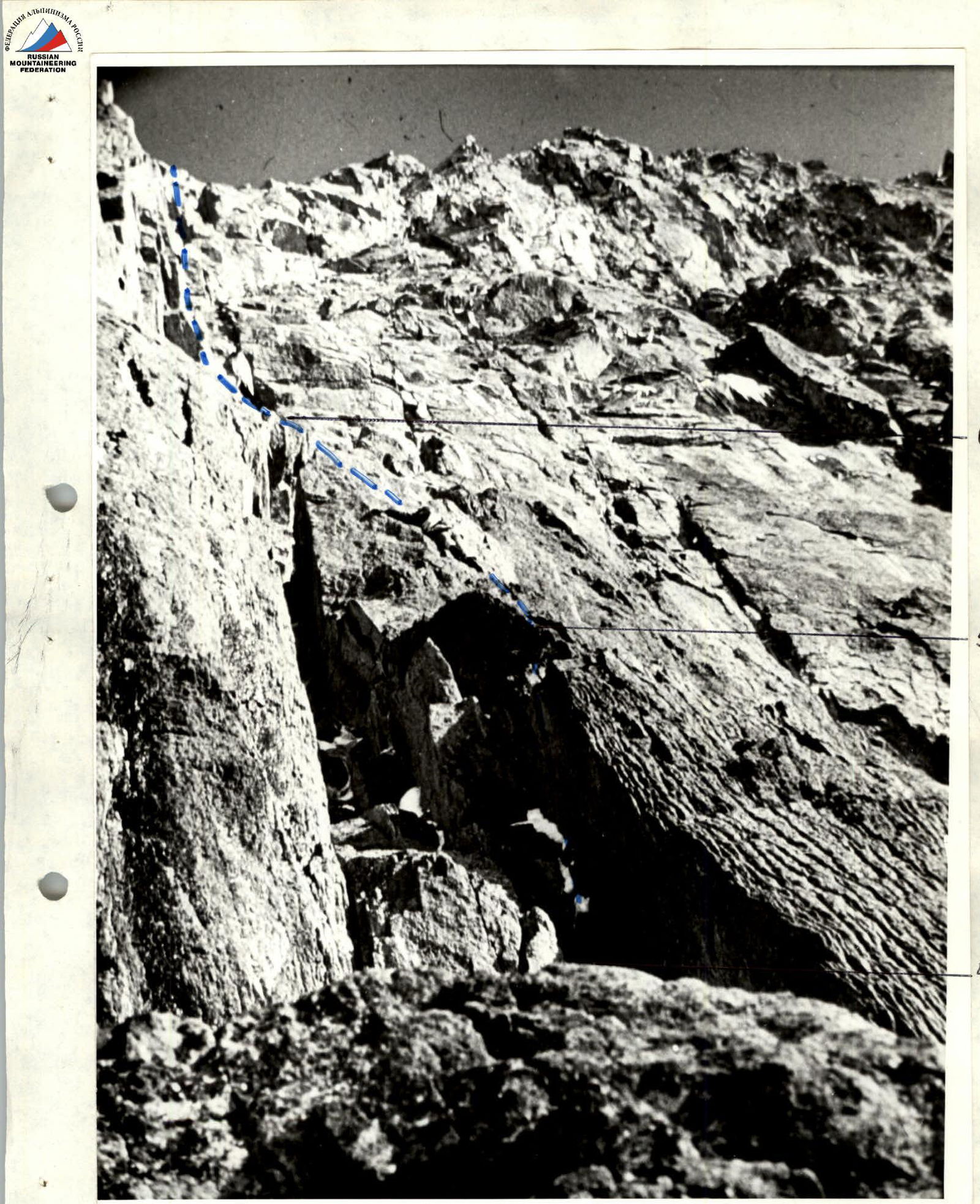
Photo of sections R4–R6
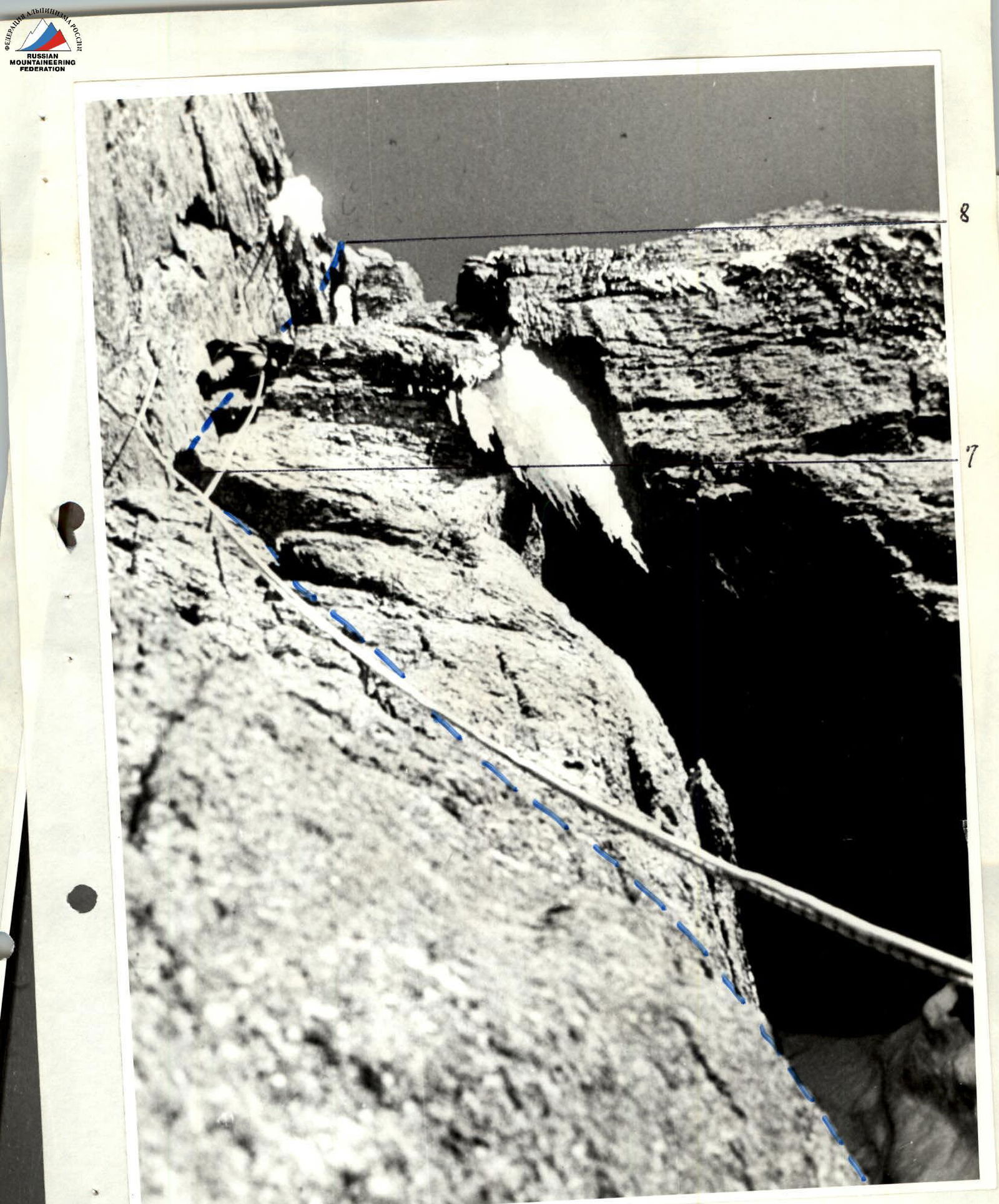
Photo of sections R7–R8

Key section of the route, sections R16–R18.