Ascent Passport
I. Ascent class: Technical 2. Ascent area: Pamir, Turkestan Range, Ak-Su gorge 3. Peak, its height, ascent route: Iskander, 5140 m, via the Northwest ridge 4. Proposed complexity category: 5B category, rock 5. Route characteristics: height difference 4300–5140 m, 840 m; length of sections of 5–6 cat. sl. 420 m (V — 305 m, VI — 115 m); average steepness 62° 6. Pitons driven: for belaying: * Chocks — 68 * Rock — 171 * Ice — 9 * Bolts — 0 for creating anchor points: * Rock — 88 * Chocks — 21 * Ice — 3 * Bolts — 0 7. Number of climbing hours: 30 h, 4 days 8. Number of bivouacs and their characteristics: 3 bivouacs, shared, lying down 9. Surname, name, patronymic of the leader, participants, and their qualification: participants:
- Parshin Vladimir Sergeyevich, CMS
- Tulaev Ivan Ivanovich, CMS, 10946 A-9, 44.44 sb semi-co 9-42
- Team coach: Troshchinenko Leonid Andreyevich, MS
- Dates of departure and return: Departure on July 15, 1982, return to base camp on July 20, 1982
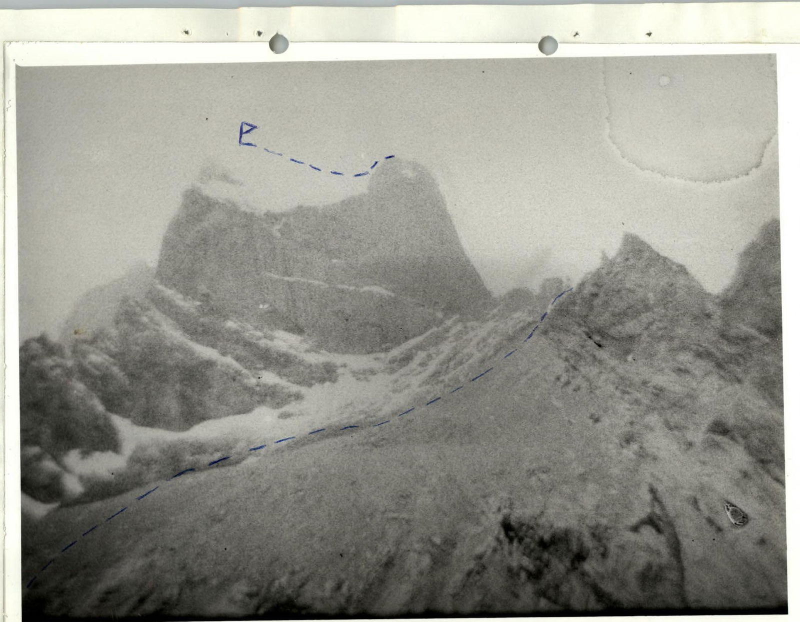
Photo of the general view of the peak from the Ak-Su gorge.
Table of the main characteristics of the ascent route
| Date | Designation | Average steepness (°) | Length (m) | Terrain characteristics | Difficulty | Condition | Weather conditions | Rock | Ice | Chocks | Bivouac conditions |
|---|---|---|---|---|---|---|---|---|---|---|---|
| 16.07.1982 9:00 | R0–R1 | 40 | 80 | Destroyed snow-covered rocks, destroyed | IV | Snow-covered, destroyed | good | 4 | 0 | ||
| R1–R2 | 70 | 30 | Inner corner with ice | V | Icy | good | 12/VIII | 0 | 2 | ||
| R2–R3 | 80 | 40 | Wall with a tapering crack (pendulum) 5 m to the right | VI | Monolithic, smooth | -" | 18/X | 0 | 4/V | ||
| R3–R4 | 65 | 40 | Crack | V | Snow, ice | -" | 8 | 0 | 2 | ||
| R4–R5 | 70 | 15 | Wall under an overhang | V | Flowstone | wind, cold | 6/IV | 0 | 3 | ||
| 17.07.1982 17:00 | R5–R6 | 50 | 25 | Inner corner chimney | IV | Snow | Snow | 6/II | 0 | 1 | Shared, lying down |
| 17.07.1982 10:00 | R6–R7 | 70 | 50 | 10 m crack wall | V | Ice, monolithic | good | 18/II | 0 | 3/III | |
| R7–R8 | 70 | 30 | Wall with a vertical crack | V | Monolithic | -" | 12/X | 0 | 5 | ||
| R8–R9 | 80 | 35 | Wall with 2 parallel cracks | VI | Monolithic | wind, sleet | 7/II | 0 | 7/V | ||
| R9–R10 | 80 | 10 | Crack | VI | Ice | snow | 3/V | 0 | 5/III | ||
| 18.07.1982 20:00 | R10–R11 | 60 | 30 | Chimney | V | Ice, snow | snow | 7 | 0 | 0 | Shared, lying down |
| 18.07.1982 9:00 | R11–R12 | 85 | 50 | Wall with a crack under an overhang 1.5 m | V | Monolithic | good | 21/XIV | 0 | 14 | |
| R12–R13 | 70 | 15 | Chimney | V | Ice | -" | 5/III | 0 | 4 | ||
| R13–R14 | 70 | 15 | Wall under a cornice | VI | Monolithic | -" | 10/III | 0 | 5/V | ||
| R14–R15 | 80 | 15 | Diagonal crack | VI | Ice | -" | 5/VI | 9/III | 6 | ||
| 19.07.1982 20:00 | R15–R16 | 60 | 80 | Destroyed rocks | IV | Snow | snow | 9 | 0 | 3 | Shared, lying down |
| 19.07.1982 10:00 | R16–R17 | 10 | 30 | Horizontal crack | V | Snow | good | 4 | 0 | 2 | |
| R17–R18 | 70 | 10 | Chimney | V | Ice | -" | 5 | 0 | 1 | ||
| R18–R19 | 35 | 35 | Destroyed rocks | IV | Snow | -" | 5/I | 0 | 1 | ||
| R19–R20 | 20 | 40 | Ledges | IV | Snow, ice | -" | 2 | 0 | 0 | ||
| R20–R21 | 85 | 10 | Inner corner wall | V | Snow | 8/III | 0 | 0 | |||
| West summit | R21–R22 | 30 | 40 | Destroyed rocks | III | Snow | -" | simultaneous | |||
| Descent down 19.07.1982 17:00 | R22–R23 | 20 | 300 | Ridge | III | Destroyed | -" | simultaneous | |||
| R23–R24 | 30 | 300 | Slope | II | Snow | -" | simultaneous | ||||
| Main summit | |||||||||||
| Total for 30 climbing hours | 1335 m | 171/88 | 9/3 | 68/21 | |||||||
| Of which wall part | 735 m |
Brief explanation of the table of technical characteristics and recommendations for subsequent climbers.
Sect. R0–R1. From the bivouac under the base of the Northwest ridge along heavily destroyed and snow-covered rocks slightly to the right of the black overhang. Sect. R1–R2. The inner corner is climbed first along its left part, and then along the central crack filled with ice, using an ice axe or ax and cutting steps. Sect. R2–R3. The wall with a crack tapering at the top requires a 5 m pendulum to the right to a convenient crack. The rocks are monolithic, smooth, and very difficult to climb using anchor points. Sect. R3–R4. The crack filled with snow and ice leads to a wall under an overhang. Sect. R4–R5. Climbing the wall is complicated by flowstone, requiring the use of anchor points. Sect. R5–R6. To the right of the overhang, a gentle inner corner turning into a chimney leads to a good ledge where a shared bivouac can be set up for a group of no more than 4 people. Control cairn. Sect. R6–R7. The icy monolithic wall, despite its relatively gentle slope, is climbed with great difficulty, first along a 10 m crack, and then using anchor points. Sect. R7–R8. A very monolithic wall with a vertical crack convenient for driving pitons. Limited handholds, difficult climbing. Sect. R8–R9. The wall with two parallel cracks is convenient for sector chocks. The rock is smooth, with limited handholds. One of the most difficult sections of the route, climbed with extreme difficulty using anchor points. Sect. R9–R10. A 10 m vertical crack with limited handholds is climbed using ladders and leads to a small inclined ledge at the base of a chimney. Sect. R10–R11. The lower part of the icy chimney is filled with snow. At the top, a stemming move with ice axe steps leads to the left onto the ridge shoulder. A convenient place for a bivouac, practically the first one for the whole day's work. Control cairn. Sect. R11–R12. A monolithic steep wall with a crack leads under a 1.5 m overhang, which is bypassed to the right. The rock is smooth, with many cracks for driving pitons, possibly using anchor points. Sect. R12–R13. A steep, ice-filled chimney is overcome by stemming and cutting steps. Pitons can be driven conveniently on the left. Sect. R13–R14. A monolithic wall is climbed directly and leads under a 0.5 m cornice with a crack leading to a diagonal crack. Climbing is very difficult, requiring the use of anchor points. Sect. R14–R15. Up and to the left along a steep, ice-filled crack using ice pitons for anchor points. Climbing is extremely difficult, a key section of the route. At the top, the crack widens into a chimney; on the left, there are convenient cracks for driving pitons. Sect. R15–R16. Along destroyed, icy rocks up and to the right onto a snowy shoulder. Rockfall hazard! A convenient place for a bivouac. Sect. R16–R17. Traverse to the right along a horizontal crack on a sheer wall. The rocks are icy and snow-covered; extreme caution is required! Sect. R17–R18. A steep, ice-filled chimney with a plug is overcome by stemming, exiting onto its left wall and a large snow-covered ledge. Sect. R18–R19. Along gentle, destroyed rocks and snow — exit onto a wide ledge. Sect. R19–R20. Along a gentle system of snow-covered ledges with a height gain — exit under the base of an inner corner. Sect. R20–R21. Along a smooth, vertical inner corner under a 5 m wall, which is climbed with difficult climbing using anchor points. Sect. R21–R22. Along gentle, destroyed rocks and snow — exit onto the West summit. Simultaneous movement, control cairn. Sect. R22–R23. From the West summit, descend down to the east: first along a destroyed ridge, and then along snow onto the plateau between the summits. Sect. R23–R24. Along a snowy slope up onto the main summit. Caution: the snow, although deep, lies on fairly steep ice (30°); there is a risk of slipping or a "snowboard" slide.
Descent from the summit:
- 20 m sport climbing towards the peak Petrogradets 5163 m;
- then along the dissected SW ridge with many "jandarmes" (3 rappels of 20 m);
- 40 m before the saddle — to the left along the route, 4 rappels of 30 m towards the couloir leading from the saddle to the glacier.
In the lower part of the couloir, gathering is done by bypassing to the right along "ram's foreheads".
The total descent to the glacier takes 6–8 hours.
Photo of the profile of the wall part of the route from the East
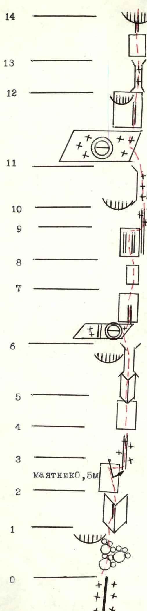
Route diagram in UIAA conventional symbols
- cornice 0.5 m
- 70° 15 m V1 anchor points
- 70° 15 m V
- 85° 50 m V anchor points
- 60° 30 m V
- 80° 10 m V1 anchor points
- 80° 35 m V1 anchor points
- 70° 30 m V anchor points
- 70° 50 m V anchor points
- 50° 25 m IV anchor points
- 70° 15 m V anchor points
- 65° 40 m V
- 80° 40 m V1 anchor points
- 70° 30 m V anchor points
- 40° 80 m IV

Route diagram in UIAA conventional symbols (continued)
- P 5140 m
- snowy ascent to the summit 30° 300 m III
- descent onto the plateau 20° 300 m III
- West summit
- 50° 40 m IV anchor points
- 85° 10 m V anchor points
- 20° 40 m IV
- 35° 15 m V anchor points
- 70° 10 m V
- 30° 10 m V
- 60° 80 m IV
- 80° 15 m V1 anchor points
- cornice 0.5 m
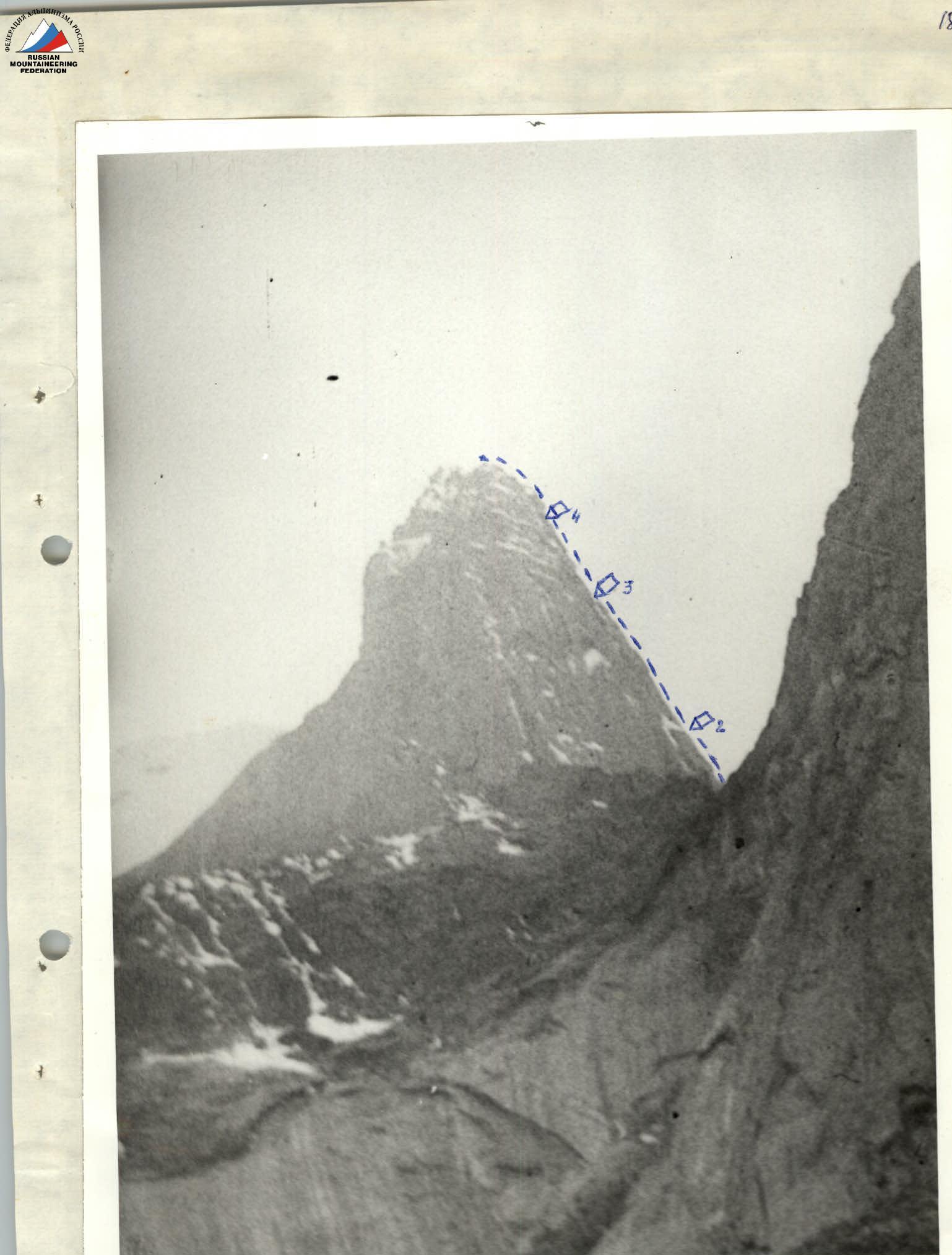
- Photo of the route profile from the East with bivouacs