ASCENT DOCUMENT
I. Technical category. 2. Pamir-Alay, Turkestan Ridge, Ak-su gorge. 3. Peak 5000 (Severny Iskander) via the northwestern edge. 4. Proposed category: 6B, rock, first ascent. 5. Height difference — 1000 m, length — 1330 m
Height difference of the wall section — 750 m, length of the wall section — 830 m, average steepness of the wall section — 65°, length of sections of 5th category — 255 m, length of sections of 6th category — 320 m.
-
Pitons hammered: rock: 90/16 chocks: 80/4 bolts: 21 ice screws: 8
-
Number of climbing hours (excluding approaches): a) to the summit — 44 hours b) on descent — 12 hours
-
Number of nights: a) on ascent — 5 b) on descent — 1
Nights spent in two locations, in tents.
- Team leader: Vasiliev S.I. — Candidate Master of Sports
Team members: Ginzburg S.A. — Candidate Master of Sports Gladkov S.Yu. — Candidate Master of Sports Makhnovetsky A.B. — Candidate Master of Sports Shaginyan I.E. — Master of Sports of the USSR Tsybanov V.V. — 1st class
Coach: Kozlov Yu.E. — Master of Sports of the USSR
- Departure to the route: July 4, 1985 Summit: July 10, 1985 Return: July 11, 1985
- The numerator indicates the total number of pitons, the denominator indicates the number used for artificial climbing.
Fig. 1. General view of the summit (photo 1). Taken on July 1, 1985 at 11:00 from the summit of Peak 4432, distance — 7 km, Jupiter-37A lens (F = 135).
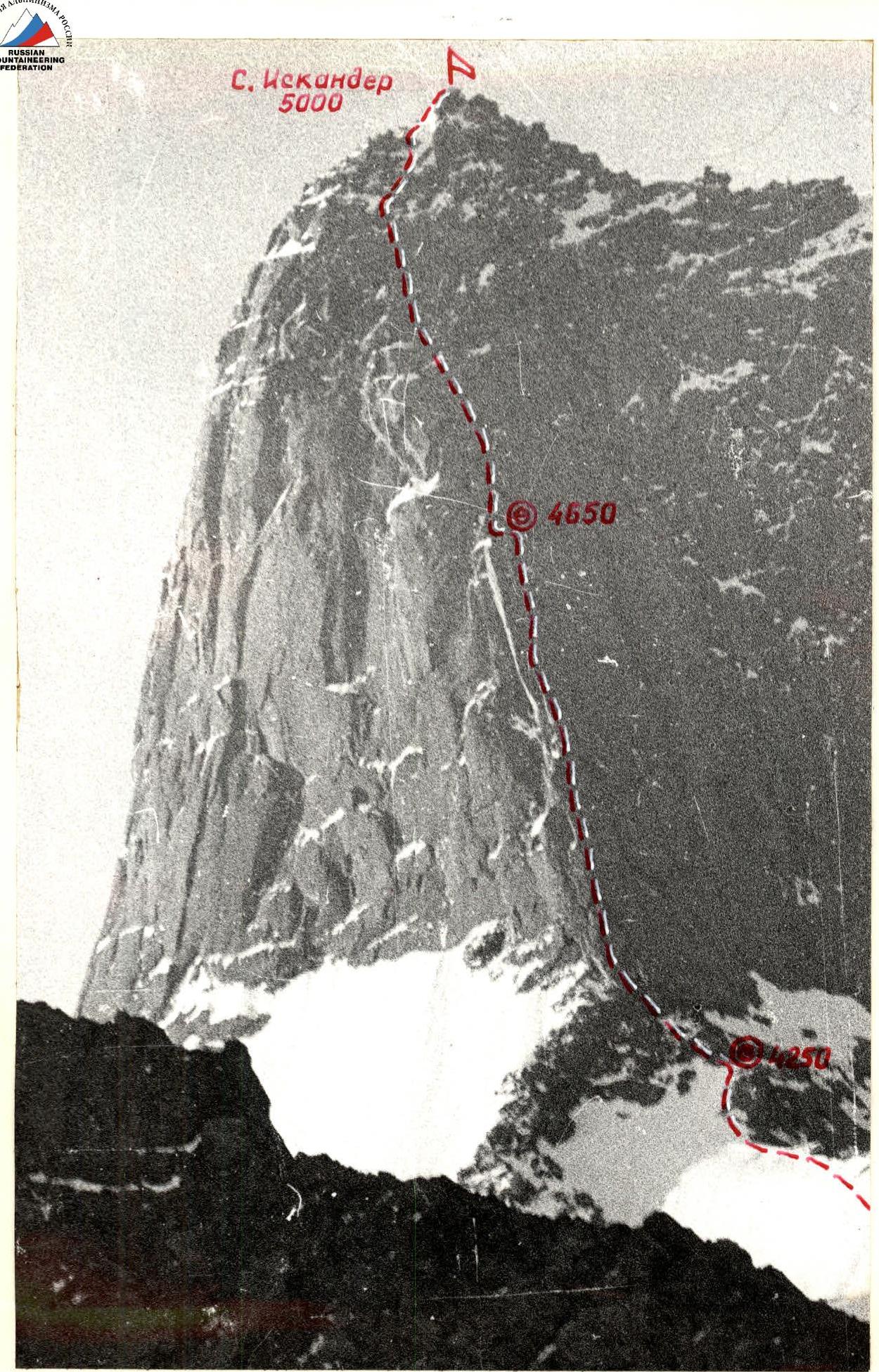
Fig. 2. Route profile from the right (photo 2). Taken on July 27, 1985 at 14:00 from the summit of Peak 4786, distance — 8 km, G-44-2 lens (F = 58).
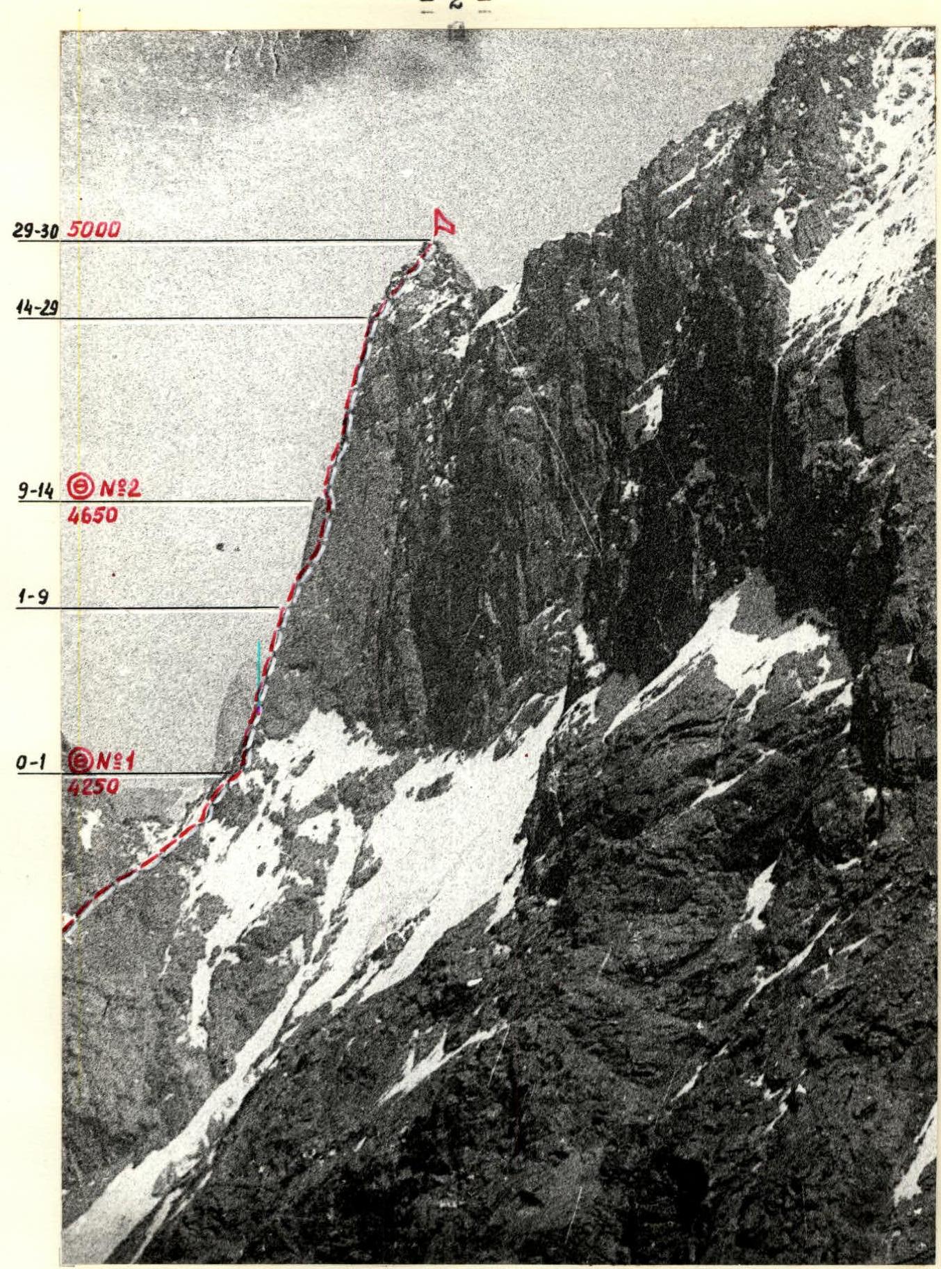
Fig. 3. Route profile from the left (photo 3). Taken on July 1, 1985 at 12:00 from the summit of Maly Iskander (4520 m), distance — 1 km, I-26M lens (F=52).

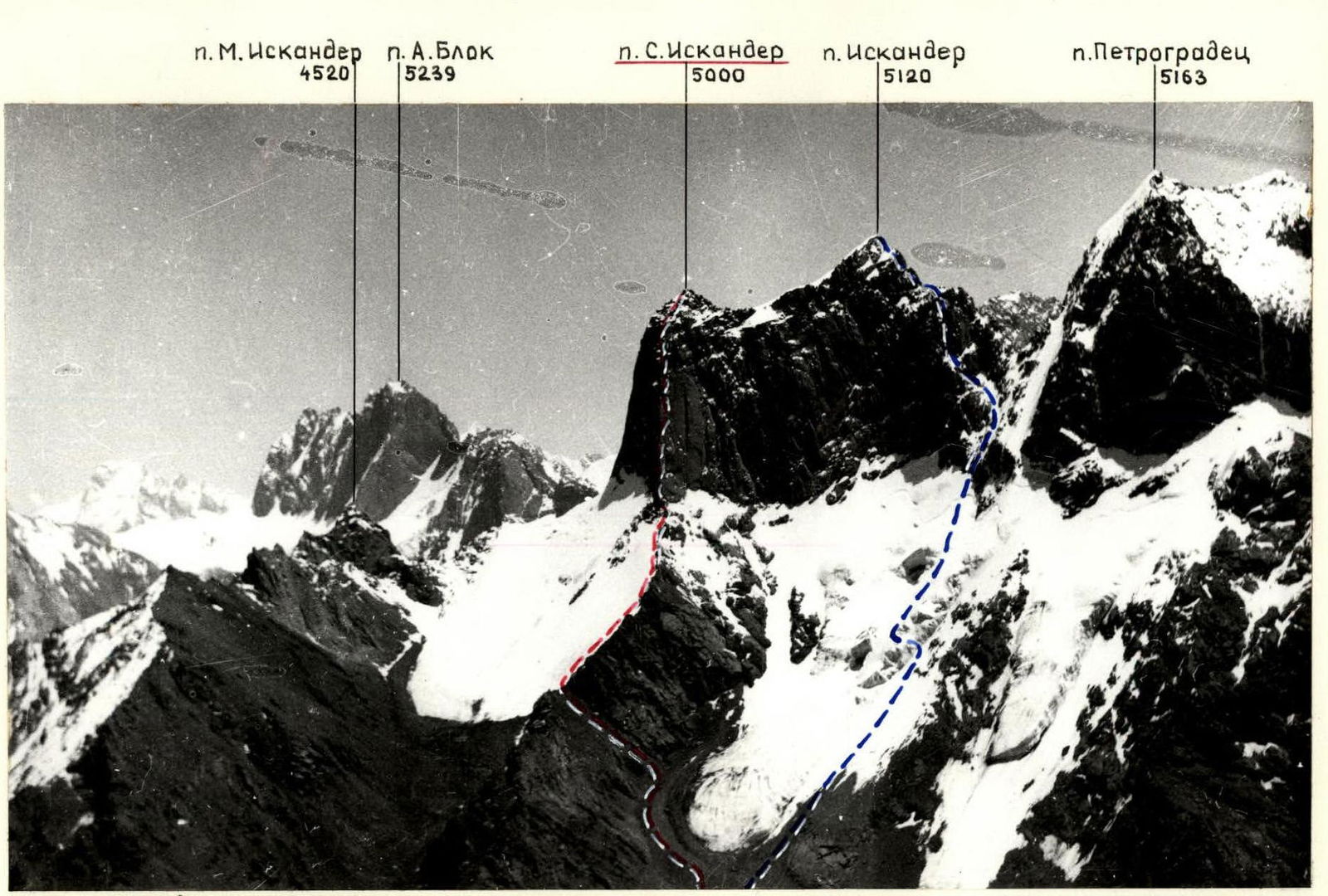

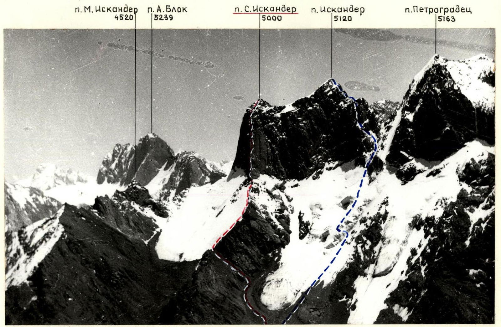 Fig. 6. Panorama of the area (photo 4). Taken on July 16, 1983 at 11:00 from the summit of Peak 4541, distance — 7 km, T-43 lens (F = 75).
Tactical Actions of the Team
July 4. At 14:00, the team left the base camp of the USB "Alay" and at 20:00 ascended to the saddle of the northwestern Iskander massif to the tents set up during the reconnaissance. July 5. Leaving the bivouac on the saddle at 8:00, the group approached the wall by 11:00. Then, the rope team Ginzburg — Makhnovetsky went down to the saddle for the remaining gear, while the rope team Vasiliev — Gladkov conducted additional reconnaissance. (Upon departure, the group was instructed to conduct additional reconnaissance on July 5 regarding the feasibility of passing the first half of the wall through the left large internal angle.) As a result of this reconnaissance, the group decided against moving through the internal angle for the following reasons: movement through the angle was objectively more dangerous than moving along the wall, the angle was practically never sunlit and working in it was very cold, and the right side of the internal angle overhung, making the exit from the angle to the ledge potentially very difficult. It was decided to ascend directly along the edge and the wall to the right of it, where a system of cracks and internal angles leading to the ledge was visible.
At 16:00, the rope team Tsybanov — Makhnovetsky began processing the wall, and by 22:00, they had covered the first 250 m of the wall (sections R2–R8). The first climber worked on a double rope with a textile shock absorber. The belay rope was additionally secured at 1–2 points, significantly enhancing the safety of movement along it and facilitating ascending with jumar.
July 6. According to the tactical plan, the start of route processing was planned for 8–9 hours. However, it became clear that due to the northern exposure of the route, work before 11–12 hours was ineffective. Therefore, it was decided to make greater use of the favorable evening time for climbing and work until dark.
At 12:00, the rope team Ginzburg — Gladkov left the bivouac and, having passed the processed part of the wall, began further processing. Simultaneously, the rope team Vasiliev — Tsybanov carried out the hauling of loads along the fixed ropes.
During the day, a corrective radio communication session was held with the team coach, Kozlov Yu.E., who was observing the team's actions from platforms under the glacier. Recommendations were also received regarding the ascent of the upper part of the wall. At 17:00, when the leading rope team reported that there were no more than one and a half ropes to the ledge and that there were significant chances of reaching it, the rope team Makhnovetsky — Tsybanov hauled all necessary supplies for the night there.
July 7.
- The entire camp was relocated to the ledge, and the ropes were removed from the lower part of the wall. The rope team Gladkov — Ginzburg processed 60 m of the wall above the ledge (sections R14–R18).
- As anticipated, the key section of the route began above the ledge.
- The rocks were steep with overhangs, covered with rime ice in the morning, and water flowed over them after 18:00.
- Internal angles and cracks were filled with ice.
- Working before 12:00 was very cold.
July 8.
- At 11:00, the rope team Ginzburg — Makhnovetsky started processing the route.
- By 22:00, 140 m of the wall had been covered (sections R18–R24) along the left, more dissected part, as recommended by the coach.
- Further, 2–3 more complex rope lengths were visible, after which the path simplified.
- During the day, there was radio communication with the coach, who approved the team's actions in choosing the path.
- The leading rope team and the camp on the ledge had radio communication via "Vitalka".
July 9.
- By this day, according to the initial schedule, it was planned to process the complex part of the wall and then, leaving the bivouac with the entire group, ascend to the summit.
- However, due to the additional reconnaissance on July 5, as prescribed upon departure, about 80 m of the complex wall section remained unprocessed.
- Therefore, for safety reasons (to prevent the group from being under the working leading rope team), it was decided to dedicate this day to processing, and to make the ascent the following day.
At 11:00, the rope team Gladkov — Tsybanov left the bivouac, and by 19:00, the entire path to the summit was processed. July 10. At 9:00, the group left the bivouac and, moving along the fixed ropes in the rope teams Vasiliev — Gladkov, Shaginyan — Ginzburg, Makhnovetsky — Tsybanov, reached the summit by 12:00. At 15:00, the group descended to the bivouac on the ledge, and at 22:00 — to the platforms under the wall, leaving the last 3 ropes unpulled. July 11. The rope team Gladkov — Vasiliev removed the last 3 ropes from the wall. By 14:00, the group descended to the initial bivouac on the saddle and by 19:00 was back at the base camp of the USB "Alay".
Route Description by Sections
- R0–R1. Simple and moderately difficult rocky ridge. All gendarmes are bypassed on the left (in direction of travel) along a snow-ice slope of average steepness 40–45° or rocks.
- R1–R2. System of walls and ledges of moderate difficulty. Rocks are heavily destroyed, many loose stones.
- R2–R3. Narrow crack-chimney in a steep, smooth slab.
- R3–R4. Implicitly expressed wide internal angle consisting of a system of walls and ledges.
- R4–R5. Difficult internal angle with smooth walls.
- R5–R6. Very difficult smooth wall with limited holds. Passed to the right and upwards. Uses artificial climbing aids (ITOs) and ladders.
- R6–R7. Smooth wall to the right of a rocky overhang, weakly dissected. Passed using microrelief.
- R7–R8. Steep internal angle, rocks monolithic. Shouldered pitons and medium chocks go well.
- R8–R9. Wall connecting two ledges, on which, if necessary, a platform for a tent can be cleared.
- R9–R10. Very difficult monolithic smooth wall with poorly developed microrelief, passed by free climbing.
- R10–R11. Traverse to the right and upwards along a crack in a smooth wall using ITOs and ladders.
- R11–R12. Difficult monolithic wall, passed by free climbing. Behind the wall, a very complex exit into a wide internal angle-chimney.
- R12–R13. Large internal angle-chimney with an overhang in the upper part. When passing the overhang, ITOs and ladders are used.
- R13–R14. Internal angle with sections of ice and snow, leading to a ledge with a good two-tiered platform where two tents can be set up.
- Section R10–R14 can be passed along a 120–140 m crack in a smooth monolithic wall (80°), 5–6, to the left of the path chosen by the group.
- R14–R15. Traverse left 5 m along a snowy ledge. Further, a wall with a crack, passable by free climbing. Rocks are partially covered with rime ice.
- R15–R16. Steep, difficult monolithic wall with limited holds. Passed using ITOs and ladders.
- R16–R17. Plumb smooth ice-covered wall with very few holds to the left of an overhang. Passed using ITOs and ladders with the use of a bolt piton.
- R17–R18. Steep internal angle with smooth walls, filled with rime ice. Climbing is extremely difficult. Shouldered pitons and small chocks go well. Passed using ITOs and ladders.
- R18–R19. Very difficult, partially ice-covered wall. Passed by free climbing.
- R19–R20. Steep wall of tiered structure, abutting into an internal angle under an overhang.
- R20–R21. From under the overhang to the left through a small overhang — exit into a very difficult internal angle formed by a steep wall and a right plumb ledge about 1 m high. Until 12:00, the angle is filled with rime ice, after 16:00 water flows through it. Passed using ITOs and ladders. The internal angle abuts into an overhang.
- R21–R22. The overhang is passed in its right part with an exit into an internal angle, passable by free climbing. After 16:00, water flows through the angle.
- R22–R23. Steep wall leading to a snowy ledge.
- R23–R24. Very steep smooth wall with few holds and cracks for pitons. Extremely difficult climbing.
- R24–R25. Ice-covered internal angle with smooth walls, filled with rime ice. Passed using ice axes, ITOs, and ladders.
- R25–R26. Steep smooth slab to the right of an overhang, passed using skyhooks and ladders.
- R26–R27. Ice-covered chimney with a plug. Passed using ITOs and ladders.
- R27–R28. Extremely difficult smooth plumb wall to the right of an overhang. Passed using ITOs.
- R28–R29. Wall with a crack, passable by free climbing.
- R29–R30. System of snow-covered and ice-covered walls and ledges of medium and above medium difficulty, leading to the summit, which is an inclined slab.
Fig. 9. View of the route (photo 5) from the saddle of the northwestern ridge (4000 m). Taken on July 1, 1985 at 14:00, distance — 1 km, Jupiter-37A lens (F=135).
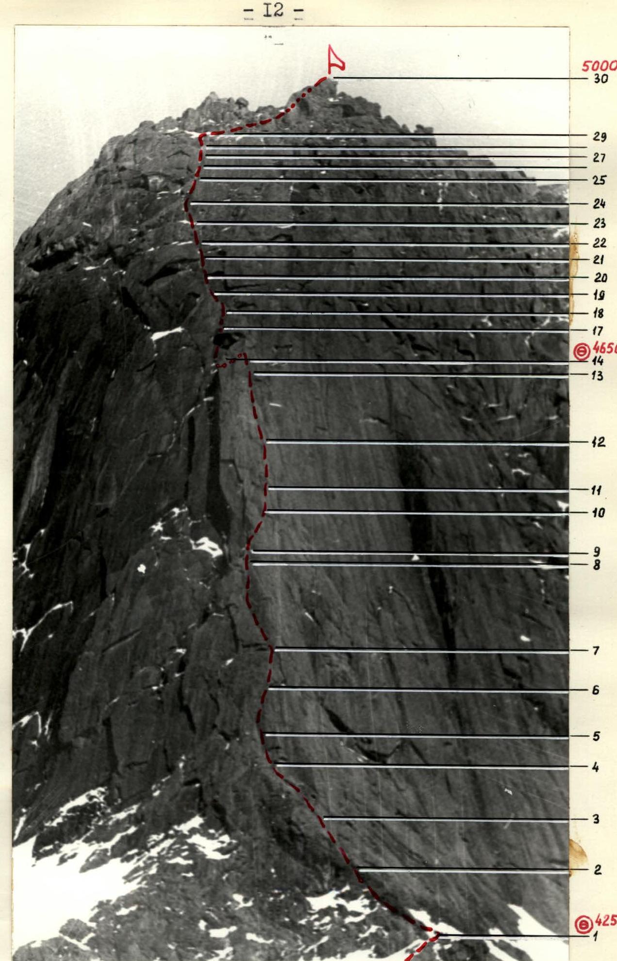
Fig. 8. UIAA scheme.
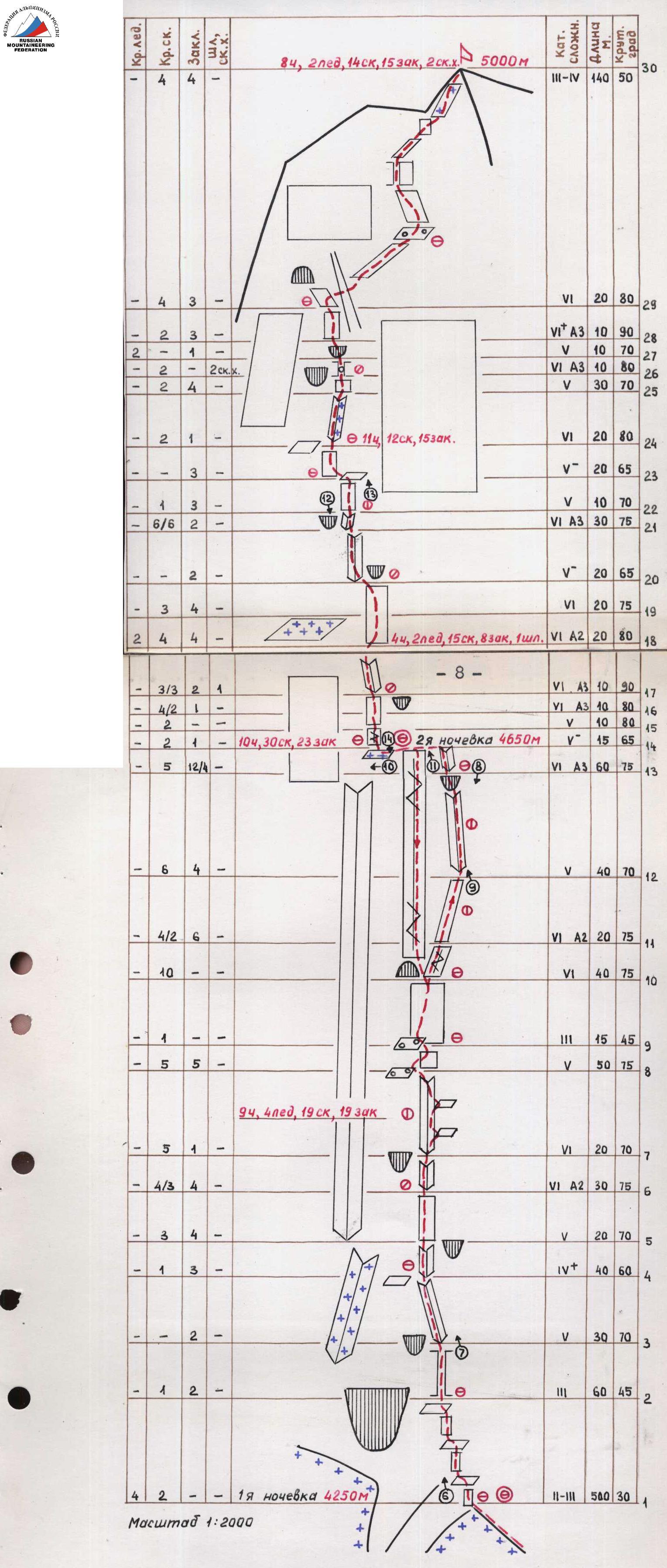
Fig. 10. Lower part of the route (photo 6). Taken on July 5, 1985 at 15:00 from bivouac 1, Jupiter-37A lens (F=135).

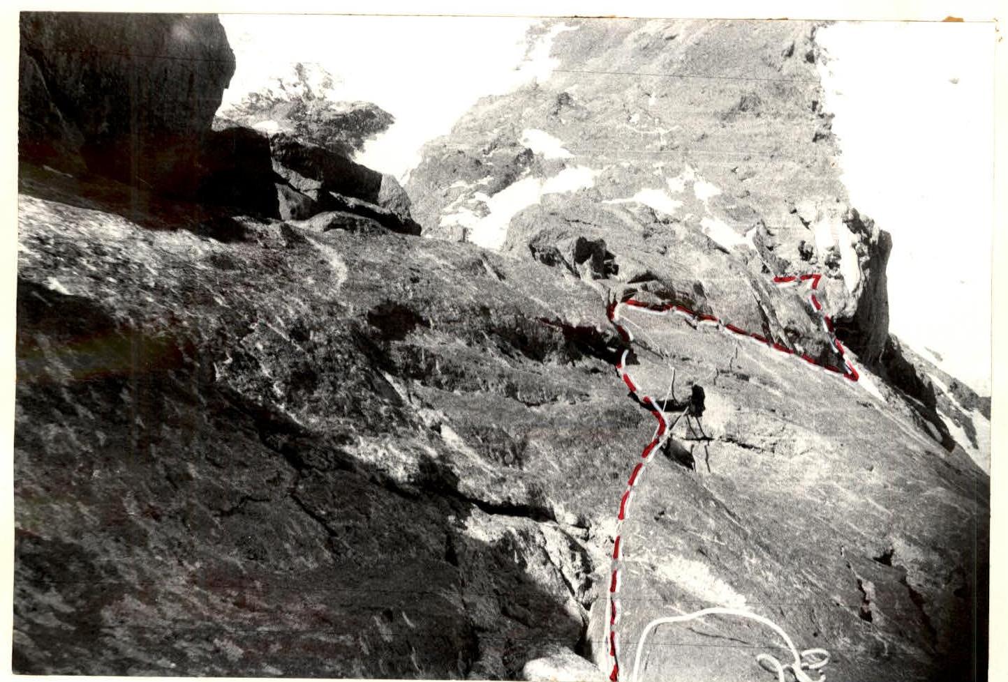
Fig. 17. Sections R23–R29 (photo 13). Taken on July 9, 1985 at 13:00 from section R22–R23, Mir-1 lens (F = 36).

Fig. 18. View from the ledge (photo 14) on the lower part of the route (descent path). Taken on July 10, 1985 at 16:00 from bivouac 2, Jupiter-37A lens (F = 135).
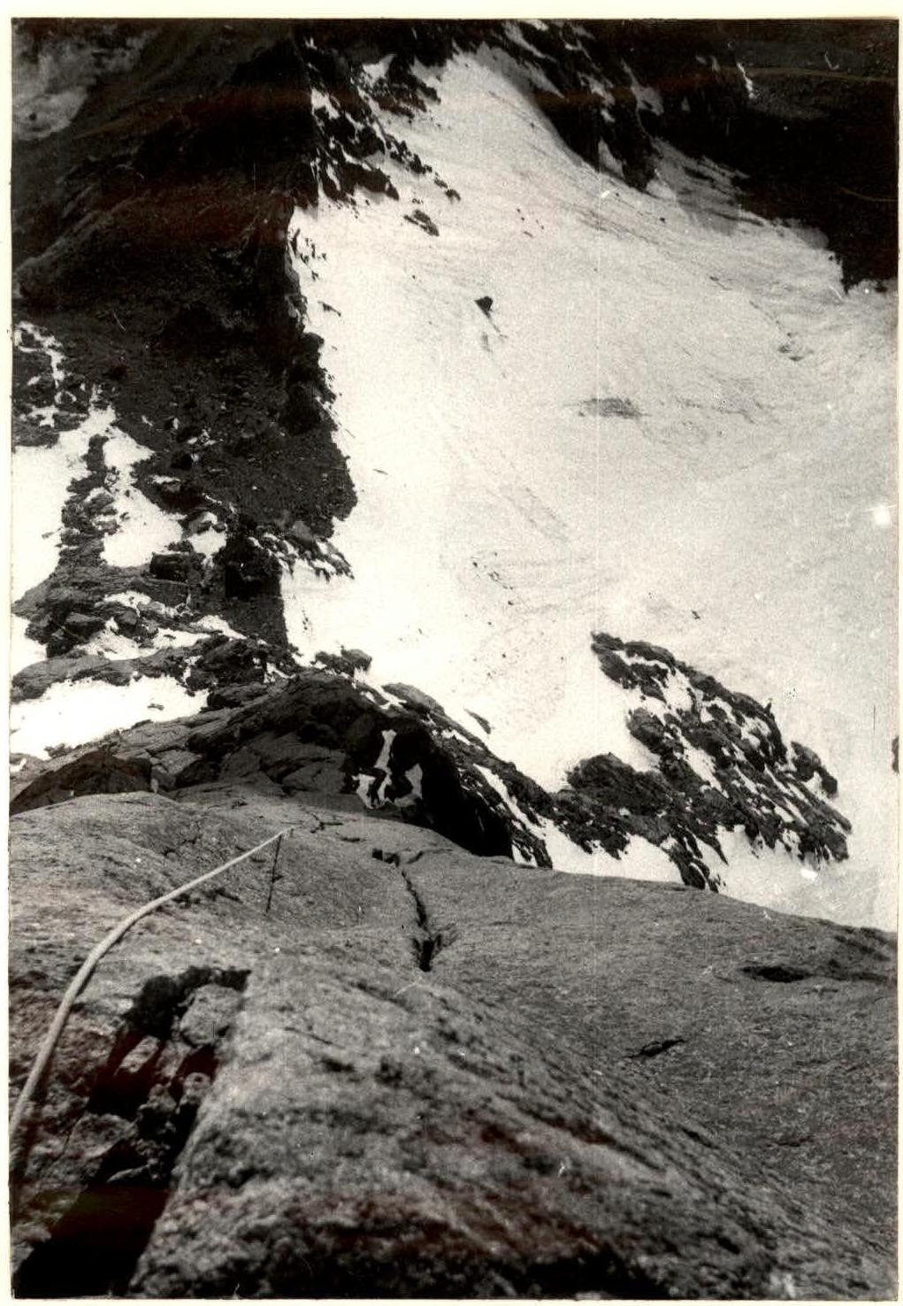
Fig. 15. Upper part of the route (photo 11). Taken on July 8, 1985 at 15:00 from bivouac 2, Jupiter-37A lens (F = 135).
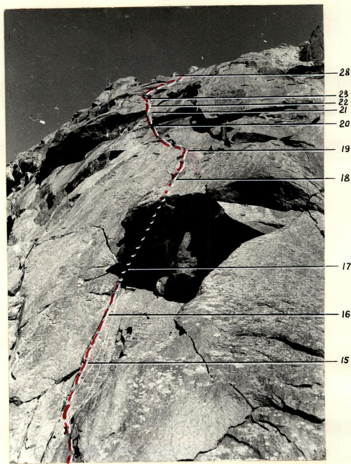
Fig. 16. Sections R14–R22 (photo 12). Taken on July 9, 1985 at 12:00 from section R22–R23, Mir-1 lens (F = 36).