- Climbing class - rock.
- Climbing area - Pamir-Alay, Turkestan Ridge, Ak-Su gorge.
- Object of ascent - p. "3900" (v. Domashnaya) along the southwestern ridge.
- Estimated category of difficulty - 4B.
- Route characteristics: height difference - 660 m, length - 800 m, average steepness - 56°, length of sections 5 category of difficulty - 140 m, length of sections 4 category of difficulty - 155 m, length of sections 1 category of difficulty - 340 m.
- Pitons hammered: rock 42, chocks 6.
- Travel hours - 9.
- Overnights - none.
- Group composition: Cherevatsky Alexander Moiseevich, 1st sports category, Simakov Nikolai Viktorovich, 1st sports category.
- Coach: Kudryashov Valery Sergeevich, Candidate Master of Sports.
- Exit to the route - June 30, 1984, summit - June 30, return - June 30.
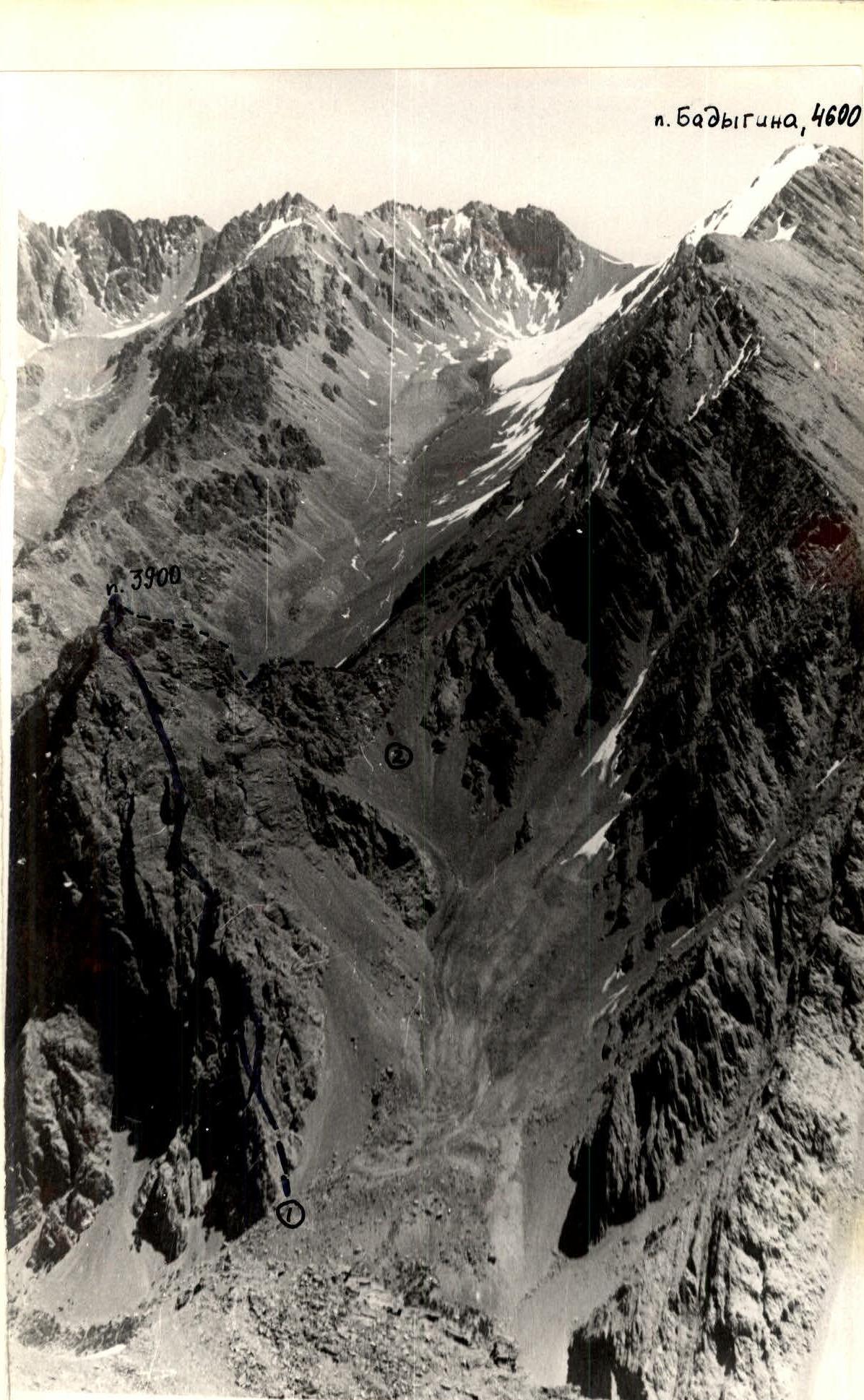
Photo 1. Shooting point No. 2. h = 4382 m. L = 3–3.5 km. (1 h 30 min). Lens И-50-2. F = 50 mm. June 24, 1984. (1) - proposed route 4B category of difficulty along the SW ridge. (2) - route 2B category of difficulty (descent path).
Route description by sections
Sect. R0–R1. From the talus enter the chimney located under the "comma". Along the chimney 30 m (55°) to the ledge. 1 piton, 4 category of difficulty. Sect. R1–R2. From the ledge along the wall 30 m (70°) up to a small ledge. On the ledge is a control cairn. 4 pitons, 5 category of difficulty. Sect. R2–R3. From the ledge along the wall 30 m (60°) up to a small ledge. 3 pitons, 2 chocks, 4 category of difficulty. From the ledge left upwards 20 m along the wall (60°). 3 pitons, 1 chock. 4 category of difficulty. Then upwards along the wall 35 m (50°) to a narrow ledge on the wall of the upper part of the wide talus couloir. 3 pitons. 4 category of difficulty. Sect. R3–R4. Along the ledge (8 m) descend into the couloir, cross it along the talus left upwards and along short walls and ledges 50 m (55°) ascend to a site under the wall. 3 category of difficulty. Rockfall hazard. Sect. R4–R5. From the site along a narrowing chimney 40 m (70°) to an inclined talus ledge. 5 pitons. 5 category of difficulty. Sect. R5–R6. Further along talus ledges and walls 5–8 m high (50°) 170 m to a large tower, which is bypassed along ledges on the right. Exit under the internal angle. 2–3 category of difficulty. Sect. R6–R7. Along the internal angle upwards 35 m (55°) under overhanging rusty rocks. 1 piton. 3 category of difficulty. Then right upwards along the wall 30 m (45°), along a ledge 10 m (35°) and a wall 5 m high (60°) bypass the wall to a ledge. 3 pitons. 3 category of difficulty. Sect. R7–R8. Along the ledge rightwards bypassing the wall and then along a talus ledge (40°) to the junction of two walls under overhanging rocks - a total of 40 m. 1 piton, 2 chocks. 3 category of difficulty. Sect. R8–R9. Along the left side of the angle upwards 40 m (70°) to the ridge. 5 pitons. 4 category of difficulty. At this point, the route intersects with the route 4B category of difficulty along the NW ridge. A convenient bivouac site. Sect. R9–R10. From the ridge along a ledge rightwards along the wall 30 m to a vertical protrusion in the wall. 1 piton. 2 category of difficulty. Left of the protrusion along the wall upwards 15 m (70°), then along the internal angle upwards 20 m (60°) to talus ledges. 5 pitons. 5 category of difficulty. Sect. R10–R11. Along talus ledges and walls rightwards upwards 50 m (50°) to an internal angle. Along the angle 20 m (50°) (rockfall hazard), then 40 m leftwards upwards along a talus slope (35°) to the ridge. 2 pitons. 3 category of difficulty. Sect. R11–R12. From the ridge rightwards upwards along the wall 35 m (80°) with an exit to the ridge above a sheer rock. 6 pitons, 1 chock. 5 category of difficulty. Sect. R12–R13. Along a wide ridge 90 m of uncomplicated climbing to the summit. Control cairn. 2 category of difficulty.
Descent. Descent is made along the SE ridge by route 2B category of difficulty to a saddle and then along the talus to the Ak-Su River and further - to the base camp.
| Section No. | Average steepness (degrees) | Length (m) | Terrain characteristics | Route condition | Weather conditions | Category of difficulty | Pitons | Chocks | Movement character |
|---|---|---|---|---|---|---|---|---|---|
| R0–R1 | 55 | 30 | Monolith | Solid rocks. Good | 4 | 1 | - | Alternating | |
| R1–R2 | 70 | 30 | Monolith | Solid rocks. Good | 5 | 4 | - | Alternating | |
| R2–R3 | 60 | 85 | Monolith | Solid rocks. Good | 4 | 9 | 3 | Alternating | |
| R3–R4 | 55 | 50 | Monolith | Rockfall hazard, good | 3 | - | - | Alternating | |
| R4–R5 | 70 | 40 | Monolith | Solid rocks. Good | 5 | 5 | - | Alternating | |
| R5–R6 | 50 | 170 | Alternating ledges and walls | "Live" stones, good on ledges | 2–3 | - | - | Sometimes simultaneous | |
| R6–R7 | 55 | 80 | Monolith | Solid rocks. Good | 3 | 4 | - | Alternating | |
| R7–R8 | 40 | 40 | Monolith | Solid rocks. Good | 3 | 1 | 2 | Alternating | |
| R8–R9 | 70 | 40 | Monolith | Solid rocks. Good | 4 | 5 | - | Alternating | |
| R9–R10 | 65 | 35 | Monolith | Solid rocks. Deterioration, strong wind | 5 | 5 | - | Alternating | |
| R10–R11 | 50 | 70 | Monolith | In the upper part of the internal angle "live" stones | 3 | 2 | - | Alternating | |
| R11–R12 | 80 | 35 | Monolith | Solid rocks. Rain | 5 | 6 | 1 | Alternating | |
| R12–R13 | 40 | 90 | Monolith | Solid rocks. Snow pellets | 2 | - | - | Simultaneous |
Route diagram in UIAA symbols.
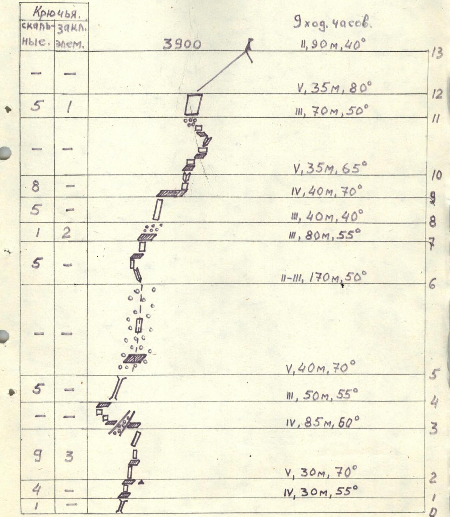
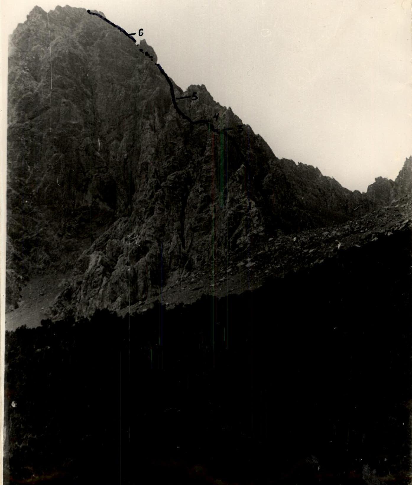
Photo 2. p. 3900 m.
- Shooting point No. 1
- h = 2950 m
- L = 1.5 km
- Lens И-50-2
- F = 50 mm
- June 29, 1984.
- 17 h 30 min
- Section numbers are indicated