- Climbing type — rock climbing
- Climbing area — Pamir-Alay, Turkestan Range, Ak-Su gorge.
- Summit — Peak 3900 m via North-Eastern ridge.
- Difficulty category — 4A
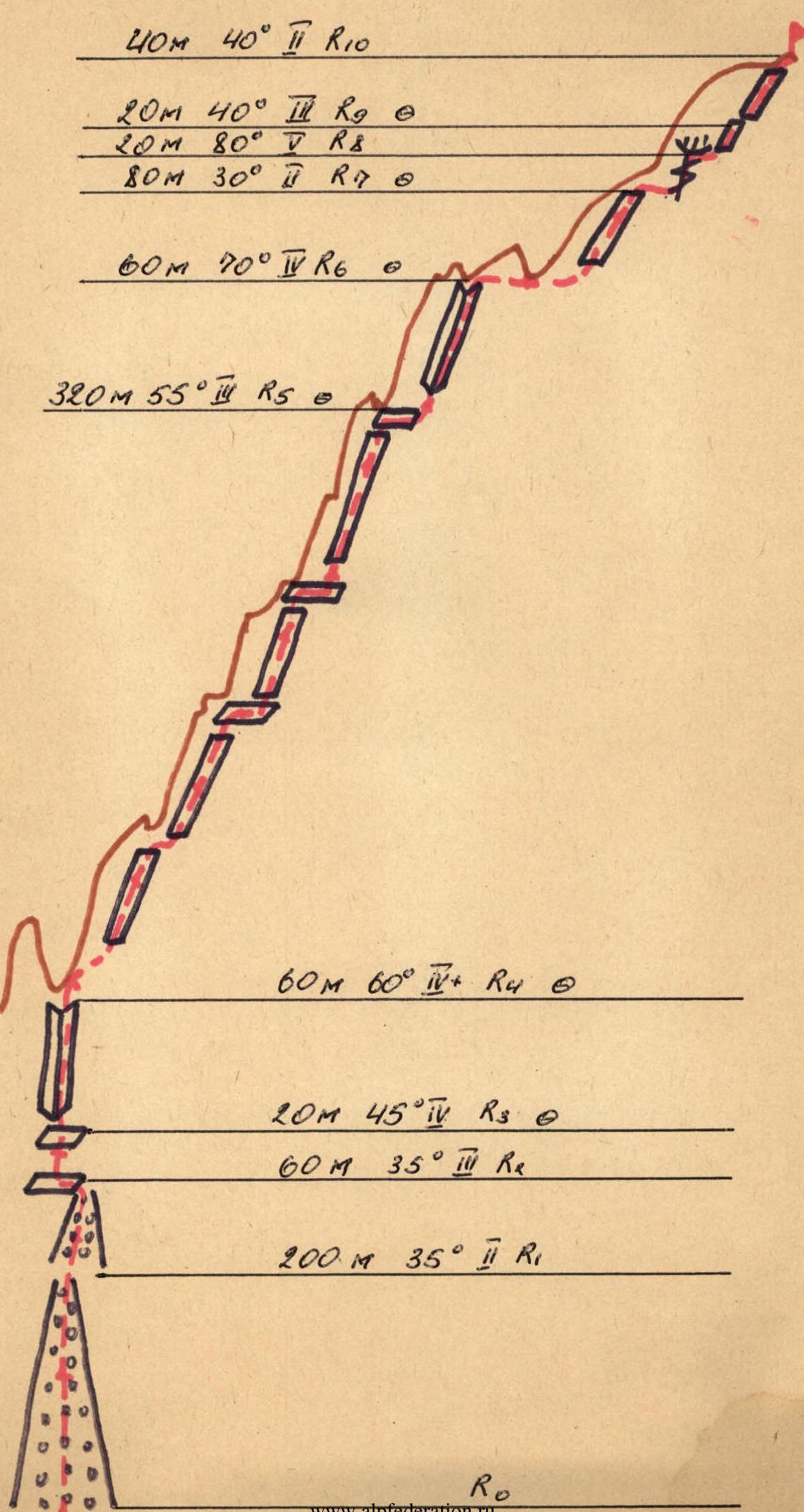
- Route characteristics:
- Elevation gain — 660 m;
- Length of sections with IV–V difficulty category — 160 m, including: IV category — 140 m, V category — 20 m. Average steepness of the route — 45°.
- Pitons hammered:
- Rock pitons — 18;
- Chocks — 9.
- Total climbing hours — 6 hours.
- The route is completed in 1 day. A convenient overnight stop is possible at the R6–R7 section and on the descent.
- Group of 4 people:
Leader — Chuprina A.I. Sr.
Members:
- Didenko V.P. Sr.
- Sytnik D.N. Sr.
- Pyshkin A.V. Sr.
- Coach — Prikhodchenko A.I., CMS.
- Ascent completed on August 14, 1984.
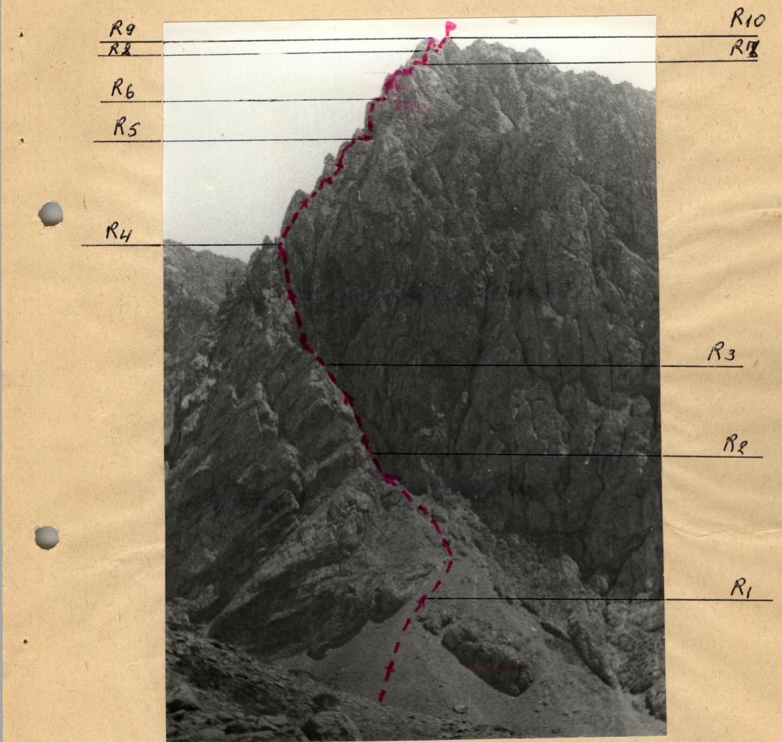
General view of the summit. Route sections table.
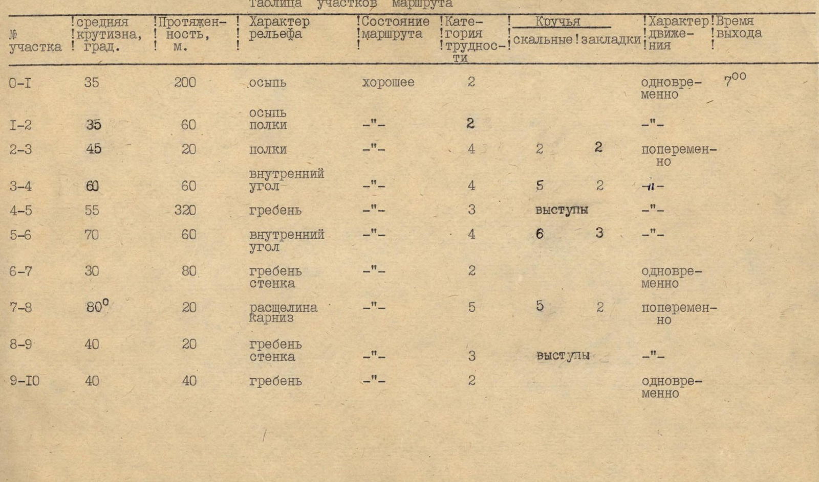
Route sections table
| Section | Average steepness, ° | Length, m | Terrain characteristics | Route condition | Difficulty category | Rock pitons | Chocks | Movement type | Exit time |
|---|---|---|---|---|---|---|---|---|---|
| R0–R1 | 35° | 200 | scree | good | 2 | simultaneous | 7:00 | ||
| R1–R2 | 35° | 60 | scree, ledges | -" | 2 | simultaneous | |||
| R2–R3 | 45° | 20 | ledges | -" | 4 | 2 | 2 | alternating | |
| R3–R4 | 60° | 60 | inner corner | -" | 4 | 5 | 2 | alternating | |
| R4–R5 | 55° | 320 | ridge | -" | 3 | outcrops | alternating | ||
| R5–R6 | 70° | 60 | inner corner | -" | 4 | 6 | 3 | alternating | |
| R6–R7 | 30° | 80 | ridge, wall | -" | 2 | simultaneous | |||
| R7–R8 | 80° | 20 | crack, cornice | -" | 5 | 5 | 2 | alternating | |
| R8–R9 | 40° | 20 | ridge, wall | -" | 3 | outcrops | alternating | ||
| R9–R10 | 40° | 40 | ridge | -" | 2 | simultaneous |
Explanations for the route sections table
Sections:
R0–R1 — up a wide scree couloir 200 m to the narrowing.
R1–R2 — left and up to a horizontal ledge 60 m, simultaneous movement.
R2–R3 — up ledges 20 m at 45°, alternating movement, piton belay.
R3–R4 — up an inner corner 60 m at 60°, alternating movement, piton belay, exit under a reddish gendarme.
R4–R5 — up a wall with inclined and horizontal ledges, alternating movement, belay via outcrops or chocks, up and right along the ridge 320 m.
R5–R6 — up an inner corner, alternating movement, up to an inclined slab 60 m, piton belay.
R6–R7 — along the slab (ledge) 80 m up and right onto the ridge, piton belay, along the ridge, alternating movement, exit to the key section.
R7–R8 — up a vertical ledge at 80° 20 m to two diagonal cracks on the right, a cornice, up the cracks to a ledge, piton belay.
R8–R10 — along the ridge 80 m to the summit, alternating belay.
Ascent route diagram to Peak 3900 m via the NE ridge.