WORLD ALPINISM CHAMPIONSHIP
TECHNICAL CLASS
REPORT
On the ascent of the team A/K "Odessa" to Pik Bloka
Via the North face, first ascent.
Odessa, 2013
Ascent Passport
-
Pamir-Alay. Turkestan range. Laylyak valley
-
Pik Bloka, 5239 m via the center of the North face
-
Proposed grade — 6A, first ascent
-
Route type: mixed
-
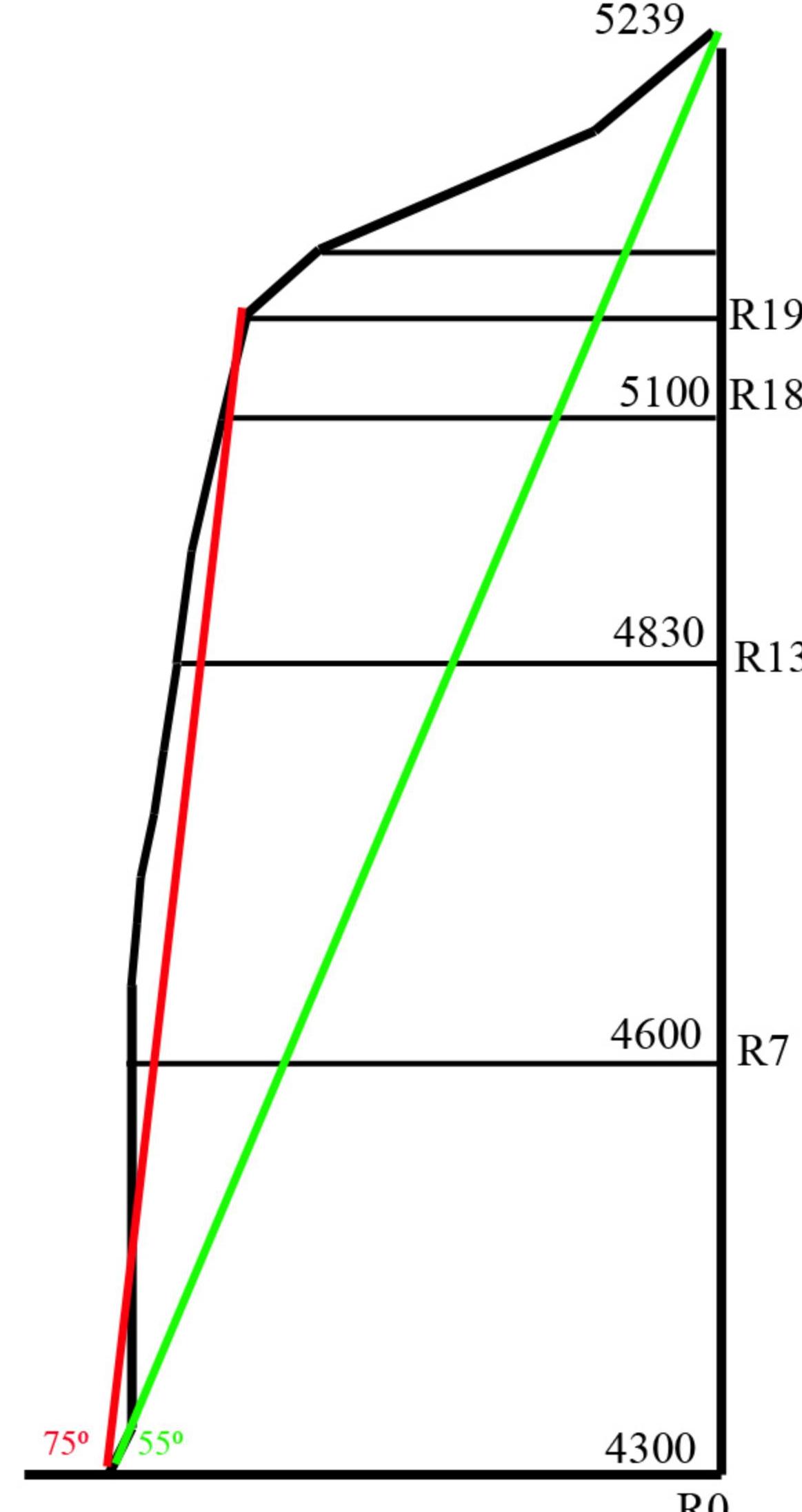
Route elevation gain: 939 m (by GPS)
Route length: 1490 m. Length of sections:
- grade 5: 265 m
- grade 6: 610 m
Average steepness:
- main part of the route — 75°
- whole route — 55°
-
Pitons left on the route:
Total: 22; including bolted pitons: 20 Used on the route:
- pitons: 151/95
- nuts: 110/70
- skyhooks: 5
- bolted pitons: 20/2
- ice screws: 39
-
Team's climbing hours: 68 h, 9 days
-
Team leader:
Lavrynenko A.V. MS Team member: Perevalov M.V. MS
-
Coach: Gorbenko Mstislav Mstislavovich ZTU
-
Start of the route
Route started: July 17, 2013 11:00 Reached the summit: July 25, 2013 19:50 Returned to Base Camp: July 26, 2013 20:00 Descent from the summit: via the ascent route
-
Organization: a/k Odessa
-
Report responsible: Lavrynenko A.V. +380662489138 odlavr@gmail.com
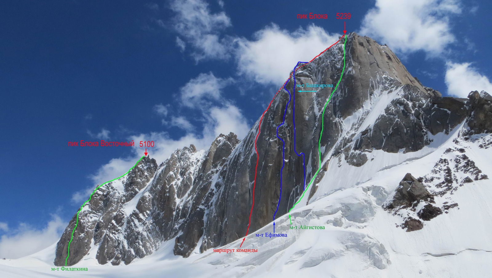
Mt. Filatkina Pik Bloka 5239 North face
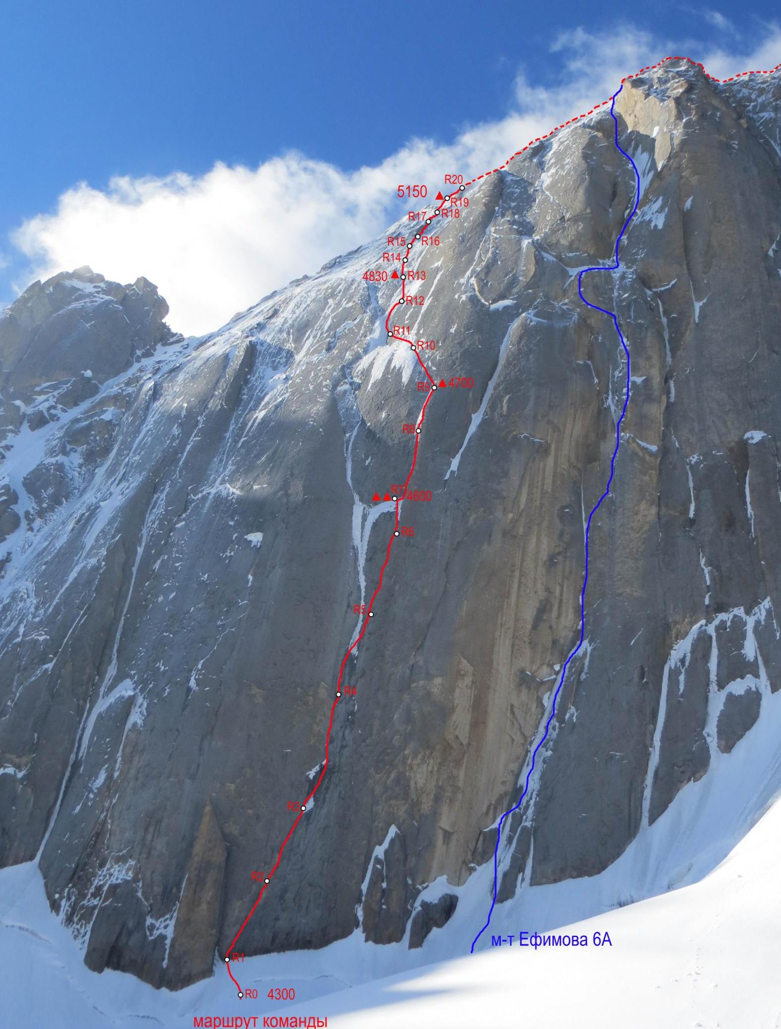
section R1–R2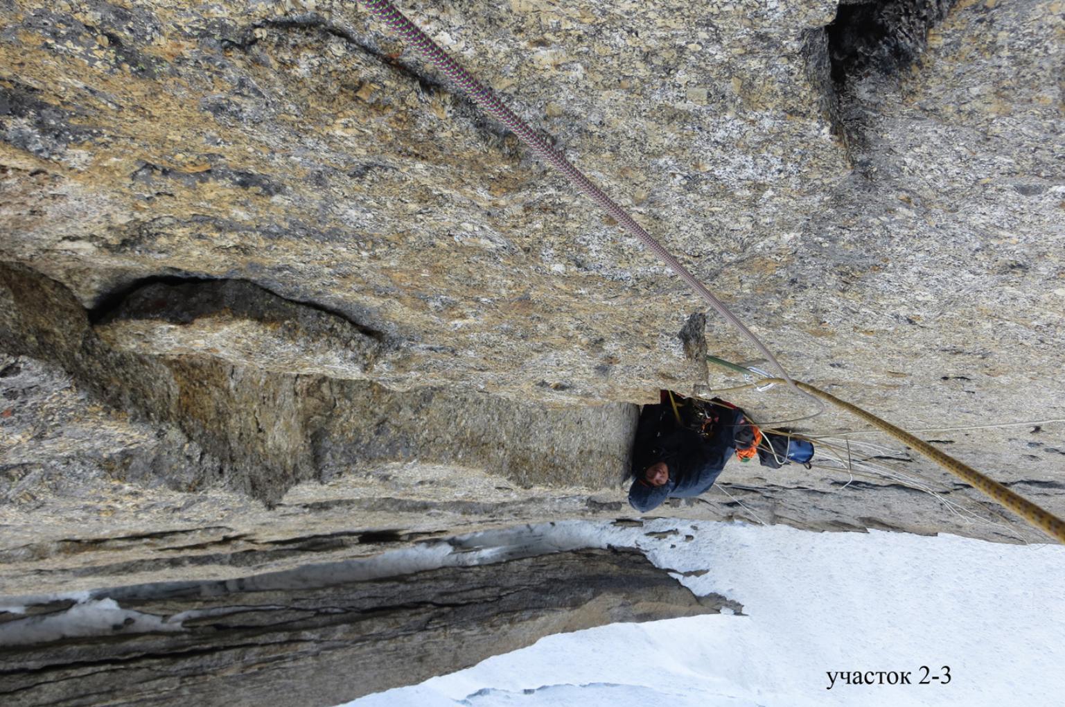
section R2–R3
section R3–R4
Section R1–R7
section R5–R6, section R7–R8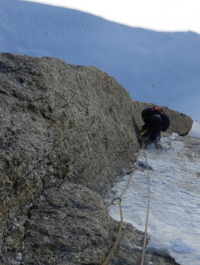
section R8–R9, section R9–R10, R10–R11, R11–R12, section R17–R19
Route diagram in UIAA symbols
Sheet 1
| pitons | nuts | skyhooks | bolts | № | length | steepness | difficulty |
|---|---|---|---|---|---|---|---|
| 12 | 5 | 3 | R8–R9 | 50 m | 75° | 5A2 | |
| 14 | 2 | 1 | R7–R8 | 50 m | 85° | 5A3 | |
| 7 | 1 | R6–R7 | 20 m | 80° | 5A1 | ||
| 2 | 12 | 2 | R5–R6 | 40 m | 85° | 5A2 | |
| 10 | 9 | 1 | R4–R5 | 55 m | 90° | 5A3 | |
| 9 | 12 | 3 | R3–R4 | 45 m | 85° | 5A2+ | |
| 12 | 8 | 1 | R2–R3 | 50 m | 85° | 5A2 | |
| 8 | 10 | 1 | R1–R2 | 45 m | 80° | 5A2 | |
| 2 | R0–R1 | 60 m | 45° | 3 |
Sheet 2
| pitons | nuts | skyhooks | bolts | № | length | steepness | difficulty |
|---|---|---|---|---|---|---|---|
| 4 | 5 | R19–R20 | 50 m | 65° | 5 | ||
| 6 | 1 | 5 | R18–R19 | 60 m | 70° | 6 | |
| 1 | 4 | R17–R18 | 40 m | 50° | 5 | ||
| 3 | 4 | 1 | R16–R17 | 45 m | 70° | 5A1 | |
| 5 | 2 | 3 | R15–R16 | 40 m | 50° | 5 | |
| 4 | 3 | R14–R15 | 60 m | 60° | 5+ | ||
| 9 | 1 | 6 | R12–R13 | 60 m | 70° | 6 | |
| 8 | 3 | 5 | R11–R12 | 45 m | 75° | 6 | |
| 5 | 1 | 4 | R10–R11 | 30 m | 60° | 5+A1 | |
| 12 | 8 | 1 | R9–R10 | 45 m | 70° | 5A3 | |
| R13–R14 | 45 m | 60° | 5 |
Sheet 3
| pitons | nuts | skyhooks | bolts | № | length | steepness | difficulty |
|---|---|---|---|---|---|---|---|
| 7 | 15 | R21–R22 | 250 m | 45° | 3 | ||
| 10 | 8 | R20–R21 | 200 m | 50° | 3 |
Route description by sections
Approach to the start of the route via a snow-ice slope, steepness gradually increases to 40°. Approach under the bergschrund, where it splits.
R0–R1. 60 m. 3. Through the bergschrund, then along the snow-ice slope at 45° to the start of a diagonal crack. Left an 8 mm anchor without a lug.
R1–R2. 45 m. 80°. 5A2. Upwards to the right along a steep, partly overhanging crack. The crack is covered by a "visor" protecting from falling ice and rocks. Belay station under an overhang.
R2–R3. 50 m. 85°. 5A2. Upwards to the right, along an inside corner overhanging at the bottom, exit into a "room" protected by a cornice. Belay station.
R3–R4. 45 m. 85°. 5A2+. Along an overhanging inside corner for 15 m, then along a wide (15-20 cm) ice-filled crack upwards under a cornice. Belay station under the cornice.
R4–R5. 55 m. 90°. 5A3. Upwards through the cornice, then along an overhanging corner for 20 m, further the corner "reclines" but becomes dangerous, ice falls, water flows. Traverse to the right onto a diagonal crack.
R5–R6. 40 m. 85°. 5A2. Upwards along the crack. The crack is steep but convenient for placing protection (nuts, cams). Belay station on a bolt, with a foot ledge.
R6–R7. 20 m. 80°. 5A1. Upwards along an ice-filled fissure, exit onto an inclined, iced ledge — the site of the first and second bivouacs.
R7–R8. 50 m. 85°. 5A3. Upwards along an ice-filled chimney, the first 10 m on thin ice on front-points, difficult to place protection. Further on the right wall of the chimney appear dead cracks, it becomes safer. The chimney turns into an inside corner, upwards along the corner. Belay station under an overhang.
R8–R9. 50 m. 75°. 5A2. Through a small overhang, then along a corner filled with ice. Initially on front-points on ice, ice screws not fully screwed in, further along the right side of the corner appears a system of cracks, movement partly on ice, partly on ITO along the cracks. Belay station on a gentle slope. Site of the 3rd bivouac.
R9–R10. 45 m. 70°. 5A3. Along a diagonal crack leftwards upwards. The crack is formed by "ringing" flutings, many "live" placements. Belay station on a ledge.
R10–R11. 30 m. 60°. 5+A1. Along rocks and ice leftwards upwards. Belay station on a gentle slope, bolts hammered into a "ringing" slab.
R11–R12. 45 m. 75°. 6. From the belay station traverse left, exit onto an ice "snot" along it upwards, along the right rocks. Belay station on a rock, with a bolt.
R12–R13. 60 m. 70°. 6. From the belay station leftwards upwards, cross an ice "river", further along an inside corner filled with ice, movement partly on ice, partly on rocks. Belay station on a gentle slope under an overhang. Site of the 4th bivouac.
R13–R14. 45 m. 60°. 5. Continuation of the inside corner, exit onto a gentle slope.
R14–R15. 60 m. 60°. 5+. Leftwards upwards, move along ice, avoiding rocks, ice is thin, ice screws not fully screwed in, protection on rock outcrops.
R15–R16. 40 m. 50°. 5. Upwards left along ice, approach under an overhanging inside corner.
R16–R17. 45 m. 70°. 5A1. Through the overhanging corner, further along ice exit onto a rock ridge. Belay station 5 meters higher on a bolt.
R17–R18. 40 m. 50°. 5. From the belay station descend onto the ridge, then traverse left along a steep snow-ice slope, then upwards along steep ice. Belay station at the exit of rocks. Bolt.
R18–R19. 60 m. 70°. 6. Upwards left, along steep ice, approach under a rock wall. Through the wall along a crack, exit onto a ridge. On the south side of the ridge — the 5th bivouac.
R19–R20. 50 m. 65°. 5. Along a steep, narrow ridge upwards, exit onto a gentle part of the ridge.
R20–R21. 200 m. 50°. 3. The further part of the ridge does not present serious technical difficulties. Initially along a horizontal ridge for 50 m, then along the south side descend into a depression of the ridge, further along the ridge upwards, to the point of Yefimov's route exit.
R21–R22. 250 m. 3. Along the ridge towards the summit. Exit to the summit along a steep snow-ice slope for 30 m, then along simple rocks.
Tactical actions of the team
The center of the North face of Pik Bloka is not explored, Yefimov's, Korobkov's and Bashkirov's routes go significantly to the right, along the "pillar". The lower part of the face — a steep rock bastion. The upper part — corners filled with ice, ice "rivers". There are no ledges suitable for bivouacking on the face. In cold weather, the route is safe. When ice melts in the upper part — high rockfall danger.
The team started the route after a prolonged bad weather. The face was just starting to thaw. Most of the ice flew over the rock bastion and fell below the bergschrund, but still, during the processing, we had to hide under overhangs. We could work until 15:00-16:00. Later, along the line of movement, water started flowing, and pieces of ice were falling. Six sections were completed. After 4 days, the state of the face stabilized, and we "took off" from the ground. For bivouacking on the route, a platform was used. All bivouac sites are safe. We worked on the route alternately. For protection, a double rope was used.
On July 25, the team reached the ridge and on the same day, in the evening, reached the summit. No notes were found in the cairn. Left our own note, which was taken down by the Kharkov team two days later. Descent was made via the ascent route. Most of the belay stations on the route are equipped with bolts (l = 35 mm; d = 8 mm).
It should be noted that ascents on the North face of Pik Bloka are rare, the last one being Korobkov's team in 2007. Our route is completely independent and logical, with rare exceptions, only natural relief was used. (5 holes were drilled for a skyhook and 2 bolted pitons for ITO). To the left of our route, several lines of 5-6 grade are possible.
We consider our route to correspond to 6A grade. The team has extensive experience in climbing 6A and 6B grade routes. Additional data on the elevation gain and route length can be found in the appendix.
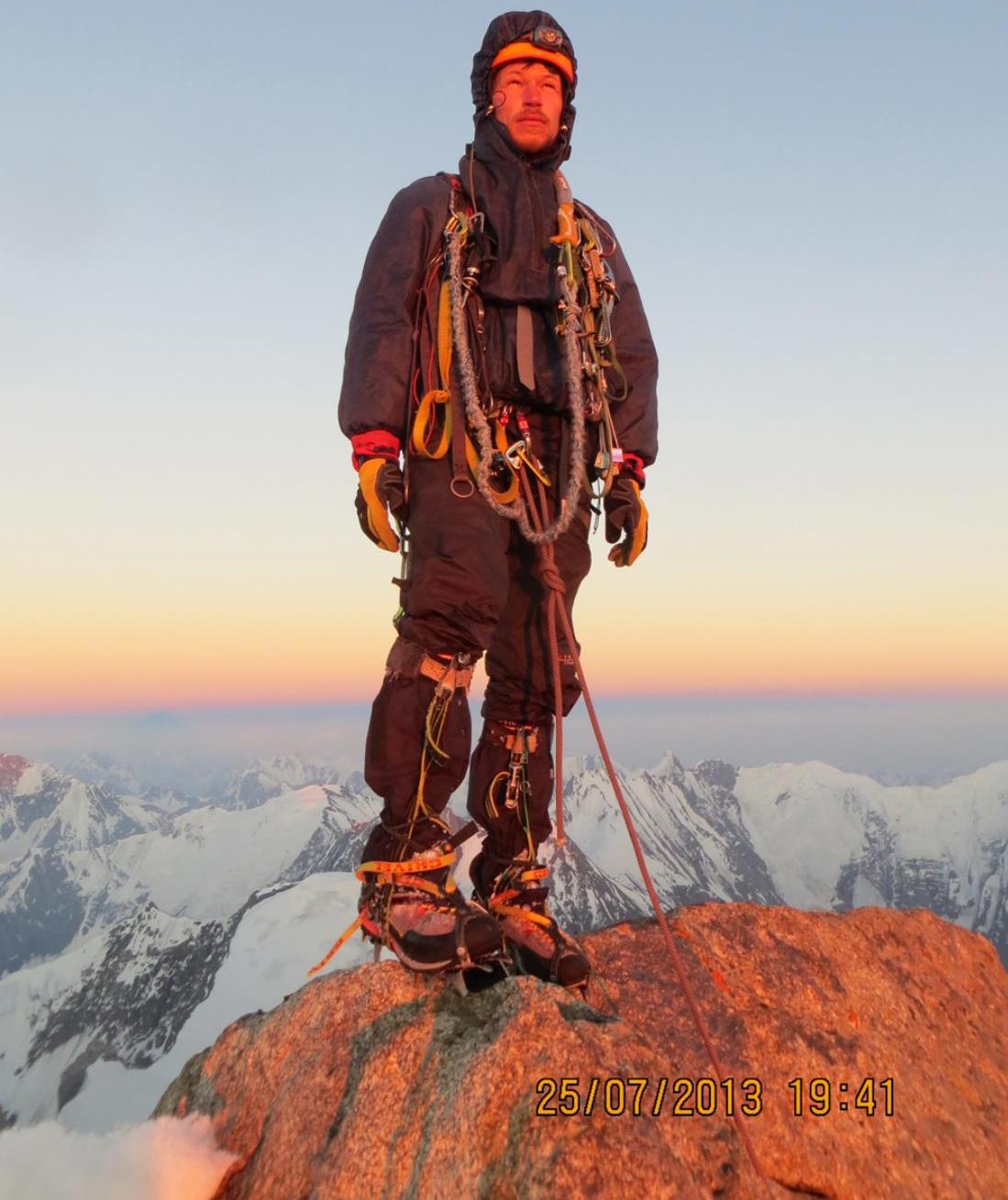
July 25, 2013 19:41
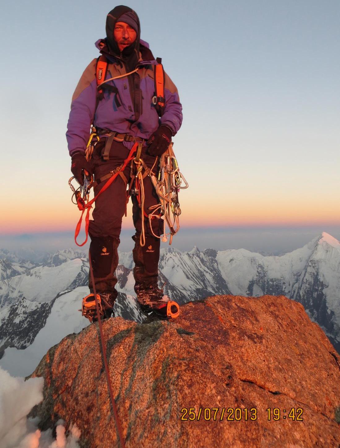
July 25, 2013 19:42