Ascent Log
- Technical category.
- Pamir-Alay, Turkestan Range, Ak-su valley.
- Peak Aktyubek (5125 m) via the right counterfort of the North face.
- Proposed category 5A, first ascent.
- Height difference — 1325 m.
Total length: 2435 m, sections of category 5 — 200 m. Slope: overall on the route — 38°, on the wall section — 50°. 6. Pitons hammered: rock — 25, ice — 11. Chocks placed — 34. 7. Number of travel days — 3, hours — 24. 8. Number of bivouacs on the route — 2 (both convenient, in a tent). 9. Leader — Vasiliev S.I., 1st sports category. Participants: * Bolshov L.A., 2nd sports category * Magnitsky B.V., 1st sports category * Presnov E.V., 1st sports category 10. Coach — Kozlov Yu.E., Master of Sports. 11. Approach to the route — July 22, 1984. Summit ascent — July 24, 1984. Return to base camp — July 24, 1984. 12. Weather conditions — clear throughout the entire ascent.
Brief Description of the Approach
From the base camp, the path goes along the right (orographic) bank of the Ak-su river past the western slopes of v. Domashnaya to the end of the juniper forest.
Then, before reaching the moraine of the Ak-su glacier, turn left into a side gorge in the direction of the Aktyubek pass. At the beginning, there is an ascent on a steep rise along the left bank of the stream, and then, having reached the expansion of the gorge (1.5 km from the tongue of the glacier), cross to the right bank.
Here, on the scree slopes opposite the right counterfort of the northern wall of the peak Aktyubek (slightly below the tongue of the glacier) — a convenient and safe place for the initial bivouac (3.5–4 hours).
It is not recommended to camp on the left bank directly under the route due to the danger of rockfall, especially in the second half of the day.
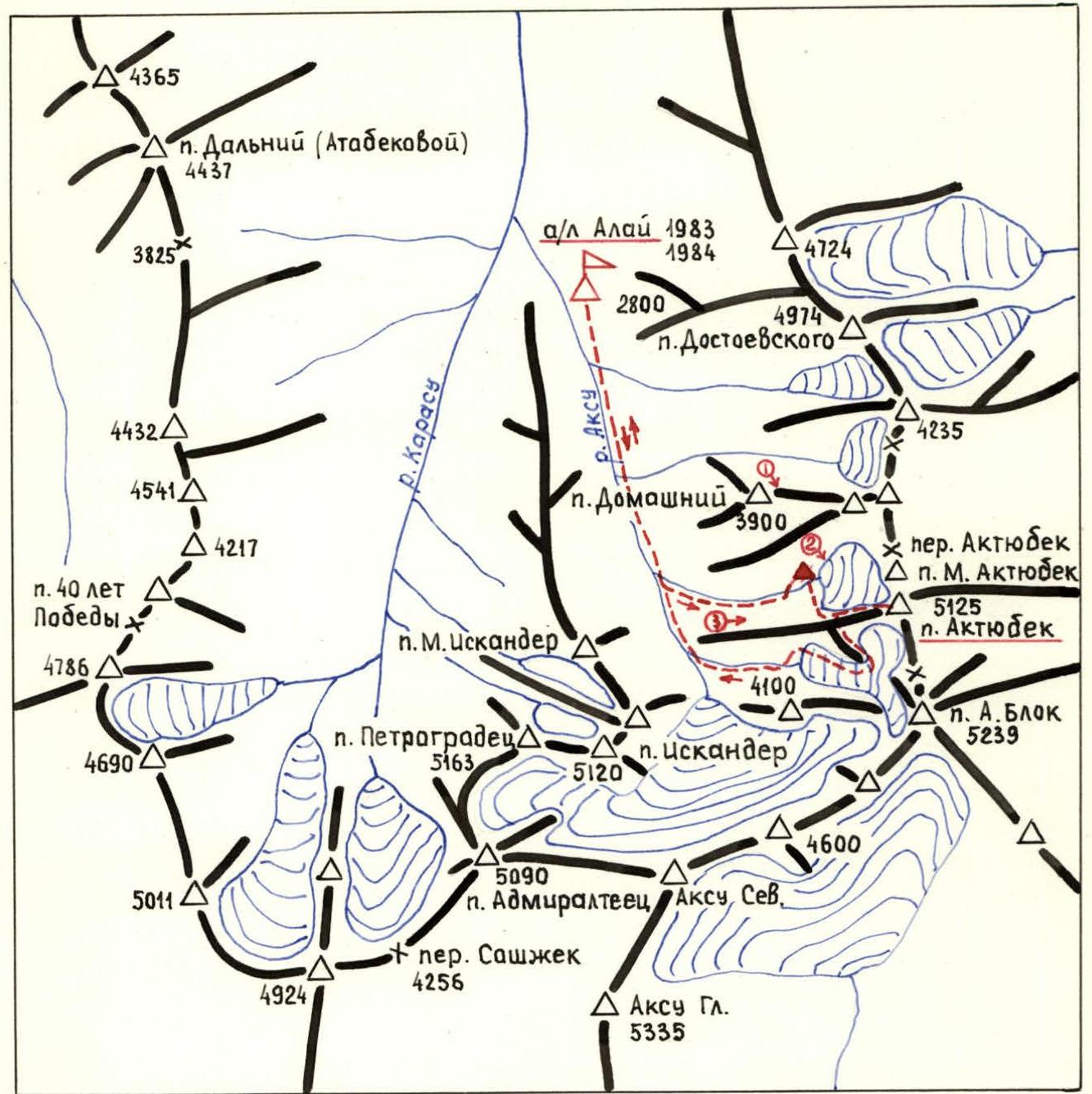
Scale 1:100000
Conventional symbols
- base camp
- photo shooting points
- group route
- initial bivouac
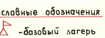
Fig. 1. Schematic map of the Ak-Su valley.
Description by Sections
R1–R2. Ice slope at the base of the wall is traversed in crampons with piton belay.
R4–R5. Scree shelves with individual walls, many loose rocks. After ascending above the rocky bastion, traverse left to a vaguely defined inflection.
R5–R6. Traverse along a narrow shelf under a small wall with a chimney through which water flows. Sections of flow ice, loose rocks.
R6–R7. Wide, two-tiered chimney with good holds. Movement in the lower part is in a camming position. The chimney leads to the ridge of the right counterfort (6.5 hours).
Here, on a scree shelf, there is a control cairn.
R8–R9. Wall with good holds, with a smooth vertical upper part. The first person ascends without a backpack.
R10–R11. Many loose rocks. To the right, behind a shallow depression with a stream — steep, rockfall-prone walls.
R11–R12. Traverse left followed by ascent up three almost vertical monolithic walls with limited holds, alternating with narrow shelves. The first person ascends without a backpack using artificial aids.
R12–R13. Steep rocky massif on the left side of the counterfort with good cracks for chocks. Loose rocks.
Exit to a small ledge in the counterfort ridge under a large rocky bastion. Here is a platform for one tent, with a snowpatch nearby. The wall of the bastion protects from rockfall, which is possible in the second half of the day on both sides of it. The gully to the right of the counterfort is especially prone to rockfall.
R14–R15. Wall on the right part of the counterfort. Holds are limited; good cracks for chocks.
R15–R16. Holds are limited, loose rocks. An internal corner leads to a scree shelf.
R18–R19. Scree-covered wide ridge with a large scree shelf in the middle part.
R19–R20. Wide chimney with a large plug in the middle part. Chocks go in well.
R20–R21. Steep rocky ridge, becoming more complex in the upper part. To the left — an ice slope with steep drop-offs. After a multi-day period of clear warm weather, spontaneous rockfall is possible in the second half of the day, with rocks thawing out on the ice slope to the left.
R21–R22. Ice slope covered with a thin layer of snow. Traversed in crampons with piton belay.
R24–R25. Western ridge (upper part of a category 3 route). The presence of sports groups on this section during the ascent of the right counterfort of the north face is undesirable due to the risk of dislodging rocks.
Descent via a category 3 route to the glacier between peaks Aktyubek and A. Blok.
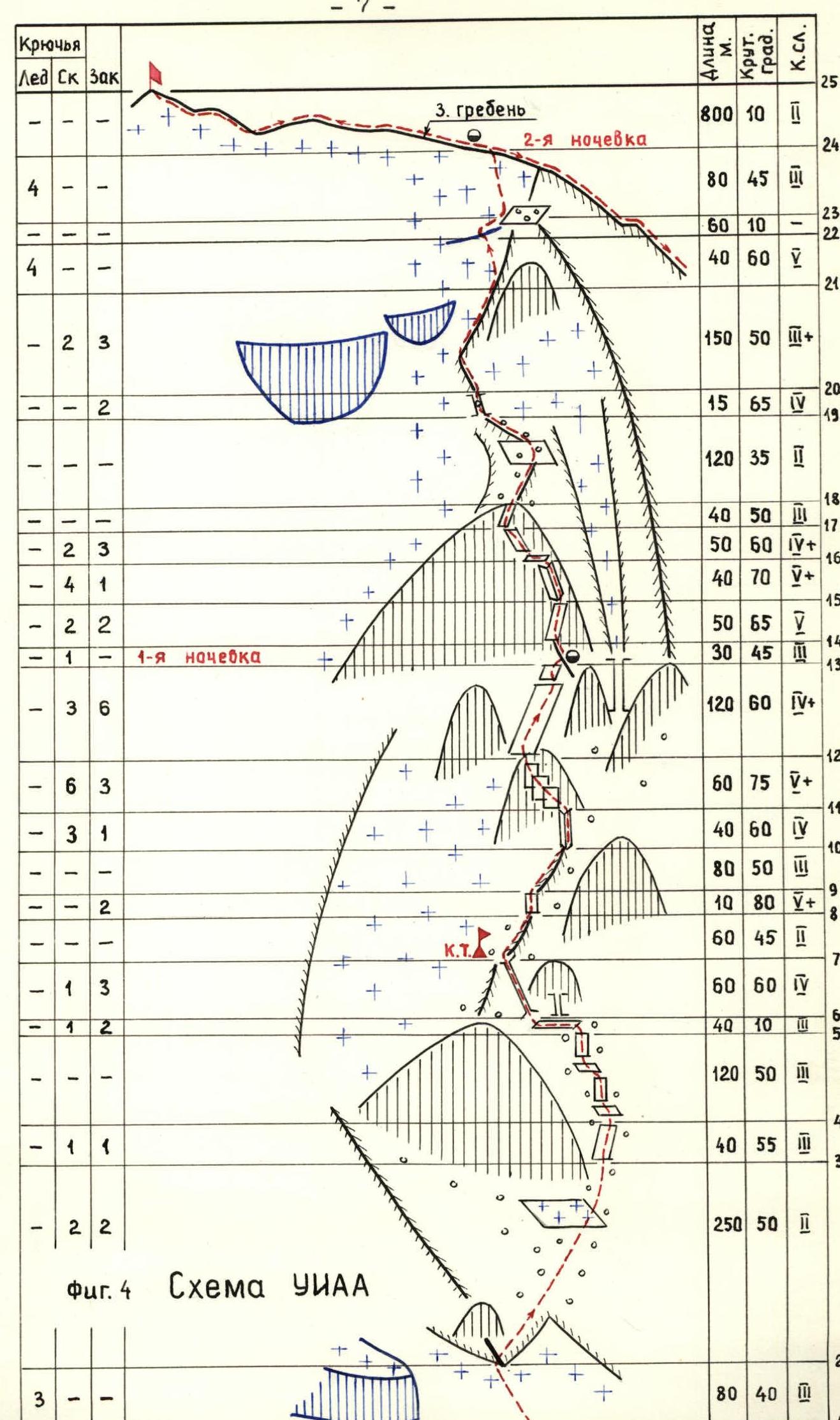
Fig. 2. Panorama of the summit. (Photo #1) Taken on July 5, 1983 at 10:00 from v. 3900 m (Domashnaya). Lens G-44-2 (F=58), distance — 4 km.
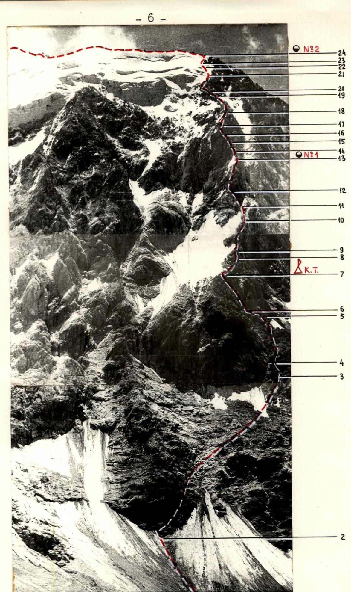
Fig. 3. Right counterfort of the north face (Photo #2) Taken on July 21, 1984 at 12:00 from the opposite slope of the gorge. Lens G-44-2 (F=58), distance — 1 km, height — 4300 m.
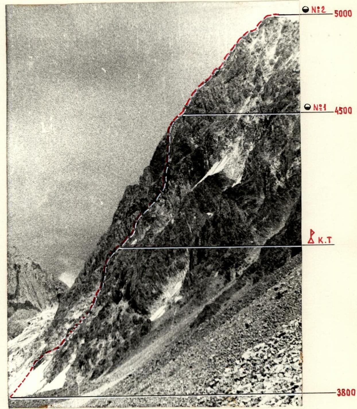
Fig. 5. Profile of the north face. (Photo #3) Taken on July 20, 1984 at 15:00 from the screes under the northern slopes of the western ridge. Lens G-44-2 (F=58), distance to the right counterfort of the north face — 2.5 km, height — 3300 m.