Ascent Log
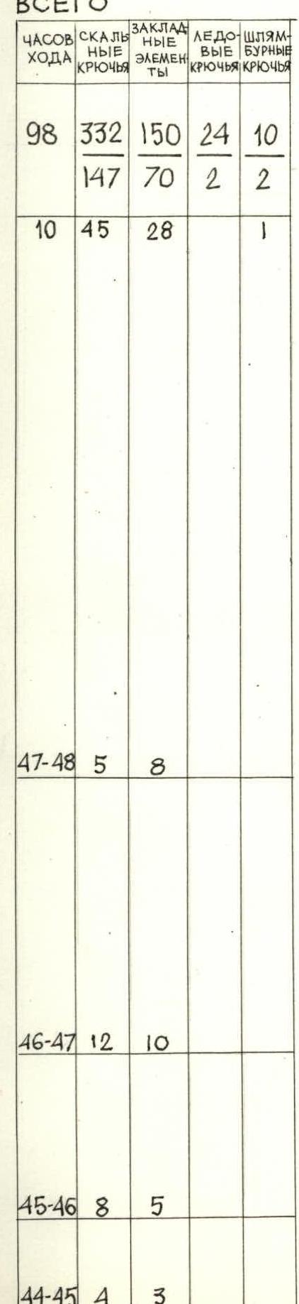
I. Category of first ascents. 2. Turkestan Range, Laylak valley 3. Peak Aksu Severnaia, 5217 m, via the center of the north face. 4. Proposed category: 6B, first ascent. 5. Elevation gain: 1467 m; route length: 1718 m. Length of sections with 5–6 category difficulty: 6B — 618 m, 5B — 715 m. Average slope of the route: 73°. 6. Pitons used:
| Rock pitons | Bolts | Nuts | Ice screws |
|---|---|---|---|
| 332 | 10 | 150 | 24 |
| 147 | 2 | 70 | 2 |
- Total climbing hours: 98 h, 10 days.
- Overnights: 10, all on hanging platforms.
- Team leader: POPOV VALERIY NIKOLAEVICH, Master of Sports of the USSR Team members: ZHILA ANDREY YUVINALEVICH, Master of Sports of the USSR KARATAEV VLADIMIR ALEKSANDROVICH, Master of Sports of the USSR DONSKOY KONSTANTIN DMITRIEVICH, Candidate for Master of Sports TOKAREV ALEKSANDR ALEKSEEVICH, Candidate for Master of Sports KIRILLOV SERGEY ANFILOFIEVICH, Candidate for Master of Sports BYSTROV SERGEY PAVLOVICH, Candidate for Master of Sports
- Coach: Popov Valeriy Nikolaevich, Master of Sports of the USSR.
- Departure to the route: July 17, 1986.
Reached the summit: July 26, 1986; descent completed on July 27, 1986.

Photo 2. Photo of the right part of the wall (visible section) on July 24, 1986, 16:00 "Industar 61" F=52, S=3000 m, T № 2 H=3700 m.
Photo 3. Profile of the left part of the wall. July 20, 1986, 12:00 "Industar 61" F=52, S=2500 m, T № M H=3800 m.
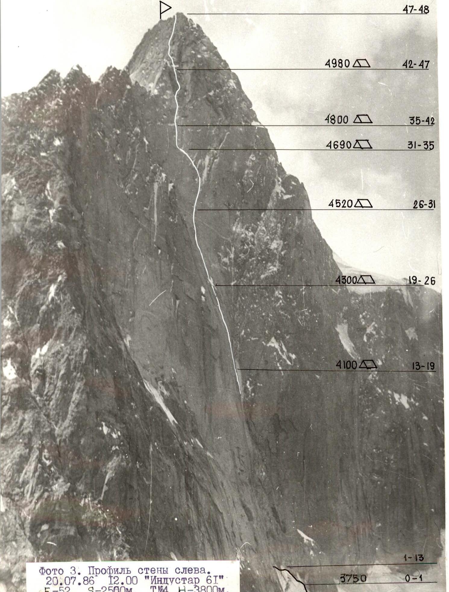
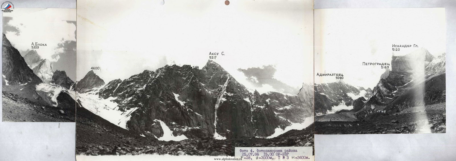
Photo 4. Panoramic photo of the area on July 25, 1986, 15:00 OF-28P F=28, S=3000 m, T № 3 H=3600 m.

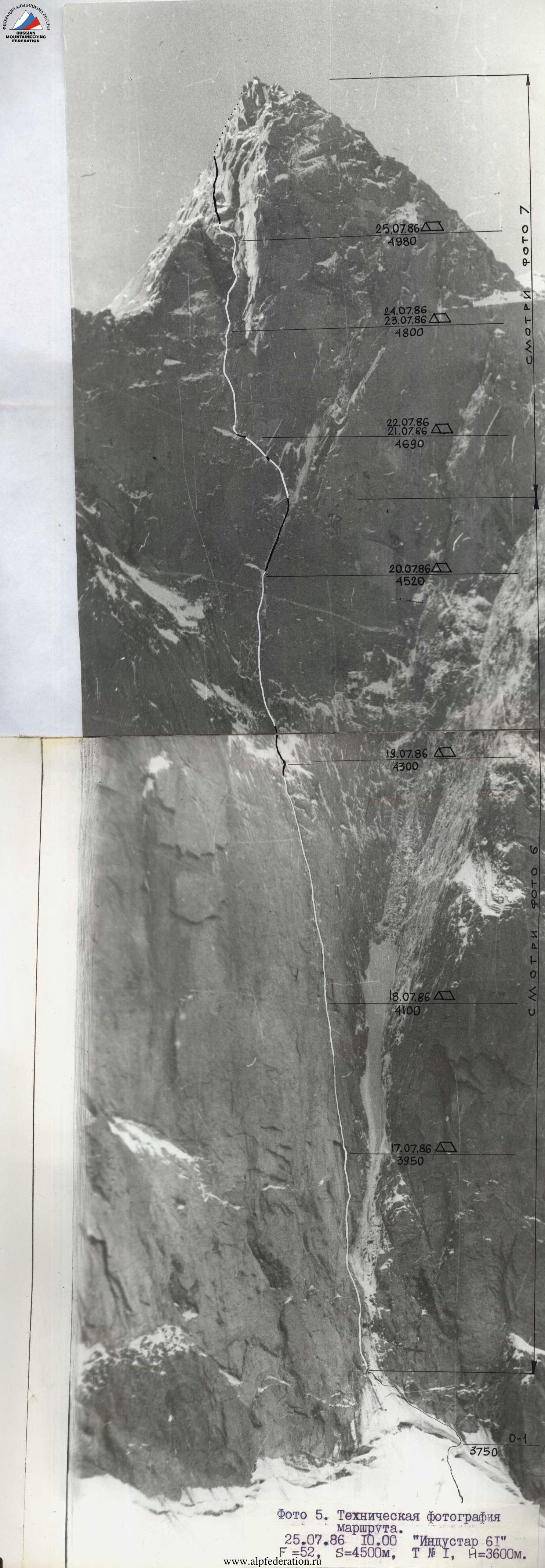
Photo 5. Technical photo of the route. July 25, 1986, 10:00 "Industar 61" F=52, S=4500 m, T № 1 H=3600 m.
Brief Overview of the Climbing Area
Peak Aksu Severnaia (5217 m) is part of the Turkestan Range in the Pamir-Alay mountain system. It is located in the upper reaches of the Aksu River, 30 km west of the Matcha mountain junction. The Aksu River, merging with the Karasu River, forms the Jetykuirik River, which flows into the Laylak River. The village of Katran is 30 km downstream from the confluence of Jetykuirik and Laylak, accessible by bus from Leninabad via Iskhana. The road extends to the confluence of Aksu and Karasu. The area around the peak is well-developed for alpinism and has become very popular in recent years due to a variety of interesting peaks and routes. Alpinists first began to explore this area seriously in 1982. In the same year, a team from Leningrad successfully ascended Peak Aksu as part of the USSR Championship. Currently, there are eight routes to the summit with a difficulty category of 5B. The ascent via the center of the North face was considered challenging both in terms of difficulty and the time required for the ascent. The peaks of the watershed range (Turkestan Range) are primarily composed of large-block granites with minimal fracturing. The northern spurs are composed of granites, limestone, and lower sections of schist, with pegmatite outcrops at the contacts. This geological structure is characterized by a limited number of holds for free climbing, a characteristic feature of routes in the area. The valley is home to several five-thousanders: Iskander (5120 m), Admiralteets (5090 m), and A. Blok (5229 m). The weather in the area is generally stable. The optimal time for climbing the wall is late June or the second half of August. More detailed information about the area can be found in the report by S. Efimov and V. Bashkirov.
Photo 6. Technical photo of the route, section R3–R29. July 25, 1986, 16:00 "Industar 61" F=52, S=2500 m, T № 5 H=3600 m.
Tactical Actions of the Team
Among the peaks of the Aksu valley, which is a branch of the Laylak valley, the most interesting and challenging route is the ascent of Aksu via the center of the North face. S. Efimov noted this in his report on the ascent of A. Blok peak in 1983. The North faces, with their harsh microclimate, are characterized by steep monolithic blocks with limited terrain, internal corners filled with ice – a combination that poses significant challenges. The team had not encountered routes like this before. They had experience climbing in the Sayan Mountains under winter conditions, but those routes were significantly less demanding in terms of length and steepness. The tactical plan was initially designed for 8 overnight stays, but the bad weather starting on July 21 significantly altered the plan. Having a necessary reserve of fuel and supplies prevented tension within the team. On the route, the team adopted a movement scheme where the first climber ascended without a backpack, using double rope protection. Each subsequent climber also worked with double ropes: one rope served as "rappel ropes," and the other as top-rope protection. This scheme ensured not only a high pace of movement but also sufficient reliability, a method the team had employed on complex routes for several years. Since all team members had equal capabilities, a different pair led each day. The order of the pairs was as follows:
- Karataev V. — Zhila A.
- Bystrov S. — Kirillov S.
- Tokarev A. — Donskoy K.
- Popov V. — Zhila A. This order remained unchanged throughout the ascent, with only the lead climbers within each pair switching. The tactical plan included processing the route beyond the planned overnight stop. This was often achieved, except on days with bad weather. Overnight stops were planned under the protection of overhanging cornices and protruding relief features, and this was strictly adhered to. The team had two platforms for five and two people, respectively. During bad weather, everyone could rest on a single platform. The nutrition regimen was standard:
- Hot meals in the morning and evening
- Individual snacks during the day The successful completion of the ascent, even under adverse weather conditions, confirmed the correctness of the chosen tactics and the selection of supplies and equipment. Communication with observers was maintained via a "Karat" radio station three times a day.
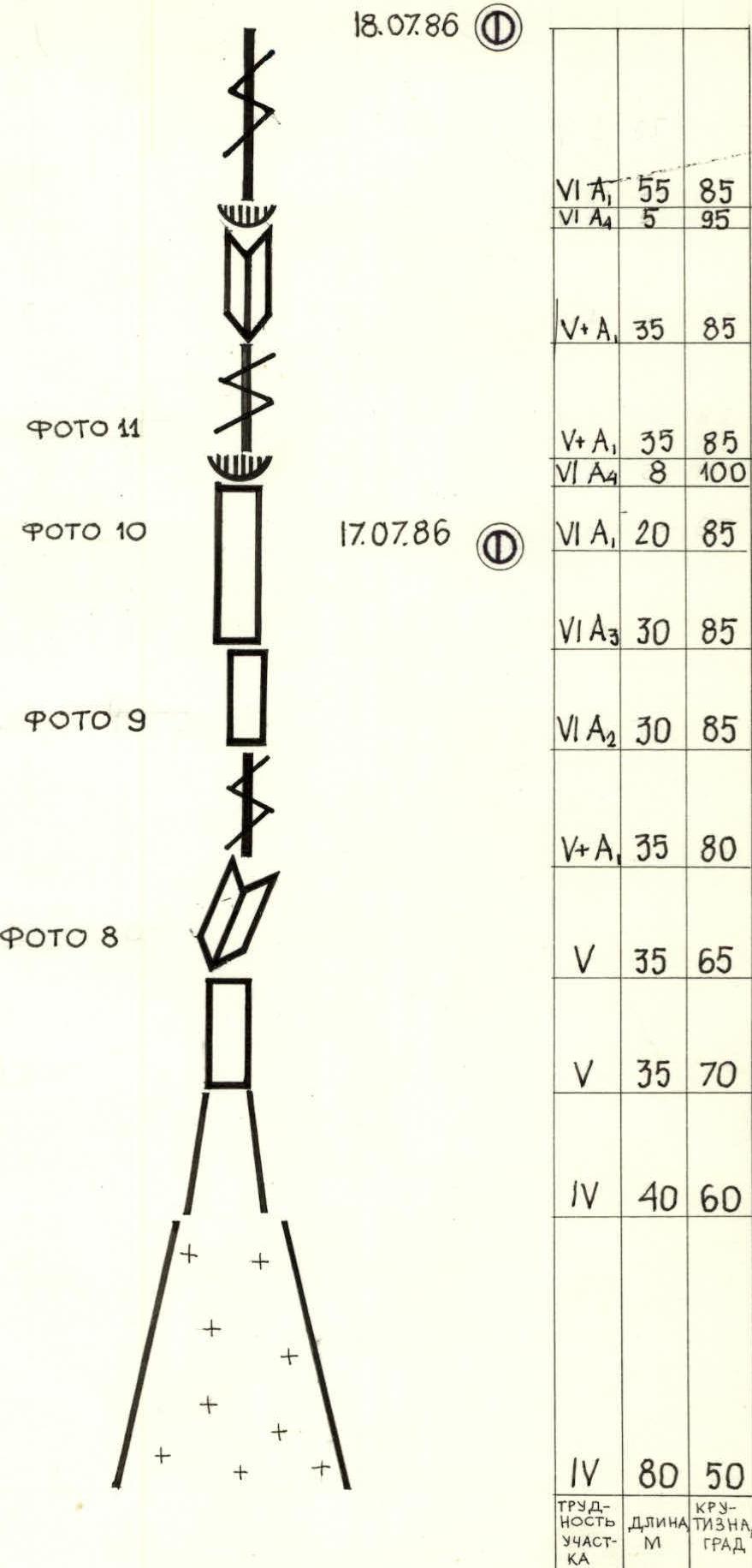
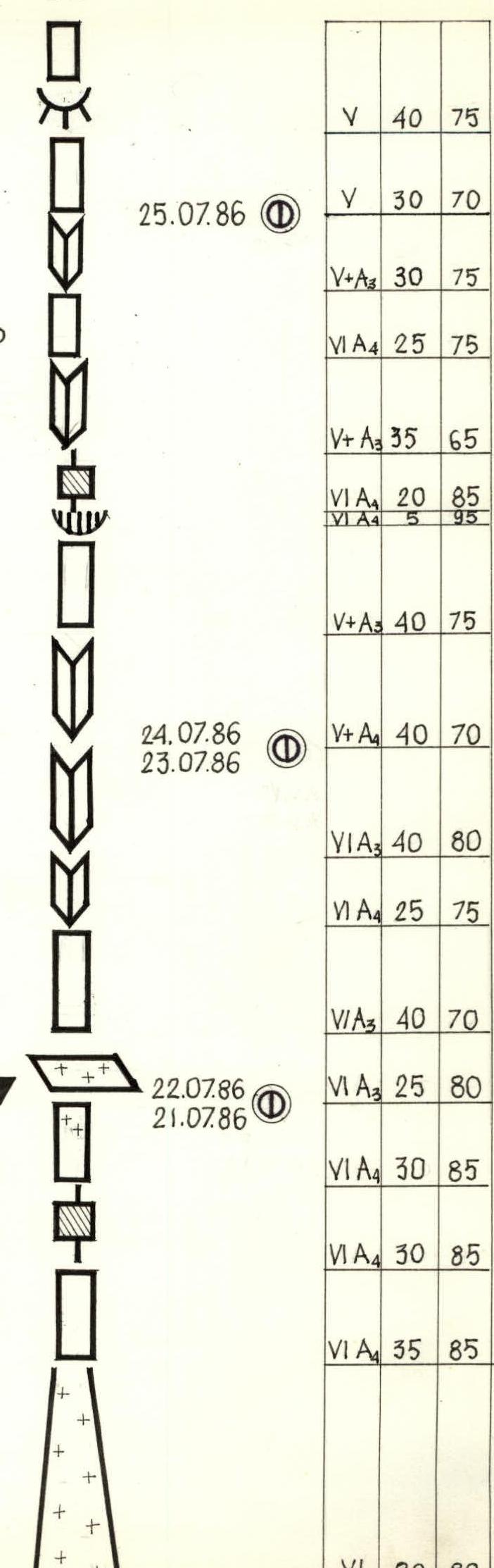
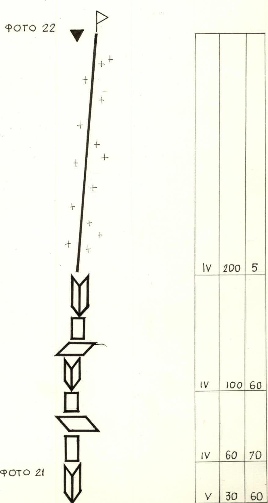
Route Diagram in Symbols. Scale 1:2000
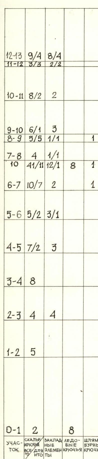
Table of Pitons Used by Sections
| Section | Rock pitons | Nuts | Ice screws | Bolts |
|---|---|---|---|---|
| R0–R1 | 2 | 8 | ||
| R1–R2 | 5 | |||
| R2–R3 | 4 | 4 | ||
| R3–R4 | 8 | |||
| R4–R5 | 7/2 | 3 | ||
| R5–R6 | 5/2 | 3/1 | ||
| R6–R7 | 10/7 | 2 | 1 | |
| R7–R8 | 4 | 1/1 | 8 | 1 |
| Total R7–R10 | 41/11 | 12/1 | 8 | 1 |
| R8–R9 | 5/5 | 1/1 | 1 | |
| R9–R10 | 6/1 | 3 | 1 | |
| R10–R11 | 8/2 | 2 | ||
| R11–R12 | 3/3 | 2/2 | ||
| R12–R13 | 9/4 | 8/4 | ||
| R13–R14 | 14/3 | 5/2 | ||
| Total R11–R14 | 49/18 | 23/10 | 1 | |
| R14–R15 | 5 | 2 | ||
| R15–R16 | 5/2 | 2/1 | ||
| R16–R17 | 7/5 | 3 | ||
| R17–R18 | 7 | 2 | ||
| R18–R19 | 3 | |||
| R19–R20 | 10 | 1 | 1 | |
| R20–R21 | 6 | 3 | ||
| R21–R22 | 6 | 4 | ||
| R22–R23 | 4/1 | 2/1 | 1 | |
| Total R19–R22 | 49/7 | 17/1 | 1 | |
| R23–R24 | 4/2 | 2/2 | ||
| R24–R25 | 4/1 | 2 | ||
| R25–R26 | 6 | 2/2 | ||
| R26–R27 | 6/4 | 2/2 | 2/1 | 1 |
| R27–R28 | 3 | 1 | 6 | 1 |
| Total R27–R28 | 27/8 | 11/7 | 8/1 | 2 |
| R28–R29 | 8/8 | 6/6 | ||
| R29–R30 | 20/20 | 3/2 | 2/1 | |
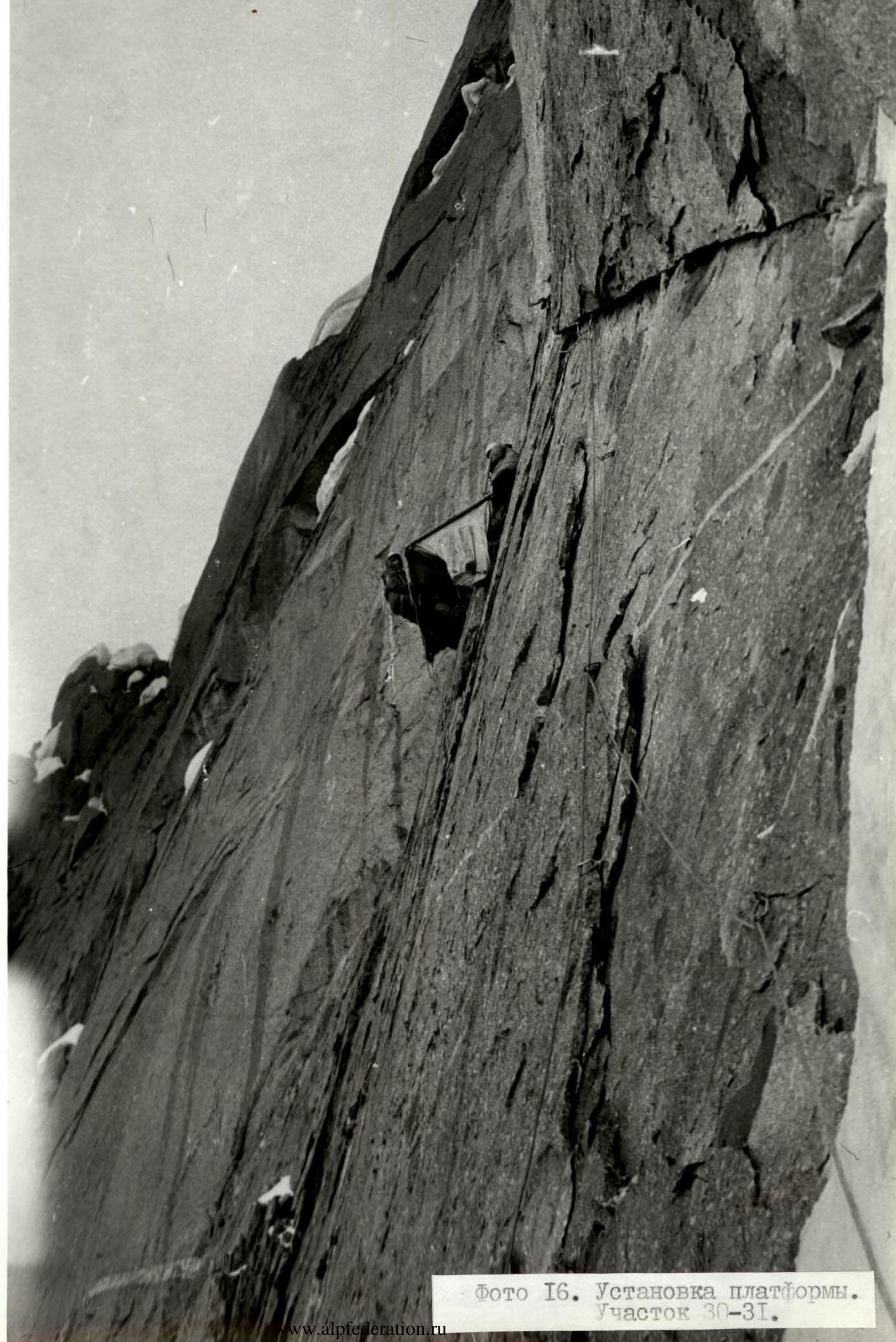
| R30–R31 | 15/13 | 4/4 | ||
| R31–R32 | 6/4 | 2/2 | 1 | |
| Total R29–R31 | 49/45 | 15/14 | 3/1 | |
| R32–R33 | 11/7 | 1/1 | 1 | 1 |
| R33–R34 | 12/12 | 3/3 | 1 | |
| R34–R35 | 13/10 | 6/2 | ||
| Total R34–R35 | 25/22 | 9/5 | 1 | |
| R35–R36 | 7/6 | 4/4 | 1 | |
| R36–R37 | 6/4 | 4/4 | 1 | |
| R37–R38 | 2/2 | 3/3 | ||
| R38–R39 | 6/6 | 10/10 | ||
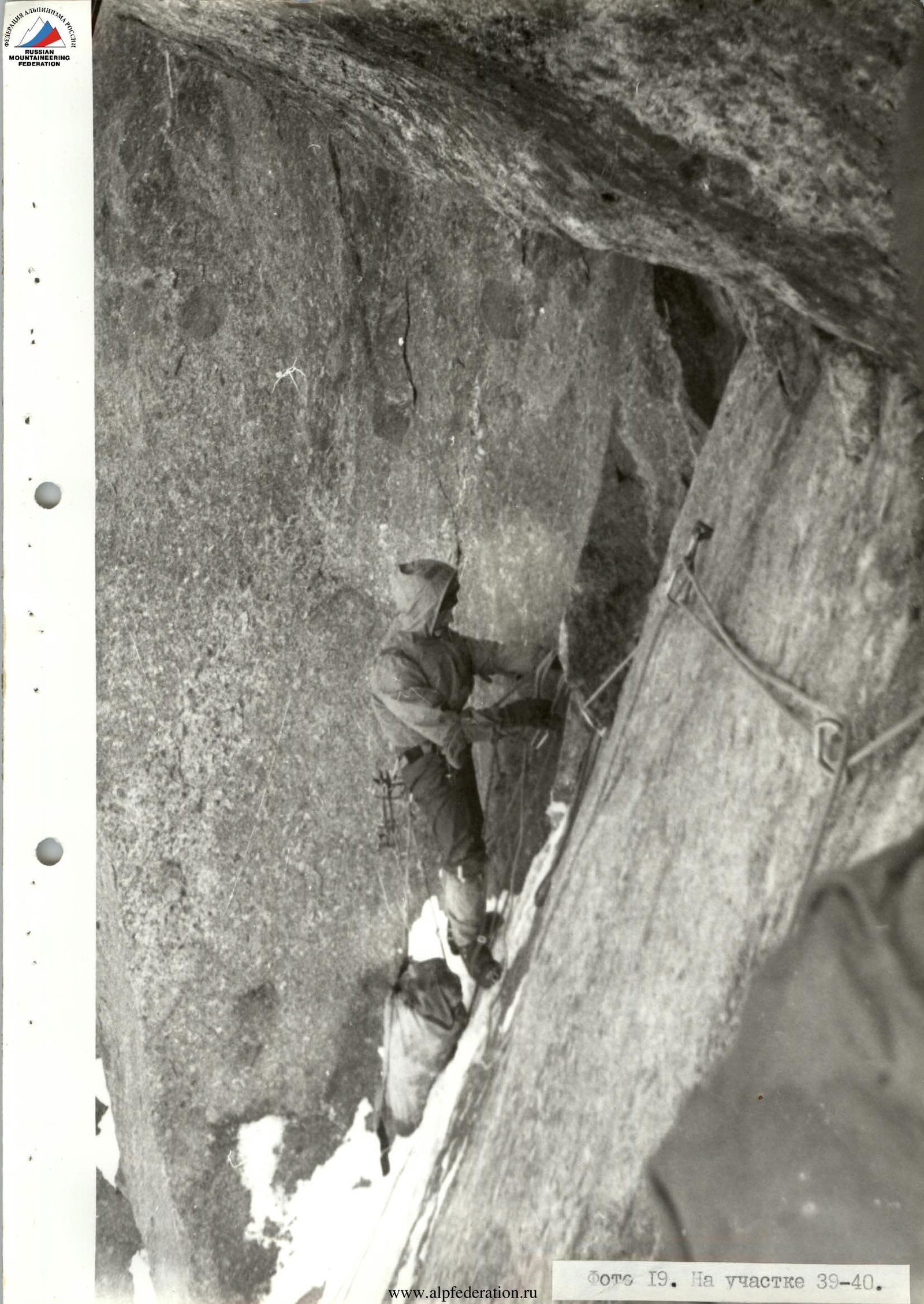
| R39–R40 | 10/6 | 5/5 | 1 | 1 |
| Total R39–R40 | 21/18 | 21/21 | 2 | |
| R40–R41 | 2/1 | 10/10 | 1/1 | |
| R41–R42 | 3 | 3 | 2/1 | |
| R42–R43 | 8 | |||
| R43–R44 | 8 | 2 | 1 | |
| R44–R45 | 4 | 3 | ||
| R45–R46 | 8 | 5 | ||
| R46–R47 | 12 | 10 | ||
| R47–R48 | 5 | 8 |
Table of Difficulty, Length, and Slope of Sections
| Section | Difficulty | Length (m) | Slope (°) |
|---|---|---|---|
| R0–R1 | IV | 80 | 50 |
| R1–R2 | IV | 40 | 60 |
| R2–R3 | V | 35 | 70 |
| R3–R4 | V | 35 | 65 |
| R4–R5 | V+A | 35 | 80 |
| R5–R6 | VI A2 | 30 | 85 |
| R6–R7 | VI A3 | 30 | 85 |
| R7–R8 | VI A1 | 20 | 85 |
| R8–R9 | V+A4 | 8 | 100 |
| R9–R10 | V+A1 | 35 | 85 |
| R10–R11 | VI A4 | 5 | 95 |
| R11–R12 | VI A4 | 55 | 85 |
| R12–R13 | VI A4 | 55 | 85 |
| R13–R14 | V+A2 | 75 | 80 |
| R14–R15 | V+ | 35 | 85 |
| R15–R16 | V+A1 | 30 | 75 |
| R16–R17 | V+A2 | 35 | 70 |
| R17–R18 | V | 40 | 65 |
| R18–R19 | IV | 25 | 60 |
| R19–R20 | IV | 80 | 50 |
| R20–R21 | V | 40 | 60 |
| R21–R22 | V | 40 | 70 |
| R22–R23 | V+A1 | 30 | 80 |
| R23–R24 | VI A3 | 10 | 100 |
| R24–R25 | VI A1 | 30 | 85 |
| R25–R26 | VI A1 | 40 | 80 |
| R26–R27 | VI A4 | 20 | 95 |
| R27–R28 | VI | 80 | 80 |
| R28–R29 | VI A4 | 35 | 85 |
| R29–R30 | VI A4 | 30 | 85 |
| R30–R31 | VI A4 | 30 | 85 |
| R31–R32 | VI A3 | 25 | 80 |
| R32–R33 | VI A3 | 40 | 70 |
| R33–R34 | VI A4 | 25 | 75 |
| R34–R35 | VI A3 | 40 | 80 |
| R35–R36 | V+A4 | 40 | 70 |
| R36–R37 | V+A3 | 40 | 75 |
| R37–R38 | VI A4 | 5 | 95 |
| R38–R39 | VI A4 | 20 | 85 |
| R39–R40 | V+A3 | 35 | 65 |
| R40–R41 | VI A4 | 25 | 75 |
| R41–R42 | V+A3 | 30 | 75 |
| R42–R43 | V | 30 | 70 |
| R43–R44 | V | 40 | 75 |
| R44–R45 | V | 30 | 60 |
| R45–R46 | IV | 60 | 70 |
| R46–R47 | IV | 100 | 60 |
| R47–R48 | IV | 200 | 5 |
Total
| Climbing Hours | Rock Pitons | Nuts | Ice Screws | Bolts |
|---|---|---|---|---|
| 98 | 332 | 150 | 24 | 10 |
| 147 | 70 | 2 | 2 |
Description of the Route by Sections
Section R0–R1: Crossing the bergschrund on the right side. Moving along the top of the bergschrund to the left. Approaching the base of the ice chute.
R1–R2: Ascending the right side of the chute along the rocks.
R2–R3: Crossing the chute to reach the left side.
R3–R4: Ascending the left side of the chute. Free climbing.
R4–R5: Moving towards a vertical cleft. To the right is a reddish overhanging cornice.
R5–R6: Challenging climb up vertical slabs using artificial aids.
R6–R8: Ascending towards a cornice, difficult climbing with artificial aids.
R8–R9: The cornice is traversed directly through a small cleft. Protection via a bolt.
R9–R12: Ascending a small cleft with limited holds. The cornice is traversed using artificial aids.
R12–R13: Slightly rightward along the rock wall under a small cornice.
R13–R14: Chimney-gully. Smooth walls.
R14–R15: Steep slab with a cleft.
R15–R20: Gradual flattening. The right plane of the cleft is slightly higher than the left. Ice is present at the bottom. Loose rocks at the end of the section.
R20–R22: Relatively gentle section. Slabs and cracks are ice-covered. Crampons are used. Protection via pitons and nuts.
R22–R23: The steepness of the wall increases. Slabs with limited holds. Artificial aids used.
R23–R24: Cornice formed by an outcrop. "Friends" are placed under the outcrop. "Cliffhangers" and nuts are used.
R24–R26: Slabs with minimal fracturing. Limited holds.
R26–R27: The cornice is traversed from left to right. Ice-covered. Ice screws are used. Leads to the start of an ice gully.
R27–R28: Ice gully with monolithic walls. Protection via ice screws and nuts. Crampons and ice axe are used.
R28–R31: Ascending through broken rocks and slabs. Direction follows an arc from right to left. Use of artificial aids and "cliffhangers."
R31–R33: Ascending relatively gentle slabs, veering left towards an internal corner. Caution due to loose slabs. Protection via bolts.
R33–R36: Ascending an internal corner filled with ice, using crampons. Ice screws and universal pitons are used for protection.
R36–R42: Series of vertical slabs alternating with internal corners. A cornice is present in the middle. The slab beyond the cornice is traversed using skyhooks.
R42–R45: Ascending "ram's foreheads" alternating with vertical walls. Direction is leftward and upward. Protection using nuts. Alternating between crampons and galoshes.
R45–R47: Rock walls with numerous holds alternate with internal corners, intersected by inclined ledges. Free climbing towards the summit ridge.
R47–R48: Ascending a sharp, narrow ridge to the summit. Piton protection.
Photo 8. On section R3–R4.

Photo 10. On section R7–R8.
Photo 13. On section R24–R25.
Photo 14. On section R26–R27.
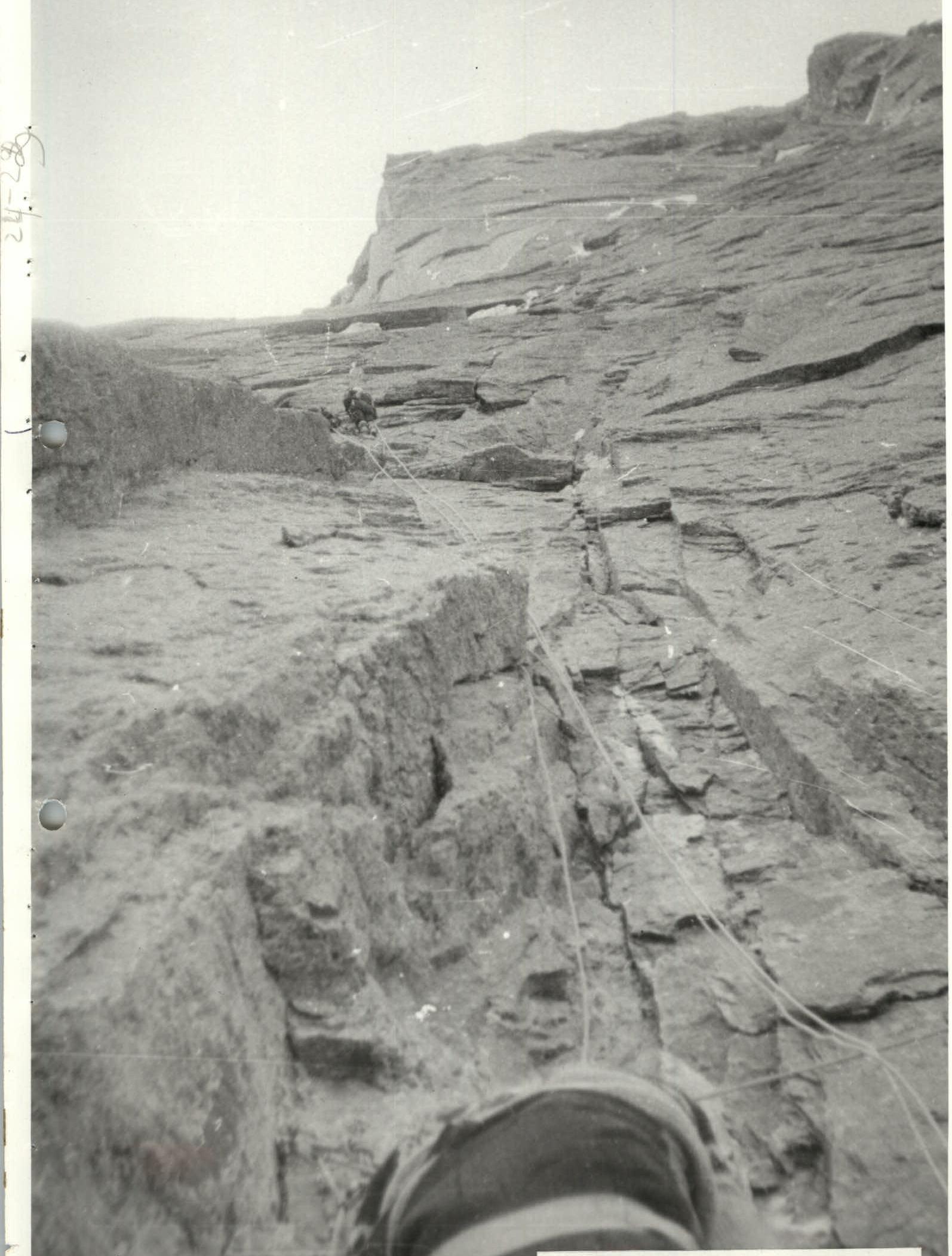
Photo 16. Platform installation. Section R30–R31.
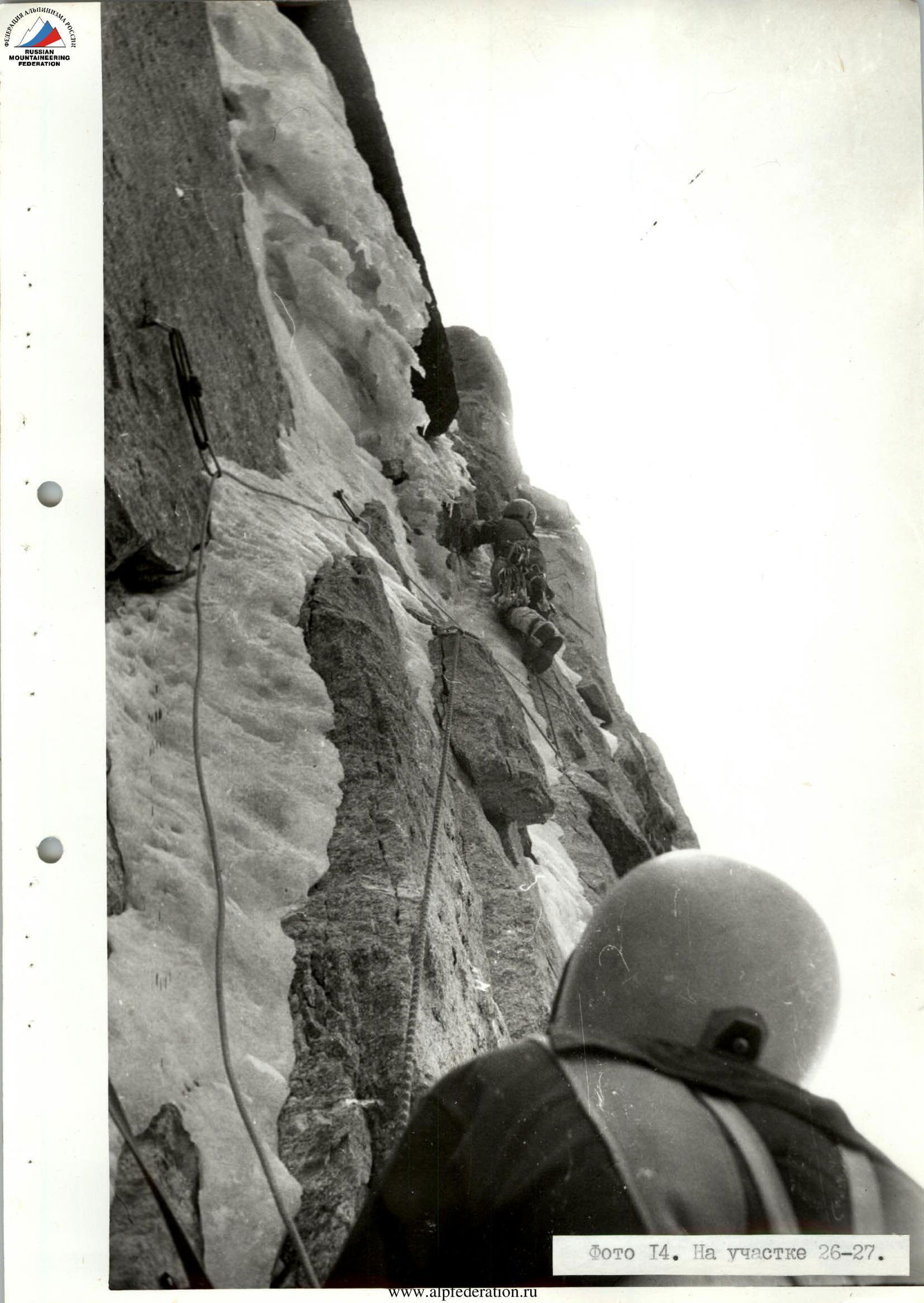
Photo 18. On section R35–R36.
Photo 19. On section R39–R40.