Ak-su (N) 5217 m — cold angle of northern wall (first ascent), Pamir-Alai, Turkestan ridge, Lyaylyak gorge 5.4.2.6
Ascent Passport
-
Ascent class — technical
-
Ascent area — Pamir-Alai, Turkestan ridge, Lyaylyak gorge
-
Peak Ak-su (N) 5217 m — cold angle of N wall (first ascent)
-
Category of difficulty — 6 (proposed)
-
Height difference — 1460 m.
Length — 1840 m. Length of sections of 5–6 difficulty category — 1520 m. Average steepness of the route — 61° (3750–5217 m), wall — 67° (3750–4850 m)
-
Hooks left on the route:
rock — 7 chocks — 2
-
Number of walking hours/days — 65/8
-
Overnights: 1–6 in platform-tent
7–8 in ridge tent
-
Leader — Antonov Andrey Yurievich, Master of Sports of Russia International Class
Participants — Tukhvatullin Ilyas Hamidovich, Master of Sports
— Shabalin Pavel Eduardovich, Master of Sports of Russia International Class
-
Coach — Shabalin Pavel Eduardovich, Master of Sports of Russia International Class
-
Entry to the route — July 29, 1997
Summit — August 5, 1997 Return — August 6, 1997
-
Team of "RODINA" sports club of Kirov regional sports committee
Tactical actions of the team
The tactical plan of the ascent provided for passing the wall in 5 days, however, the weather made its adjustments. The team spent 8 days and 65 walking hours to complete the route. The movement scheme of the trio on the big wall is traditional.
- The first climber works on a double rope
- The second goes along the fixed ropes with top rope protection and carries two backpacks (one — American style)
- The third moves autonomously on double fixed ropes with a backpack and a platform in assembled form
From the technical equipment, we highlight the UIAA-tested sets of cams CAMALOT & TRANGO, ice axes in special winter design, nitrided, allowing to be used equally successfully on ice and on rocks, hook-nut, ring ladders, skyhooks and a set of bolts, repeatedly tested on previous ascents, as well as a platform-tent. There were no falls on the route. Belaying was done through a "figure eight", slings, and PETZL extenders. Belay stations were organized at least on three points, balanced by a loop. The first climber usually started working on the route at 9:00 AM. Earlier exits were impractical due to very low morning temperatures. It is also very cold during the day. During the entire stay on the wall, the sun never lit the route. This determines the winter character of the ice in the cold corner and creates problems both for movement and for organizing belays. The nutrition was standard for wall climbing:
- In the morning and evening — hot, not requiring cooking: noodles, mashed potatoes with meat, tea, carbohydrates
- During the day — individual nutrition
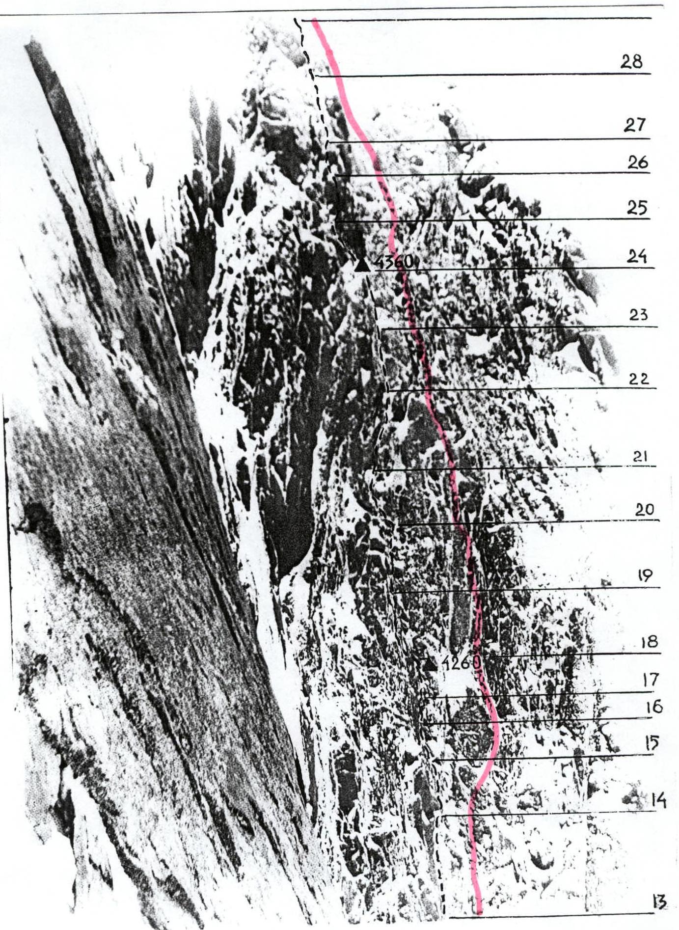
Among the features of the route, we note very strong icing of its rocky part, which starts almost from the end of Moshnikov's ice river and ends on the ridge. It is a kilometer-long section of "ram's foreheads" (23 ropes) with a steepness of 70°, covered in places with ice crusts. The sun does not appear here even in summer, so the ice is winter, overcooled. When the first climber moves, the crust crumbles and one has to work with an ice axe on dull cracks or just ledges, recesses. Unlike a skyhook, an ice axe does not provide such stability on rocky terrain, so it is often impossible to hammer in a bolt, and other points cannot be made in principle. In the West, climbing on ice axes is classified as ITO (man-made equipment). Working on unreliable ITO within 15–25 m from a normal belay point is considered artificial climbing A3–A4. Therefore, in the technical description of the route and the UIAA scheme, we evaluate the difficulty of individual sections in this way, despite the minimal use of hooks, chocks, etc. as ITO.
| rock | chock | bolt | ice | UIAA SCHEME | № sect. | length, m | steep., ° | diff. cat. |
|---|---|---|---|---|---|---|---|---|
| 6 | 13 | 40 | 60 | V | ||||
| 5 | 12 | 40 | 70 | V | ||||
| 4 | 11 | 40 | 65 | V | ||||
| 4 | 10 | 40 | 65 | V | ||||
| 5 | 9 | 40 | 65 | V | ||||
| 4 | 8 | 40 | 65 | V | ||||
| 4 | 7 | 45 | 60 | IV | ||||
| 5 | 6 | 50 | 65 | V | ||||
| 5/3 | 7/4 | 2 | 5 | 50 | 75 | VIA1 | ||
| 4 | 5 | 1 | 4 | 40 | 75 | V+ | ||
| 3 | 3 | 45 | 60 | IV | ||||
| 3 | 2 | 45 | 55 | IV | ||||
| 5 | 1 | 45 | 70 | V | ||||
| 2 | 1 | 4 | 27 | 40 | 75 | VIA1 | ||
| :----: | :----: | :---: | :--: | :---------: | :-----: | :-------: | :-------: | :--------: |
| 1 | 2 | 4 | 26 | 40 | 70 | VIA1 | ||
| 2 | 2 | 3 | 25 | 40 | 75 | VIA1 | ||
| 1 | 2 | 4 | 24 | 45 | 80 | VIA1 | ||
| 2/1 | 3/1 | 2 | 23 | 50 | 85 | VIA3+ | ||
| 5/4 | 6/6 | 2/2 | 22 | 45 | 80 | VIA3 | ||
| 6/6 | 5/5 | 2/2 | 3/3 | 21 | 45 | 80 | VIA4– | |
| 3/2 | 2/1 | 3 | 20 | 40 | 75 | VIA2 | ||
| 2/2 | 4/2 | 3 | 19 | 40 | 70 | VIA1 | ||
| 3/2 | 3/1 | 2 | 18 | 40 | 75 | VIA1 | ||
| 3 | 3 | 17 | 40 | 80 | VI | |||
| 2/2 | 2/2 | 2 | 16 | 40 | 85 | VIA3 | ||
| 2 | 2 | 4 | 15 | 40 | 75 | VI | ||
| 1 | 1 | 4 | 14 | 40 | 75 | V+ | ||
| 3 | 39 | 200 | 20 | III | ||||
| :----: | :----: | :---: | :--: | :---------: | :-----: | :-------: | :-------: | :--------: |
| 14/5 | 28/9 | 38 | 300 | 45 | III–VI | |||
| 3 | 37 | 55 | 55 | III | ||||
| 12/9 | 13/8 | 2/2 | 36 | 50 | 90 | VIA4– | ||
| 3 | 35 | 40 | 60 | IV | ||||
| 3 | 34 | 40 | 60 | IV | ||||
| 1 | 4 | 3 | 33 | 45 | 70 | VI | ||
| 6/5 | 2/2 | 2/1 | 2/1 | 32 | 40 | 80 | VIA3 | |
| 4/3 | 3/3 | 3 | 31 | 45 | 75 | VIA2 | ||
| 2 | 2 | 5 | 30 | 40 | 80 | VIA2 | ||
| 7 | 29 | 40 | 90 | VIA3– | ||||
| 5 | 28 | 40 | 80 | VI |
Description of the route by sections
R1–R4 The route begins with passing the bergschrund, then two ropes up to the base of the rocky belt.
R4–R6 Two ropes of destroyed rocks, in the upper part "ram's foreheads", covered with ice.
R7–R14 Moshnikov's ice river is passed along the left rocks. Stations in niches-shelters. Overnight stay at the end of the river.
R14–R16 A narrow ice gorge leads to the icy rocks of the cold angle.
R16–R21 Implicitly expressed corners alternate with complex walls. Climbing in crampons with ice axes on rocks, sometimes jumping on ITO. Difficulties in organizing belays. Overnight stay at the end of the section.
R21–R25 Very difficult ropes, the passage is complicated by bad weather. The problems are the same as the previous day. The relief is the same. Safe overnight stay, but unsuccessful — it is snowing. There are no other places — we are in the corner.
R25–R31 Ice rivulet with an overhanging left rocky roof. Left ice axe works on ice crust, right — on rock. At the top of the section, a very steep ice forehead on a cornice. The overnight stay is again snowed in.
R31–R34 Here the ice lies not on a monolith, but in destroyed corners-chimneys. At the end of the section, a complex traverse to the left onto a good ice river.
R34–R36 On easy ice, we exit to the top of Moshnikov's collapse from the right side. Here the routes converge.
R36–R37 Straight up — very tense climbing. Cracks are either blind or between living blocks. Problems in organizing belays.
R37–R38 A large snow-ice shelf leads to the last rocky wall, leading to the ridge.
R38–R39 A complex, with "gendarmes" ridge ends with a rappel loop.
R39–R40 From the rappel loop to the right along the ridge towards the summit. The "gendarme" is bypassed on the left, then to the saddle and to the right side of the ridge. On snow and easy rocks to the summit.
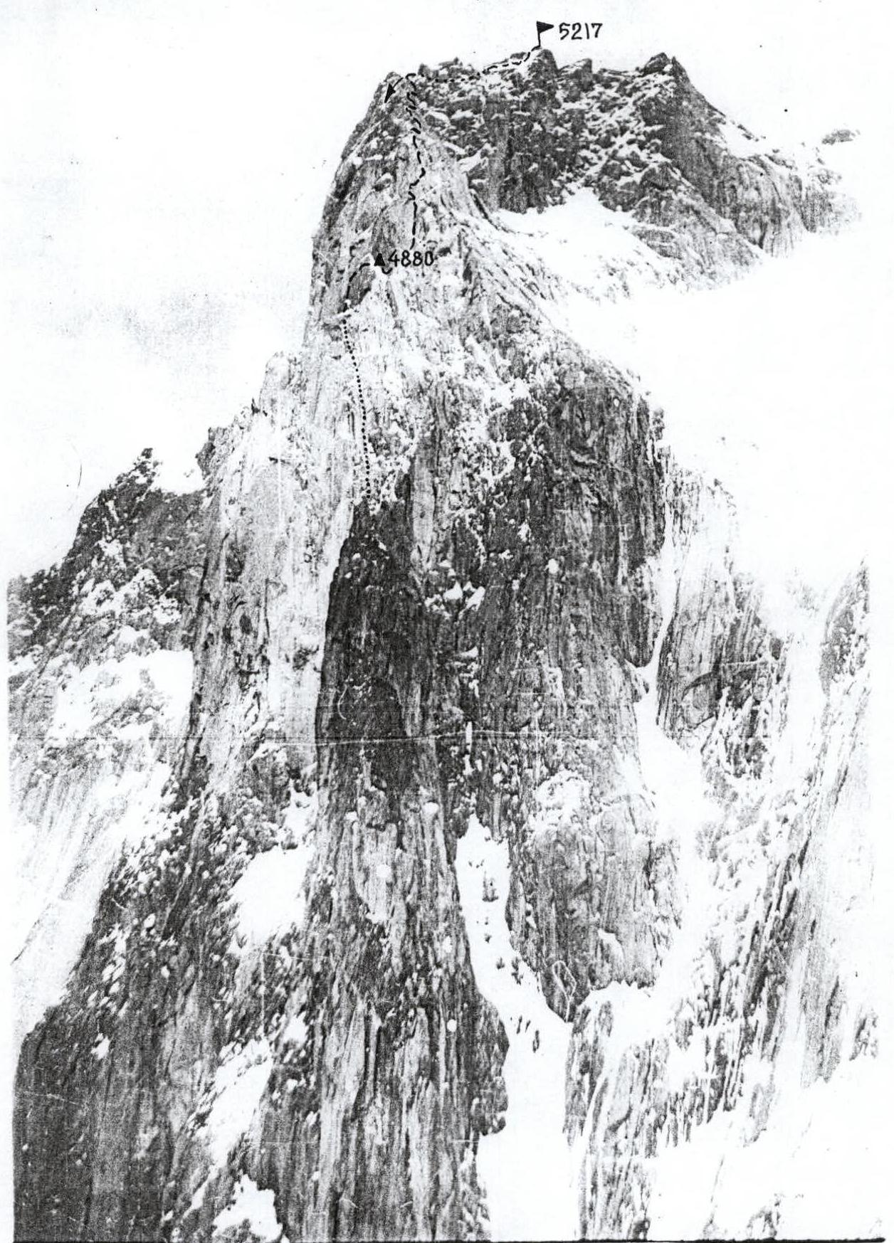
PROFILE OF THE WALL ON THE RIGHT. Taken in July 1991 during the ascent to p. "Admiralteets" "along the pillar" as part of the Russian Championship. Camera — "Smena", shooting point № 2. Distance — 2 km. Height — 4520 m.
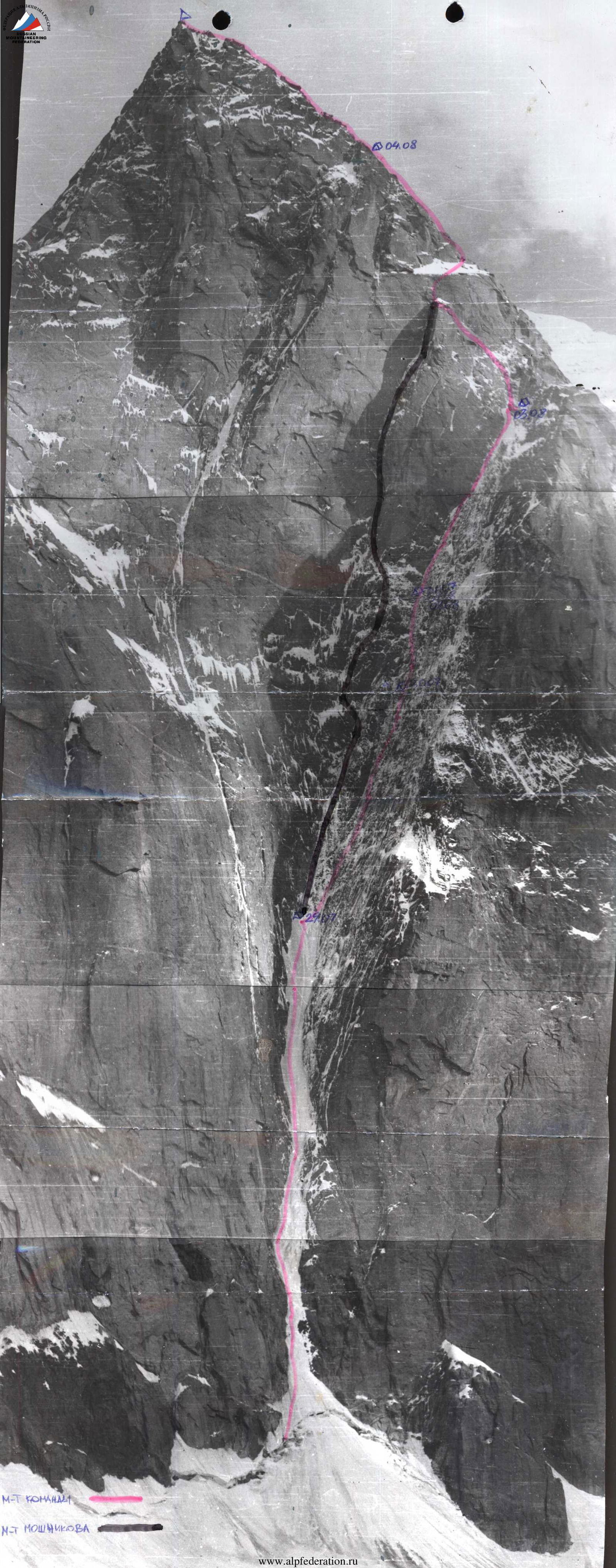
TECHNICAL PHOTOGRAPHY OF THE MIDDLE PART OF THE ROUTE. Taken on August 5, 1993 from the "big ice field" on the route of Popov — Babanov by V.P. Shooting point № 5. Camera "Smena".