ASCENT REPORT
- Ascent class — technical
- Ascent area — Pamir-Alay, Turkestan Range
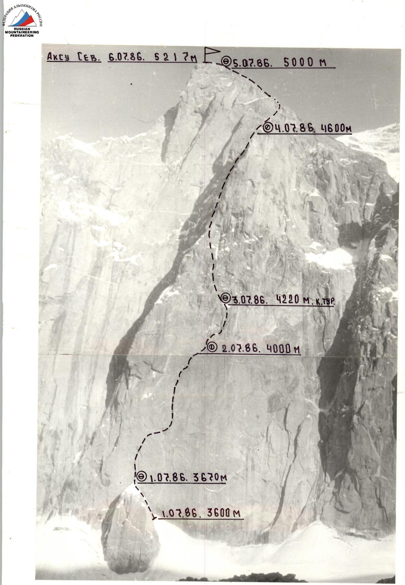
- Peak — AkSu North (5217 m) via the North face
- Proposed category of difficulty — 6 (2nd ascent)
- Height difference — 1617 m
- of which:
- wall section — 750 m
- Length — 2195 m
- Length of sections of 5–6 cat. diff. — 1395 m
- of which 6 cat. diff. — 575 m (3670–3720, 3800–3920, 3955–4160, 4310–4350, 4840–4900, 4990–5025)
- Height difference:
- wall section — 73° (750 m), including 540 m — 80°
- Edge — 57° (305 m)
- West ridge — 50° (400 m)
- of which:
- Pitons hammered in:
rock chocks ice bolt 146 96 18 6+7* 11 14 6 1+17* - Team's travel hours — 63.5 (6 days to ascend)
- Overnights:
- lying in a tent, on snow
- sitting and in hammocks, separate
- lying in a tent, on snow
- sitting in a tent
- lying in a tent, on snow
- Team LOS DSO "Burevestnik"-2
- Leader — Alexey V. Gusyaev — MS
- Participants:
- Vyacheslav I. Glushko — MS
- Yuri D. Bushmanov — CMS
- Vadim V. Zakharov — CMS
- Oleg S. Klonin — CMS
- Participants:
- Team coach — MS USSR Vyacheslav I. Glushko
- Departure to the route — July 1, 1986
- Summit reached — July 6, 1986
- Return — July 7, 1986
| Photo | — 2 |
|---|---|
| Date taken | — July 1, 1986 г. |
| Lens | — Industar-52 |
Distance — 1.5 km Height taken — 4000 m Shot number — 2
Troschinenko's route (1982) to the summit of AkSu North via the North face 6B cat. diff., completed by the team LOS DSO "Burevestnik"-2 from July 1 to 7, 1986 (2nd ascent).
| pitons | route diagram | |||||||
|---|---|---|---|---|---|---|---|---|
| r. | ch. | ice | b. | in UIAA symbols | № | dist., m | steep., deg. | cat. diff. |
| R14 | ||||||||
| 2 | 2 | 0/2 | 2 | (July 3, 1986 10:00) | R13 | 45 | 70 | 5 |
| 2 | 3 | – | 1/4* | (processed until 20:00) | R12 | 30 | 90 | 6 |
| 5 | 3 | – | – | (July 2, 1986 8:00) | R11 | 40 | 90 | 5 |
| 5 | 5 | – | 1* | R10 | 40 | 80–90 | 5 | |
| 3 | 4 | – | – | R9 | 40 | 80 | 5 | |
| 2 | 3 | 5 | – | R8 | 25 | 60 | 5 | |
| 6/1 | 1/6 | 4 | 2+1* | (July 2, 1986 14:00) | R7 | 35 | 150–60 | 6 |
| 4/2 | 3/2 | – | 1* | (processed until 20:00) | R6 | 30 | 90 | 6 |
| 4 | 5/1 | 0/4 | – | R5 | 40 | 40–90 | 5 | |
| 3 | 1 | – | – | R4 | 40 | 60 | 3 | |
| 3 | 2 | – | 1* | R3 | 40 | 70 | 5 | |
| 4/2 | 4/1 | – | – | (overnight stay July 1, 1986) (July 2, 1986 8:00) | R2 | 50 | 85 | 5 |
| 1 | via ice axe | R1 | 60 | 35 | 3 | |||
| 3 | 2 | 2 | – | (3600 m) (July 1, 1986 8:30) | R0 | 40 | 60 | 5 |
| pitons | route diagram | |||||||
|---|---|---|---|---|---|---|---|---|
| r. | ch. | ice | b. | in UIAA symbols | № | dist., m | steep., deg. | cat. diff. |
| R27 | ||||||||
| 6 | 2 | 1 | – | R26 | 40 | 45 | 5 | |
| 7 | 1 | 2 | – | R25 | 40 | 55 | 5 | |
| 2 | via ledges | R24 | 40 | 60 | 5 | |||
| 2 | 3 | ledges | R23 | 40 | 60 | 5 | ||
| 2 | 1 | ledges | R22 | 40 | 45 | 5– | ||
| 3 | 1 | – | – | R21 | 40 | 45 | 4 | |
| 3 | – | – | – | R20 | 40 | 45 | 4 | |
| 4/2 | 4/2 | – | 0/1 | R19 | 40 | 90 | 6 | |
| 3 | – | – | – | R18 | 40 | 50 | 5+ | |
| 4 | 1 | – | – | (July 4, 1986 8:00) | R17 | 40 | 50 | 5+ |
| 1 | 4 | – | – | R16 | 40 | 60 | 5 | |
| 2/4 | 1/1 | – | 1/13* | (overnight stay July 3, 1986) (control cairn) | R15 | 60 | 90 | A4 |
| 6 | 4 | 2 | 2* | R14 | 400 | 85 | 6 |
| pitons | route diagram | |||||||
|---|---|---|---|---|---|---|---|---|
| r. | ch. | ice | b. | in UIAA symbols | № | dist., m | steep., deg. | cat. diff. |
| R39 | ||||||||
| 3 | 3 | ledges | R38 | 40 | 80 | 5+ | ||
| 1 | – | ledges | R37 | 60 | ridge | 4+ | ||
| 3 | – | ledges | R36 | 40 | 70 | 5 | ||
| 5 | 5/1 | – | – | R35 | 60 | 80 | 5 | |
| 2 | – | ledges | R34 | 40 | ridge | 5 | ||
| 3 | 2 | – | 1 | R33 | 40 | 50 | 5 | |
| 2 | 2 | ledges | R32 | 80 | 60 | 5– | ||
| – | – | ledges | (July 5, 1986 10:00) | R31 | 20 | 80 | 5 | |
| 2 | 1 | ledges | (processed until 21:00) | R30 | 40 | 60 | 5 | |
| 10 | 8 | – | – | (overnight stay July 4, 1986) (July 5, 1986 8:00) | R29 | 40 | 65 | 5 |
| 3 | 3 | – | – | R28 | 40 | 45 | 5 | |
| 5 | – | 2 | – | R27 | 40 | 45 | 4 |
| pitons | route diagram | |||||||
|---|---|---|---|---|---|---|---|---|
| r. | ch. | ice | b. | in UIAA symbols | № | dist., m | steep., deg. | cat. diff. |
| Total hammered in: | Total covered | |||||||
| 146 | 96 | 18 | 6+7* | 2195 m in 63.5 travel hours. | ||||
| 11 | 14 | 6 | 1+17* | AkSu North 5217 m | ||||
| Pitons left on the route by first ascenders | R47 | |||||||
| – | 2 | ledges | (July 6, 1986 12:00) | R46 | 200 | ridge | 3–4 | |
| 3 | – | ledges | R45 | 40 | 80 | 5 | ||
| – | – | ledges | R44 | 80 | ridge | 3 | ||
| 4 | – | ledges | R43 | 40 | 60 | 5– | ||
| – | – | ledges | R42 | 40 | 60 | 5+ | ||
| 2 | 3 | – | – | R41 | 40 | 60 | 5 | |
| 6 | 7 | – | – | (processed until 20:00) (July 6, 1986 8:00) | R40 | 40 | 80 | 6 |
| – | – | ledges | (overnight stay July 5, 1986) | R39 | 80 | 60 | 5+ |