PASSPORT
- Technical category.
- Pamir-Alay, Turkestan Ridge, Ak-Su gorge.
- Peak "Admiralteets" (5090) via the "pillar".
- Proposed 6B category of difficulty, first ascent, combined.
- Total elevation gain of the route — 1500 m.
Elevation gain of the "pillar" — 700 m. Elevation gain of the main part of the "pillar" — 560 m. Total route length — 2840 m. Length of the "pillar" — 920 m. Length of the main part of the "pillar" — 660 m. Average steepness of the "pillar" — 70°. Average steepness of the main part of the "pillar" — 77°. Length of sections with 5–6 category of difficulty — 640 m.
- Number of pitons used:
| Ice | Rock | Nuts | Bolts |
|---|---|---|---|
| 9 | 124 | 215 | 28 |
| 0 | 53 | 167 | 22 |
-
Team's total climbing hours: 130, days: 9.
-
Overnight stops on the route:
- 1 — two people in hammocks, three people half-lying;
- 2, 3, 4 — in hammocks;
- 5 — half-lying;
- 6, 7 — lying.
-
Team leader: Bashkirov V.L. Master of Sports of the USSR
Team members:
- Klineckii E.F. Candidate for Master of Sports
- Kovanovskii V.A. Candidate for Master of Sports
- Mikhailov S.V. Candidate for Master of Sports
- Rodnyanskii L.M. 1st category athlete
-
Team coach: Kavunenko V.D. Master of Sports of the USSR International Class
-
Departure to the route — July 3, 1985.
Summit — July 11, 1985. Return to the camp — July 12, 1985.
Profile on the right
Team's Tactical Actions
Route features:
- Most of the route consists of grey monolithic rocks; however, there are small sections of brown fractured rocks.
- Many internal corners and chimneys, where falling rocks will move along them.
These features determined the tactics of movement on the route, its characteristic features:
- Belay stations were set up only in places protected from falling rocks.
- When working on sections of brown rocks, all lower sections were either strictly to the side of the working climbers or reliably protected from rocks.
For precise coordination of actions between the upper and lower rope teams, the group used two "Vitalka" radios. Communication with observers and the camp was carried out using a "Karat" radio three times a day.
-
July 3, 1985. Early in the morning, the Klineckii-Rodnyanskii rope team started processing the lower ice section of the route. At 7:00, the team began their ascent. After 3 hours, Kovanovskii left the observation camp and brought additional ropes and equipment along the fixed ropes. Crossing the ice required special equipment (ice axes with tubular beaks) and significant physical effort due to the hard, lens-shaped ice. In the upper part, there were sections with frozen rock outcrops. By lunchtime, the processing of the ice section was completed, and at 14:00, the Mikhailov-Bashkirov team began working on the rocks. By 17:30, they had completed the first rope length, and then Bashkirov moved forward and processed the first brown patch by 21:30. On this section, great attention was paid to the correct and safe placement of the fixed ropes. The team descended to the observation camp in the dark. The weather was unstable throughout the day.
-
July 4, 1985. Continuation of processing. At 9:00, the Klineckii-Mikhailov rope team, after ascending via the fixed ropes, began working on the grey monolithic rocks. Fog, rain. There were very few holds, it was steep, and the movement was mostly on artificial terrain (aid climbing). The first 30 meters of the chimney were filled with ice. The use of expandable nuts (Friends) increased the speed of passage. At 14:00, the lead climber changed. Variable cloudiness. Steep monolithic slabs with no holds, movement on aid climbing along the goal (medium-sized nuts). By 18:00, the Bashkirov-Rodnyanskii rope team moved forward. By 21:00, they had advanced another 15 meters, performing extremely difficult climbing on an overhanging section. In some places, they had to use bolt hangers. The weather improved. The team descended to the observation camp in the dark.
-
July 5, 1985. Departure onto the route. Early in the morning, the group with their gear began moving along the fixed ropes. By 12:30, all ropes below bivouac 1A were removed, and unnecessary ropes were thrown down. The trio — Bashkirov, Klineckii, Mikhailov — gathered in a safe location under an overhanging slab (bivouac 1A), while the Rodnyanskii-Kovanovskii rope team continued processing the route. Having passed the overhanging slab on aid climbing and steep monolithic rocks (difficult free climbing), the team reached the second brown patch. Overcoming the dissected brown rocks required maximum caution from the team due to the presence of large loose rocks. At 17:30, the team reached the site of bivouac 1B for three people and began to set it up. A well-rested Mikhailov continued processing the route. Passing the section above bivouac 1B required caution due to loose rock "flakes" in the chimney. The weather was good throughout the day.
-
July 6, 1985. In the morning, the Mikhailov-Kovanovskii rope team began working on the grey solid rocks (bypassing an overhang on the left using free climbing, then along a crack through a smooth slab on aid climbing, and upwards along smoothed "lambs"). Rodnyanskii descended and helped the Bashkirov-Klineckii duo remove the fixed ropes and carry the load. At 14:00, the first rope team reached a snow patch (bivouac 2). By 17:00, the team had removed all fixed ropes below bivouac 2, and the Bashkirov-Rodnyanskii rope team continued processing, while the Klineckii-Kovanovskii-Mikhailov trio began setting up their bivouac in hammocks. The first rope team processed a rope length of a steep, partially overhanging crack. The weather was sunny throughout the day.
-
July 7, 1985. In the first half of the day, the Klineckii-Bashkirov rope team worked. They passed a monolithic internal corner (aid climbing, some free climbing) and 40 meters to the left and upwards along the third brown patch. Bivouac 2 is located beyond a bend from the brown patch and is therefore safe. In the second half of the day, the Mikhailov-Rodnyanskii rope team passed an internal corner (aid climbing, free climbing) and a brown overhanging section with yellow streaks (extremely difficult free climbing, some aid climbing on bolt hangers, with no good cracks).
-
July 8, 1985. In the first half of the day, the Rodnyanskii-Klineckii rope team overcame a large cornice and reached a small ledge. (Initially, difficult climbing on a slab, then aid climbing under the cornice using nuts and Friends, along the cornice using nuts, and up to the ledge — aid climbing and free climbing). In the second half of the day, Bashkirov-Kovanovskii passed another rope length along an internal corner with "lambs" (difficult aid climbing).
-
July 9, 1985. Since about 7 rope lengths were fixed above the snow patch, it made sense to move the bivouac site higher to avoid wasting much time on passing the fixed ropes. Therefore, in the first half of the day, the entire group made a transition from the snow ledge to bivouac 3. From lunch onwards, the Kovanovskii-Mikhailov rope team, alternating leads, processed more than half a rope length along an internal corner and reached under a reddish wall. The remaining trio chopped ice and frozen ground on an inclined ledge and prepared bivouac 3.
-
July 10, 1985. The Klineckii-Bashkirov rope team passed the last 1.5 rope lengths to the ridge (a narrow crack with small rises, some accumulated ice). In the evening, the group crossed the ridge, removing all fixed ropes. Bivouac lying on a large ledge on the rock side of the ridge. Warm, clear.
-
July 11, 1985. In the morning, after dropping a backpack with unnecessary equipment onto the glacier below the route, the group descended to a snow plateau (2 rappels of 20 m and 10 m). They ascended the South Ridge via the plateau and reached the summit. Rodnyanskii worked first on the ridge (difficult rope length on wet rock — overcoming a large gendarme on the left side, 1 rope length of careful climbing to the summit tower). They reached the summit in the evening. Bivouac on the descent. Good weather.
Table of sections R0–R5
| R | Ice | Rock | Nuts | Bolts | Length (m) | Steepness (°) | Category |
|---|---|---|---|---|---|---|---|
| R0 | 6/0 | 2/0 | 0/0 | 0/0 | 130 | 45 | 4 |
| R1 | 3/0 | 8/0 | 1/0 | 0/0 | 130 | 45 | 4 |
| R2 | 0/0 | 9/0 | 9/0 | 0/0 | 120 | 65 | 5 |
| R3 | 0/0 | 17/15 | 48/47 | 10/9 | 90 | 85 | 6 |
| R4 | 0/0 | 6/2 | 2/0 | 0/0 | 30 | 70 | 1 |
| R5 | 0/0 | 8/2 | 12/9 | 2/2 | 40 | 75 | 5 |
Table of sections R6–R15
| R | Ice | Rock | Nuts | Bolts | Length (m) | Steepness (°) | Category |
|---|---|---|---|---|---|---|---|
| R6 | 0/0 | 2/0 | 1/0 | 0/0 | 40 | 65 | 4 |
| R7 | 0/0 | 19/12 | 38/33 | 2/1 | 70 | 80 | 6 |
| R8 | 0/0 | 6/0 | 3/0 | 0/0 | 40 | 65 | 4 |
| R9 | 0/0 | 4/2 | 16/16 | 0/0 | 40 | 75 | 5 |
| R10 | 0/0 | 4/1 | 4/2 | 4/3 | 30 | 90 | 6 |
| R11 | 0/0 | 5/5 | 18/13 | 1/1 | 40 | 85 | 6 |
| R12 | 0/0 | 11/4 | 24/4 | 6/4 | 60 | 80 | 6 |
| R13 | 0/0 | 12/9 | 18/17 | 3/2 | 40 | 80 | 6 |
| R14 | 0/0 | 4/0 | 5/0 | 0/0 | 20 | 60 | 5 |
| R15 | 0/0 | 0/0 | 0/0 | 0/0 | 1500 | 20 | 1 |
Table of sections R16–R20
| R | Ice | Rock | Nuts | Bolts | Length (m) | Steep (°) | Category |
|---|---|---|---|---|---|---|---|
| R16 | 0/0 | 6/0 | 6/0 | 0/0 | 120 | 40 | 3 |
| R17 | 0/0 | 4/0 | 3/0 | 0/0 | 40 | 70 | 5 |
| R18 | 0/0 | 2/0 | 2/0 | 0/0 | 120 | 40 | 3 |
| R19 | 0/0 | 3/0 | 1/0 | 0/0 | 40 | 60 | 4 |
| R20 | 0/0 | 0/0 | 3/0 | 0/0 | 100 | 25 | 2 |
Brief Description of the Route
The route starts at the bergschrund, 30–40 m to the right of the smooth rocks. The bergschrund is crossed via snow bridges, presenting no difficulties.
Ascend strictly upwards on the ice under the rocks. Then, under the rocks, move left and upwards through frozen rock outcrops with small ledges (there are loose rocks) until the end of the ice.
From the upper left point of the ice:
- first, 20 m upwards on grey rocks,
- traverse left along an inclined ledge.
From the left part of the ledge, a logical crack goes upwards:
- up the crack and slightly to the right along dissected terrain until the end of the patch (bivouac 1A).
A distinctive feature — the bivouac is covered from above by a steep smooth wall with water flowing down it. To the right of the smooth wall is a grey slab with a crack going up to a small ledge under a chimney. Do not go far to the right from the bivouac.
Up the chimney filled with ice. After 30 m, on the right side of the chimney, there is a logical transition to a monolithic wall with a crack. A path is a visible route under an overhanging slab. The slab is intersected left and upwards. Up steep rocks to a small ledge under the second brown patch. From the start of the chimney to the ledge, belay stations are on the ropes.
From the ledge:
- upwards under a small brown overhang, which is bypassed on the left and upwards to bivouac 1B.
The ledge for bivouac 1B is located to the left of the route. From its right part, a chimney goes upwards under a grey cornice. Under the cornice is a convenient belay station on the ropes. The cornice is bypassed on the left; a good crack is visible in the monolithic slab, going right and upwards.
Along the crack and upwards through "lambs" (rounded rock formations), smoothed grey rocks — exit to brown rocks at a large snow patch. The rocks are wet, dissected.
On the left is a narrow (for feet) long ledge with ice in its left part. Above the ledge on the wall, hammocks can be hung.
From the right part of the narrow ledge:
- upwards into a crack,
- up the crack,
- near the "nose" located next to the crack — move right into an internal corner,
- along the corner under an overhang,
- move left onto an inclined ledge.
From the ledge:
- left, through bivouac 3 — traverse to the third brown patch.
A brown overhang with yellow streaks and a path to it are visible. Along the patch:
- under the overhang with streaks,
- left and upwards through the overhang to grey rocks under a large grey cornice.
On the left is a smooth convex slab. If you ascend 10–15 m, a crack for nuts is visible on the slab, leading to the left part of the cornice.
Under the cornice, then left and upwards under it to a ledge. From the ledge, it goes upwards under a yellow wall and further left and upwards — a system of internal corners with local overhangs; individual "flakes" are encountered. In some places, cracks in the corners are blind; there is ice in the upper part.
20 m before the ridge — move to a non-steep monolithic slab with good, solid holds.
From the ridge — 15 m down to a large ledge (bivouac 4).
From the bivouac:
- down simple rocks towards the South Ridge onto a plateau (2 sports rappels — 10 m and 20 m),
- along the plateau to the saddle of the South Ridge — a long, easy ascent,
- from the saddle along the ridge.
A large gendarme is bypassed on the left side; the summit tower is climbed on the right. Then down a couloir to the summit.
Descent:
- along the South Ridge to the saddle,
- from the saddle down into the Kara-Su gorge.
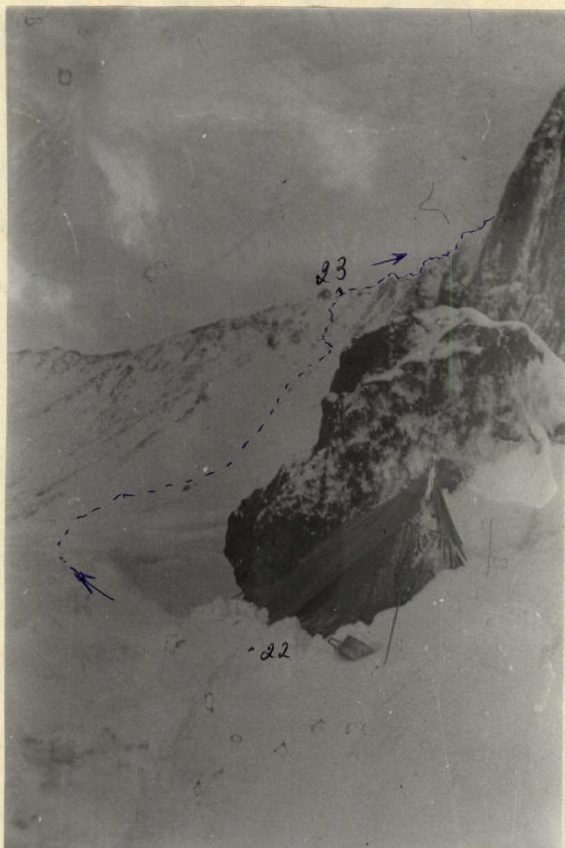
Photo #10. Section R22–R23. Third bivouac. Tent under snow after a night of bad weather.
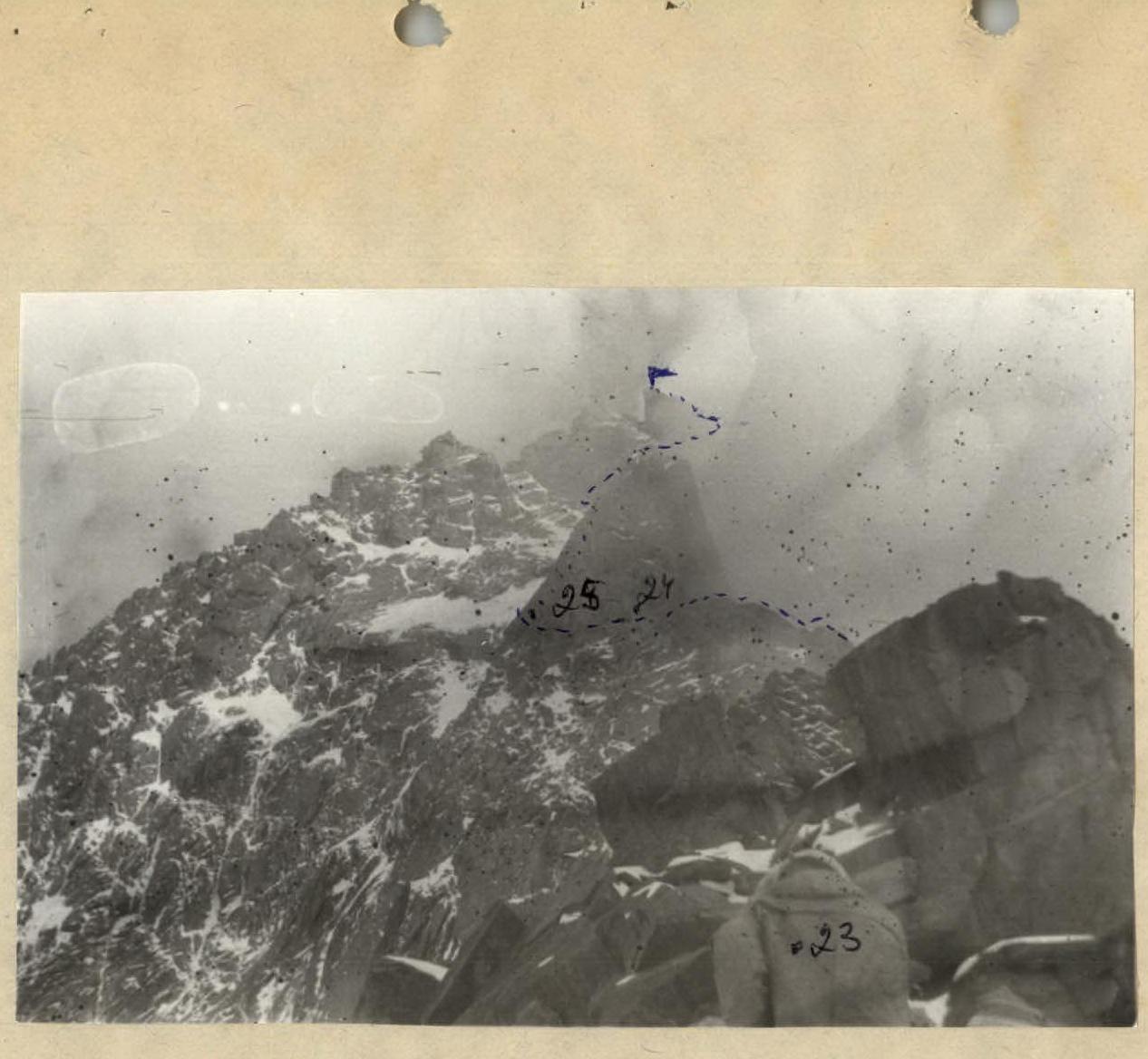
Photo #11. Sections R23–R25. Summit ridge. The gendarme is clearly visible.