Alpinist camp "Alay" 1983.
Class of technical ascents.
Report
on the ascent to the summit 5090 m (peak Admiralteets) via the North-Eastern buttress of the Eastern ridge (first ascent). Team of MGS DSO "Zenit". Moscow city council DSO "Zenit": Moscow A-40, p.o. box 545, phone 214–20–65
Team leader: Makhovetskiy Alexander Borisovich. Address: 105122, Moscow, Nikitinskaya st., house 14, building 1, apt. 69. Phone: 164–21–08
Team coach: Kozlov Yuriy Evgenievich. Address: 125414, Moscow, Petrozavodskaya st., house 24, building 2, apt. 115. Phone: 453–96–14
Heights in the report were determined as follows:
- Peak heights - according to the map.
- Heights on the Ak-Su glacier - using an altimeter.
- Heights on the route: start of the route - instrumentally, by calculating based on a photo survey of the ascent object from peak 4100 m; other heights on the route - based on a drawn profile of the route.
The Ak-Su gorge area (Turkestan ridge) was first visited by climbers in the summer of 1982. It was a team from LOS "Burevestnik". The Leningraders made a number of ascents, but reports on most of them have not been submitted to this day. Moreover, there is practically no information on the specific routes they took.
The only ascent that is properly described and included in the classification table of peaks is the ascent to peak Ak-Su led by L. Troshchenko as part of the USSR alpine climbing championship.
Peak 5090 (Admiralteets) is located in a rock barrier formed by peaks:
- Ak-Su,
- 5090 (Admiralteets),
- 5163 (Petrogradets),
- 5120 (Iskander), which semi-circumferentially border the Western branch of the Ak-Su glacier. This barrier rises above the glacier in rock bastions, presenting a unique formation from an alpinism perspective. The situation is complicated by the fact that the part of the barrier with a Northern exposure (p. Ak-Su and p. Admiralteets) has, as a common terrain feature (at least in the first half of summer), areas with accumulated ice and very difficult to traverse powdery snow.
Summarizing all of the above, it can be assumed that any route from the Western branch of l. Ak-Su to these peaks will be no lower than 5A category of difficulty, and even then, if the ridge routes turn out not to be too complicated. As for routes laid along walls, buttresses, and edges, they are undoubtedly 5B category of difficulty.
There is no official information about ascents to peak 5090 (Admiralteets). However, from the summit, we retrieved a note from Leningraders dated July 25, 1982. They named the route via the North buttress of the Eastern ridge (from the "cushion") and rated it 5B category of difficulty. It is unknown how their route went, but in the upper third of the route, we saw their tracks. Apparently, their route is close to the one described in this report.
Our descent path exactly coincided with the Leningraders' descent, and we kept running into their "descent loops".
In 1983, two attempts were made to ascend p. 5090 via the Western ridge. But due to participant illness, both attempts ended at the saddle (4700 m) below peak Petrogradets.
All ascents to p. 5090 (Admiralteets) (both successful and unsuccessful) were made from the Western branch of the Ak-Su glacier.
In 1983, at the confluence of the Ak-Su and Kara-Su rivers, a traveling alpine camp "Alay" was set up (see the diagram of the ascent area).
The approach to peak Admiralteets from a/l "Alay" goes along a trail on the right (orographic) bank of the Ak-Su river to the end of the arch forest, then - along moraine deposits in the direction of the right-bank moraine of the Ak-Su glacier and up to the calm part of the glacier. From the base camp - 2–2.5 hours.
From here, turn right and move along the glacier in the direction of peak 5090 (Admiralteets), leaving the rock bastions of peak Ak-Su to the left. Before reaching a large rock island, turn right in the direction of the saddle between peaks Petrogradets and Iskander. Along snowy slopes and the left-bank moraine, leaving the icefall of the Western branch of l. Ak-Su to the left, ascend to a snowy plateau above the icefall (closed glacier, crevices, rockfall from the walls of peaks Iskander and Petrogradets). From a/l "Alay" - 4–5 hours.
From the plateau, through snowy fields alternating with large crevices and rifts, ascend to a snowy "cushion" (height 4300 m), in the direction of a snowy edge descending from under the rocky walls of the North-Eastern buttress. On the "cushion" is the initial bivouac. From a/l "Alay" - 5–6 hours.
p. Admiralteets 5090 m.
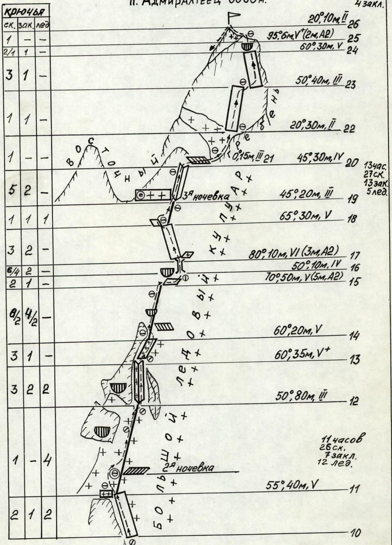

Photo #2. Profile of the buttress from the East. Taken from under the walls of the North-Western buttress of peak Ak-Su. Lens - T-43 (F=75). Distance - 2 km. Height - 3900 m. Date - July 21, 1983. Time - 10:00.
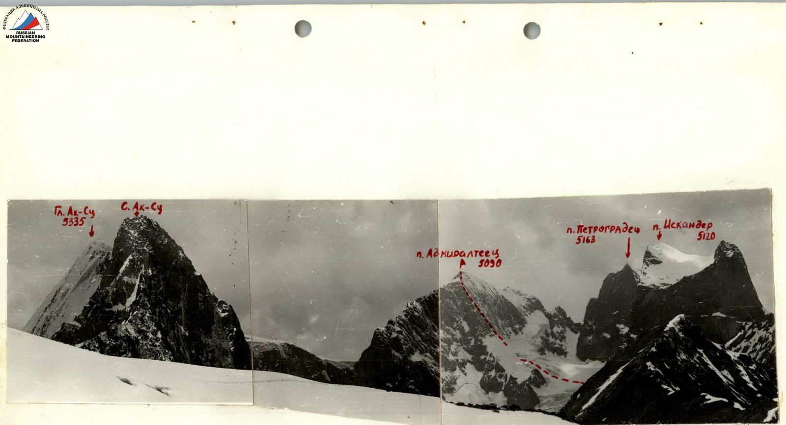
Photo #3. Panorama of the ascent area.
Taken from a snowy plateau west of peak A. Blok. Lens - G-44-2 (F=58). Distance - 4 km. Height - 4100 m. Date - July 12, 1983. Time - 13:00.
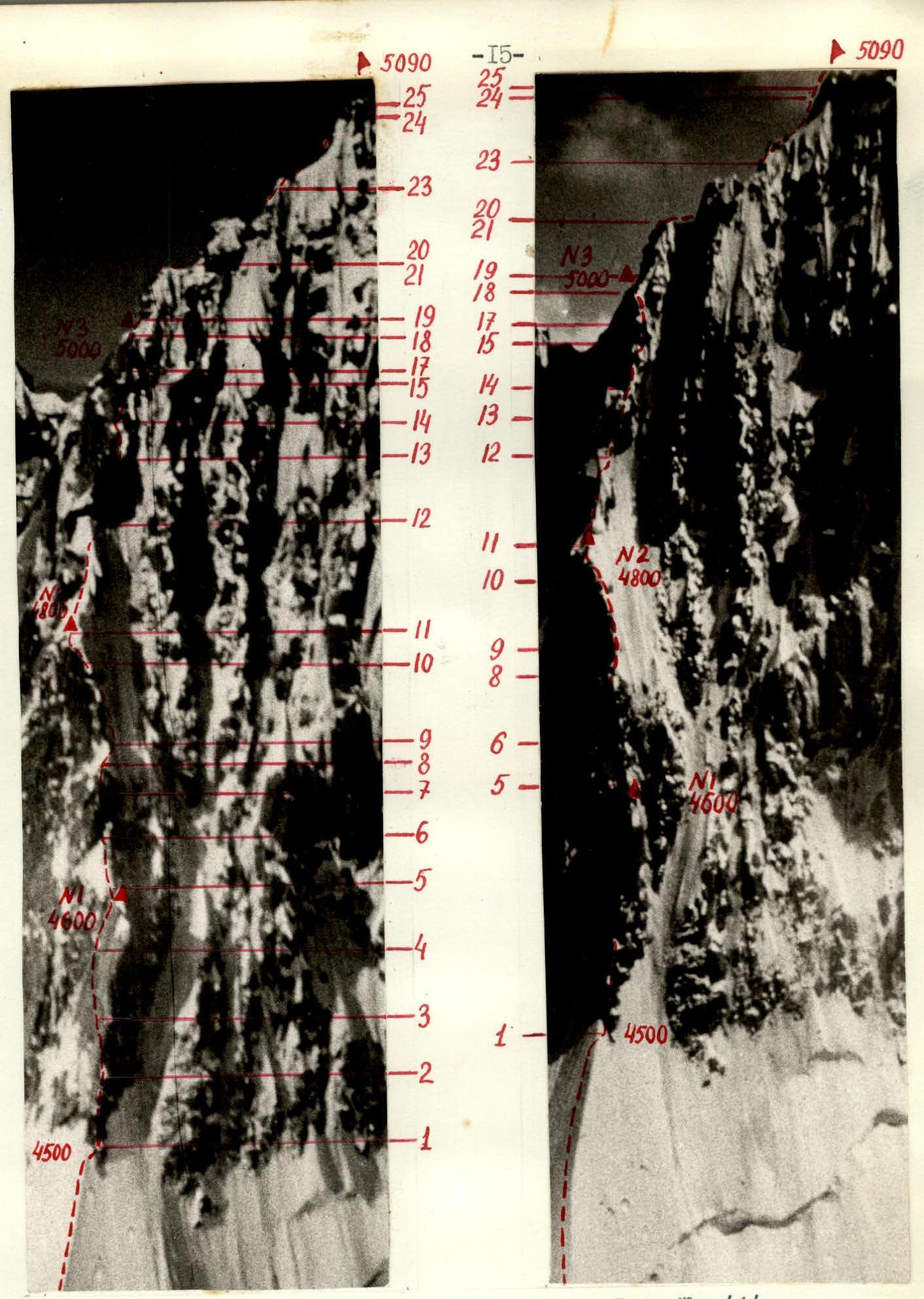
Technical photographs of the route. Taken from the Western ridge of peak Iskander. Lens - I-25 M (F=52). Distance - 1 km. Height - 4700 m (a), 4900 m (b). Date - July 23, 1983 (a), July 24, 1983 (b). Time - 11:00 (a), 18:00 (b).
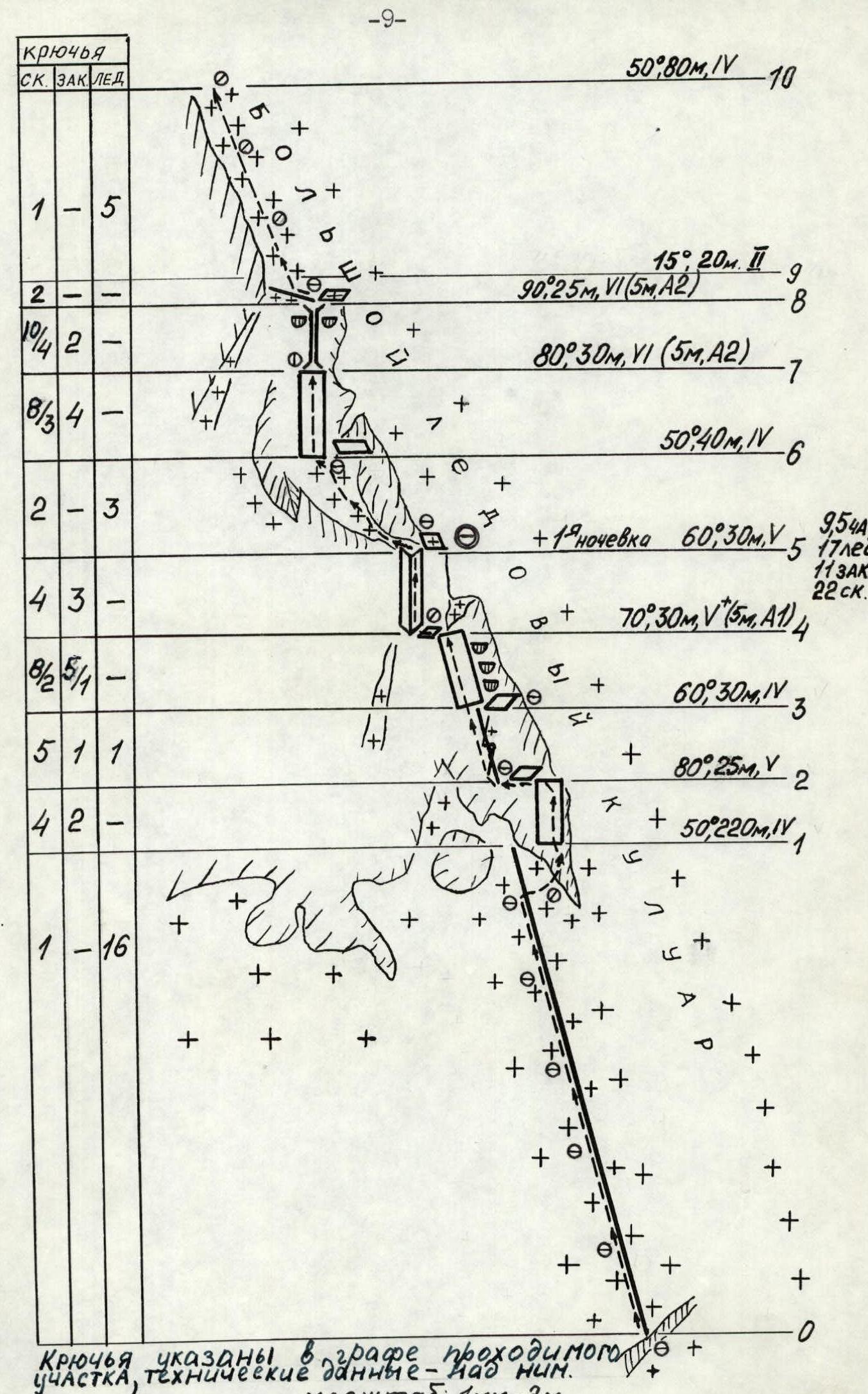
- R0–R1. Ice edge, covered with a 10–20 cm layer of powdery snow.
- In the upper third - pure ice.
- The left part is lit by the sun after 9:00.
- Avalanche hazard in the second half of the day.
- Traversed in crampons.
R1–R2. Steep rocky wall with a limited number of holds. Traversed in galoshes.
R3–R4. Steep, smooth slab with a limited number of holds. Ascending straight up is impossible due to three rock cornices. Traversed in a direction left-up.
- Rocks are wet.
- ITO was used during the passage.
- Traversed in galoshes.
R4–R5. Inner corner with accumulated ice. Rocks are wet. Many loose rocks (under rockfall is the section R3–R4). Passage requires great caution.
At the end of the section:
- snow-covered ledge.
- here you can prepare a site for one tent.
R5–R6. Steep snow-ice slope. Traversed in crampons. Insurance through ice screws and rock hooks.
At the end of the section on the rocks to the right, at a height of 1.5–2 m:
- long,
- convenient ledge for four people.
R6–R7. Very complex smooth monolithic wall with overhanging sections. Traversed in galoshes. Ladders were used during the passage. Passage along the rope with a backpack is difficult.
R7–R8. Wet, in the lower part, overhanging chimney. Ladders were used during the passage. At the end of the section on snowy terrain, it is possible to prepare a site for a tent.
From the technical photograph of the route, it is clear that sections R6–R7 and R7–R8 can be bypassed to the left along a vaguely defined couloir. We refused this path for two reasons:
- Due to the danger of rockfall and snow avalanches.
- Due to the high probability of encountering sections of accumulated ice, the passage of which could cause a lot of trouble (especially the wall in the middle of the bypass path).
However, if in the second half of summer the rocks are freed from accumulated ice, the bypass path may become quite logical.
R9–R10. Steep ice slope. Crampons and ice axes (ice hammers) are required for passage. Insurance through ice screws.
At the beginning of summer, in the second half of the day, the section may be avalanche-prone.
R10–R11. Snow-covered rocks with accumulated ice. Further movement along the ice couloir is dangerous due to the overhanging snow cornice. Traversed in crampons. Insurance through ice screws and rock hooks. The possibility of organizing intermediate insurance points is very limited. Climbing requires great reliability.
R11–R12. Snow-ice slope. Snow is deep, powdery. In some places, it lies on rocky slabs. Insurance through ice screws. A convenient bivouac in a tent on a dug-out site is possible.
R12–R13. Steep icy inner corner. Ice is thin (in some places 2–3 cm), fragile. Rocks are smoothed. Traversed in crampons with the use of ice axes. For insurance, all safety elements are used:
- hooks,
- ice screws,
- chock stones. Climbing requires great reliability.
R13–R14. Snow-covered inclined ledge. Insurance through rock hooks.
R14–R15. Very steep sharp rocky edge. On this section, the buttress turns into an edge. Traversed in galoshes on the left side. The overhanging section is overcome with the use of ladders.
R16–R17. Wet chimney. Rocks are smoothed, traversed in galoshes with the use of ITO. Leads to a narrow snow-covered ledge. The belayer hangs in a harness under a snow-water "shower".
R17–R18. Steep smooth slab. Traversed in galoshes. Ends with a flat rocky balcony for 3–4 people.
R18–R19. Section leads to the Eastern ridge of peak 5090 (Admiralteets). At the end of the section - a wide scree snow-covered ledge, girding the entire Eastern ridge.
Note:
- In the western end of the ledge - a convenient place for one tent.
R21–R22. A convenient bivouac is possible.
R23–R24. Steep, smooth slab, ending in a cornice.
R24–R25. Cornice of the summit tower. Overcome "head-on".
The descent from the summit is made in the direction of the Southern ridge:
- First, 60 m along a snow-covered couloir, leading to rocky drops.
- From here, to the right, an 80 m rappel to snowy fields.
- Then to the left in the direction of the Southern ridge (cornices!) to a low columnar gendarme.
- From here, the descent is made along sheer wet "ram's foreheads" with waterfalls in a direction to the right-down. The descent is made by rappel. The total length of this descent is 320 m.
- The descent ends with a wide snowy slope-couloir, along which it is easy to descend to the moraine deposits of the Kara-Su gorge.
However, apparently, this descent path is not optimal. From the columnar gendarme, one should look for a descent to the simple Southern ridge and along its snowy-scree slopes descend into the Kara-Su gorge.
Footnotes
-
Hooks are indicated in the column of the traversed section, technical data - above it. Scale: 1 mm – 2 m. ↩