Ascent Passport
- Ascent category — high-altitude technical.
- Ascent area — High-altitude Matcha node, Turkestan Range.
- Ascent route — Peak Fedchenko 5400 m, via the West ridge through the Ice Dome.
- Estimated category of difficulty — 5B
- Route characteristics: height difference — 1300 m, length of sections with 5th category of difficulty — 1010 m, average steepness of the rocky ridge — 75°, ice slope — 55°
- Pitons hammered: rock — 28, ice — 18, hexes — 10
- Number of climbing hours — 21.
- Number of bivouacs and their characteristics. Two bivouacs, both in a hollow under the beginning of the rocky part of the route, the place for bivouacs is very convenient.
- Team composition: BUDYANOV V.P. — Candidate for Master of Sports, team leader ANDREEVA T.N. — 1st sports category GRISHCHENKO A.I. — 1st sports category GUTIN V.B. — 1st sports category
- Team coach — PROKOPENKO V.I.
- Date of departure on the route — August 2, 1978.
Return — August 4, 1978.
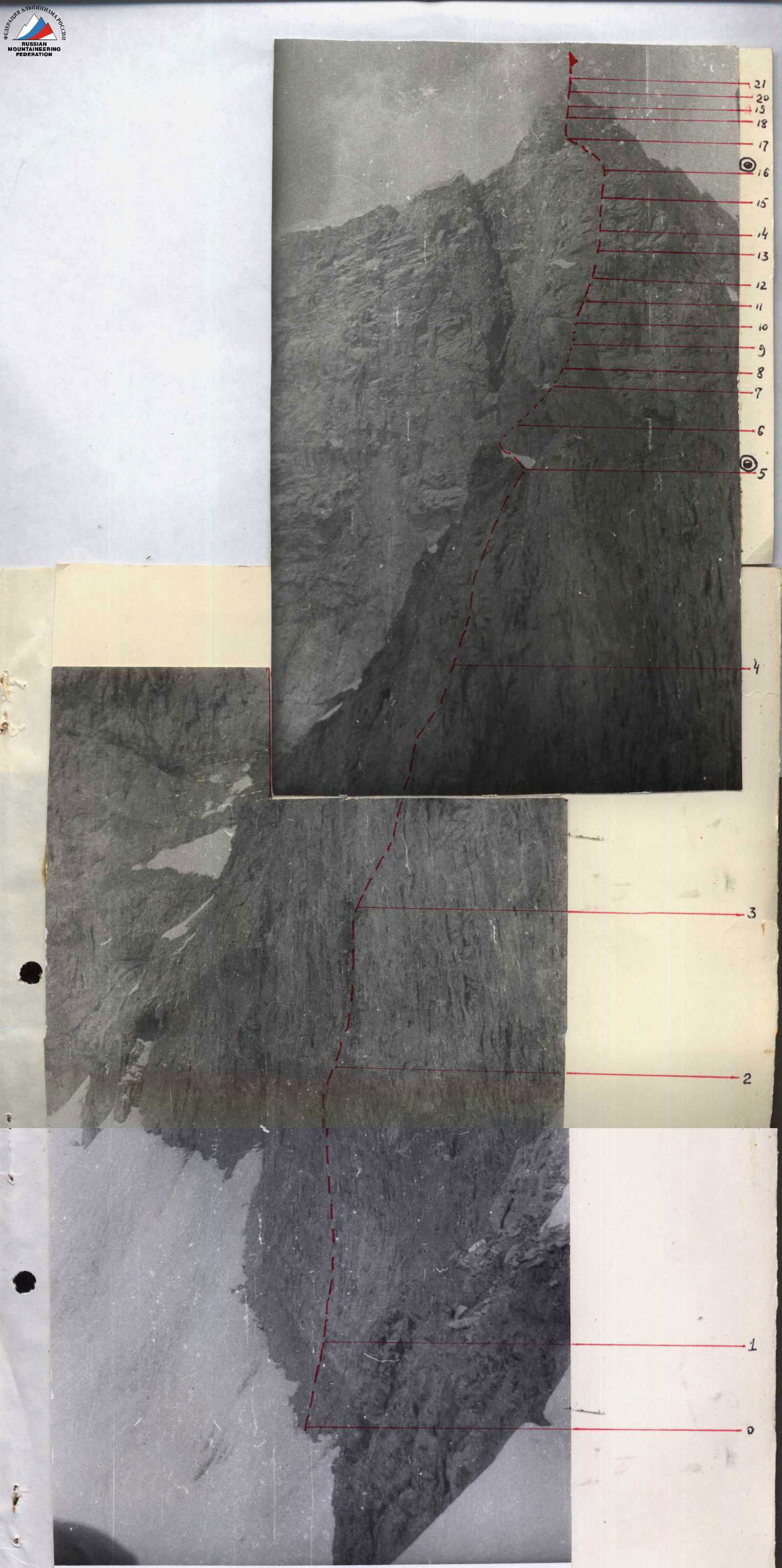 Route photo with marked sections (supplement 2)
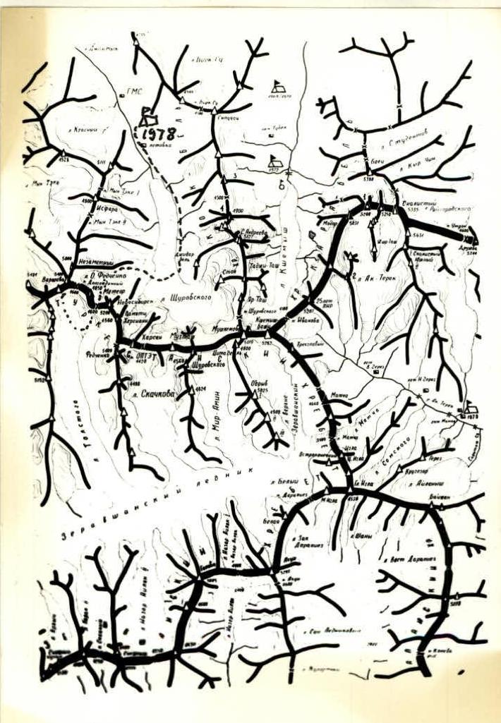
Photo 1. Orographic scheme of the area. Ascent route ... Base camp △ 1978. Change of peak names in the classification table: former — current
- Warsaw — Fedchenko
- Novosibirsk — Turkestan
- Fedchenko — Zemleprokhodtsev
- Kiroksan — Novosibirsk
- Yar-Tash — Krutoy kamen
- Citadel — Topografa Petrova
- Modar — Skalistaya (103)
- Tadj-Tash — Solnechnaya lestnitsa
- Muz-Tash — Shchurovskogo (3)
- Vertikal — Skalistaya (3rd Z)
Description of the route passage
August 2, 1953. First day of ascent. The group left Korolev Pass at 7:00, descended along snow-ice fields to the Tolstoy Glacier (in the lower part, the descent was on ice with insurance through ice axes and an ice piton hammered into the rocks) and by 10:00 climbed to the upper circus of the glacier. At 10:00, the group began the ascent along the ice slope. Everyone was wearing crampons.
First section
Snow slope, the steepness of which increases to 50° at the end. Insurance through ice axes. Length 160 m.
Second section
The snow slope turns into an ice slope, with a steepness of up to 60°. Insurance through ice screws (3 pcs.). Section length 180 m.
Third section
Zone of crevasses. A broken ice-snow slope is passed with a detour around crevasses and breaks along snow bridges. In some short places, the steepness of the ice reaches 75°. 5 ice screws were used on the section. Section length 160 m.
Fourth section
Snow slope broken by two bergschrunds. The lower one is passed on the left side along a snow bridge, the upper one is in the middle part, also along a snow bridge: the exit from the bergschrund is a three-meter snow wall, which is passed using two ice axes. Reliable insurance can be organized through an ice axe along the entire section. Section length 160 m, steepness — 60°.
Fifth section
Left slope, length 240 m. Steepness is initially 50°–60°, then flattens to 40° (before the Ice Dome summit).
Photo 2. General view of Peak Fedchenko.
 Passed with thorough insurance through ice pitons (10 pcs.). The summit of the Ice Dome has virtually no horizontal area: the South slope simply drops to the North with a wall and a cornice (see photo 4).
Sixth section
Not reaching the summit of the Ice Dome, to the right along the ice slope, ten meters below its upper part — a traverse with almost no gain in height. Length 450 m, slope steepness 35°–45°. The traverse ends with an ice crevasse, after which, 15 m later, the slope suddenly breaks off with a 4-meter ice wall, forming a hollow around the base of the West ridge of Peak Fedchenko. To the North, the hollow drops with a one-and-a-half-kilometer wall. The hollow is reliably protected from rockfall by a smooth overhanging wall at the end of the West ridge. A good platform for a tent was laid out on the shelf of this wall. From the tent, there is an excellent view of the Ice Dome (photo 4). The Western exposure creates good conditions for evening work on organizing a bivouac in sunny weather. The ascent from Tolstoy Glacier to the hollow took 11 hours.
August 3, 1953. In the morning, the sun appears in the hollow late (at 10:00). Strong wind and cold (altitude about 5000 m) greatly complicated preparations for the exit. They left for the route at 8:00. The excellent condition of the route allowed everyone to leave in galoshes. They took a tent and warm clothes (down jackets) with them in case of a possible bivouac on the ridge (according to the tactical plan, the descent was planned along the ascent route).
Seventh section
From the bivouac site, 20 m along the bottom of the hollow, bypassing the overhanging wall. Behind it, there are two vertical inner corners. Up the second inner corner, 30 m (insurance through pitons). Then a traverse to the left:
- first along a shelf,
- then along a vertical slab, leaning away from it and holding onto rock protrusions with hands (10 m),
- onto a scree shelf. Total 80 m. 4 pitons were hammered.
Eighth section
From the shelf, 20 m to a smooth inclined slab, with a steepness of 50°. Up the slab on the left side, 20 m, and another 30 m of simple rocks to the beginning of the chimney. Insurance through protrusions and pitons (2 pcs.).
Ninth section — chimney
The total length of the chimney is 40 m, average steepness 80°, in the middle part — 90°. Climbing the chimney with piton insurance and ladders, using friction and jamming of hands and feet. In the middle part, the chimney has smooth vertical walls (monolith). Climbing is possible only by jamming into a 15–20 cm wide gap. At the top, the chimney ends with destroyed rocks (25 m) and a monolithic slab (5 m), leading to a shelf. Section length 70 m, steepness 80°. 6 pitons and hexes were used.
Tenth section
From the shelf, the wall is initially not steep (45°), then up to 90° with good holds, leading to a second scree shelf. Total length 120 m. Insurance through protrusions and pitons (2 pcs.). If necessary, a bivouac can be organized here.
Eleventh section
From the scree shelf begins a rocky wall with fractures, total length 80 m, steepness 90°. First, under an overhanging characteristic striped rock, from it to the right along a vertical wall (15 m) and further along monolithic inclined slabs under the next wall with an overhang. Passed first on the right side (10 m) along small ledges, then a traverse to the left under the overhang (8 m). Then up along a crack (10 m) to a characteristic section: a chimney with a vertical spalled finger. After reaching the finger — a transition to the wall and further to an inclined slab. 8 pitons were hammered, ladders and cams were used.
Twelfth section
First, a traverse to the left along a vertical wall, 20 m, then a descent into a couloir and along the couloir, 60 m, to a narrowing in the form of a groove, which is passed along the left wall. Further, straight up, the couloir is filled with snow with a steepness of 60°. A route was chosen to the left along the rocks: first a chimney, 25 m, then a wall, 25 m, and 20 m of ridge with dips, leading to the summit. Section length 150 m, steepness 75°–80°. 6 pitons were hammered. The ascent to the summit took 10 hours. There is a place for a tent.
Descent from the summit along the ascent route. First, two rappels along the couloir — 80 m and 70 m. Then a free rappel, 80 m. Further — 80 m of sport descent to the chimney and a rappel in the chimney (40 m). From the chimney, again sport descent — 80 m — and the last rappel along a vertical wall (60 m) into the hollow. Bivouac here. The descent to the hollow took 4 hours.
August 4, 1953. Continuation of the descent. Departure at 9:00. The descent route along the ice section almost coincided with the ascent route. On the descent, three ice pitons were used (left) to organize the rope traverse. The descent to Tolstoy Glacier took 5 hours. Just as much time was needed to climb Korolev Pass to the observers' tents.
Conclusions
According to observation results, it was considered that there would be two key sections on the route:
-
- passing the ice slope,
-
- passing the rocky ridge.
Passing the route showed the correctness of these assessments: the difficulty of the ice section can be estimated as category 5A, and the rocky section as 5B.
The group's movement schedule practically coincided with that planned according to the tactical plan.
Overall, the route can be assessed as category 5B.
It should be noted that the route was passed in excellent weather conditions, which facilitated its passage, especially the rocky part.
The successful passage of the route was also facilitated by the use of new technical means:
- ice hammers with anchor beaks;
- ice screws;
- rock hexes;
- devices for pulling out pitons.
Photo 3. Profile photo of the West ridge of Peak Fedchenko from the South.
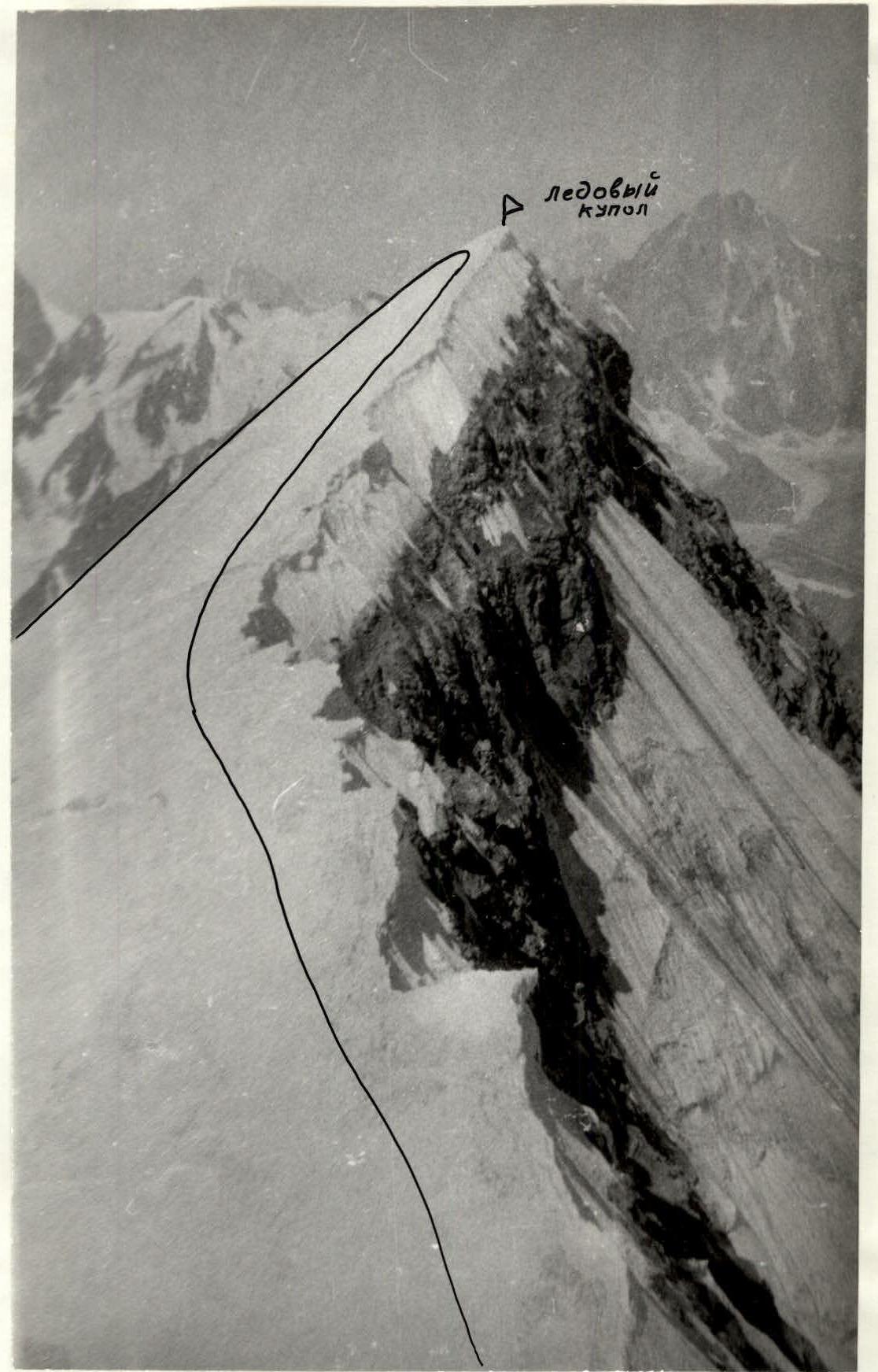
Photo 4. Profile photo of the summit part of the Ice Dome. View from the West ridge. Peak Fedchenko.
Table № 2. Table of main characteristics of the ascent route
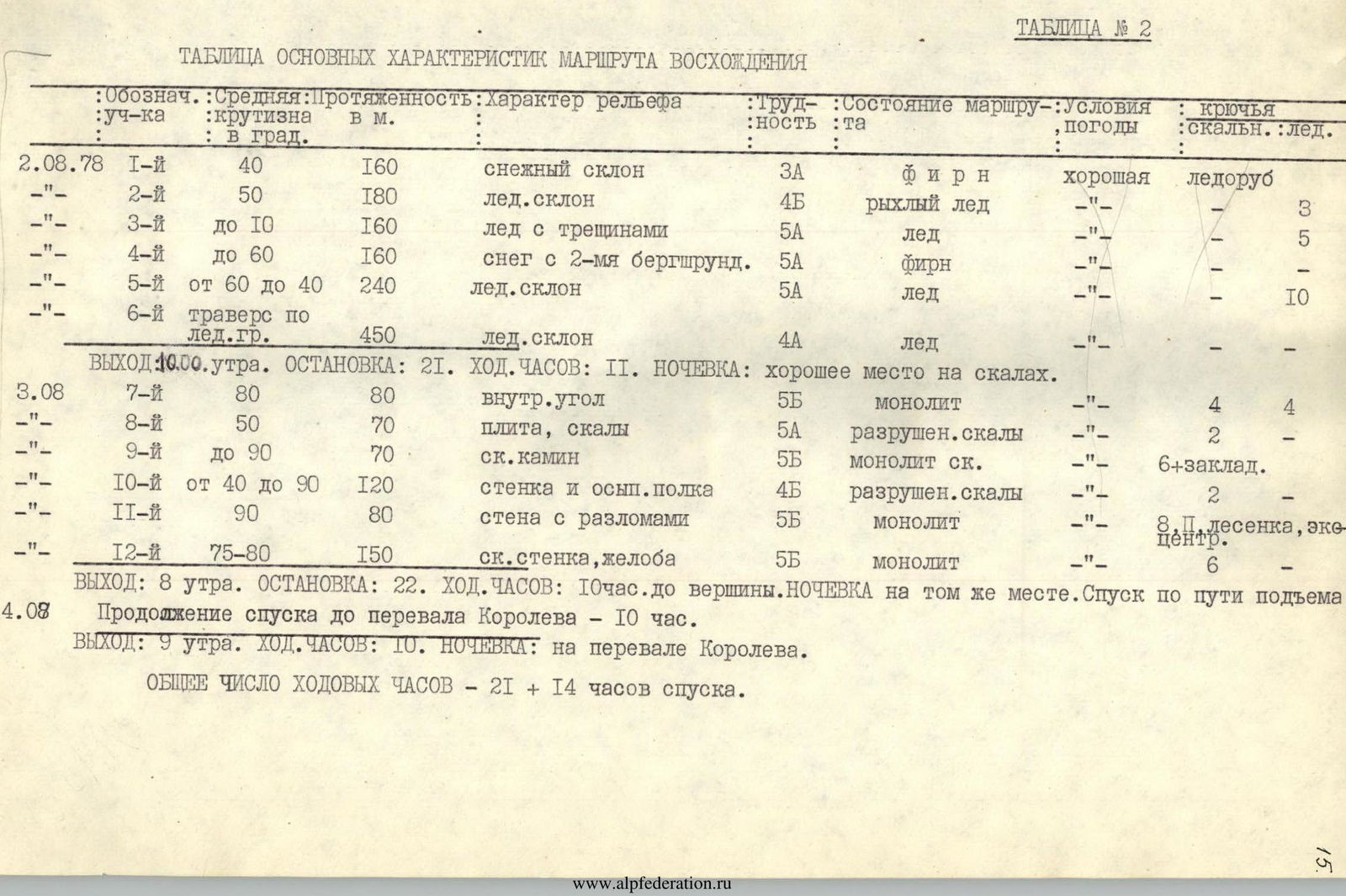
| Section designation | Average steepness in degrees | Length in m | Character of relief | Difficulty | State of the route | Weather conditions | Rock pitons | Ice pitons |
|---|---|---|---|---|---|---|---|---|
| August 2, 1978 | ||||||||
| R1 | 40 | 160 | snow slope | 3А | firm snow | good | ice axe | |
| R2 | 50 | 180 | ice slope | 4Б | loose ice | — | 3 | |
| R3 | up to 10 | 160 | ice with crevasses | 5А | ice | — | 5 | |
| R4 | up to 60 | 160 | snow with 2 bergschrunds | 5А | firm snow | — | — | |
| R5 | from 60 to 40 | 240 | ice slope | 5А | ice | — | 10 | |
| R6 | traverse along ice ridge | 450 | ice slope | 4А | ice | — | — | |
| Departure: 10:00 AM. Stop: 21 climbing hours. Bivouac: good place on rocks. | ||||||||
| August 3, 1978 | ||||||||
| R7 | 80 | 80 | inner corner | 5Б | monolith | — | 4 | 4 |
| R8 | 50 | 70 | slab, rocks | 5А | broken rocks | — | 2 | — |
| R9 | up to 90 | 70 | rocky chimney | 5Б | rocky monolith | — | 6 + hexes | — |
| R10 | from 40 to 90 | 120 | wall and scree shelf | 4Б | broken rocks | — | 2 | — |
| R11 | 90 | 80 | wall with fractures | 5Б | monolith | — | 8 loops, ladder, cams | — |
| R12 | 75–80 | 150 | rocky wall, gullies | 5Б | monolith | — | 6 | — |
| Departure: 8:00 AM. Stop: 22 climbing hours to the summit. Bivouac at the same place. Descent along the ascent route. | ||||||||
| August 4, 1978 | ||||||||
| Continuation of descent to Korolev Pass 10 hours. | ||||||||
| Departure: 9:00 AM. Climbing hours: 10. Bivouac: on Korolev Pass. | ||||||||
| Total climbing hours: 21 + 14 hours of descent. |