ROUTE TO PEAK "MLADSHIY" VIA THE SOUTHEAST RIDGE (CATEGORY 5A DIFFICULTY)
The first ascent of this peak was made on July 25-26, 1969, by a group of climbers from the Arzamas-16 gathering, consisting of:
- ZHELONKIN E. F.
- PAVLOVSKY E. S.
- RUDNEV V. S.
- SOFRONOV I. D. (leader)
Peak "Mladshiy" is located at the beginning of the southern spur of the Turkestan Range, leading to the "Obryv" peak. The nodal peak connecting this spur to the Turkestan Range is a higher unnamed peak situated close to "Mladshiy" and linked by a relatively high and short saddle (approximately 0.5 km). The proximity of "Mladshiy" to the higher unnamed nodal peak led the first ascensionists to suggest the name "Mladshiy" for their ascent target. Both peaks are visible from the "Matccha" pass and enclose the upper valley of the Zeravshan Glacier (see Fig. 1 and Fig. 2).
To the southeast, towards the head of the Zeravshan Glacier, a short ridge descends from the summit tower of "Mladshiy," along which the ascent was made. The route along this ridge was purely rock climbing, even in the snowy conditions of 1969. The average steepness of the route is 60°.
- The lower half of the southeast ridge is composed of grey-yellow rocks.
- The upper part and the summit tower itself are made of red-rusty rocks, representing a very unstable conglomerate of gravel with clay (rock type G).
The ascent began from the assault camp located on the Zeravshan Glacier below the "Kshemysh-bashi" peak at 8:00 on July 25, 1969 (camp altitude 4100 m, as shown in Fig. 1 and Fig. 2).
The approach to the black rocks adjacent to the southeast wall of "Mladshiy" (point 1 on Fig. 3), bypassing most of them via snow to the left, and reaching the southeast wall (point 2) took approximately 2 hours. The path then proceeded upwards to the right towards the southeast ridge, on its left side. The movement was alternating with protection through ledges and rock gullies. The most difficult part of this section was the exit onto the ridge itself (last 50-60 m), where the rock steepness reached 70-75°. Immediately after reaching the ridge (at point 3), the group moved to its right side, where the first control cairn was built in a snow pocket (altitude 4630 m, time 13:15).
The location of the first control cairn at point 3 is considered logical by the group, as bypassing this point on either side is noticeably more difficult than the direct ascent to it.
From the first control cairn to the second (point 4), the path proceeds along the right side of the southeast ridge: first through a gentle (25-30°) snow gully, then along ledges, and finally, an exit left onto the ridge via difficult rocks, with protection through sparse ledges and pitons. The second control cairn was built before the start of the red-rusty rocks (type G, altitude 4810 m, time 16:15). Here, an overnight bivouac can be organized. The further path goes directly along the ridge with minor deviations: first left, then right, then left again. After a relatively gentle shoulder, a steep ascent follows, at the beginning of which there is a short (4 m) vertical wall with a crack on the right side. The wall should be climbed directly up the crack without a backpack. Attempts to bypass the wall were unsuccessful. Further climbing involves rocks of medium difficulty, movement through a gully made of type G rocks, exiting onto the ridge, and transitioning to the left side of the ridge, followed by another gully of type G rocks (point 5). From the wall to the last gully is approximately 150 m. The gully ends with an overhanging wall, and at the junction with the left lateral wall, there is a crack filled with flow ice - an icicle. After clearing the crack of ice blocks, it became possible to ascend (without a backpack) into the upper part of the crack and, by installing necessary wedges and pitons in the left wall, exit along a narrow ledge upwards to the right (under point 6). The further path to the summit (150-200 m) proceeds along fairly steep rocks of type G.
The summit is a fairly large inclined platform made of type G rocks, where it is easy to clear a spot for a tent. The group reached the summit at 14:30. The summit altitude is 5010 m.
Note: All altitude measurements were made with an altimeter, which, considering the approaching bad weather, could give an error of several tens of meters.
The section of the route from the second control cairn to the summit (between points 4 and 7) is the most challenging, filled with technical difficulties. Throughout this section, the first in the group climbed with great difficulty (sometimes without a backpack), and the others followed in a sport climbing manner.
For the descent from the summit, a route along the southern ridge was chosen. One can follow the ridge to the saddle or descend a bit earlier via one of the snow gullies.
Leaving the ridge too early is undesirable, as the high-lying gullies lead out onto ice fields.
In assessing the difficulty category of the ascent to "Mladshiy" via the southeast ridge, the group considered their experience with classified routes of categories 4B and 5A difficulty (3-4 ascents per group member).
The route taken:
- is substantially more difficult and longer than the traverse of "Korona" (Kyrgyz Ala-Too, category 5A);
- is substantially more difficult and longer than the traverse of "Maly Sugan" (Digoria, category 5A);
- is equally complex but longer and more rockfall-prone than the ascent up the wall to the 6th tower of "Korona" (Kyrgyz Ala-Too, category 5A);
- is significantly more difficult and longer than the routes to "Taldor Glavny" (Digoria, category 4B) and "Nakra-tau" (Baksan, category 4B).
The group therefore proposes to classify the route to "Mladshiy" via the southeast ridge as a category 5A route.
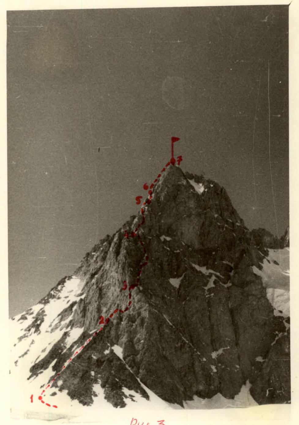
Fig. 3
| Date | Section Covered | Average Steepness | Altitude Gain | Characteristics of Sections and Conditions | Time | Pitons Driven | Remarks |
|---|---|---|---|---|---|---|---|
| By Relief | By Technical Difficulty | By Insurance Method | |||||
| By Weather Conditions | |||||||
| Exit | Bivouac Stop | ||||||
| 1st Day | R0–R1 | 10° | 100 m | Glacier covered with firn. Few crevasses. | Easy | Simultaneous with self-insurance | Good |
| R1–R2 | 45° | 250 m | Initially snow where steps were kicked, then rocks. | Medium difficulty section, snow quite steep. Had to move in three stages. | Through ledges and pitons | ||
| R2–R3 | 60° | 150 m | Steep, fairly smooth rock wall. Steepness reaches 70-75° at the top. | Difficult section, especially the upper part. Few holds, ledges are rare. | Through ledges and pitons | ||
| R3–R4 | 55–60° | 200 m | Initially a gentle snow gully, then rock ledges, and finally an exit onto the ridge via rocks. | Path through the snow gully is easy, but protection from rockfall is needed. Ledges are of medium difficulty. Exit onto the ridge via medium rocks: few holds, ledges for insurance are present but rare. | Through ledges and pitons | ||
| R4–R5 | 60° | 70 m | Rocks of type "G" (conglomerate of gravel and clay). Initially gentle, then a steep ascent with a short vertical wall (4 m) with a crack. | Overall difficult section, especially the vertical crack. | Through ledges, ice axe, wedges | ||
| R5–R6 | 85° | 10 m | Crack in the internal angle formed by vertical and overhanging walls. The crack is filled with flow ice - an icicle. | Difficult section. Frequent rockfall forced all participants to be extremely cautious. | Through ledges and wedges | ||
| R6–R7 | 60° | 120 m | Steep rocks of type "G". There are two pockets where a bivouac can be organized. | Overall difficult section. Few holds, but sparse ledges allow for reliable insurance almost everywhere. | Through ledges and wedges | ||
| Descent was made along a simpler ridge and took approximately 6 hours. |