- Climbing category — traverse.
- Climbing area — Pamir-Alay, Turkestan Range, upper reaches of the Tolstoy Glacier.
- Climbing route — North — 5430 m (via the northeastern ridge), Central — 5585 m, South — 5450 meters LGI.
- Climbing characteristics:
height difference of the Northeastern ridge — 900 m,
average steepness of the northeastern ridge 45–60°,
length of challenging sections:
- 5th category of difficulty — 1020 m
- 5–6 category of difficulty — 80 m
- 6 category of difficulty — 120 m
- Hooks used: rock — 149 ice — 24.
- Total climbing hours — 51.
- Number of nights and their characteristics — 7, directly on the traverse — 6.
- Team name: Team of the Leningrad Mining Institute named after G. V. Plekhanov.
- Full name of the team leader, participants, and their qualifications: captain — NEZAMETDINOV Aidar Barievich — Master of Sports of the USSR participants — MARKOV Dmitry Prokofievich — Candidate Master of Sports IVALTSEV Vadim Kornilovich — Candidate Master of Sports VERGILESOV Fedor Vladimirovich — Candidate Master of Sports
- Team coach — PULINETS Yuri Semenovich — senior instructor, Master of Sports of the USSR.
- Dates of departure and return: July 30 — August 8, 1973.
Traverse Details
- Peak LGI — ascent via the northeastern ridge from the Tolstoy Pass (first ascent, route approximately 5B category of difficulty) (North Peak) 5430 m — descent via the southern ridge (new route, approximately 4th category of difficulty)
- Peak LGI — ascent via the northern wall (new route, approximately 5B–6B category of difficulty) (Central Peak) 5585 m — descent via the southern ridge (new route, approximately 4th category of difficulty)
- Peak LGI — ascent via the northern ridge (new route, approximately 3A category of difficulty) (South Peak) 5450 m — descent via the southwestern ridge (new route, approximately 5B category of difficulty)
Anniversary climbing event leader — Master of Sports of the USSR (Yu. Pulinets)
Team captain — Master of Sports of the USSR (A. Nezamtdinov)
Team coach — Master of Sports of the USSR
(Yu. Pulinets)
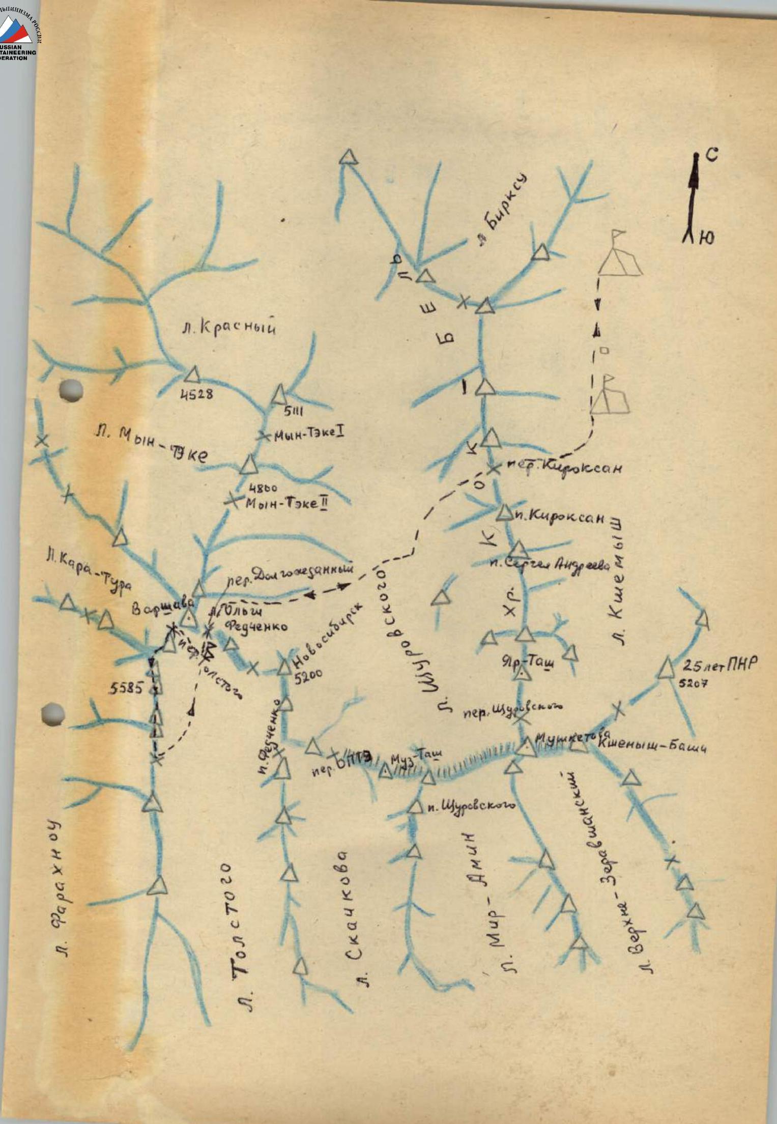
Brief Geographical Description of the Climbing Area. The Matcha High Mountain Knot.
To the south of the Fergana Valley, a continuous chain of peaks stretches for over 700 km. Its eastern half is known as the Alay Range. Almost exactly in the middle, the chain splits into a giant fork, inside which lies the Zeravshan Valley. The northern branch of this fork is the Turkestan Range, and the southern one is the Zeravshan Range. From the latter, to the west, the Gissar Range branches off, completing the formation of the trident. Geologists include it in the Western Tien Shan system, while climbers call it the Pamir-Alay.
The junction of the three ranges — Alay, Turkestan, and Zeravshan — is known as the Matcha node. It is indeed a node with intricate ridges and spurs, between which numerous glaciers lie. The largest of these is the Zeravshan Glacier, stretching about twenty-eight kilometers. The most difficult to access is the Raygorodsky Glacier, which descends in a bizarre icefall towards the emerald shores of Lake Kara-Kul-Katta ("Big Black Lake" in Kyrgyz). Exactly at the junction of the three ranges lies the Igla Peak.
Four main valleys are located within the Matcha node. Two of them, the Kshymysh and Jipptyk rivers, flow from the Turkestan Range to the north, forming the Isfara River. The third valley, the Ak-Terek River, begins under the slopes of the Rocky Peak, initially stretching in a wide arc to the southeast, then gradually turning east and northeast, connecting with the Soh River valley. These rivers belong to the Syr Darya basin. Finally, the fourth valley, the Zeravshan River, stretches strictly to the west.
Passes connecting the valleys are not straightforward and have elevations of 3900–4300 m. The highest point in the area is the Main Peak of the Rocky Peak massif (5650 m), located in the Ak-Terek spur of the Turkestan Range. The most significant peaks in the area are:
- Akhun (about 5200 m) — in the Zeravshan Range,
- Peak Shchurovsky (5560 m) — in the Turkestan Range,
- Dong-Chad (about 5300 m) — in the Alay Ranges.
Matcha is not only a node of three ranges but also of three Central Asian republics. The upper reaches of the Zeravshan River are in Tajikistan, the Kshymysh and Ak-Terek valleys are in Kyrgyzstan, and the areas of mountain pastures, the Soh and Sisor valleys, are in Tajikistan and Uzbekistan, where dryland farming and horticulture thrive.
Historical Background
The first researcher to visit the Matcha mountain node was Alexei Fedchenko. A graduate of Moscow University, Fedchenko was a biologist by training but was seriously passionate about anthropology, paleontology, and geology. Therefore, his research was, as they say now, "comprehensive".
In 1869–1871, he lived and worked in Central Asia, studying the flora and fauna of the region from Samarkand to the Alay Valley. He is also credited with the discovery of the Trans-Alay Range and its highest peak, 7134 m (now known as Lenin Peak).
In June 1871, Fedchenko penetrated the upper reaches of the Isfara River and on June 24, ascended to the glacier in the upper reaches of the Jiptek valley, which he named after his teacher, the geologist and paleontologist G. E. Shchurovsky, one of the organizers of Fedchenko's expeditions. Olga Fedchenko, the traveler's wife and constant companion, made her famous drawing "Shchurovsky Glacier and the sources of the Isfara River". It depicts three peaks named after Shchurovsky:
- Main,
- Node,
- Western (now called Muz-Tash).
Fedchenko's expedition laid the foundation for the study of the Matcha mountain node.
In 1880, a large expedition led by I. V. Mushketov, a well-known explorer of Central Asia, traversed the Zeravshan Glacier, passing from the Zeravshan Valley into the Ak-Terek-Soh Valley. The expedition conducted a topographic survey of the glacier.
At that time, the names of glaciers were introduced:
- Tolstoy,
- Skachkov,
- Mir-Amin, as well as peaks:
- Igla,
- Obryv,
- Belaya,
- Akhun,
- Golova, and others.
In 1933–1934, one of the teams of the Tajik-Pamir Expedition of the USSR Academy of Sciences explored the Matcha node, visiting the Kshymysh, Raygorodsky, and Zeravshan glaciers, among others. Climbers traversed from the Shchurovsky Glacier to the Zeravshan Glacier, naming the challenging pass they conquered "OPTЭ" — "Pamir-Tajik Expedition Team". The Matcha Pass was also traversed.
In 1934–1935, climbers (including brothers Abalakovy, A. Maleinov, and others) participated in the exploration and development of tin deposits on the Olovyanaya Mountain in the Turkestan Range. Simultaneously, they managed to make several ascents, including one to Peak Granitny (5056 m) in the Myn-Teke valley.
In 1940, a climbing expedition led by V. V. Nemtsky from the Moscow House of Scientists operated in the Matcha node. Climbers visited the Zeravshan Glacier, conquered Peak Matcha, and traversed from the Kshymysh valley to the Ak-Terek valley via a pass that has since borne the name of the group's leader, "pioneer" A. I. Ivanov.
A challenging pass route was undertaken in the upper reaches of the Utronn and Raygorodsky glaciers. Three climbers — Mukhin, Gusev, and Popov — ascended Peak 5800 m (according to their measurements) in the Ak-Terek spur — apparently, one of the main peaks of the Rocky Peak massif.
After the war, climbing groups led by A. Zyryanov (1955) and Bleshchunov (1958) visited the Matcha node area. However, they did not make any ascents.
The primary climbing exploration of the area was conducted by climbers from Novosibirsk's "Vertical" climbing club. Participants in their expeditions (1969–1970 and 1971) made the most significant ascents in this area and largely conquered all the peaks of the Turkestan Range and its spurs. Their undeniable achievement is that the classification table of mountain peaks in the USSR already lists 47 routes to the main peaks of this region, and a sports branch of the "Dugova" alpine camp began operating this year.
However, there is still much to be explored in the area. This mountain country undoubtedly deserves thorough research and study.
Matcha awaits its first ascenders.
Sports Characteristics of the Traverse Object
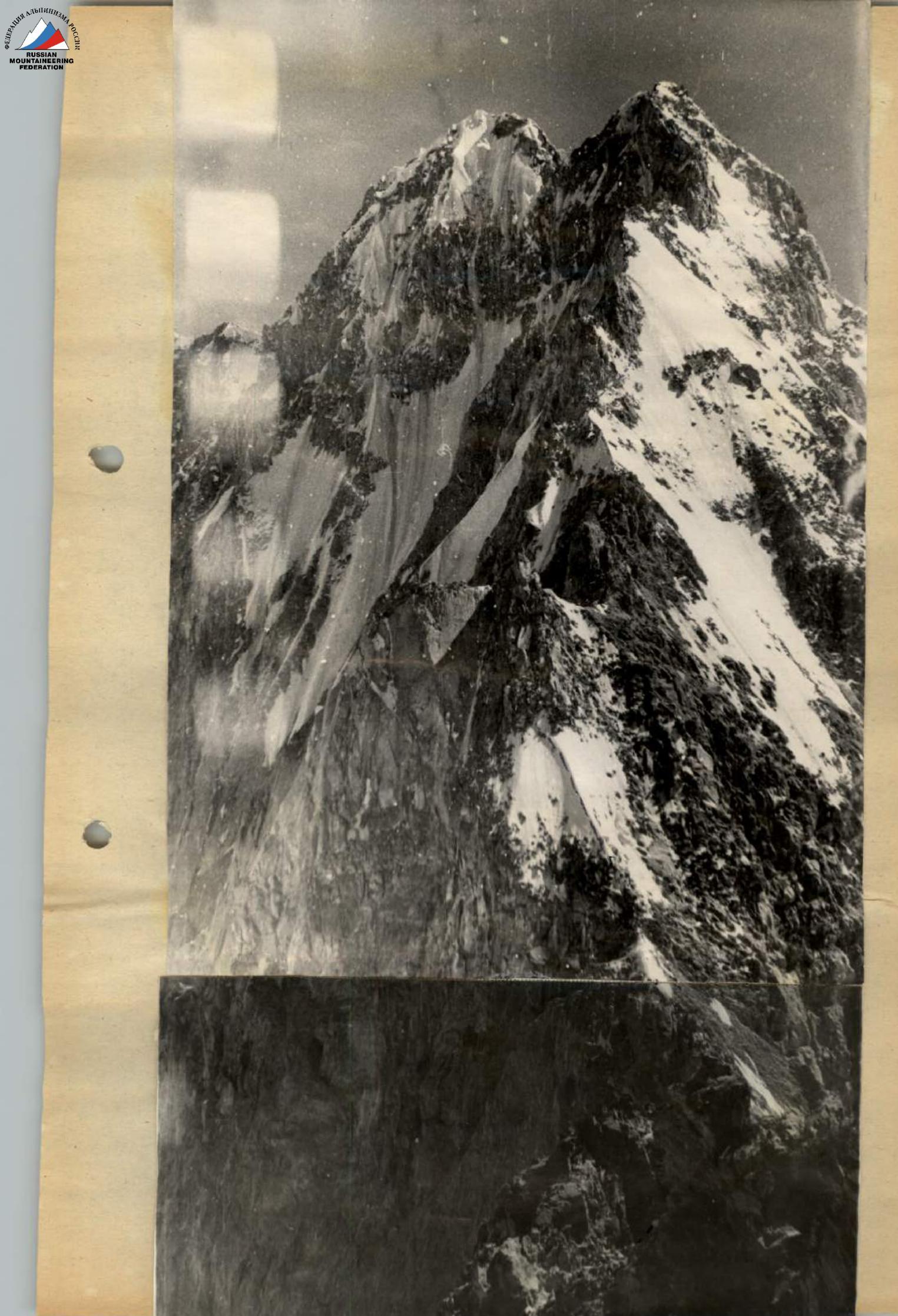
The traverse object is a large rock massif with snowy cornices and ice-rock walls, consisting of three peaks. When viewed from the Tolstoy Glacier, the right peak is referred to as the North Peak, the middle one as the Central Peak, and the left one as the South Peak, as they are somewhat offset from north to south.
From the Tolstoy Glacier, the eastern wall of 5585 m is clearly visible. The northeastern ridge approaches the massif from the Tolstoy Pass, with a preliminary difficulty assessment of 5B category.
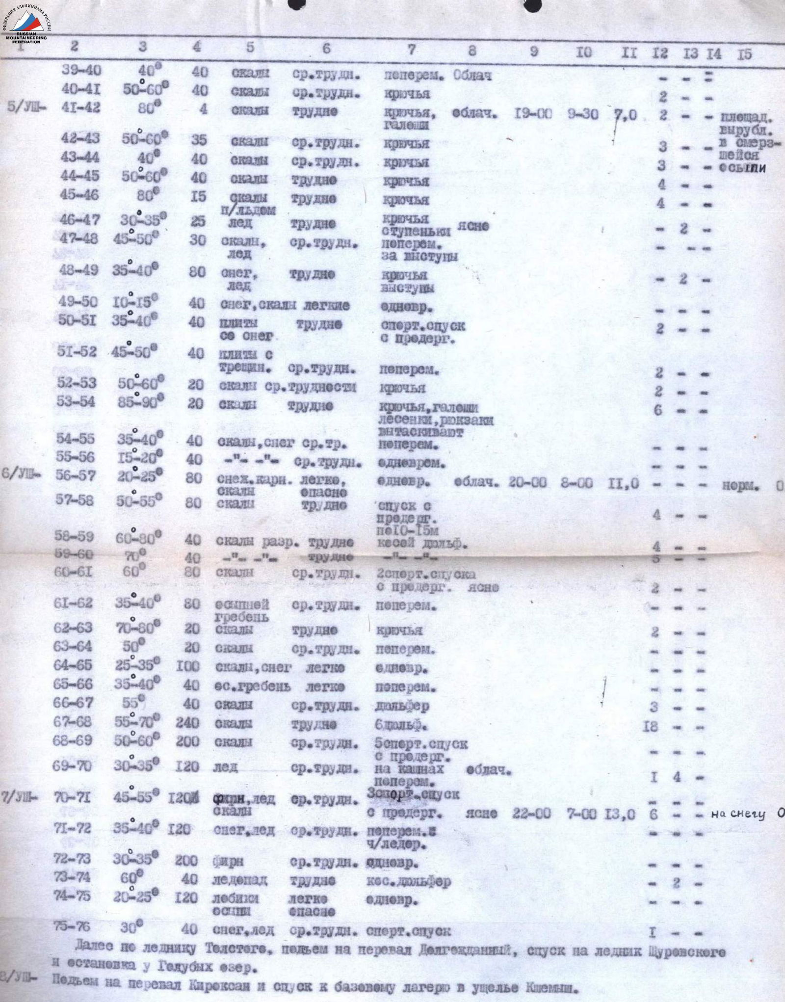
The route is a new, previously unclimbed traverse. The traverse length, including the ascent, is 3720 m, completed in 51 hours, and features complex ice and rock sections.

The ascent from the other side through the icefall, the saddle between peak 5585 and the neighboring peak to the south, is considered to be of the 5th category of difficulty by the group, although it contains fewer ice sections, it is more prone to rockfall.
Brief Description of Climbing Conditions
The base camp of the Leningrad Mining Institute alpinade, to which the team belonged, was located in a good juniper forest, about a 2-hour walk from the Kshymysh Glacier, at the site of the "Vertical" club's base camp in 1969.
The base camp can be reached from the nearest railway station, Kanibadam, as follows:
- Kanibadam — Isfara district center — 20 km — bus — 0 h 30 min.
- Isfara — Vorukh village — 48 km — bus — 1 h 30 min.
- Vorukh — Mazr tract — 14 km — random vehicles — 1 h.
- Mazr — base camp — good trail — donkeys — 8 h.
The nearest alpine camp, "Dugoba", is approximately 150 km away by road. This year's branch of the "Dugova" alpine camp was located further up the valley, a 1-hour walk from us.
The mountains of the Matcha node are of the Alpine type. With sharp and pointed outlines, they remain above 3500 m over a significant distance. The snowline on the northern slope is at an altitude of 3500–4000 m, while on the southern slope, due to the dry climate, it is somewhat higher. The Turkestan Range is composed primarily of siliceous and clay shales, sandstones, limestones, and occasionally marble, granite, syenite, gabbro, and fluorite. Due to the combination of such diverse rock strengths and the sharply continental climate, the rocks are heavily weathered, resulting in significant rockfall hazards. This summer was particularly hot and dry, with slopes completely cleared of snow, increasing the complexity of ice routes and rockfall hazards in the area.
The climate of the node is moderately continental, and in the foothill regions, moderately warm. Abundant sunshine. The average annual duration of sunshine is 2500–2700 hours (about 1600 hours in Moscow), with hot summers but no sultry weather. Winters in the mountains are cold, with frosts.
One of the climate's features is the uneven distribution of precipitation across the territory. In nearby locations, weather conditions can differ significantly on the same day. Often, it is warm and clear in the valley, while the peaks of neighboring mountains are shrouded in clouds, with rain or snow.
During our stay in Matcha from July 21 to August 29, the weather was generally stable and good. However, there were three instances of significant weather deterioration, each lasting two days: July 26–27, August 7–8, and August 15–16. Our departure for the route coincided with a period of deteriorating weather, forcing us to wait for two days. However, during the traverse, the weather remained good and stable.
The approach routes to the start of the route and to the main peaks of the area can be divided into two sections:
- (from the base camp to the "Blue Lakes" bivouac), located under the slopes of S. Andreev Peak, takes around 8–9 hours with a backpack, and the return journey takes 7–8 hours.
- (from the "Blue Lakes" bivouac to the start of the route) — generally does not exceed 12–13 hours.
The approach from the "Blue Lakes" bivouac to the start of the northeastern ridge from the Tolstoy Pass goes via the Olga Fedchenko Glacier through the Dolgожданный Pass (4600 m) and then along the Tolstoy Glacier.
The ascent from the glacier to the Tolstoy Pass took 2 hours and 30 minutes.
The first day of the first ascent — August 2, 1973 — the exit from the Tolstoy Glacier to the Tolstoy Pass (4600 m) took 2 hours and 30 minutes. From the Tolstoy Pass, 10 m across the bergschrund. Then, one rope length of a snowy ridge at 15–20° and another rope length of a sharp ridge, with alternating insurance through an ice axe and ice hooks. Next is an ice slope with a steepness of 45° to 70°, stretching 80 m. It is traversed with step cutting and hook insurance.
V. Ivanov leads the way. The team advises him to leave his backpack at the insurance point below, but he refuses and proceeds with it. Then, without a backpack, D. Markov goes ahead, drives in hooks — one, another — and cuts steps. Nezamtdinov follows with a backpack and reaches the first pinnacle, which they named "Nezhdanny".
Here, they gather and have tea because it's already 16:00. At 17:00, they begin descending along the ridge in the opposite direction from the ascent.
The ridge is heavily weathered, with "live" stones everywhere. Insurance is alternating through ledges and rock hooks.
At 19:00, they set up a bivouac on the saddle between the "Nezhdanny" pinnacle and the second pinnacle.
In total, they covered ten rope lengths of 40 m in 8 hours and 30 minutes. They drove in 19 ice hooks and 6 rock hooks.
The second day of the first ascent — August 3, 1973. D. Markov leads the way. From the saddle, they make 20 steps along an ice comb at 20–25° to the right, then traverse onto rocks. Along the rocks with a steepness of 50–60°, they ascend 40 m, using 3 rock hooks. Then, they traverse 5 m to the right and another rope length along rocks with a steepness of 60–70°, using 3 rock hooks. The first person goes in galoshes with a light backpack. Next, they traverse to the right along the boundary between ice and rocks (20 m), crossing an ice gully at its lower part. Insurance is through ledges. Along a series of rocks with a steepness of 60–70°, they ascend 40 m, using 2 rock hooks.
Next, they encounter brown, heavily weathered rocks with an overall steepness of 30–40°, featuring outcrops with a steepness of 70–80° over 5 m. Insurance is through hooks (6 pieces). Along such rocks, they ascend two rope lengths to a snowy shoulder.
From the snowy shoulder, along a crumbly ridge, they bypass a finger-like pinnacle to the right, 40 m, with insurance through ledges and many "live" stones. They ascend 2.5 m along sheer, weathered rocks and then traverse to the right (2 rock hooks, ladder). The second finger-like pinnacle, 40 m long, is traversed to the right and upwards along heavily weathered rocks with a "liquid mess". Insurance is through hooks and ledges. The steepness of the rocks is 45–55° (2 rock hooks). Then, they descend 20 m, make a small ascent, and reach the ridge.
Initially, the ridge is rocky for 40 m, then snow-ice for 60 m, with a steepness of 20–30°. Cairn № 1. The steepest part of the snow-ice ridge, 40 m long, is traversed by V. Ivanov with step cutting, and he accepts Nezamtdinov on a rocky outcrop. Insurance is through hooks (1 ice, 2 rock).
From the ice ridge, they ascend to the right and upwards along ice and embedded stones on a slope of 35–40°, using 3 rock hooks — 40 m.
Then, they traverse to the right with a slight gain in height, using 4 rock hooks, and another rope length.
The next rope length ascends along a rocky slope with a steepness of 45–50°, using 5 rock hooks, and reaches the ridge. There is a suitable place for a bivouac. They set up camp here. In total, they covered 14 rope lengths of 40 m in 9 hours and 30 minutes, driving in 34 rock hooks and 2 ice hooks.
The third day of the first ascent — August 4, 1973. V. Ivanov leads the way. From the bivouac, they ascend to the right and upwards along weathered rocks with a steepness of 60° — 40 m, using 5 rock hooks. The next rope length goes along crumbly rocks with a steepness of 45°, using 3 rock hooks.
Further, along rocks of moderate difficulty, they traverse 1.5 rope lengths with a steepness of 50–60°, using simultaneous insurance through numerous ledges. A 20-meter ice ridge with a steepness of 40° and another 20 m of weathered rocks are traversed with the installation of 2 ice hooks.
Then, a rope length along a sharp, weathered ridge is overcome with alternating insurance. A sharp ice ridge is traversed on top — 20 m, then 20 m to the left, bypassing a rusty finger-like pinnacle, with hook insurance (2 ice hooks, 1 rock hook). From here, along the boundary between rocks and ice, they ascend 10 m upwards, with a steepness of 50°, using 1 hook, then traverse 10 m to the right and 20 m upwards along weathered rocks — 2 hooks, with a steepness of 60–70°, reaching the ridge. Cairn № 2.
From the rocky ridge, a snowy ridge with a cornice ascends. To the left of it, along a series of rocks with a steepness of 45°, and in the upper part, 60°, they ascend one rope length, using 3 rock hooks. Then, they traverse to the right and upwards to a rocky tower, featuring a steep section with a steepness of 80°, using 3 rock hooks, and further along rocks with a "mess" to the right and upwards, 40 m.
One rope length along the ridge, with insurance through ledges.
A gray finger-like pinnacle with a steepness of 80° is overcome head-on — 20 m, using 2 rock hooks. Descending from the gray finger-like pinnacle via a rappel to the saddle, 7–10 m, using 2 hooks. Along the rope length, they move along heavily weathered rocks, with insurance through ledges.
Along rocks of moderate difficulty with a steepness of 50–60°, they traverse to the right and upwards, bypassing a tower — 40 m, using 2 rock hooks. They set up a bivouac. In total, they covered 12 rope lengths of 40 m in 7 hours and 45 minutes of climbing time, driving in 24 rock hooks and 4 ice hooks.
The fourth day of the first ascent — August 5, 1973. D. Markov leads the way. From the bivouac, they ascend a rock 4 m with a steepness of 80°, then to the right and upwards along rocks of moderate difficulty with a steepness of 50–60°, and further along a U-shaped ledge to an ice promontory, using 5 rock hooks.
Along gray, weathered rocks with a steepness of 40° — 40 m upwards, using 3 rock hooks. Traversing ice gullies along separate rocky outcrops to the right and upwards along light-rusty rocks and rocks of moderate steepness, 50–60° — 40 m, using 4 rock hooks. Shvelerny hooks work well.
Along gray rocks upwards, 15 m, with a steepness of 80°, rocks covered with rime ice, using 4 hooks, followed by simpler rocks.
Then, an ice slope with a steepness of 30–35° is traversed by V. Ivanov with step cutting. Insurance is through hooks, 2 ice hooks.
Further, 10 steps along the boundary between rocks and ice upwards to a saddle with snow. From it, along the ridge, 20 m of medium rocks. Insurance is through ledges. 2 rope lengths along a snow-ice ridge with a steepness of 35–40°, using 2 ice hooks, and they reach the summit (5585 m). The first right peak, as seen from the Tolstoy Glacier, is taken by them and named Peak Leningrad Mining Institute (abbreviated as Peak LGI).
In Cairn № 3 on the summit at 5500 m (5409 m), they leave a jubilee and a regular note. The jubilee note is dedicated to the 200th anniversary of the founding of the Leningrad Mining Institute. On the summit, V. Ivanov finds excellent samples of pegmatites with tourmaline. They take them along as samples and souvenirs. They reached the summit of 5585 m (5460 m) at 13:00 and began their descent, or rather traverse, at 15:00.
On this day, during the ascent to the summit, they covered 8 rope lengths in 3 hours and 30 minutes, driving in 16 rock hooks and 4 ice hooks.
Thus, in total, during the ascent to the summit, they drove in: 75 rock hooks and 14 ice hooks, not counting the hooks used for setting up bivouacs, covered 44 rope lengths of 40 m, and spent 29 hours of climbing time.
Based on the experience of previous ascents, the group assesses the ascent along the ridge from the Tolstoy Peak to the summit of 5585 (5450 m) as a route of 5B category of difficulty.
The traverse of the massif proceeded from north to south. One rope length along a snow-rock ridge to a gray-white stone, with simultaneous insurance. From this stone, a sports descent with rope retrieval along slabs with snow — 40 m.
Then, a descent to the saddle between the first and second peaks along smooth black-brown slabs with a crack, using alternating insurance, 2 rock hooks. The saddle features a snow-ice cornice. Cairn № 4. The ascent from the saddle is complex, and V. Ivanov leads the way in galoshes with ice axes and rock hooks.
From the saddle, along light rocks to a ledge, 5 m, then along dark rocks with a steepness of 50–60° to a poorly defined internal corner with a steepness of 85–90°, and along it to the ridge, 20 m, using 8 rock hooks, and one ladder (2-step). Backpacks are pulled up.
Movement along the ridge, 40 m, and the second peak of the massif (5585 m). Cairn № 5. A rope length along the ridge with simultaneous insurance and a suitable place for a bivouac, with water. They set up camp.
On this day, they covered 12 rope lengths in 7 hours, driving in 28 rock hooks, 4 ice hooks, and using 1 two-step ladder.
The fifth day of the first ascent — August 6, 1973. From the bivouac, 2 rope lengths along a horizontal ridge with snow cornices to the left, featuring rocky outcrops. Insurance is simultaneous. Then, 2 sports descents along 40 m with rope retrieval over 10 m, using 4 rock hooks.
A diagonal rappel to the right, 40 m along rocks with a steepness of 60°, sometimes 80°, using 4 rock hooks.
A diagonal rappel to the right, bypassing a heavily weathered ridge with steep sections, with an average steepness of 70°, using 5 rock hooks. Two sports descents with rope retrieval over 40 m, with an average steepness of 60°, using 2 rock hooks, and a ledge.
Two rope lengths along a scree ridge with alternating insurance through ledges. A dark finger-like pinnacle with a steepness of 70–80° is overcome head-on, with 20 m of ascent and 20 m of descent, using 2 rock hooks.
Ascent to the third peak along the ridge with simultaneous insurance, the final climb, with alternating insurance. On the third peak (5430 m), Cairn № 6. The descent from the third peak proceeds via a traverse at a level 7–8 m below the height of the fourth peak or pinnacle (they do not leave a note on it).
Further descent goes along a scree ridge with alternating insurance — 40 m, using insurance through ledges.
A 40-meter rappel to the southern side, using 3 rock hooks. Then, six rappels along 40 m with rope retrieval, using 18 rock hooks.
Five sports descents along 40 m along rocks with an average steepness of 50–60°, using insurance through ledges. Three rope lengths along a snow-ice slope with a steepness of 30–35°, using 1 rock hook and 4 ice hooks, and they descend to a saddle. Descending further down by 10–15 m towards the Tolstoy Glacier, they set up a bivouac.
On this day, they covered 29 rope lengths in 11 hours of climbing time, driving in 39 rock hooks and 4 ice hooks.
The sixth day of the first ascent — August 7, 1973. From the bivouac, to the right along the bergschrund, adhering to the rocks, they make three sports descents along 40 m, using 6 rock hooks.
Three rope lengths along a snow-ice slope with a steepness of 35–40° downwards, with alternating insurance through ice axes.
Further, five rope lengths along a snow-ice slope with cracks, with a steepness of 30–35°, using simultaneous insurance.
They turn to the right, making a diagonal rappel — 40 m along ice with a steepness of 60°, using 2 ice hooks, and an ice pillar. Three rope lengths along 40 m descend along frontal and scree gullies with a steepness of 20–25°.
Descent along a snow-ice slope, with a steepness of 30° through the bergschrund — 40 m. Insurance is through a rock hook.
In total, they covered 16 rope lengths on this day, driving in: 7 rock hooks and 2 ice hooks. Further, they proceed to the Tolstoy Glacier.
They approached the Dolgожданный Pass, ascended it, descended along the lateral moraine of the Olga Fedchenko Glacier, and spent the night at the "Blue Lakes" near the Shchurovsky Glacier.
The seventh day — August 8, 1973. They rose at 10:00. From the bivouac at the "Blue Lakes", they ascended to the Kiroksan Pass and descended from it. Along the Kshymysh valley, they returned to the base camp of the Leningrad Mining Institute alpinade by 19:00.
Team captain:
| A | |||||||||||||||||||||
| A | |||||||||||||||||||||
| A | |||||||||||||||||||||
| A | |||||||||||||||||||||
| I | |||||||||||||||||||||
| 35-УII | |||||||||||||||||||||
| 35-УII | |||||||||||||||||||||
| 35-УII | |||||||||||||||||||||
| 35-УII | |||||||||||||||||||||
| 35-УII | |||||||||||||||||||||
| 35-УII | |||||||||||||||||||||
| 35-УII | |||||||||||||||||||||
| 35-УII | |||||||||||||||||||||
| 35-УII | |||||||||||||||||||||
| 35-УII | |||||||||||||||||||||
| 35-УII | |||||||||||||||||||||
| 35-УII | |||||||||||||||||||||
| 35-УII | |||||||||||||||||||||
| 35-УII | |||||||||||||||||||||
| 35-УII | |||||||||||||||||||||
| 35-УII | |||||||||||||||||||||
| 35-УII | |||||||||||||||||||||
| 35-УII | |||||||||||||||||||||
| 35-УII | |||||||||||||||||||||
| 35-УII | |||||||||||||||||||||
| 35-УII | |||||||||||||||||||||
| 35-УII | |||||||||||||||||||||
| 35-УII | |||||||||||||||||||||
| 35-УII |