Arzamas City Council of Physical Education and Sports
Description of the ascent route to Peak Kshemysh Bashi with ascent via the western wall of the southwestern buttress (first ascent)
Group composition:
- ORLOV N.I. — leader
- DAVYDOV A.P.
- EGOROV L.A.
- MALYKHIN Y.M.
- RUDNEV V.S.
- SOFRONOV I.D.
— August 1969 —
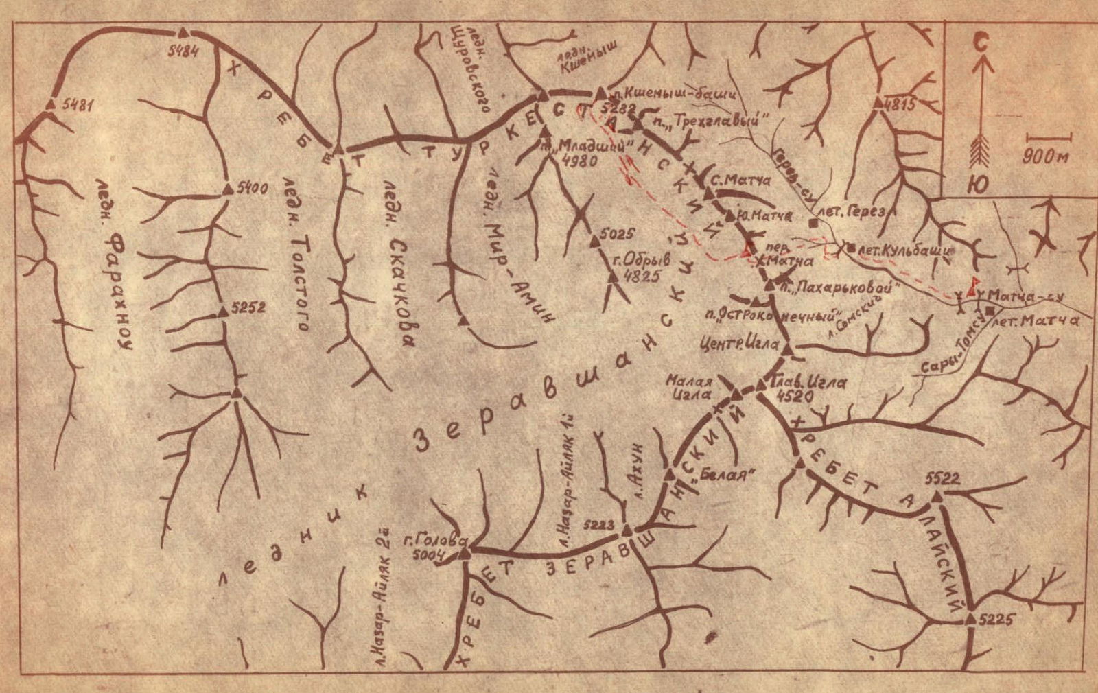
Peak Kshemysh Bashi (5110 m) is located in the Turkestan Range (Pamir-Alay) 5–6 km north of the Matcha Pass at the source of the Zeravshan Glacier. To the south of the peak, a ridge extends to the so-called Matcha node — the Iglá peak — the junction of three ridges: Alay, Zeravshan, and Turkestan. To the west, the main ridge continues with its numerous peaks and spurs. The northern and eastern slopes of the peak drop off onto the glaciers. In the immediate vicinity of Peak Kshemysh to the south lies Peak 4460 (Treхглавyy). To the west are two peaks about 5000 m high (the one closest to Peak Kshemysh will be referred to as the nodal peak). Both Peak Kshemysh and these two five-thousanders are clearly visible from the Matcha Pass. (Photo 1.)
In 1969, the Arzamas mountaineering section conducted a gathering in the area of the Matcha Pass. One of the ascent objectives for the most qualified group was Kshemysh.
Several logical ascent options are visible from the Zeravshan Glacier to Peak Kshemysh, which rises over a kilometer above the glacier:
- a) via the SSE ridge with ascent to the ridge along a wide snow-and-ice couloir-slope. This route is not more complicated than category 4A;
- b) from the W with ascent via a 150–200-meter sheer rock step to the saddle between the nodal peak and Kshemysh-Bashi and then along the western ridge — this is a category 5B route;
- c) via the southern wall — a category 5B route, but it is objectively dangerous: the wall is prone to rockfall, and large cornices on the summit ridge pose a threat of snow avalanches;
- d) via the western walls of the southwestern buttress — a category 5B route.
The choice of the last option was largely influenced by a large snow avalanche that occurred on the southern wall (option C) in the presence of the participants.
The group, consisting of Orlov N.I. (leader), Davydov A.P., Egorov L.A., Malykhin Y.M., Rudnev V.S., and Sofronov I.D. (members), set up a bivouac near the walls of Kshemysh-Bashi. From here, a visual selection of the ascent route was made. In outline, it looked like this:
- along the ice-and-snow slope of the western wall to a diagonal terrace;
- then along it to its upper part;
- the exit from the terrace to the ridge part of the route was only visible in its initial part through binoculars. It was clear that this exit was not straightforward;
- then along the ridge to the summit.
The descent was planned via the SSE ridge.
A backup ascent route was chosen along the wall of the vertical inner angle with an exit to the shoulder of the buttress. Here, as seen through binoculars, the path would be very challenging, but the presence of small ledges indicated normal passability in the initial part of the wall. Overcoming the upper part of the wall would obviously require significant effort and energy. The ridge part of the route remained unchanged.
On August 7, at 7:30 AM, the group began the ascent. They reached the bergschrund without roping up. The morning snow held well. They roped up in three teams under the shelter of the rock wall before the bergschrund:
- Davydov, Orlov;
- Rudnev, Safronov;
- Egorov, Malykhin.
They crossed the bergschrund in its right part via a small bridge. Then they ascended the snow slope bounded on the left by a sheer rock wall and on the right by a rock ridge. Next, they traversed a rock outcrop (rocks resembling "sheep's foreheads"). Above this outcrop, the slope turned from snow to ice. In its upper part, step-cutting was required. During the ascent, it was necessary to stay on the right (by direction) part of the slope as the left part had signs of rockfall.
They approached a small (4–5 m) wall in the upper right part of this section. The sheer wall was overcome on its right side, leading to a diagonal ledge with a slope of ~30°.
The rocks on the diagonal ledge were smoothed, resembling "sheep's foreheads."
Characteristics of the section:
- Few cracks for piton placement.
- Few ledges for intermediate belays.
In the upper part, there is a small (5–6 m) narrow passage where small stones and icicles frequently fall. The exit through this passage is not very complicated but requires attention due to possible rockfall.
Here, the diagonal ledge gives way to a wide (25 m) diagonal and inclined terrace.
The length of this section is about 120 m, with variable movement. Belays are via pitons and ledges.
Under the wall bounding the terrace on the right, we ascend leftward, initially over rocks, then over a very thin layer of rim ice, and approach a ~5-meter rock wall crossing the terrace.
Under the wall, there is some snow on the ice.
The rocks on the wall are covered with a layer of rim ice.
The exit to the upper part of the wall is very challenging.
The first person climbed the wall without a backpack.
Belays are via pitons.
Then, again along the junction of the terrace and the wall, we ascend. The steepness of the terrace increased to 40°. The rocks are smoothed. There are very few cracks for piton placement. Movement is alternating.
By 11:00 AM, we reached the base of the vertical inner angle (R7) — the point of final route choice. Further movement along the terrace was not appealing:
- the steepness of the smoothed rock slope was compounded by fine clay-like material;
- footing was unreliable;
- few cracks in the wall.
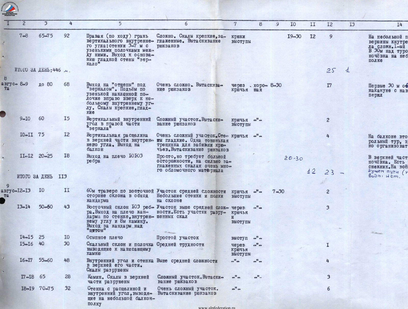
After a short reconnaissance of the terrace, rest, and discussion, we decided to proceed along the right face of the vertical inner angle. From this point onwards, the first person in the group climbed without a backpack.
The path immediately went upward along the wall with a small crevice. Here, the rocks were strong, although very steep. There were opportunities for belays and receiving teammates. 7–12-meter walls alternated with narrow ledges. On a small ledge ~80 m above R7, we constructed a control cairn. Further, ~40 m upward and to the right, we reached a narrow ledge at the base of a smooth, almost sheer wall.
Reconnaissance of the path around this wall along the ledge to the right was unsuccessful:
- the first person, after ~1 hour of challenging climbing, reached smooth sheers beyond the wall's bend;
- movement along the junction of the vertical angle's face was generally problematic, especially in its upper part near the "shield";
- here, movement was along a sheer face or overhang.
The only feasible path was under the base of the smooth wall along a small rock outcrop — a ledge. The exit to this outcrop from under the overhang (see photo) was very difficult and required more than 10 pitons to overcome. The rocks were smoothed, with very few holds. Movement was along a small crack using pitons.
The time was 5:00 PM. While the Davydov-Malykhin team processed the exit to the outcrop, the rest of the group began to prepare for the night on the ledge. By 8:30 PM, all six, attached to safety ropes, sat on the ledge to rest.
The night was windless, with warm rocks heated during the day. Unfortunately, there was no water. By morning, there was no more than 400 grams of water left in the flask for the entire group.
In the morning, the Malykhin-Orlov team ascended on the suspended rope to the end of the processed section and, after 1 hour and 30 minutes of further processing, reached the outcrop. Here, after placing 3–4 pitons, a reception point was established for the next team via a fixed rope, and for all backpacks.
The sun, illuminating the wall at 11:00 AM, was unbearably hot. There was no water. Further along a narrow (up to 15 cm) ledge, steeply ascending to the right, we reached a small inner angle leading to a narrow crevice at the junction of the vertical wall and the vertical right face of this angle.
The exit via the 12-meter vertical crevice to a balcony (P.11) in the upper right part of the wall was very challenging:
- Practically no holds.
- A small vertical crack for placing thin pitons ~1.5 m to the left of the crevice.
- It was very difficult to wedge feet in the crevice.
- Pulling up backpacks.
- Movement via fixed ropes.
Here, on the balcony, we established a second control cairn. From the balcony, bypassing the right side of the gendarme's wall, we reached an inclined shoulder of the SW buttress. On the shoulder, there was a small snow patch. Here, on the rocks of the shoulder, by 8:00 PM, we stopped for our second night, quickly arranging a comfortable platform.
We began the further ascent on August 9 at 7:30 AM, moving to the eastern slope of the buttress. After an almost 60-meter horizontal traverse along a steep rock slope with small ledges, we started climbing upward:
- initially along a wall;
- then along an inner angle and a chimney,
and reached the ridge beyond the gendarme. Here, climbing was not straightforward. Belays were through ledges and pitons.
After passing a short, straightforward section of the ridge beyond the gendarme, we again traversed a ledge to the eastern slope. Then we ascended via:
- rock walls;
- inner angles;
- ridges,
bypassing a vertical tower of the buttress on the right. Here, the most challenging section was a chimney and a 30-meter wall with a crevice. Overcoming these, we reached a small ledge — a balcony — and then the ridge. By 6:00 PM, the entire group assembled on the ridge. The path along the ridge did not present significant technical difficulties. Encountered gendarmes were generally bypassed on the right via small ledges. In a small depression of the ridge, we stopped for our third night at 9:00 PM.
On August 10, at 7:00 AM, we continued along the ridge. A relatively straightforward section of the ridge led to the wall of a large gendarme of the pre-summit tower (R26). This gendarme was bypassed on the left via a steep snow-and-ice couloir. The upper part of this couloir led to a heavily fragmented rock slope and then to a scree ridge, along which we reached the snowy summit ridges.
By 10:00 AM, the entire group was at the summit cairn, where we found a note from a sports group of the Novosibirsk Mountaineering Club "Vertikal" (led by Belyaev L.), who had reached the summit on July 25 via the NE ridge.
The descent route followed eastward along a heavily fragmented rock ridge. Upon turning the ridge to the south, we began descending the slope: initially over rocks, then down a steep ice slope (about 90 m), and finally along snowy slopes leading to the upper cirque of the Zeravshan Glacier to our bivouac.
At 2:20 PM, the observing group congratulated the ascenders on successfully completing the route.
The group spent 45 hours on the entire route. On the route, 77 rock pitons and two ice screws were placed. The most challenging sections of the route were:
- the exit from the terrace to the shoulder of the buttress (sections R7–R11);
On this section, there is no water, so the group needs to carry several flasks of water. Water might be available (in the case of a snowy winter) in the lower part of the terrace. The sun illuminates the walls at 11:00 AM. Heat and thirst significantly complicate the passage of this already challenging section.
- The second key section is the 30-meter chimney and wall with a crevice (section R19–R17) before reaching the main ridge.
Possible bivouac locations:
- balcony (P.11);
- shoulder of the SW buttress (P.12);
- a comfortable platform for bivouac on the saddle beyond the gendarme (P.14);
- many places along the ridge part of the route (sections R19–R26).
The group, in assessing the difficulty category of the completed route, relied on experience from previous ascents on classified routes.
The route to Peak Kshemysh Bashi via the W wall of the SW buttress is significantly more challenging than routes to Peak Shchurovskogo (via "Surka") — category 5B, Ullu-Tau Chana (central) from the north (via V. Abalakov's path through the "rhombus") — category 5B, Chatyn-Tau (via Garf) — category 5B.
It is not less challenging than routes to v. Tyutyu Bashi from the N (2nd tower via M. Kherman's path) — category 5B, p. Uzbekistan via the N wall (Alay Range, Dufba team) — category 5B.
The length of the most challenging sections on the route to Peak Kshemysh Bashi is not shorter than that of the mentioned classified routes, and the height of these sections on the classified routes (except for the route to p. Uzbekistan) is significantly lower than on the route to Peak Kshemysh Bashi.
Based on the experience of these ascents, the group evaluates the completed route as a category 5B route and requests the route commission of the USSR Mountaineering Federation to classify the route to Peak Kshemysh Bashi via the W wall of the SW buttress as category 5B.
Regarding the height of Peak Kshemysh Bashi: according to map markings, the height is 5223 m. According to the altimeter readings taken by the group, the summit height is 5110 m ± 25 m.
It should be noted that the actual heights of most peaks in this area (visited by the Arzamas gathering) are substantially lower than the heights indicated on the maps. For example, the height of v. Iglá according to maps is 5301 m. Actually, the height of the highest peak in the Iglá massif is 4510–4530 m, which cannot be attributed to altimeter error, especially since the altimeter's assessment of the Matcha Pass height (3780 m) practically coincides with its height on the maps (3800 m).
Main characteristics of the ascent route to v. Kshemysh Bashi (5110 m) via the western wall of the southwestern buttress:
- Elevation gain from Zeravshan Glacier: 1068 m
- Length of the most challenging sections: about 250 m
- Average steepness: about –70°
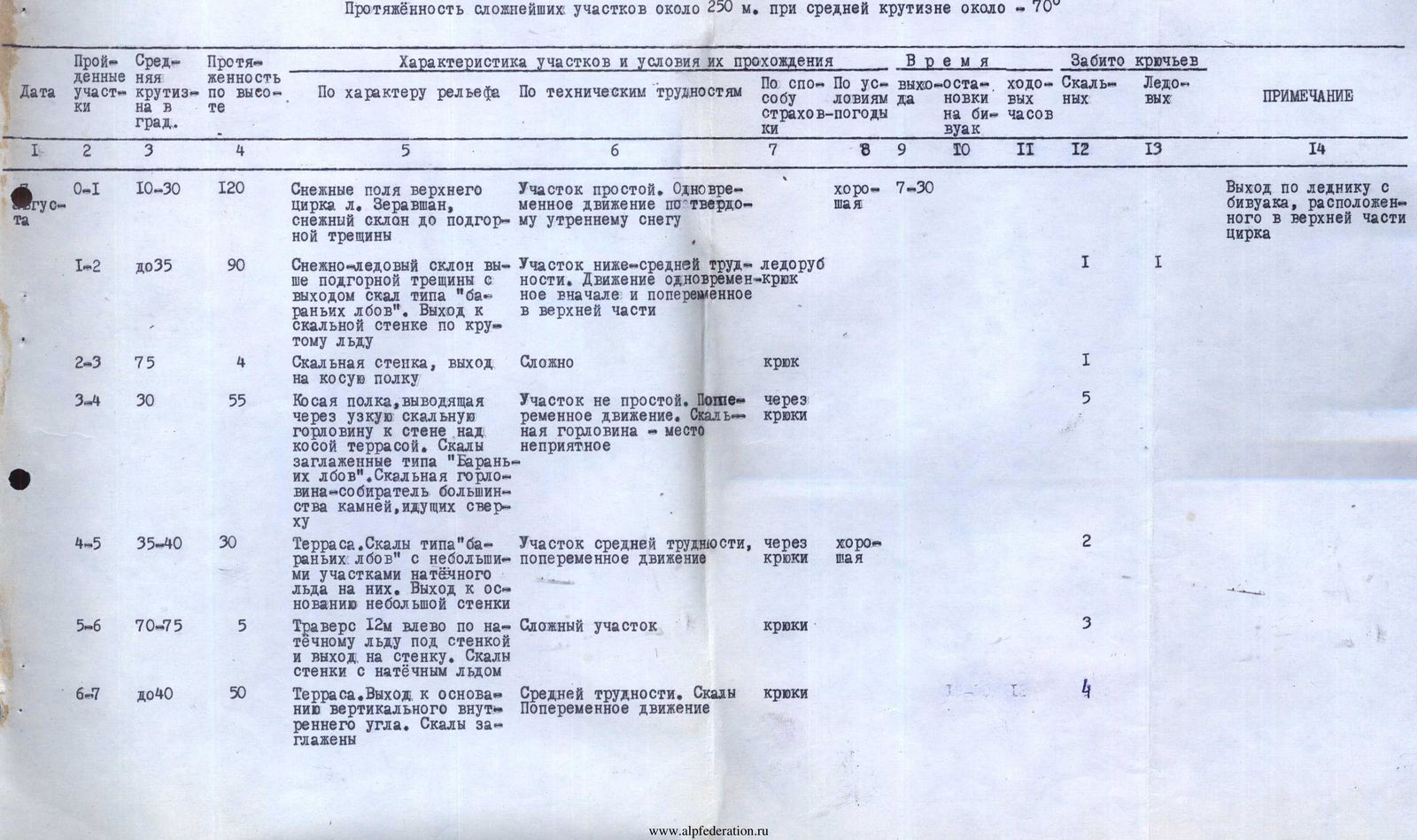
TABLE
| Date | Section # | Average steepness, ° | Height gain, m | Terrain characteristics | Technical difficulties | Belay method | Weather conditions | Exit/bivouac time | Climbing hours | Rock pitons | Ice screws | REMARKS |
|---|---|---|---|---|---|---|---|---|---|---|---|---|
| Aug 7 | R0–R1 | 10–30 | 120 | Snow fields of the upper Zeravshan Glacier cirque, snow slope to bergschrund | Simple section. Simultaneous movement on firm morning snow | — | good | 7:30 AM | — | — | — | — |
| R1–R2 | up to 35 | 90 | Snow-and-ice slope above bergschrund with rock outcrops resembling "sheep's foreheads." Exit to rock wall via steep ice | Section below average difficulty. Initially simultaneous, then alternating movement | Ice axe, piton | — | — | 1 | 1 | — | — | |
| R2–R3 | 75 | 4 | Rock wall, exit to diagonal ledge | Challenging | Piton | — | — | 1 | — | — | — | |
| R3–R4 | 30 | 55 | Diagonal ledge leading through narrow rock passage to wall above diagonal terrace. Rocks smoothed like "sheep's foreheads." Rock passage — collector of most falling rocks | Not a simple section. Alternating movement. Rock passage — unpleasant spot | Pitons | — | — | 5 | — | — | — | |
| R4–R5 | 35–40 | 30 | Terrace. Rocks like "sheep's foreheads" with small areas of rim ice. Exit to base of small wall | Average difficulty. Alternating movement | Pitons | good | — | — | 2 | — | — | |
| R5–R6 | 70–75 | 5 | Traverse 12 m left along rim ice under wall and exit to wall. Rocks on wall with rim ice | Challenging section | Pitons | — | — | — | 3 | — | — | |
| R6–R7 | up to 40 | 50 | Terrace. Rocks smoothed | Average difficulty. Rocks. Alternating movement | Pitons | — | 3:00 PM | 12 | 4 | — | — | |
| Aug 8 | R7–R8 | 65–75 | 92 | Right (by direction) face of vertical inner angle: 3–7 m walls with narrow ledges between. Exit to base of smooth "mirror" wall | Challenging. Strong, smoothed rocks. Pulling up backpacks | Pitons, ledges | — | 7:30 PM | 12 | 9 | — | 1st control cairn on small ledge at top of inner angle. Sitting bivouac on small ledge 30 m above cairn |
| Total for day | — | 446 | — | — | — | — | — | 25 | 1 | — | — | |
| R8–R9 | up to 80 | 68 | Exit to "outcrops" under "mirror." Ascent along narrow inclined ledge rightward to small inner angle. Strong, smooth rocks | Very challenging. Pulling up backpacks | Pitons | good | 8:30 AM | — | 17 | — | First 30 m processed the previous day with fixed ropes | |
| R9–R10 | 60 | 15 | Vertical inner angle in right part of "mirror" | Challenging section. Pulling up backpacks | Pitons, ledges | — | — | — | 2 | — | — | |
| R10–R11 | 75 | 12 | Vertical crevice in upper part of inner angle. Exit to balcony | Very challenging section. Smooth walls. One thin crack for piton. Pulling up backpacks | Pitons | — | — | — | 4 | — | 2nd control cairn on balcony; possible bivouac | |
| R11–R12 | 20–25 | 18 | Exit to shoulder of SW buttress | Simple but requires caution on highly smoothed rocks with much debris | — | — | 8:30 PM | — | — | — | Bivouac on shoulder's upper part. Small snow patch. No water on entire previous path (P.P. R7–R11). | |
| Total for day | — | 113 | — | — | — | — | — | 12 | 23 | — | — | |
| Aug 9 | R12–R13 | 10 | 11 | 60 m traverse along eastern slope, bypassing gendarme | Average complexity. Small walls and ledges on slope | Pitons, ledges | — | 7:30 AM | — | 2 | — | — |
| R13–R14 | 50–50 | 43 | Eastern slope of SW buttress. Exit to gendarme's shoulder via wall, inner angle, and 8 m chimney. Exit beyond gendarme above "shield" | Above average complexity. Sections with fragmented rocks | Pitons, ledges | — | — | — | 3 | — | — | |
| R14–R15 | 25 | 10 | Scree shoulder | Simple section | Ledges | — | — | — | 1 | — | — | |
| R15–R16 | 40 | 30 | Rock slope and ledge leading to overhanging rock | Average difficulty | Pitons, ledges | — | — | — | 4 | — | — | |
| R16–R17 | 55–60 | 48 | Inner angle and wall in upper part. Rocks fragmented | Above average complexity | — | — | — | — | 3 | — | — | |
| R17–R18 | 65 | 28 | Chimney. Rocks fragmented in upper part | Challenging section. Pulling up backpacks | — | — | — | — | 6 | — | — | |
| R18–R19 | 70–75 | 32 | Wall with crevice and inner angle leading to small balcony | Very challenging section. Pulling up backpacks | — | — | — | — | — | — | — | |
| Aug 10 | R19–R20 | 50 | 12 | Exit to ridge via rock slope | Not challenging. Alternating movement | Ledges | good | — | — | — | — | — |
| R20–R21 | 15 | 14 | Movement along wide rock ridge to gendarme | Simple. Simultaneous movement | — | — | — | — | — | — | — | |
| R21–R22 | up to 50 | 34 | Overcoming gendarme, wall, and then slope with fragmented rocks leading to monolithic gendarme | Average difficulty. Alternating movement | Pitons, ledges | — | — | — | 3 | — | — | |
| R22–R23 | up to 40 | 26 | Bypassing monolithic gendarme on left. Overcoming 3 m wall and then scree couloir | Not difficult. Requires caution in couloir. Alternating movement | — | — | — | — | 1 | — | — | |
| R23–R24 | up to 50 | 46 | Exit to ridge via eastern slope. Small walls and balconies | Average complexity | — | — | — | — | — | — | — | |
| R24–R25 | 10–30 | 35 | Path along ridge. Large block rocks, then small snow-and-ice saddles between gendarmes | Average and below average difficulty. Alternating or simultaneous movement | — | — | 9:00 PM | — | — | — | Bivouac on ridge | |
| Total for day | — | 377 | — | — | — | — | — | 13 h 30 min | 23 | — | — | |
| R25–R26 | up to 15 | 30 | Path along ridge to large pre-summit gendarme | Not challenging. Alternating or simultaneous movement | Ledges, bends | — | 7:00 AM | — | — | — | — | |
| R26–R27 | up to 40 | 82 | Ascent via snow-and-ice couloir (bypassing large gendarme), then fragmented rock couloir. Exit to scree shoulder | Above average difficulty. Requires caution due to "live" rocks. Alternating | Pitons | — | — | — | 4 | — | — | |
| R27–R28 | up to 20 | 20 | Scree slope leading to summit | Simple. Simultaneous movement | — | — | — | — | — | — | At summit by 10:00–10:30 AM | |
| Total to summit | — | 132 | — | — | — | — | — | — | — | — | Descent started at 10:30 AM | |
| R28–R29 | up to 30 | 140 | Heavily fragmented eastern ridge | Average difficulty. Partly simultaneous | Ledges | — | — | — | — | — | — | |
| R29–R30 | up to 50 | 150 | S slope of eastern ridge. Rocks fragmented | Average difficulty. Alternating movement | Ledges, piton | — | — | — | 2 | — | — | |
| R30–R31 | 45–50 | 210 | Descent along eastern slope: steep ice, then snow to rock island | Average difficulty. Fixed ropes | Pitons, ice axe | — | — | — | — | 1 | — | |
| R31–R32 | 30–10 | rest | Exit to upper Zeravshan Glacier cirque via rock island and snowy fields to bivouac | Not challenging | — | — | — | — | — | — | — | |
| Total for ascent to summit | — | — | — | — | — | — | — | 40 climbing hours | 75 | 1 | — | |
| Total for entire route | — | — | — | — | — | — | — | 45 climbing hours | 77 | 2 | — |
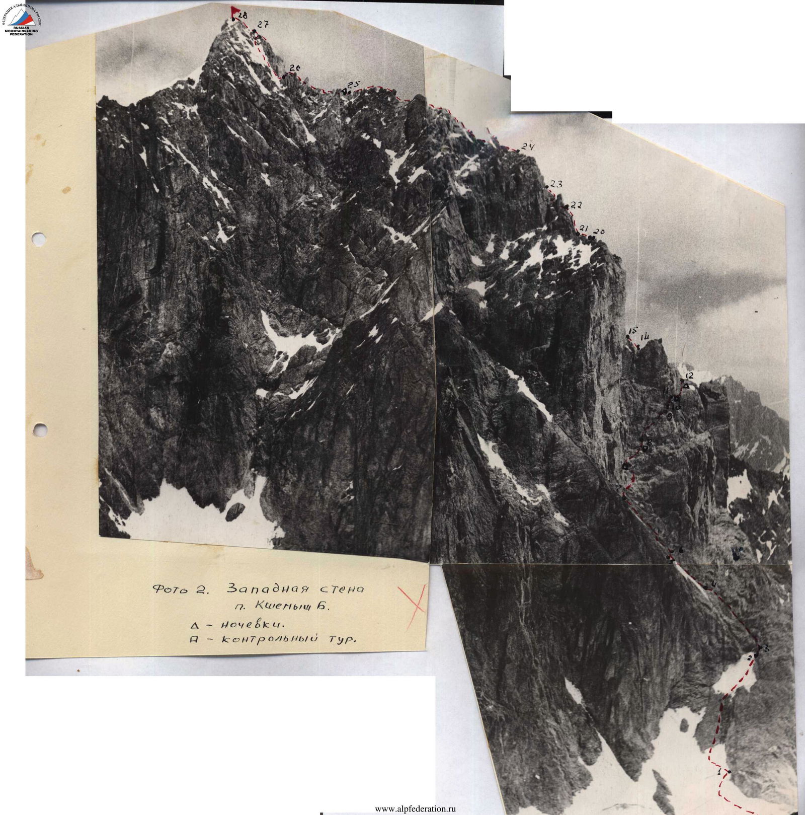
Photo 2. Western wall of p. Kshemysh B. Δ — bivouacs. P — control cairn.
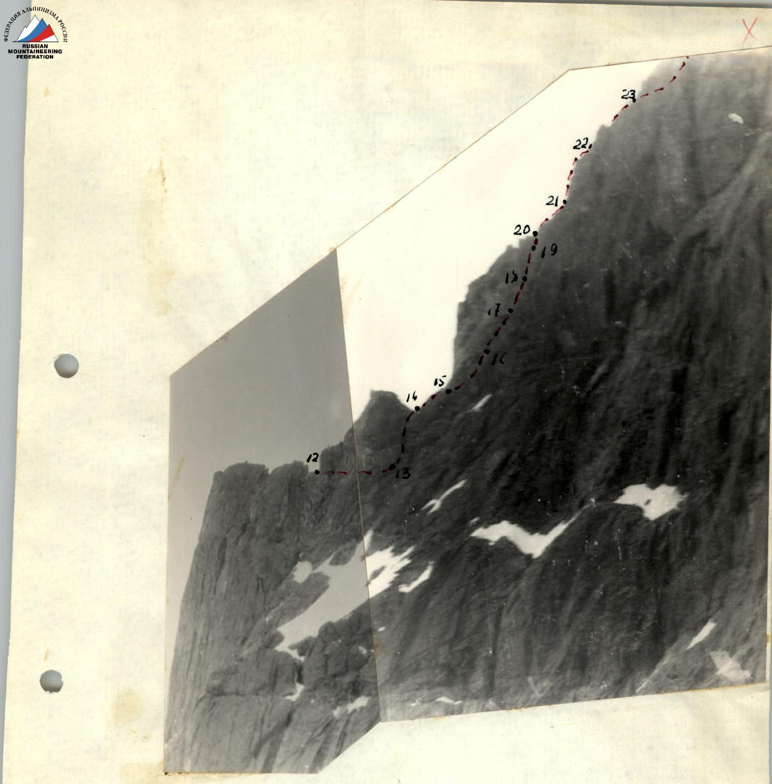
Photo 3. View of the ridge of p. Kshemysh B. from the east.

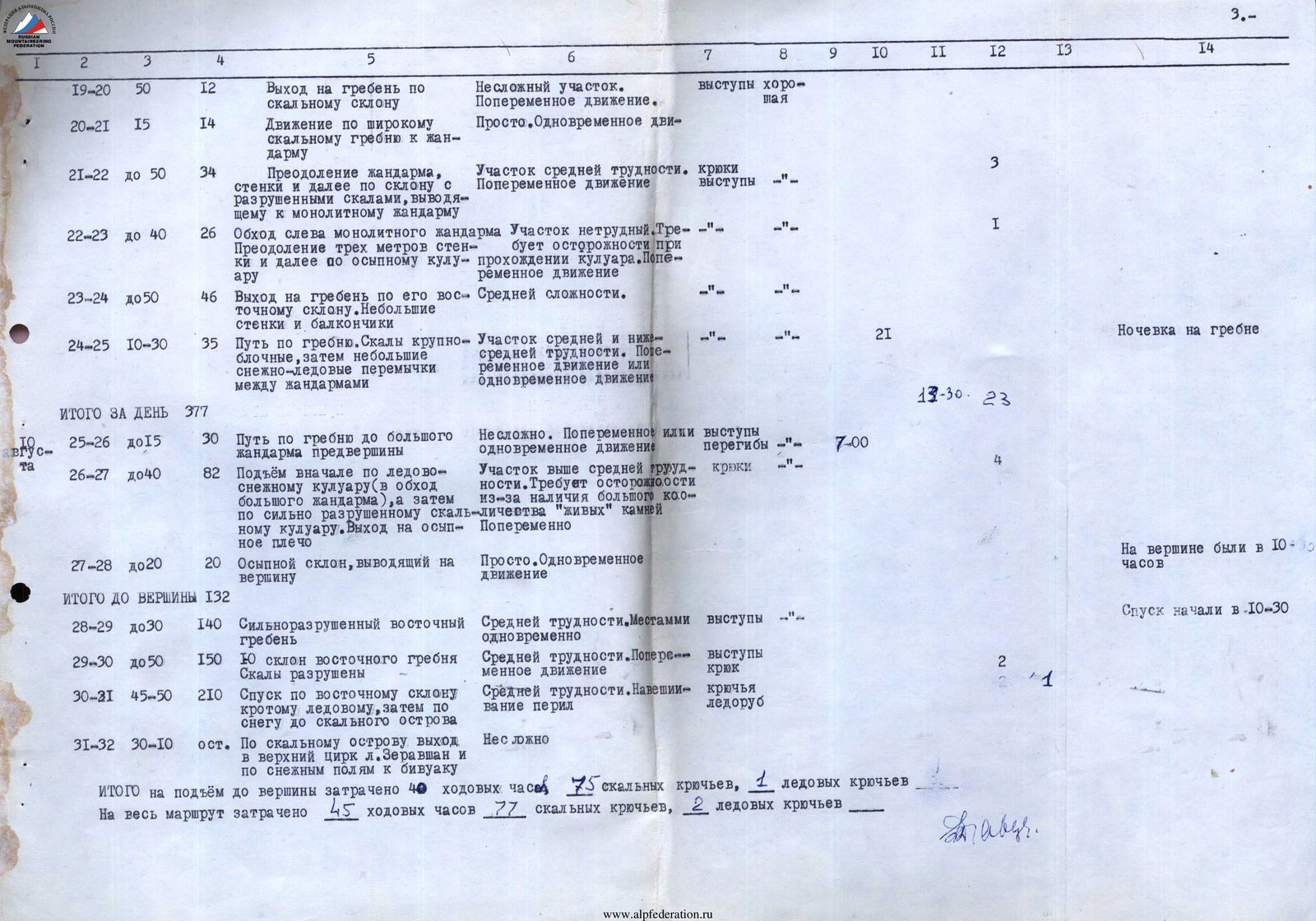
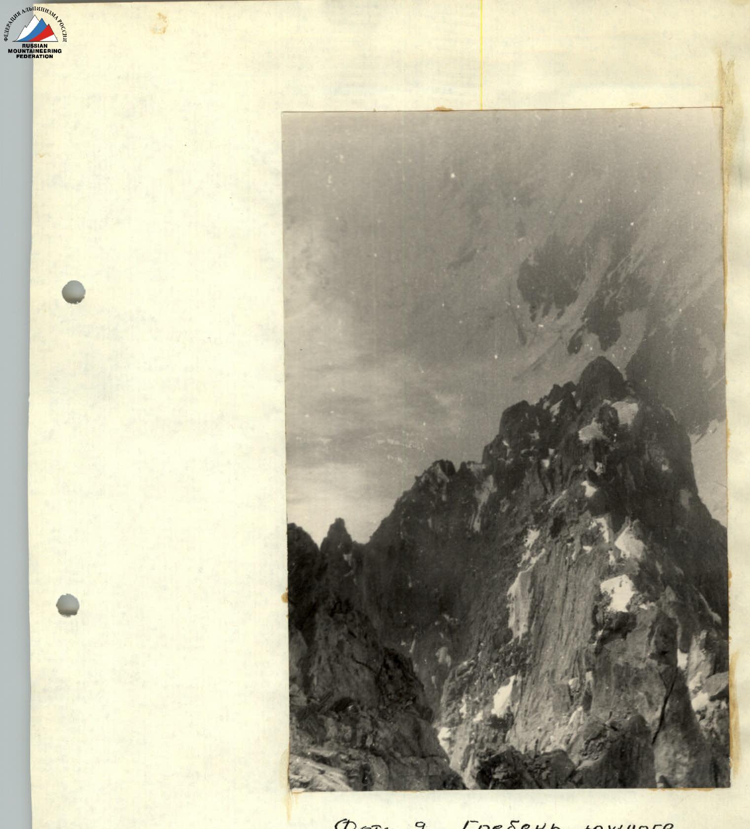
Photo 9. Ridge of the southern buttress of p. Kshemysh B. From P. 25 to P. 24.