Description of the Ascent Route to Peak 4350 "Malaia Igla" via the Southeast Ridge
/First ascent/
Group Composition:
- Rudnev V.S. — leader
- Malykhin Yu.M. — coach
- Egorov L.A.
- Zhelonkin E.F.
- Pavlovsky E.S.
- Sofronov I.D.

Peak 4350 "Malaia Igla" is located in the upper reaches of the Zeravshan glacier (Pamir-Alay), in the northern part of the Zeravshan Range. To the north of it lies the junction of the Alay, Zeravshan, and Turkestan Ranges — the peak Igla (later found to be a massif of entirely separate peaks, conditionally named — Pahar'kova Peak, Central Igla, and Main Igla). To the south of peak 4350 lies peak Belaya — 5000 m. The height of "Malaia Igla" was determined using an altimeter with an accuracy of ±20 m. The name was proposed jointly with the Khokhryakov group, which made the first ascent of the peak via the Southwest edge on July 20, 1969 (see map diagram fig. 1 and photos 1 and 2). The group from Arzamas 16, consisting of: Rudnev V.S. — leader, Malykhin Yu.M. — coach, Egorov L.A., Zhelonkin E.F., Pavlovsky E.S., Sofronov I.D. — members, having preliminarily assessed the ascent route to Malaia Igla via the southeast ridge as category 4A, made the first ascent of this route on July 20, 1969 (see photos 3 and 4). The group left the base camp at Matccha pass at 7:00, reached the summit at 16:30, and returned to the bivouac at 20:30 the same day. From Matccha pass, the path leads left — down to the Zeravshan glacier, bypassing the southern ridge of Ostrokonechny peak, then up to the snow-ice plateau under the southern slopes of Igla (caution — crevasses! It is necessary to move in rope teams) and bypassing the southwest edge of Malaia Igla to the pass, conditionally named "Karniz" (see photos 1, 2, 5). The pass is a short snowy slope 50–55° with a height gain of 50–60 m. At the bottom and middle parts, there are small bergschrunds; at the top, there is an 8–10 m rock exit of the same steepness. To the left, an ice screw is hammered into the rocks. The path from the base camp to the pass takes 1.5–2 hours, crossing the pass takes 0.5 hours.
The exit to the ridge is the 1st key section of the route. It is a tower with indistinct walls or the first gendarme (see photo 3). It is bypassed to the right by a traverse of 80 m along a snowy slope of 40–50°, increasing in steepness to an indistinct crest extending to the east. Belay via ice axe. Ascent along the ledges upwards 60–70 m. The rocks are of medium-block structure, medium difficulty, with a steepness of 50–55° (see photo 6). Belay is alternating via protrusions. The crest degenerates into a 10-meter wall with a steepness of 75°. In its lower left part, a screw is hammered. Exit to the right-upwards 3–4 m — 2nd screw. Further, straight upwards under a large triangular protrusion — belay via it (rappel). To the summit of the gendarme straight upwards 40–60 m of climbing of medium difficulty with alternating belay. At the summit — a control cairn. Height gain — 120 m, average steepness 55–60°, ascent from the pass — 2 hours 30 minutes.
From the 1st gendarme to the 2nd leads a steep snowy saddle, with rocks on the eastern slope covered in places with flow ice, and cornices on the western slope (see photo 7). The first 10–15 m are passed with careful belay. The 2nd gendarme is bypassed to the right, and then upwards along a snowy 45–50° ascent 10–15 m (see photo 8). Between the 1st and 2nd gendarmes 80–90 m. Then 80 m of rock ridge of medium complexity to the 3rd gendarme. Belay via protrusions, sometimes simultaneous. The 3rd gendarme is represented by large, overhanging "feathers" of rocks. It is overcome head-on with a move to the left into a 5-meter crevice between the "feathers". Further, a rocky ridge 50 m to the base of the 4th gendarme. Movement is simultaneous (see photo 9). The second key point of the route — the 4th gendarme is bypassed to the right along ledges 40 m with careful piton belay (live rocks!). A variant of passing the gendarme head-on is possible, but in this case, it is necessary to overcome a 2.5-meter overhanging wall. On the 4th gendarme — the second control cairn. Then 50–60 m of alternating movement along a snowy crest to the pre-summit ascent. Move left and up along a 13-meter wall with a steepness of 65°. Climbing is above medium difficulty. To the base of the summit tower 45–50 m of rocky crest of medium difficulty. The height of the tower is 15–20 m, steepness 75–80°. Climbing is complex, belay is via pitons. This is the third key section of the route, passed straight upwards (see photo 10). The summit — a small rocky platform.
Descent to the east — first a rappel 15–20 m, then sports climbing down heavily destroyed ledges of an indistinct couloir. Further along the glacier to Karniz pass and to the base camp.
Thus, the ascent to Malaia Igla via the southeast ridge is a combined route. From Matccha pass to the summit — 9 hours 30 minutes, descent and return to the base camp — 4 hours. Height gain from Karniz pass — 200 m.
Key Sections:
- 1st gendarme
- 4th gendarme
- summit tower
7 rock pitons were hammered. There are no good places for overnight stay on the route. If necessary, descent from the ridge to the glacier along the eastern slope is possible.
When assessing the category of complexity of the route, the group members, all having ascents of category 5, proceeded from their experience of climbing classified routes. This route:
- is technically more complex than the ridge routes: Sarykol (3B, Adyr-Su), MNR (3B, Traverse, Baksan), Kichkidar-Yunom (3B, Adyr-Su);
- is not inferior to: Nakra-tau via the NE buttress (4A, Baksan), 1st tower of the Crown (4A, Kyrgyz Ala-Too), Ullu-tau-chana (4A, Adyr-Su);
- is similar in complexity and character to Adyr-Su from Granovsky (4A, Adyr-Su).
Based on this, the group proposes to classify the ascent to peak 4350 "Malaia Igla" via the southeast ridge as a category 4A route.
Recommendations for Climbers:
- Number of participants — 4–6 people.
- Initial bivouac — Matccha pass.
- Departure time — 3–4 hours.
- Equipment: main rope 2×40 m, auxiliary cord 6–8 m, rock pitons 6–8, ice screws 1–2, rock hammer — 2, carabiners — 8, tent — 1.
November 13, 1969
Rudnev
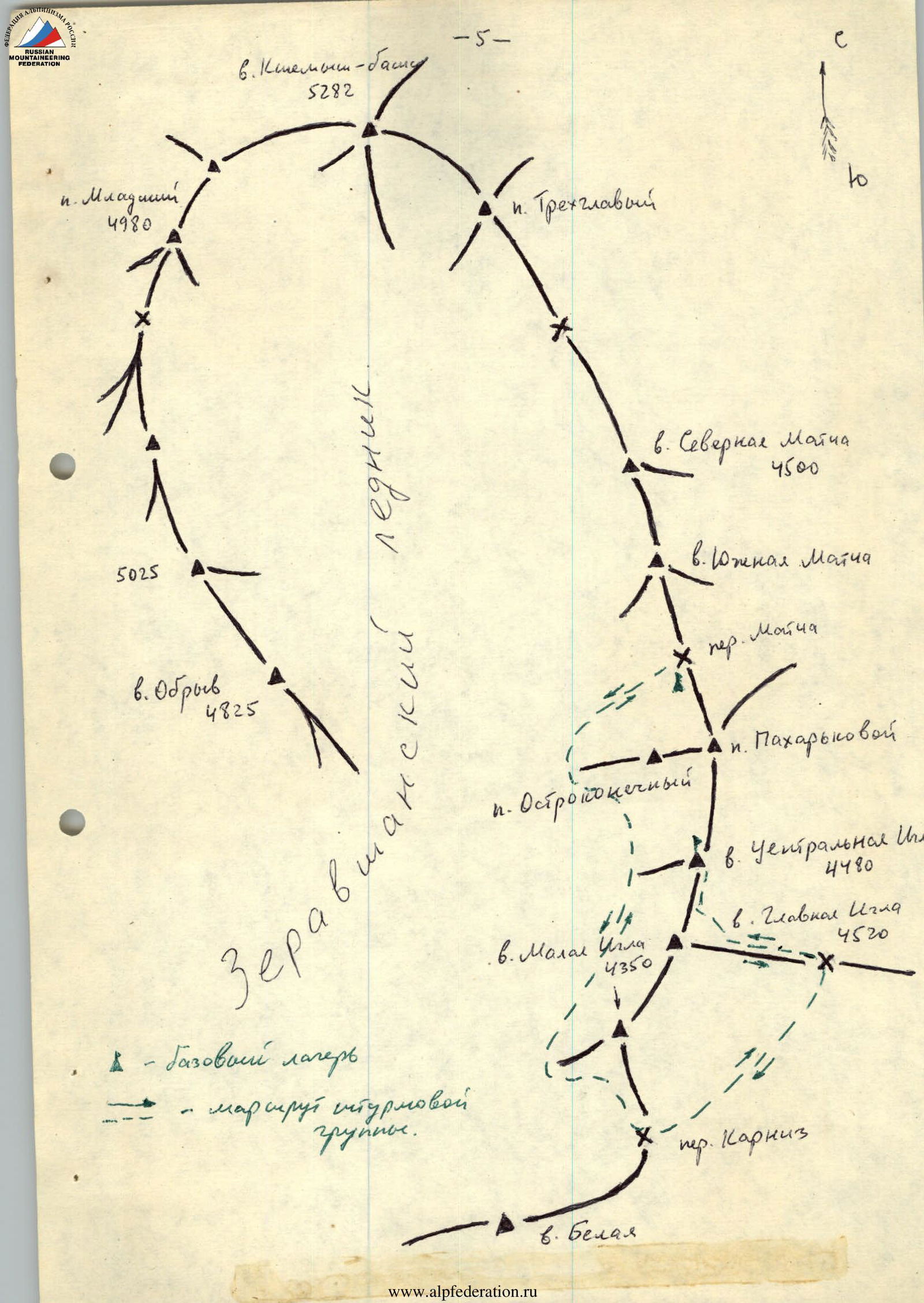
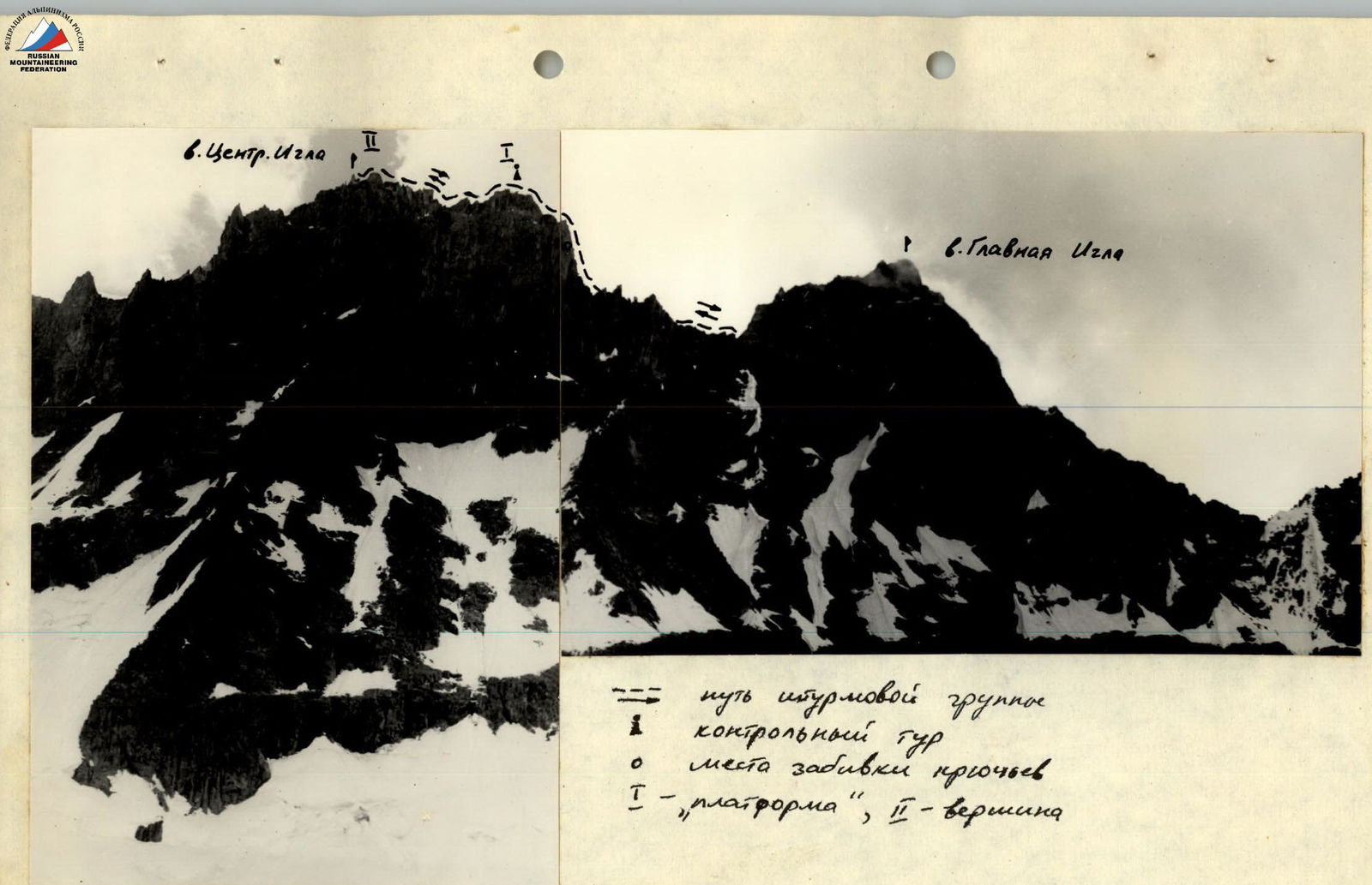
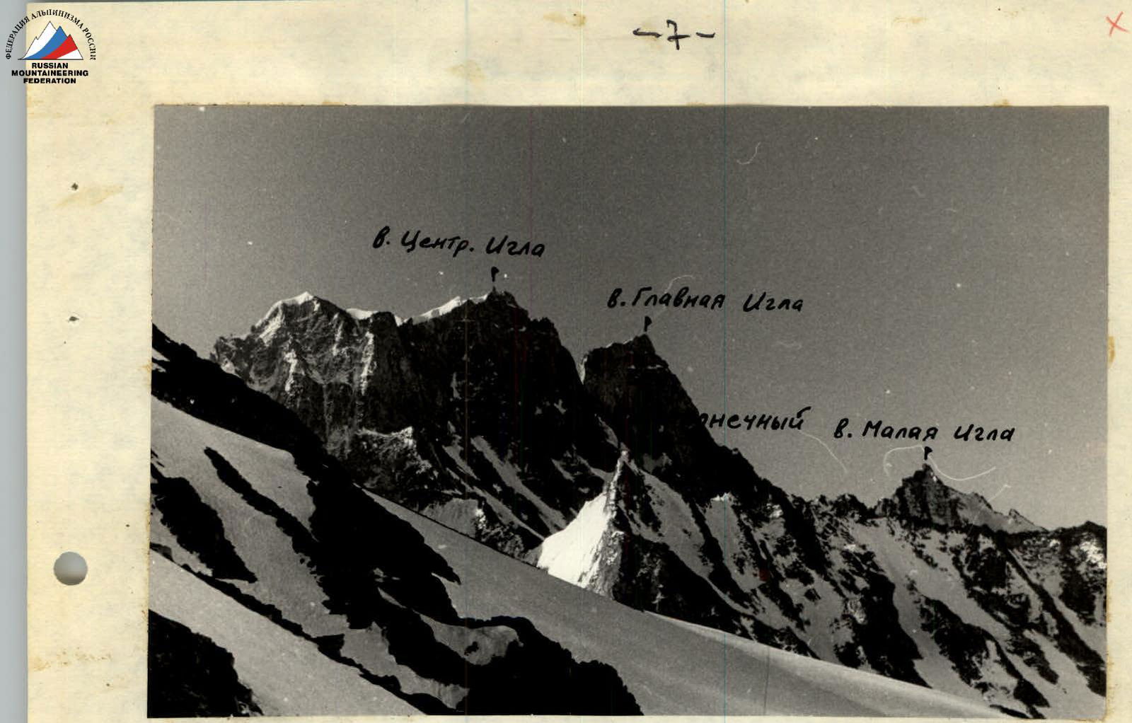
Photo 1. View of the Igla massif from Matccha pass.
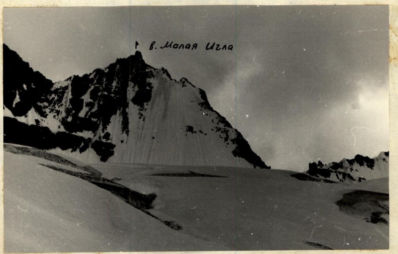
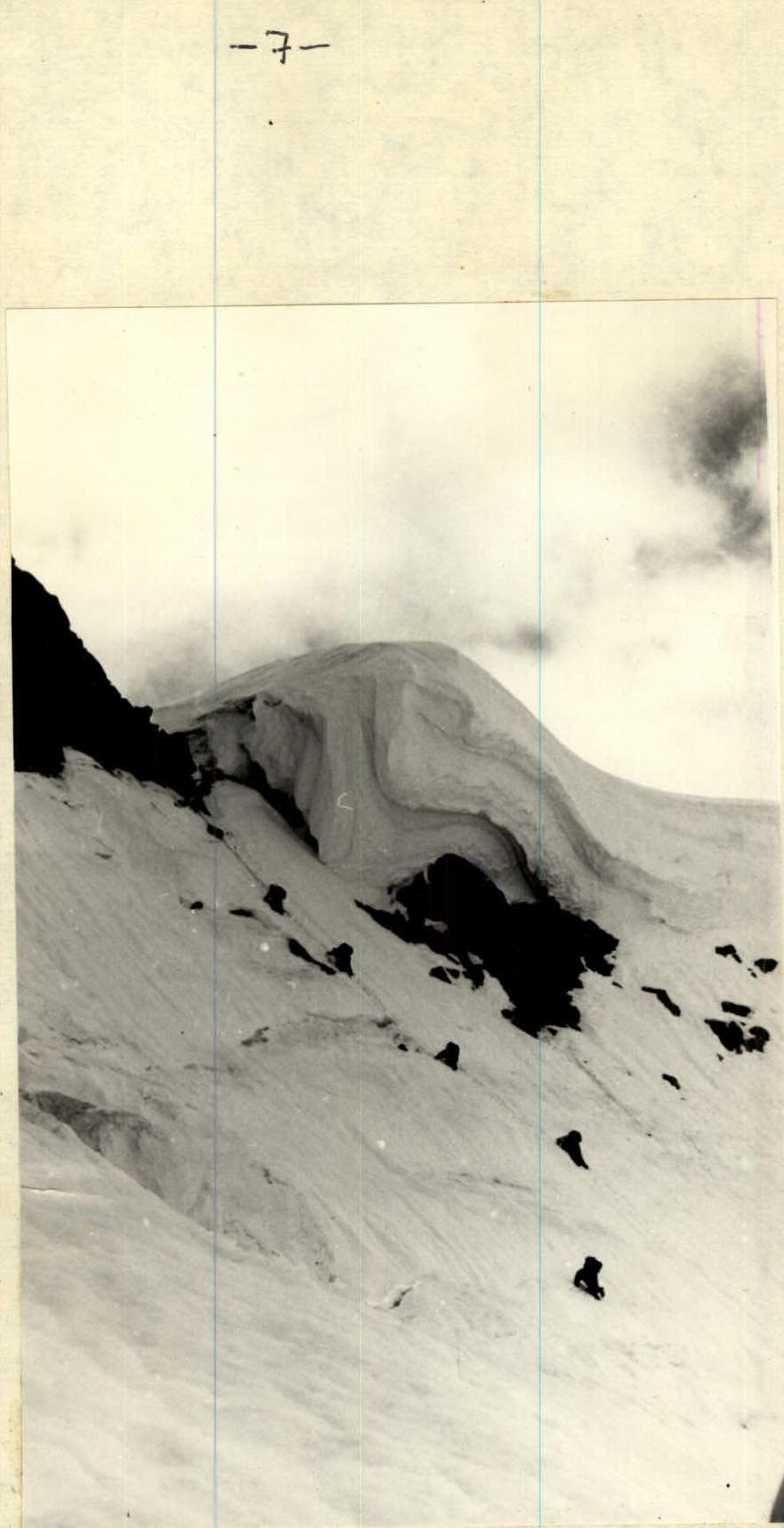
Photo 2. Karniz pass. I, II, III, IV — gendarmes, V — summit.
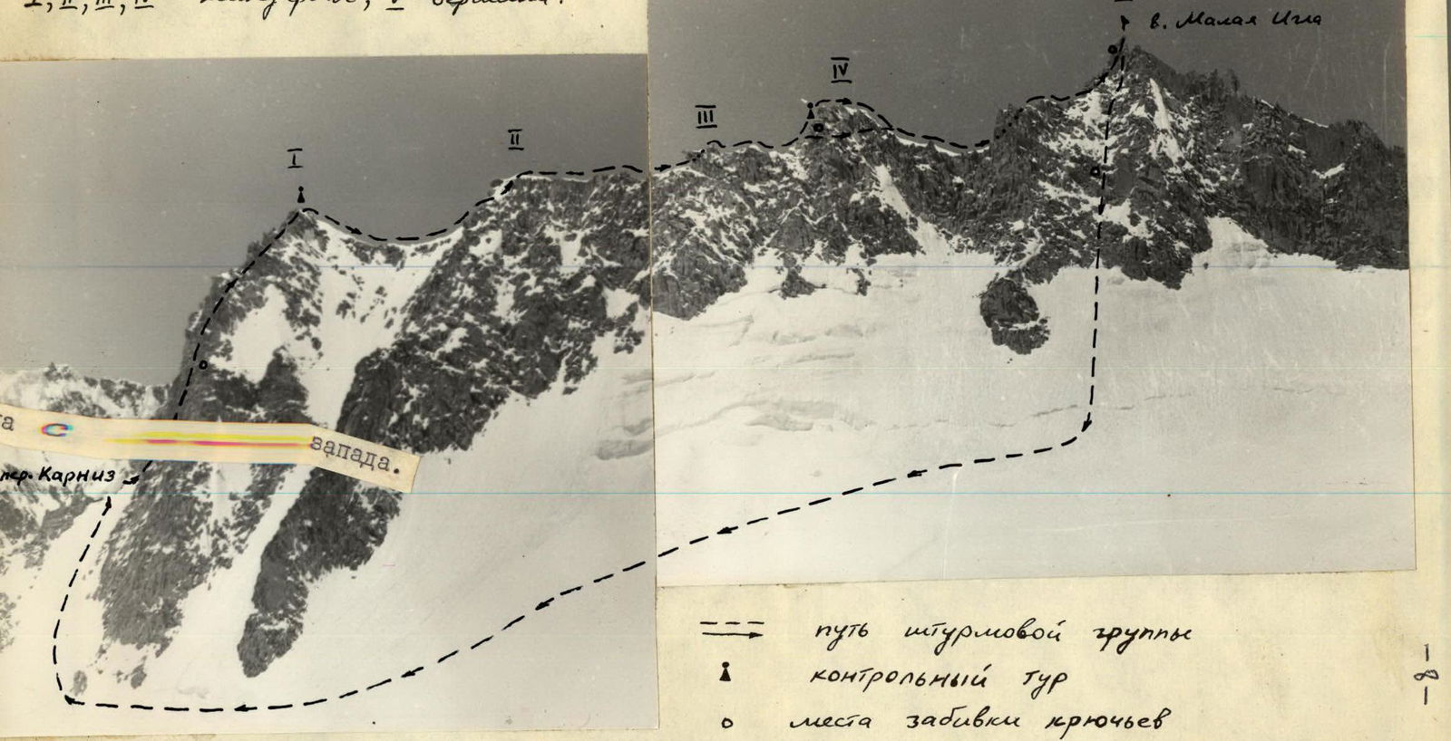
Photo 3. View of the southeast ridge of Malaia Igla from the east.
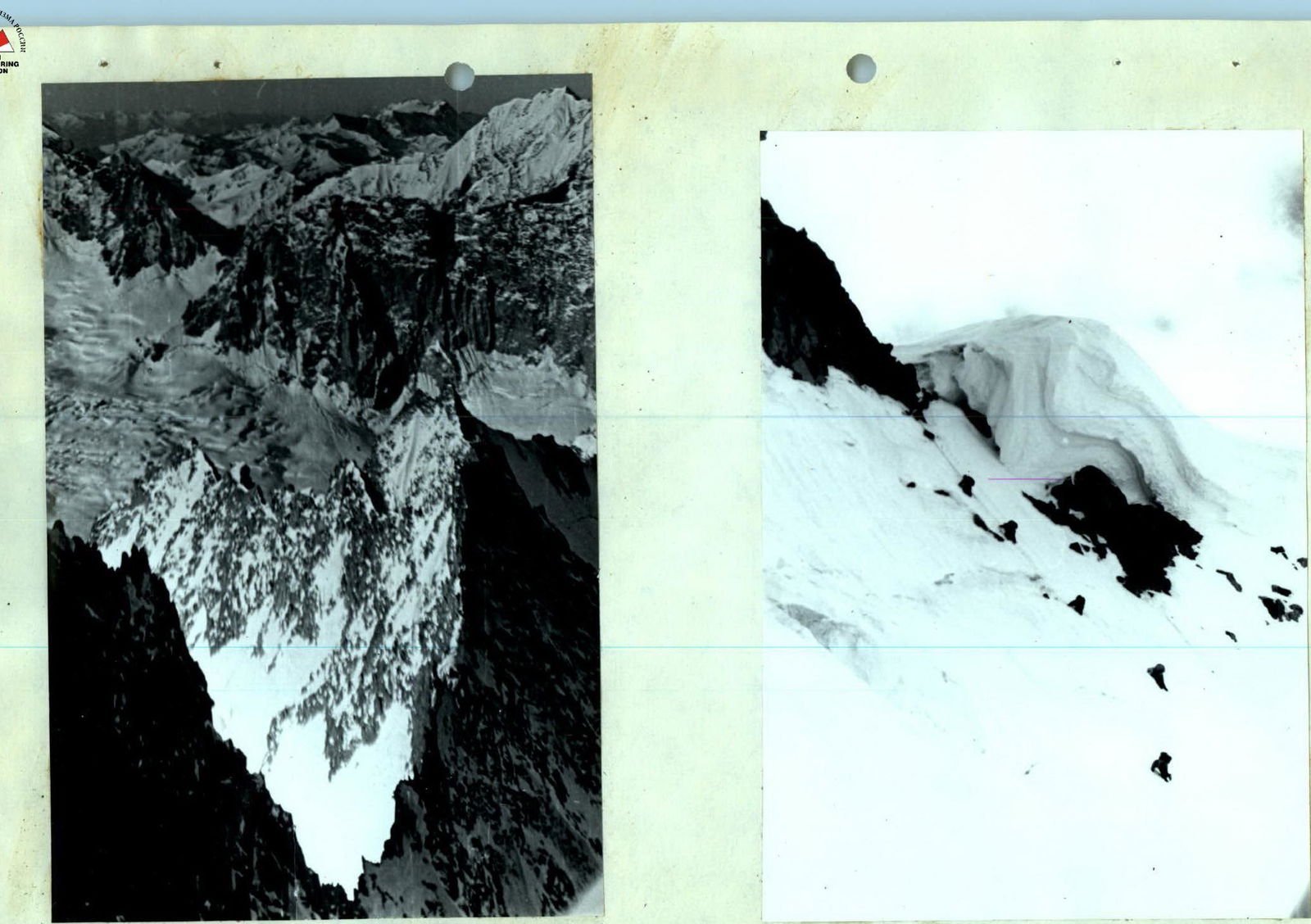
Photo 4. View of the southeast ridge of Malaia Igla from the ridge of Central Igla.