
DESCRIPTION OF THE ASCENT ROUTE TO THE "GLAVNAYA IGLA" SUMMIT VIA THE SOUTHEAST SLOPE. 1969
Group composition: GLADILIN L.S. (leader), RUDNEV V.S., ABLESIMOV V.E., GITERMAN B.P.
The Iglá summit is located in the Pamir-Alay mountains, at the junction of the:
- Alay range,
- Turkestan range,
- Zeravshan range
(see diagram 1).
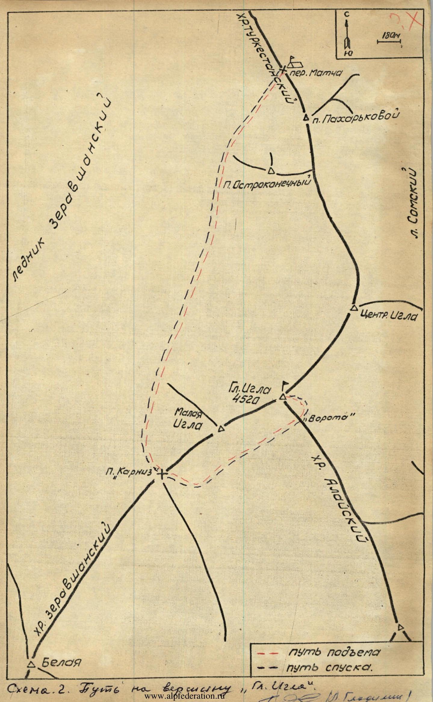
The Iglá summit (see diagram 2, photo 1) is a massif consisting of three peaks, conditionally named:
- Pik Pakharkova (1),
- Tsentralnaya Iglá (2),
- Glavnaya Iglá (3),
respectively located from northwest to southeast. Northwest of the Iglá massif lies the Matcha pass. The height of "Glavnaya Iglá" is 4510 m, determined by altimeter with an accuracy of ±20 m.
The group from Arzamas-16 gathering, consisting of:
- Gladilin L.S. - leader,
- Rudnev V.S.,
- Ablesimov V.E.,
- Giterman B.P.
made the ascent via the southeast slope on August 3, 1969.
The group left the base camp on the Matcha pass at 3:00 and was at the summit at 19:20, and returned to the base camp at 16:00 on the same day. From the Matcha pass, the path goes down and to the left onto the Zeravshan glacier, bypassing the southern ridge of the "Ostrokonetchný" peak and emerging onto a snow-ice plateau (see diagram 2). Here, it is necessary to move in a rope team, as there are crevasses.
Then, rounding the southwest edge of the "Malaya Iglá" peak, the path goes to a pass, conditionally named "Karniz" (see photo 1). The journey to the "Karniz" pass takes about 1 hour 30 minutes. From here, the ascent begins.
The "Karniz" pass is initially a snowy, then rocky slope with a steepness of 45–50° and a height gain of about 70 m. At the bottom and in the middle part of the path to the pass, there are bergschrunds, and in the upper part - rocks 8–10 m of the same steepness. The ascent to the pass must be done with alternating belay. The ascent to the pass takes 30 minutes. From the pass, the path with a slight descent leads to a snow field, which is crossed in a northeast direction towards a gap between the southeast wall of Glavnaya Iglá and a ridge of rocks extending to the southeast. This gap is conditionally named "Vorota" (see photo 1). The journey from the "Karniz" pass to "Vorota" takes about 1 hour.
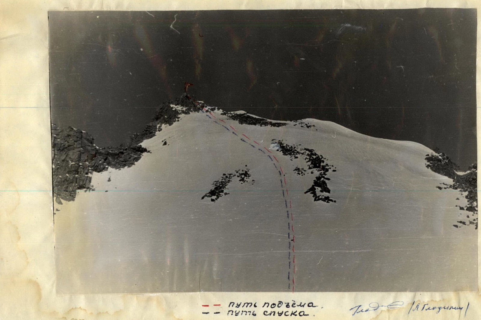
The remaining part of the route (see photo 2) goes along a snowy slope with varying steepness from 15° to 40°. Some sections of the slope are avalanche-prone. The last 10 m of the path are simple rocks. The southwest part of the summit drops off with a sheer wall. At the summit, a note was found, left by a group of climbers led by Rototaev K., who made the ascent to the "Glavnaya Iglá" summit on October 1, 1968.
After the ascent, the "Glavnaya Iglá" summit was rated by the participants as category 2B difficulty.
When assessing the difficulty category of the route, the group drew on their experience of ascending the:
- Latcga (from Gorvash pass)
- Tyutyu-Bashi (3rd tower)
- Kichkidár summits. All these peaks are located in the Caucasus. The route to the Glavnaya Iglá summit is no easier than the above-mentioned ones.
Recommendations for climbers.
- Number of participants - 4-8 people.
- Initial bivouac - Matcha pass.
- Departure time - 2-3 hours.
- Equipment - main rope 3×40 m, expendable rope - 2 m, ice screws - 1, hammer - 1.
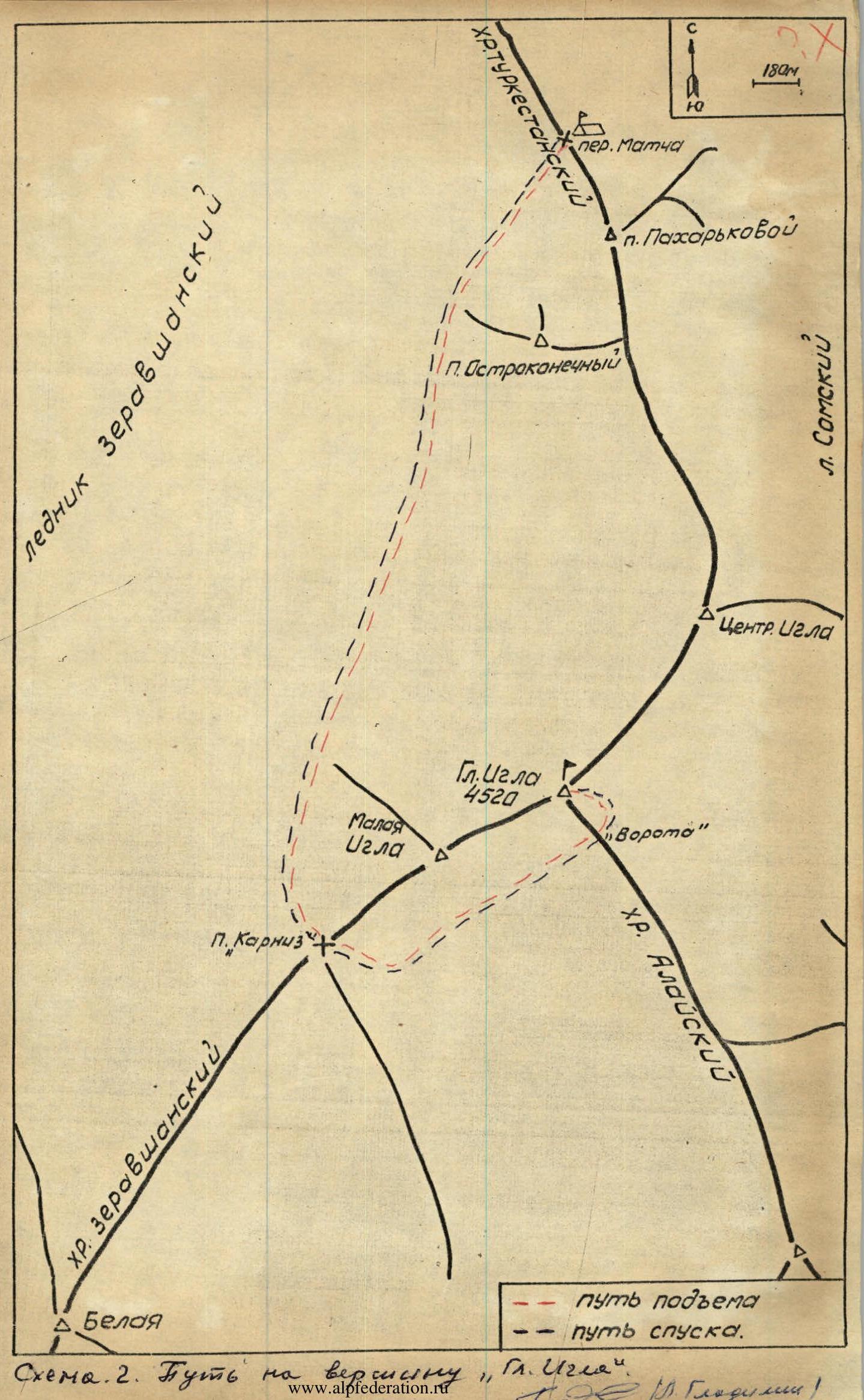
 -- ascent path
-- descent path
-- ascent path
-- descent path
-- ascent path
-- descent path
.... invisible path


Comments
Sign in to leave a comment