Ascent Passport
- Ascent class — technical
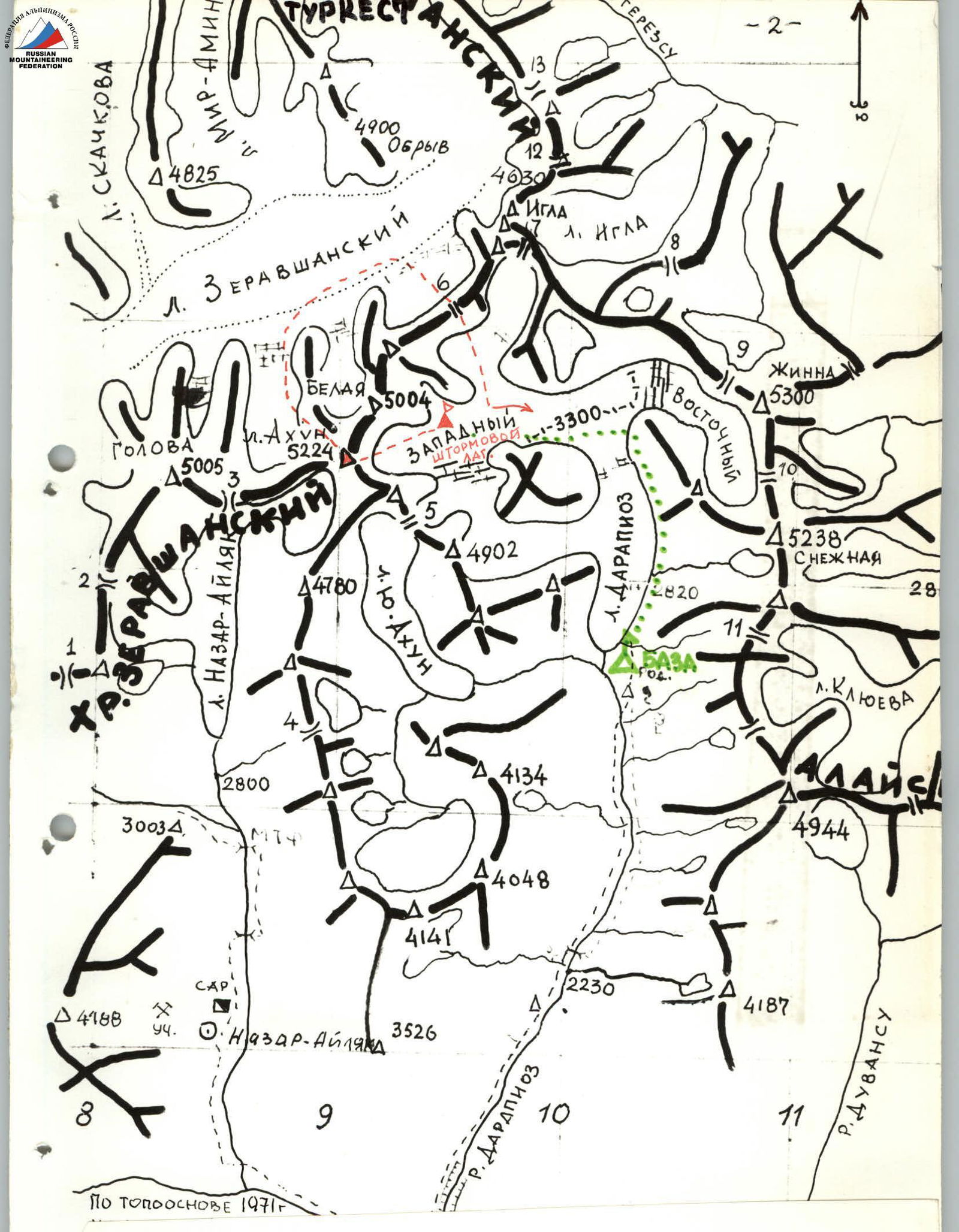
- Ascent area — Pamir-Alay, Zeravshan Range
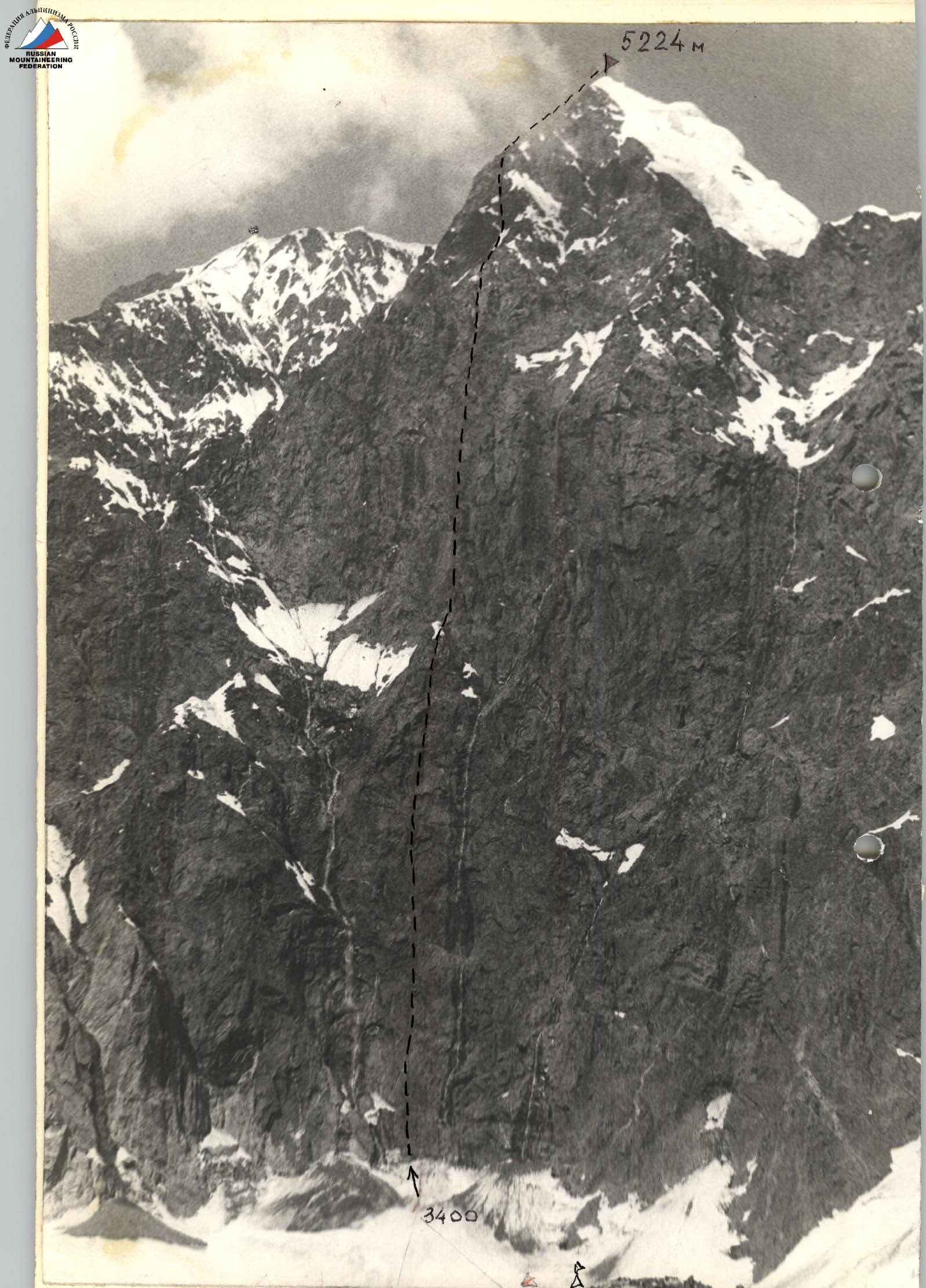
- Peak — Peak 5224 m (proposed to be named "Peak Pierre de Coubertin"). Route: first ascent via the center of the Southeast face
- Proposed difficulty category: 6B
- Route characteristics: height difference — 1734 m (3490 m – 5224 m), length of sections with 5–6 difficulty category — 1520 m, of which 6 category — 1010 m, average steepness — 79°
- Number of pitons driven and chocks used for belays (numerator) and creation of artificial anchors (denominator): rock — 261/37, ice stripping — 13, chocks — 131/64
- Total walking hours — 71 h
- Number and characteristics of bivouacs: 7 bivouacs, including: 1 hanging, 3 sitting, 3 lying.
- Team of the USSR Armed Forces: Fedotov Yury Nikolayevich MS — leader, Golubev Nikolay Nikolayevich MS — deputy leader, Dzhibráyev Yury Georgiyevich MS, Egorov Viktor Mikhailovich CMS, Zhak Viktor Vladimirovich CMS
- Team coach: Dzhibráyev Yury Georgiyevich
- Departure and return dates:
departure — July 26, 1980, return — August 2, 1980
Brief Overview and Approach to the Route
Peak 5224 m is the highest point in the eastern part of the Zeravshan Range. The massif is located 6 km west of the junction point (70°35′ E, 39°15′ N — Peak Iglá) of three ranges: Alay, Zeravshan, and Turkestan. Here, the Zeravshan Range is a narrow mountain chain with peaks reaching 5000 m and more: Belaya 4955 m, Peak 4970 m, Peak 5224 m, Golova 5021 m. The northern slope of the range has significant glaciation. The Belý, Akhun, and Nazar-Aylyak glaciers are left tributaries of the Zeravshan glacier. The southern slopes drop off with powerful rock walls into the vast Darapióz glacier (3200 m) cirque, feeding the Yarhich river system. The Darapióz glacier has three sources: West, Central, and East. The Southeast face of Peak 5224 m dominates the western branch of the Darapióz glacier. The mountains are composed of schist, gray granites, basalts, and magmatites. Since the area belongs to the Alpine orogeny, its seismic activity is significant.
From an alpinistic perspective, the peaks surrounding the cirque and adjacent gorges are interesting. No ascents have been recorded here, according to our data.
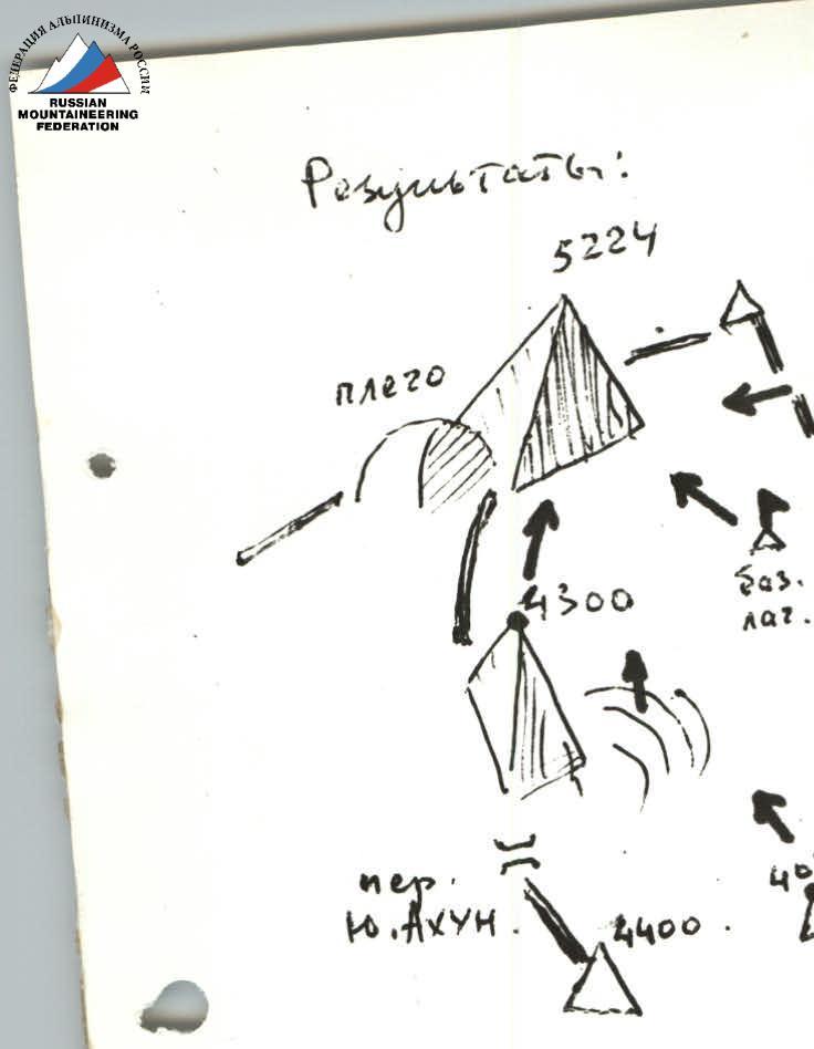
Approach to the route: from Dushanbe (along the Dushanbe — Jirgatál road) to the village of Khait — 260 km (by car), then from Khait along the mountain road in the Yarhich gorge to the Darapióz river — 30 km (by car). Up the Darapióz (Pióz-Dará) gorge 22–25 km to the base camp at the glacier tongue — by caravan (8 hours). The trail follows the right (orographically) bank of the gorge and crosses to the left bank over a snow bridge 6–7 km below the glacier tongue. The base camp was located on the left (orographically) bank of the Darapióz river at an altitude of 2700 m (spring, flat areas, just below — a grove of low trees). From the base camp along the moraine-covered glacier on the right (in the direction of travel) side to the confluence of the three glacier branches (altitude 3200 m) — 3 hours 30 minutes walking. Then across the open glacier to the west (in the direction of travel — to the left) to the median moraine of the cirque (40 minutes) to the storm camp (altitude 3250 m), which is 40–45 minutes walking from the bergschrund (altitude 3490 m) of the Southeast face of Peak 5224 m.
Photopanorama of the West Darapióz glacier cirque. View from Southeast to Northwest.
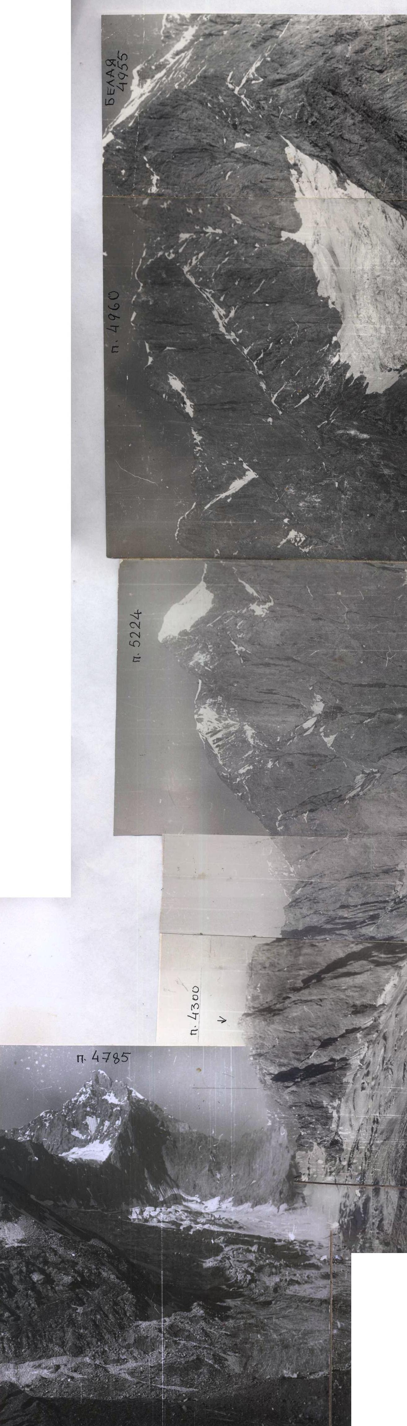
Table of Main Route Characteristics
After each day, record the time:
- departure
- stop for bivouac
- total walking time in hours for the day (excluding rest, food, weather waiting, etc.)
Legend for the table:
Couloir / chimney, edge I, II, R3, R4 30°, R5 ledge for 1st, on 2, III, IV, Monolith (destroyed, icy), V, VI rockfall, etc.
Insurance — Arabic numerals: 2 / creation of artificial anchor — Roman numerals: I II III / pitons: outcrops / and — simultaneously, outcrop and number of pitons.
| № | Date | Section | Length, m | Steepness, ° | Terrain character | Cat. diff. | Condition | Weather conditions | Rock pitons | Ice pitons | Bolt pitons | Chocks |
|---|---|---|---|---|---|---|---|---|---|---|---|---|
| 1 | 2 | 3 | 4 | 5 | 6 | 7 | 8 | 9 | 10 | 11 | 12 | 13 |
| 26.07 | R0–R1 | 90 | 80 | rock wall | 6 | monolith, rockfall | clear | 15/2 | ||||
| R1–R2 | 60 | 40 | ram's foreheads | 5 | crevassed | 4 | ||||||
| R2–R3 | 90 | 30 | wall under ledge | 5 | blocky structure | 7 | ||||||
| R3–R4 | 100 | 10 | overhanging corner | 6 | "plugged" | 5/3 | 2/2 | |||||
| R4–R5 | 80 | 20 | chip | 6 | smoothed | 4 | 4 | |||||
| R5–R6 | 80 | 40 | inner corner | 5 | 2 | |||||||
| R6–R7 | 30 | 0.5–1 | inclined ledge | 5 | partially under overhang | 1 | ||||||
| Departure — 5:00, stop for bivouac — 21:30, walking time — 10 h, bivouac separate, hanging | ||||||||||||
| 27.07 | R7–R8 | 80 | 40 | wall | 6 | blocky structure | clear, strong wind | 3 | 6/4 | |||
| R8–R9 | 90 | 40 | inner corner | 5 | smoothed | 3 | 10/10 | |||||
| R9–R10 | 100 | 40 | inner corner | 6 | chips, "plugs" | 4/2 | ||||||
| R10–R11 | 38 | 75 | wavy slab | 6 | smoothed | 3/2 | ||||||
| R11–R12 | 60 | 90 | crevice | 6 | with "plugs" | 8 | ||||||
| R12–R13 | 100 | 20 | ledge with slit | 6 | monolith | 2/2 | 12/10 | |||||
| R13–R14 | 90 | 20 | inner corner | 6 | smoothed | 5 | ||||||
| R14–R15 | 75 | 40 | stepped wall | 6 | "live" stones | 6 | ||||||
| Departure — 6:30, stop for bivouac — 19:30, walking time — 13 h, bivouac sitting | ||||||||||||
| 28.07 | R15–R16 | 90 | 80 | wall | 6 | large-blocky, overhangs | clear | 12 | 4 | |||
| R16–R17 | 60 | 80 | outer corner | 5 | snow-covered rocks | 8 | 3 | |||||
| R17–R18 | 70 | 40 | slab | 6 | crevassed | 2/1 | ||||||
| R18–R19 | 90 | 30 | inner corner | 6 | with "plugs" | 3 | 3/2 | |||||
| R19–R20 | 100 | 10 | ledge | 6 | with inclined slit | 1/1 | 10/10 | |||||
| R20–R21 | 80 | 40 | inner corner | 6 | smoothed | 10/2 | 5/2 | |||||
| R21–R22 | 90 | 40 | wall | 6 | large-blocky | 5 | 3 | |||||
| Departure — 7:00, stop for bivouac — 11:00 (section R17) | ||||||||||||
| Rock processing (sections R17–R23) from 12:00 to 20:00. Working time — 12 h, bivouac lying. | ||||||||||||
| 29.07 | R23–R24 | 80 | 30 | inner corner | 6 | wet rocks | clear | 3 | 5 | |||
| R24–R25 | 90 | 40 | wall | 6 | large-blocky, overhangs | 6 | 8/6 | |||||
| R25–R26 | 100 | 10 | ledge with slit | 6 | monolith | 3/2 | 1 | |||||
| R26–R27 | 80 | 40 | inner corner | 6 | monolith | 5/5 | 6 | |||||
| R27–R28 | 110 | 5 | oblique ledge | 6 | crevassed | 5 | 2 | |||||
| R28–R29 | 90 | 20 | wall | 6 | large-blocky | 3/3 | 12/10 | |||||
| R29–R30 | 95 | 20 | overhanging wall | 6 | with oblique slit | 6 | 3/3 | |||||
| R30–R31 | 80 | 20 | inner corner | 6 | with "plugs" | 3 | 1/1 | |||||
| R31–R32 | 100 | 5 | ledge | 6 | with crevice | 3/3 | 2 | |||||
| R32–R33 | 90 | 15 | wall | 6 | large-blocky | 1/1 | 4/3 | |||||
| R33–R34 | 100 | 5 | ledge | 6 | with inclined slit | 2 | ||||||
| R34–R35 | 80 | 20 | wall | 5 | dissected | 4/4 | 5 | |||||
| Departure — 6:30, stop for bivouac — 21:30, walking time — 14 h, bivouac sitting | ||||||||||||
| 30.07 | R35–R36 | 90 | 40 | chimney with plug | 6 | "live" stones | cloudy, strong wind | 3/1 | 3 | |||
| R36–R37 | 80 | 60 | inner corner | 5 | partially icy | 9 | 4/3 | |||||
| R37–R38 | 95 | 10 | overhanging chimney | 6 | monolith | 2/1 | ||||||
| R38–R39 | 80 | 80 | inner corner | 6 | ice "plugs" | 15 | 2 | 8 | ||||
| R39–R40 | 90 | 80 | chimney | 6 | snow-covered | snow | 13 | |||||
| Departure — 7:00, stop for bivouac — 18:00, walking time — 10 h, bivouac sitting | ||||||||||||
| 31.07 | R40–R41 | 70 | 40 | outer corner | 5 | icy rocks | cloudy, moderate wind | 8 | ||||
| R41–R42 | 60 | 40 | ice ridge | 5 | dense ice | 5 | 5 | 4/4 | ||||
| R42–R43 | 0 | 10 | ledge | 6 | with oblique slit | 5/2 | ||||||
| R43–R44 | 90 | 20 | wall | 6 | large-blocky | 3 | 2 | |||||
| R44–R45 | 70 | 40 | outer corner | 5 | icy rocks | 7 | ||||||
| R45–R46 | 60 | 10 | ice groove | 5 | natty ice | snow | 2 | |||||
| R46–R47 | 80 | 40 | wall | 6 | icy rocks | snow | 15/3 | |||||
| Departure — 7:00, stop for bivouac — 15:00, walking time — 8 h, bivouac lying | ||||||||||||
| 01.08 | R47–R48 | 50 | 160 | rock edge | 4 | icy rocks | fog, snow showers | 18 | ||||
| R48–R49 | 40 | 40 | snow-ice "cushion" | 4 | scaly ice | 3 | ||||||
| Departure — 8:00, stop for bivouac — 12:00, walking time — 4 h, bivouac lying | ||||||||||||
| 7 days | Total | 1801 | 6 cat. diff. | 1010 m | 216 | 13 | 67 | 131/64 | ||||
| 5 cat. diff. | 510 m | |||||||||||
| 4 cat. diff. | 281 m |
PROFILE of the Southeast face of Peak 5224. The photo was taken from the east, from the Central Darapióz glacier.
Explanation of the Table of Main Characteristics and Brief Description of the Route Passage
From the storm camp on the moraine of the West Darapióz glacier, it takes 45 minutes to walk to the base of the Southeast face of Peak 5224 m. The face is located in a concave "amphitheater." In the center, there are 2 powerful waterfalls. The section of the face between the waterfalls, ending 670 m higher in a pointed bastion, resembles the shape of a giant "pencil" (section R0–R17). The glacier between the face and the median moraine is gentle and not moraine-covered. At the face, there is a short ascent (2 ropes) leading to the bergschrund (5 × 7 m). The altimeter shows 3490 m. Beyond the bergschrund is the start of the route.
Sections R0–R7; 1st day — July 26
The first team of 3 departs at 5:00. The route begins on a sheer monolithic wall with cracks for reliable belays and for climbing in galoshes without a backpack on small holds. Climbing is difficult (section R0–R1, photo 1). After 80 m, the wall transitions into a ram's forehead, which is exposed to rockfall from the right waterfall (section R1–R2). Then, there's an exit under overhangs (section R2–R4), where the leading trio "hides" from rockfall danger from 10:00 to 16:00. Altitude 3640 m. 1st control point. The first team rests in a hanging position under a reliable ledge; this spot will be used by the second team for an overnight bivouac, descending on fixed ropes with belays. At 16:30, the leading team passes the ledge using ladders (very difficult) along an inner corner with plugs; they reach the level of an inclined ledge. Planned bivouac site. Here, they move under the left overhang as the ledge strip is fragile. The bivouac is hanging, altitude 3700 m — 21:00 (section R7, photo 2). There is no water on these sections; they carry it with them.
Sections R7–R15; 2nd day — July 27
At 6:30, the second team catches up with the first, and the team continues together: up the wall, slightly left into an overhanging inner corner (section R8–R10). The corner leads to a smooth, wavy slab (section R10–R11). Climbing with utmost caution; the slab must be traversed quickly as it's potentially rockfall-prone with the onset of activity from the right waterfall. They move up under overhanging sections (section R11–R14). A 20-meter crevice (section R11–R12, photo 3), climbing in a stem position (it throws them off), leads under a massive ledge with a slit (section R12–R13). Initially, it seems like piton placement is necessary, but chocks and wide channels fit into the slit. 12 times, they re-hang "fifi" ladders, and the ledge is behind them. After the next inner corner (section R13–R14), they exit onto a stepped wall. Massive blocks lie unsteadily; the wall leads after 40 m to a smooth, sheer chip — the base of the "pencil's tip" (section R15). They settle in for a sitting bivouac on narrow ledges for a long time. There is no water. The day was very tense. They worked for 13 hours. Altitude 3980 m.
Sections R15–R23; 3rd day — July 28
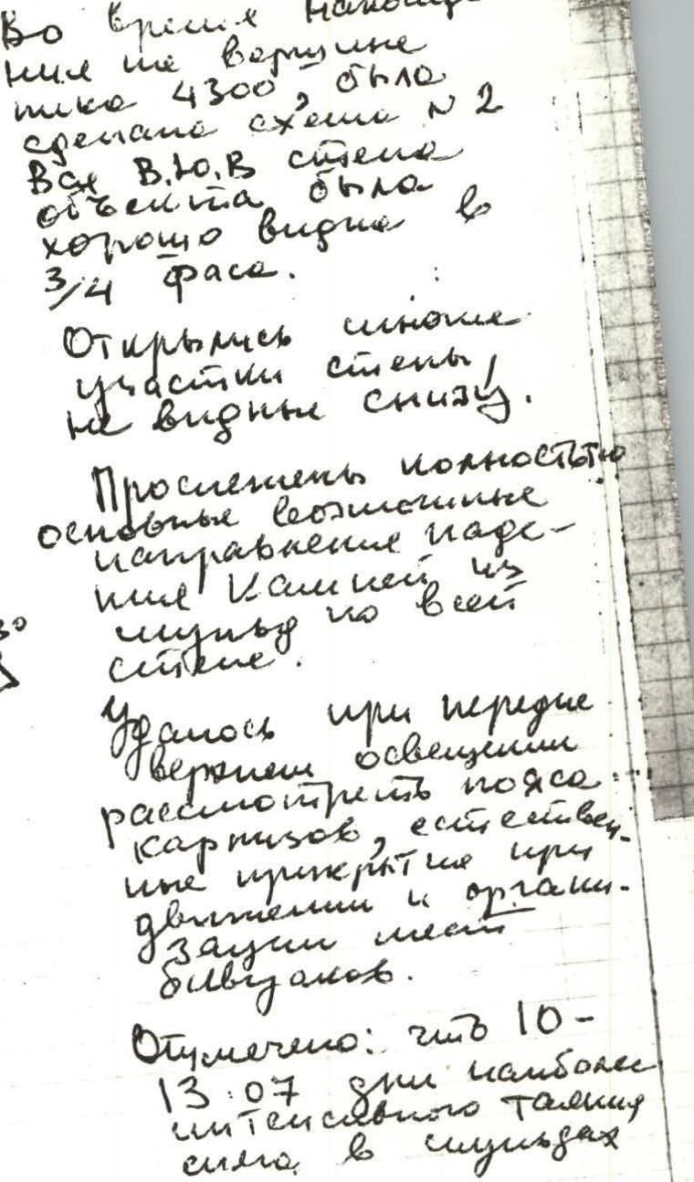
They start moving at 7:00. The wall. Rocks are sheer and strong (section R15–R16), good cracks for pitons. They exit onto the "edge" of the pencil. A 60-degree, weathered ridge with small walls leads to the snow-ice tip of the pencil (section R17). Altitude 4160 m. The trio remains to prepare bivouac sites. The duo, after breakfast (with water!!!), heads up to process the gray wall, and after 3 hours, they are relieved by the second team. At 18:00, snow grains start falling, but a comfortable lying bivouac is already ready. At 20:40, the duo returns from processing. Approximately 200 m of fixed ropes (section R17–R23) are in place down to a smoothed gray slab. Especially difficult is a 30-meter inner corner, filled with rock plugs and ending in a large ledge (section R18–R20, photo 4). Here, as well as further, chocks are used for belays and artificial anchors. The "advance" for tomorrow is good. Bivouac is lying. Rest is full. This is the second control point.
Sections R23–R35; 4th day — July 29
They depart at 6:30. Following fixed ropes, they reach the end of the processed section. Above, the wall looks very impressive — tiers of overhanging ledges (section R24–R35; photos 5, 6, 7). They choose a proven variant of movement along inner corners, as it allows the use of chimney technique, chocks, and more effective belay organization. Outer corners are generally smooth, with fewer extensive cracks. This day is a cascade of ledges and a complete lack of water. Every meter is very difficult; ladders on chocks and "sky hooks" are the primary means of movement for the first (photo 6). The rest follow on two jumar clamps in étriers (photos 5–7). Often, backpacks are pulled separately; teams often alternate. There is no water. Only towards the end of the day, in a chip under a ledge (section R35), they find residual snow. At 21:30, they settle into a sitting bivouac. Above them is an overhang — the roof of a ledge. They melt snow for water. Altitude 4610 m. Very difficult day. Third control point.
Sections R35–R40; 5th day — July 30
Departure at 7:00. Cold, strong wind. From the bivouac, the only path is a chimney with a plug (section R35–R36). Extremely difficult bypass of the plug and further expansion of the chimney into a long inner corner. Rocks are smooth, icy, cracks filled with ice (section R37), and the corner ends in an overhanging chimney (section R37, R38, photo 9). The left wall along the corner and chimney is basaltic with a cascade of ledges and mini-ledges. The first climber faces extreme difficulty; those behind are not much easier as backpacks get stuck in the narrow chimney. Further, the path lies in a "snake-like" fracture of rocks and ledges, where the inner corner is filled with ice plugs, some of which hang precariously. The weather worsens; they need to exit this "pipe." Two more ropes (section R39–R40) — and the chimney breaks into a balcony. On it, at an altitude of 4930 m, at 17:00, they sit down for a bivouac (section R40). It's snowing.
Sections R40–R47; 6th day — July 31
Departure at 7:00. Visibility is poor; rocks are "gray" from frost; 40 m up a weathered rock ridge (section R40–R41). Here, rocks have many icy sections. Ahead is an ice ridge. Dense ice (section R41–R42). They screw in 5 ice screws for belays, then proceed on crampons. The ridge abuts a wall with a ledge at the base (section R42–R43, photo 10). The oblique slit accommodates channels and chocks. It's thrown off significantly. Above the slit, several protruding blocks of the next wall; movement is slightly left, exiting onto a 40-meter outer corner, blocks are icy (section R44–R45). The ridge above is cut by a groove (section R45), the narrow bottom of which is filled with ice; at the junction with the next wall, they screw in two ice screws. It's snowing, cold. The plan for the day is to reach the ridge. The altimeter shows above 5000 m. Again, an ascent of dissected, icy rocks (section R46–R47). Everything is in fog; they are already on the rocky pre-summit ridge. Here, they lay out a wide platform. Water from a snowpatch. Bivouac is lying. Altitude 5100 m.
Sections R47–R49; 7th day — August 1
Further path to the summit is along a 50-degree rocky ridge, small walls, dissected rocks (section R47–R48). Here, there's wind and fog charges. After 4 ropes — a snow-ice cushion of the summit. Scaly ice. They move on crampons for 40 m (section R48–R49), belays via ice screws. At 12:00, they are on the summit (a rocky elevation on the western side). To the northwest and north lies an ice slope. Beyond the Zeravshan glacier — a "fence" of Turkestan Range peaks (cloudy there). To the east from Peak Iglá — the Alay chain; visibility is better here; in breaks, Peak Kommunizma is visible. Clouds are approaching from the southwest. They build a cairn. Leave a note. They name the peak "Peak Pierre de Coubertin." At 12:40, it starts snowing. Visibility is already poor to the north; they prepare platforms and set up tents. They discuss the descent variant again and transmit their decision via radio to the storm camp — descent via the northwest slope to the Zeravshan glacier.
August 2
They begin the descent early in the morning (30 ropes) to the Akhun glacier — a right tributary of the Zeravshan glacier (crampons, ice screws, ice axes), then bypass the northern ridge of Peak Pierre de Coubertin — exit onto the Zeravshan glacier, ascent along it to the West Darapióz pass, and through the pass (2B category difficulty) — descent to the storm and base camps (arrived at 18:00).
R0
R0–R14
200 m 1Б мОАС ± 500 m
Observations on the Lower Belt of the Wall
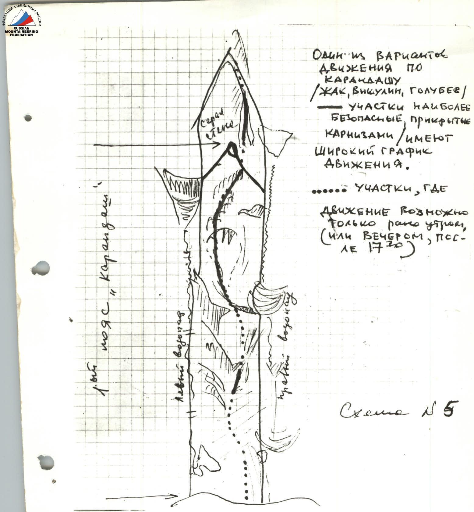
Scheme № 5