

First Ascent of Hazor-Mech Peak via the Northeast Face, Category 3A Difficulty
MOSCOW — 1963
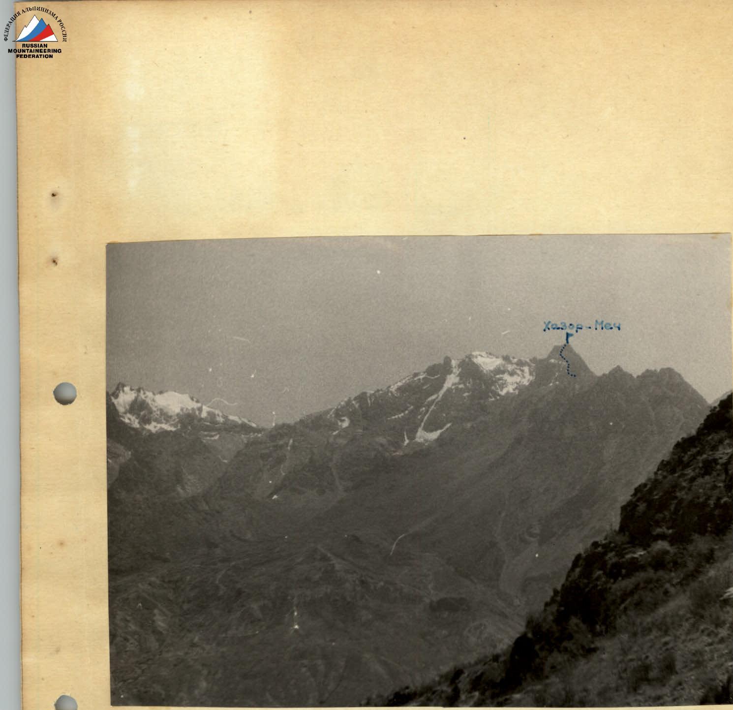 Hazor-Mech peak (View from the Shadon River valley)
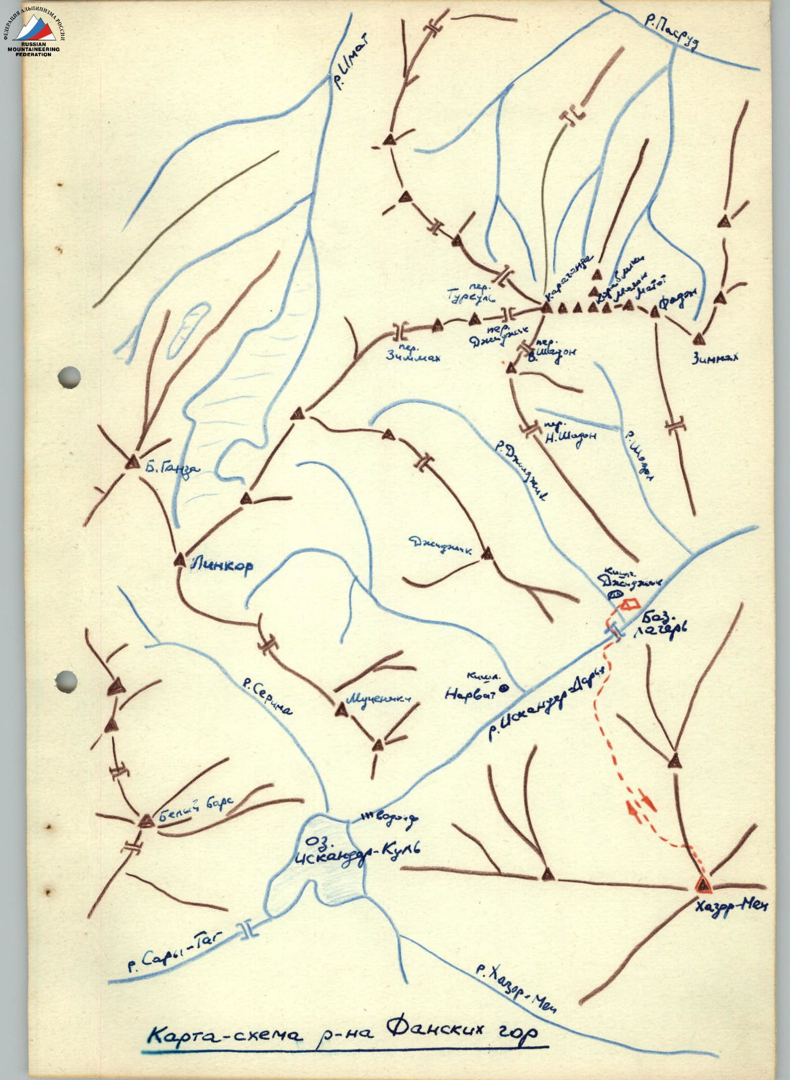 Map of the Fann Mountains area
Description of the Climbing Area
In the western part of the Zeravshan Range, between the Dan-Darya and Kshut-Darya river basins, lies a relatively isolated massif known as the Fann Mountains. The peaks of this mountain node reach heights of 5500 m (Chimtarga — 5487 m, Big Ganiza — 5415 m, Dukdon — 5208 m, Zengia — 5105 m, etc.) — a total of up to 10 peaks exceeding 5000 m.
The Fann Mountains are situated between the Zeravshan and Gissar Ranges. Significant glaciation in this area is primarily found on the northern slopes. South of Big Ganiza peak, in the upper reaches of the Iskander-Darya River, at an altitude of 2238 m, lies the large and very beautiful Lake Iskander-Kul, which is a dammed lake. This area remains understudied, and many peaks await their first ascents.
The Hazor-Mech peak is located at the intersection of the western ridge, which runs from Lake Iskander-Kul to the east, and the northern ridge, which runs from the Unnamed peak, 3 hours' walk south of the Dzhidzhik village, situated 8 km from Lake Iskander-Kul along the Iskander-Darya River.
From the "Varzob" alpine camp to the Dzhidzhik village, it takes 8 hours by car via the Dushanbe — Leninabad highway (through the Anzob Pass).
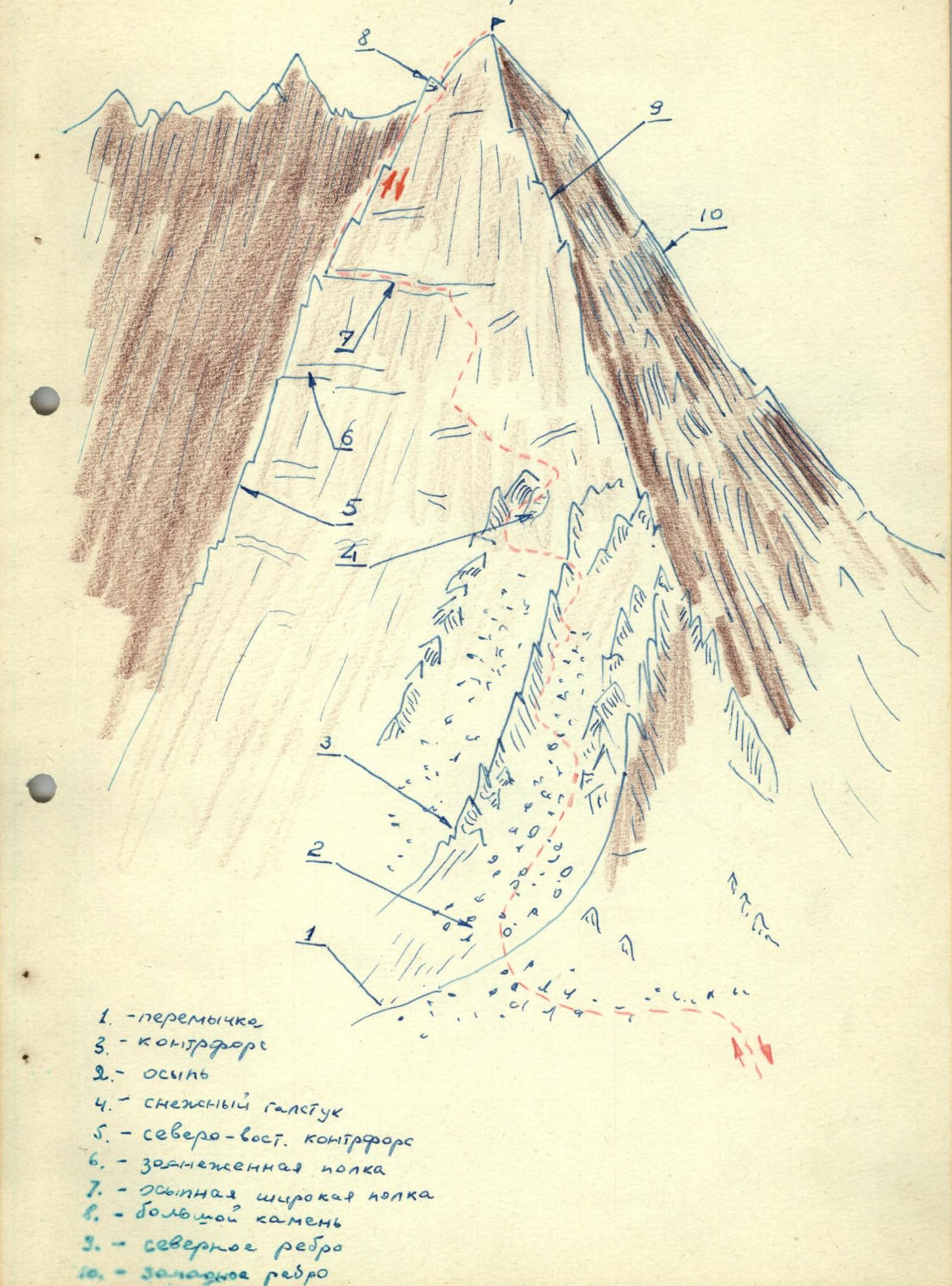
Hazor-Mech
Legend:
- Saddle
- Scree
- Counterfort
- Snow tie-in
- Northeast counterfort
- Snow-covered ledge
- Wide ledge
- Large boulder
- North ridge
- West ridge
Description of the Ascent
On August 8, 1963, a group of climbers from the "Varzob" alpine camp, consisting of:
team leader Andreev V. — 1st sports category team members Bezljudnyj P. — 3rd sports category Veretennikov V. — 3rd sports category Nechesova N. — 3rd sports category Tataurova M. — 3rd sports category
reached the summit of Hazor-Mech at 18:30, completing the first ascent via the northeast face, category 3A difficulty.
From the base camp located near the Dzhidzhik village:
- cross the Iskander-Darya River via a bridge;
- follow the trail upstream until the neighboring village of Narvit is opposite;
- turn left into a side valley;
- a good trail leads past an irrigation canal, gradually turning right;
- leave the trail and proceed through the forest, in the middle of the valley, towards the visible sharp pyramid — this is the Hazor-Mech peak.
Terrain features:
- to the left (in the direction of travel) from Hazor-Mech peak, a jagged ridge extends northward;
- to the right — gentle slopes.
Recommendations:
- at a large boulder, after which the moraine begins immediately, it is possible to leave backpacks, taking only climbing gear and essential items;
- ascend the moraine to the base of Hazor-Mech peak;
- turn left and traverse via fine scree mixed with earth towards a small pass on the northern ridge.
Conditions:
- there is no water in this area;
- from the pass, the lower part of the route is visible;
- from the pass, the main and steep north ridge leads directly to the summit, heavily dissected and damaged in its lower section.
Movement from the pass:
- initially, proceed left along the scree towards a visible couloir.
On the right-hand side (in the direction of travel), ascend the scree to approximately the middle of the couloir, then cross the couloir and exit onto simple rock on a small counterfort. Ascend the rock with alternating belays for 5–6 rope lengths, then traverse the counterfort, cross a second scree-filled couloir, and exit onto the rock of a second counterfort. Ascend the rock for two rope lengths, then again cross the second couloir in its upper section, bypassing steep rock on the second counterfort to the right. Further, ascend via scree-covered ledges in a zigzag pattern, leftward and upward along moderately difficult rock towards the middle of the wall and in the direction of a wide scree-covered ledge, partially snow-covered.
Upon reaching the wide ledge, carefully proceed left along it to a ridge descending from the summit. The route then follows this ridge to the summit. The rock on the ridge is difficult, consisting of slabs with a steepness of 60–70°. Initially, ascend two rope lengths along the slabs and a crack with piton belays under an overhanging wall. Under the wall, move left for 8–10 m to a saddle on the ridge extending eastward from Hazor-Mech peak. The ridge is very sharp, with steep walls to the north and south.
From the saddle, a 5-meter wall (steepness — 70°) leads to simple rock, and after one rope length — to the summit.
The summit of Hazor-Mech is a narrow, short ridge. To the south and southeast, sharp, steep ridges descend from the summit.
From the saddle below the north ridge to the summit — 3 hours 30 minutes. Descent from the summit via the ascent route takes 1 hour 30 minutes to the saddle, and 4 hours to the base camp.
Conclusions
- The ascent of Hazor-Mech peak via the northeast face is a rock climbing route, category 3A difficulty.
- The total elevation gain from the saddle to the summit of Hazor-Mech is approximately 500 m.
- The average steepness of the wall is 60°.
- 8 rock pitons were placed on the wall.
- From the base camp to the summit, the trip took 18 hours of walking time.
- The most technically challenging sections: the 80-meter wall from the snow-covered ledge to the summit.
- The height of Hazor-Mech peak (relative to known surrounding peaks) is approximately 4000 m.
Team leader
 (V. Andreev).
Comments
Sign in to leave a comment