ASCENT DOCUMENT 60a
- Climbing type — rock.
- Climbing area, ridge — Pamir-Alay, Fann Mountains.
- Peak, its height, ascent route — Sakharnaya Golova, 4971 m, via the "table" (center of the north face).
- Proposed difficulty category — 5B.
- Route characteristics: a) height difference — 1000 m, b) length of 5B category sections — 675 m ("pillar"). c) average steepness: "pillar" — 75°, route — 65°.
- Pitons hammered: a) rock — 148, b) ice — 28, c) bolted — none.
- Number of climbing hours — 31 h.
- Number of bivouacs and their characteristics — 2 (1 — lying, 2 — semi-reclining).
- Surname, name, patronymic of the leader, participants:
- Grushevsky V. G. — leader, Candidate Master of Sports.
- Shadskaya L. I. — participant, Candidate Master of Sports.
- Shlemchenko S. — 1st sports category.
- Linkor P. — 1st sports category.
- Team coach — Sogrin Sergey Nikolaevich, senior instructor, Master of Sports.
- Dates of departure and return:
- August 15, 1978 — preparation
- August 16, 1978 — departure on route, overnight stay
- August 17, 1978 — ascent to the summit, overnight stay
- August 18, 1978 — descent from the summit to the base camp.
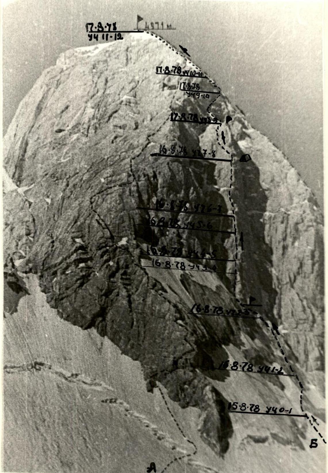
A-ASCENT ROUTE via the North-Eastern ridge of Sakharnaya Golova peak, 5B category. B-ASCENT ROUTE via the North face ("PILLAR") — 5B category. C-BIVOUAC LOCATIONS D-CONTROL CAIRNS
EXPLANATORY NOTE TO THE TABLE
On July 14, 1978, the group left the base camp at "Tepa" meadow at 16:00 and stopped for the night under the Vilnius peak massif.
On July 15, at 9:00, they headed to the Akhsbasoy glacier. At 14:00, they stopped at the glacier moraine and started processing the route. That day, it was decided to process part of the route, i.e.:
- cross the bergschrund;
- if possible, hang a rope on the rocks.
They only managed to process the bergschrund, as they had to cut steps while crossing it, and the participants got wet. The rocks did not present a particular difficulty, so they did not hang a rope on them. The bergschrund was processed right under the "pillar".
July 16. At 8:00, they left the Akhsbasoy glacier moraine and approached the bergschrund via a snowy slope, where they had hung fixed ropes (R0–R1). The first rope team, Grushevsky V. — Shlemchenko S., followed the fixed ropes to the rocks, where a rope was left. While the first team was crossing the rocky section (R1–R2), the second team, Shadskaya L. — Linkor P., was crossing the bergschrund. After that:
- ascent via rocks with a steepness of 60° towards the right gully, limiting the "pillar";
- after 2.5 rope lengths, they reached a ledge under the "pillar" (R2–R3);
- along the ledge to the left towards a chimney.
At the end of the ledge, there is a control cairn, from which they took a note from the first ascenders led by Ginzburg V. I., left their own, and continued on their way via the chimney. The chimney is followed by a crack. In one place, the chimney overhangs. Climbing is difficult, but it can be done without artificial aids. After the crack, there is a ledge.
The team works:
- without pulling up backpacks;
- the first climber goes without a backpack;
- wearing galoshes.
The weather is good and warm.
From the ledge, 35 m up a steep 90° wall to the next small ledge (R3–R4).
From the ledge, left and up — a 20 m slab. Steepness is around 60°. From the slab, there is an exit to a crack. Along the crack for 20 m, then an exit to the edge of the "pillar", along which 30 m left and up, and further, via a 10 m sheer wall, an exit to a ledge (R4–R5).
From the ledge, a 10 m traverse along the wall to a poorly defined ridge. Along it for 30 m under the red rocks (R5–R6). Under these rocks, on a ledge, they found a note from the first ascenders in a hanging control cairn.
The overhanging red rocks are passed via a crack. After 20 m, there is an exit to the edge of the "pillar" (R6–R7). Another 40 m leads to an inclined ledge, where they set up a bivouac.
While Shadskaya L.'s team was preparing for the night, the first team processed the further route:
- a 40 m traverse left via broken rocks to the start of a chimney;
- ascent via the chimney for 40 m with difficult climbing.
In total, they covered 140 m. They descended to their bivouac via the fixed ropes. They cooked an excellent soup and went to sleep in a 1–1–2 arrangement.
July 17. At 9:00, from their bivouac, they climbed up via the fixed ropes to the upper reception point. Continuation of the chimney:
- along it for 40 m;
- throughout the 60 m, chimney climbing is difficult, using friction, and requires stemmed positions.
Further, the chimney narrows and turns into an overhanging crack. Via the crack and wall — an exit to a ledge. From the ledge, right and up — ascent to the top of the "pillar", where they found a note from a team that had made the second ascent and left their own (R7–R8).
From the top of the "pillar", right and up, a ridge leads with easy climbing. The ridge is 50 m long. Along the ridge:
- via a slab covered with ice;
- climbing is very difficult;
- they had to cut steps as much as possible in the ice;
- via the slab, ascent right beyond the bend for 60 m (R8–R9).
Via the ice, left around the corner into an ice couloir. Along it for 40 m to an exit onto a rocky ridge, to the left of which there is a 40 m wall leading under the ice dome of the summit. The wall is passed via a crack with an overhanging rock (R9–R10). From the ledge, an exit onto the ice dome (R10–R11). The weather starts to deteriorate. A strong, piercing wind blows.
240 m along the ice dome will lead them to the summit. The timing is just right for a communication session. The ice is very poor:
- on top, there is coarse-grained firn;
- turning into ice. Crampons do not hold well.
On the summit, they stop for the night. They found a note from a group of climbers from the "Varzob" alpine camp, consisting of Aizenberg V. and Skachkov A.
July 18. At 9:00, they started descending west towards the saddle between Sakharnaya Golova and the Amna-Krun peak. Descent from the saddle to the south, and, bypassing the Amna-Krun massif to the left, ascent to the Man pass. At 18:30, they returned to the base camp at "Tepa" meadow.
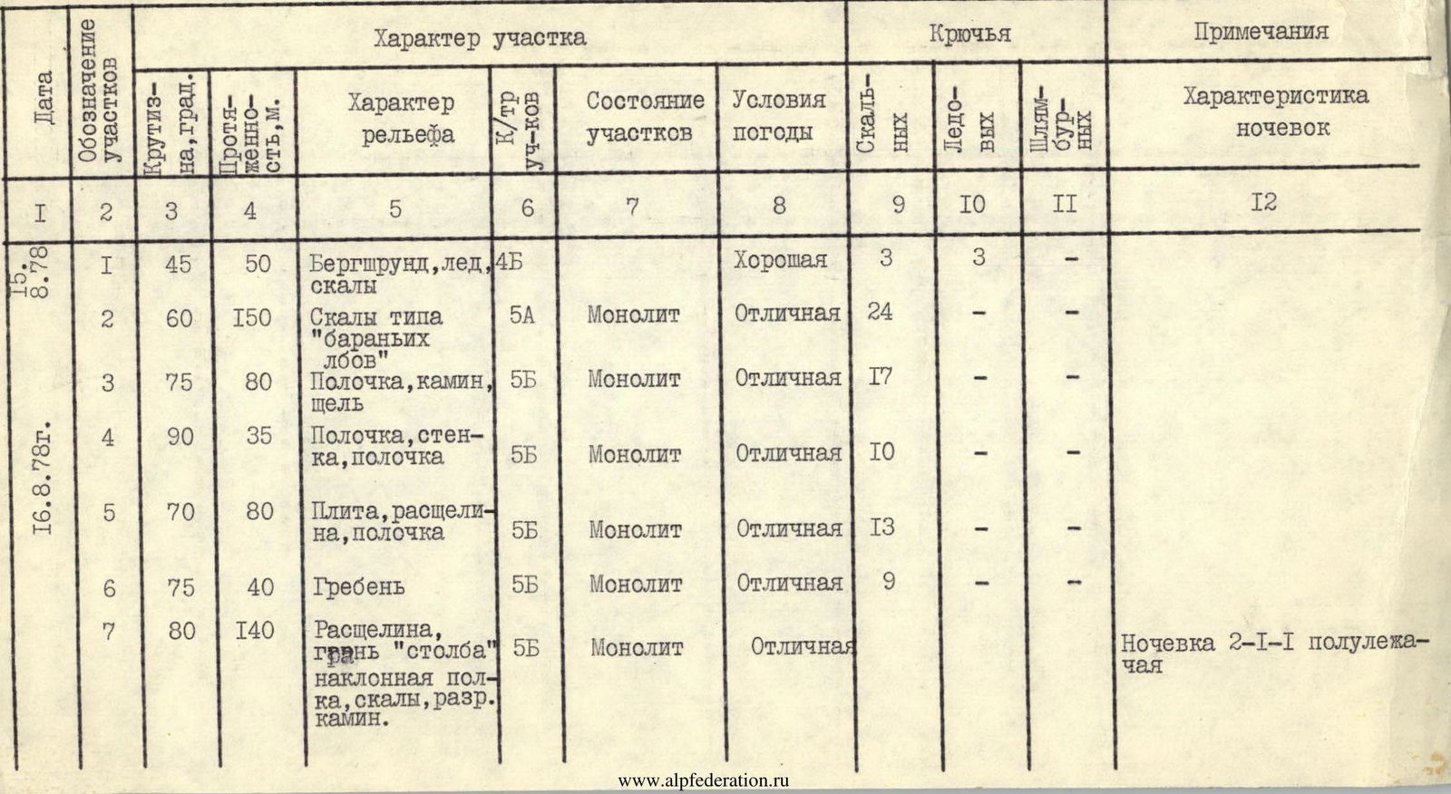
TABLE OF MAIN ROUTE CHARACTERISTICS
| Date | Designation of sections | Steepness, ° | Length, m | Terrain characteristics | Difficulty category of sections | Condition of sections | Weather conditions | Rock pitons | Ice pitons | Bolted pitons | Characteristics of bivouacs |
|---|---|---|---|---|---|---|---|---|---|---|---|
| August 15, 1978 | R1 | 45 | 50 | Bergschrund, ice, rocks | 4 | Good | 3 | 3 | – | ||
| R2 | 60 | 150 | Rocks similar to "ram's foreheads" | 5 | Monolith | Excellent | 24 | – | – | ||
| August 16, 1978 | R3 | 75 | 80 | Ledge, chimney, crack | 5 | Monolith | Excellent | 17 | – | – | |
| R4 | 90 | 35 | Ledge, wall, ledge | 5 | Monolith | Excellent | 10 | – | – | ||
| R5 | 70 | 80 | Slab, crack, ledge | 5 | Monolith | Excellent | 13 | – | – | ||
| R6 | 75 | 40 | Ridge | 5 | Monolith | Excellent | 9 | – | – | ||
| R7 | 80 | 140 | Crack, edge of "pillar", inclined ledge, rocks, broken chimney | 5 | Monolith | Excellent | Bivouac 2–1–1, semi-reclining | ||||
| August 17, 1978 | R8 | 90 | 110 | Chimney, crack, top of "pillar" | 5 | Monolith | Excellent | 29 | – | – | |
| R9 | 60 | 110 | Ridge, slab | 5 | Monolith | Excellent | 15 | – | |||
| R10 | 60 | 80 | Ice, couloir, rocky wall | 5 | Monolith | Good | 5 | 8 | |||
| August 18, 1978 | R11 | 45 | 240 | Ice dome | 4 | Ice covers coarse-grained firn | Good, cold wind blows | – | 17 | Bivouac lying on the summit |
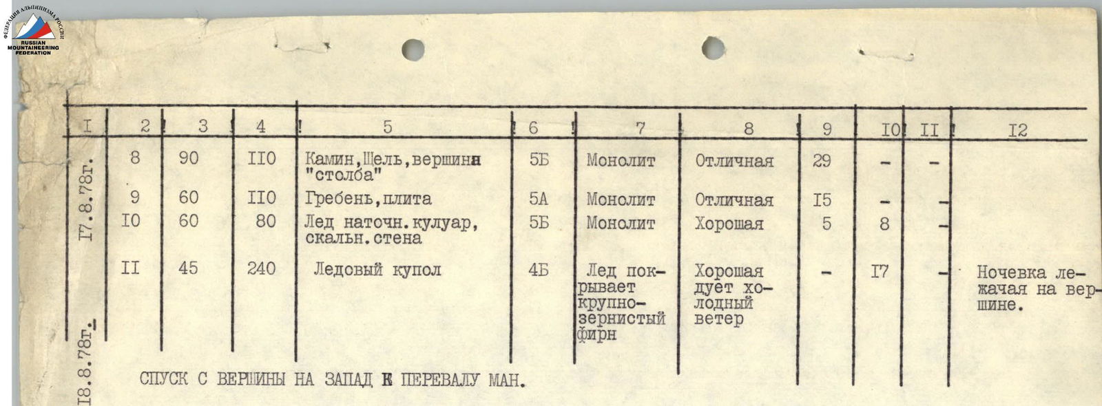
DESCENT FROM THE SUMMIT TO THE WEST TOWARDS THE MAN PASS