Ascent Description of Sugar Loaf Peak via the Central Part of the East Face
Approximately 5–6 category of difficulty.
The route was traversed by a group of participants from the LETI alpinade named after V.I. Ulyanov (Lenin).
FAN MOUNTAINS, Leningrad,
1974
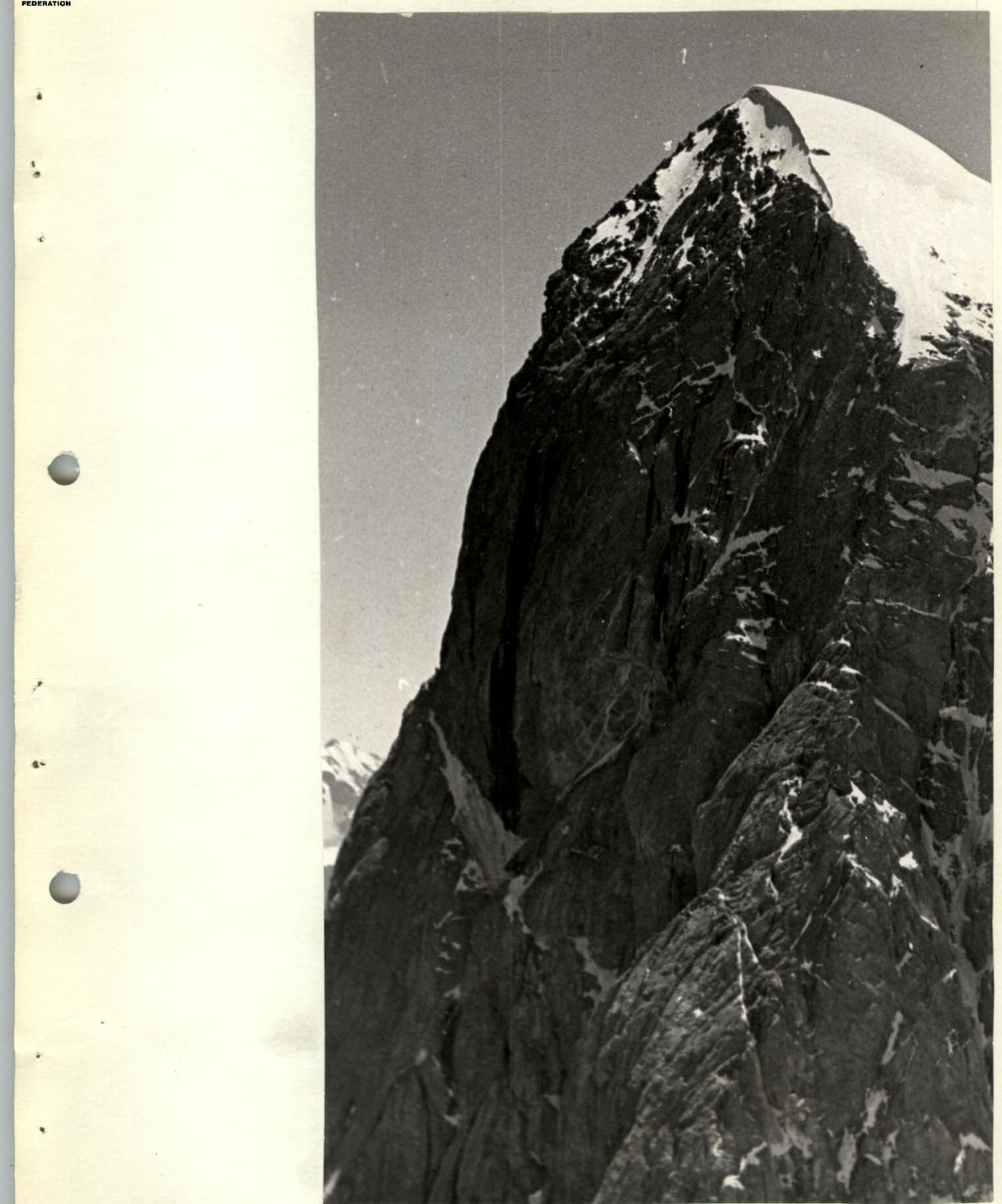
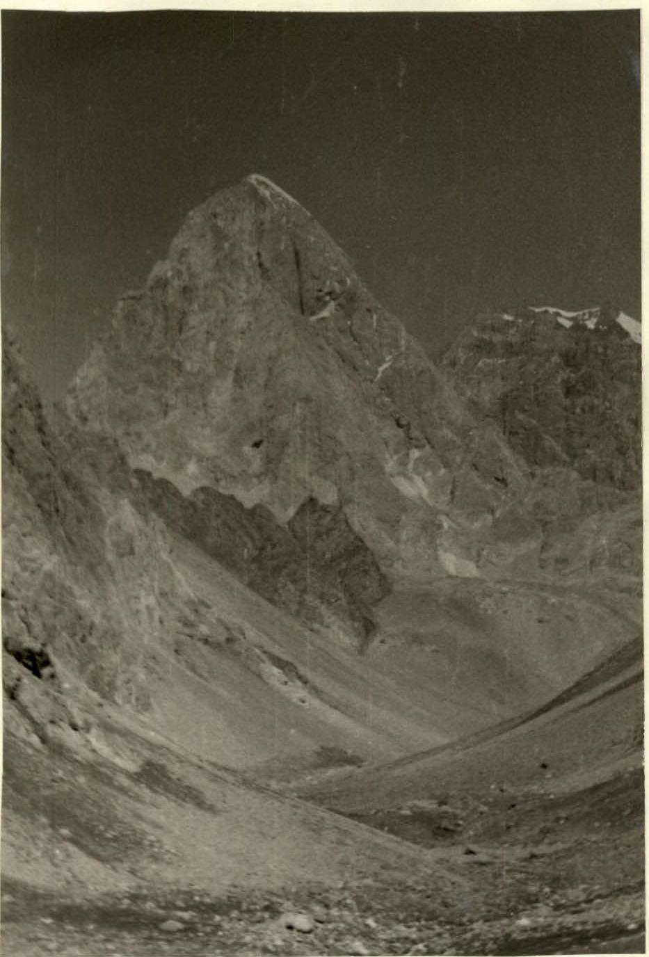 Peak Sugar Loaf (4971 m) from the east.
2. Brief Geographical Description of the Area and Sporting Characteristics of the Ascent Object
Sugar Loaf peak (4971 m above sea level) is located in the Zeravshan ridge (Fan Mountains). The section of the ridge where the peak is situated serves as a watershed for the basins of the following rivers:
- Akhbasoi (to the east)
- Pushnovat (to the west)
To the north of Sugar Loaf peak lies the nodal peak of Moscow (5183 m). To the south of Sugar Loaf peak are two passes — Planovy and Estonsky.
A characteristic feature of Sugar Loaf peak is the absence of relatively simple ascent routes (the lowest difficulty category being 4B).
In the annals of Soviet mountaineering, as published in the collection "Conquered Peaks," the first ascent to the peak was recorded in 1953 (a group consisting of Martynov V., Zmeev B., and Kuznetsov A. — from the "Iskra" alpine camp) via a route of 4B category of difficulty.
Currently, according to the classification of peaks in the USSR, there are three routes of 4B category of difficulty to Sugar Loaf peak:
- from the southwest,
- along the southern ridge,
- from the Akhbasoi glacier along the wall to the saddle of the western ridge.
There is also one route of 5A category of difficulty (along the northeastern edge). Additionally, a traverse route Sugar Loaf — Moscow — Blok, 5–6 category of difficulty, passes through the peak.
The main difficulty of these routes lies in overcoming the rocky sections.
Until 1974, the central buttress of the East face of Sugar Loaf peak remained unclimbed. This route is the most extensive and challenging of all those listed above. The route begins directly from the scree below the wall and leads to the peak via the shortest path. The route spans 1300 m with a height difference of 1150 m.
The route can be divided into three parts:
- the lower part — a bastion adjacent to the buttress and connected to it by a short snow-ice saddle;
- the middle part — the buttress itself;
- the upper part — the summit tower.
Throughout the route, the rocky terrain is heavily smoothed, with many sections having small and brittle holds. During the ascent, rockfalls were not observed in the vicinity of the route. However, a significant number of loose rocks suggest that the rockfall risk on the route increases during the snowmelt period.
The first ascent via the central buttress of the East face of Sugar Loaf peak was made on June 9–14, 1974, by a group of climbers from the Polish High Mountain Club, consisting of:
- Bernard Uhmański — leader
- Ryszard Kowalski
- Janusz Skorek
- Marek Kasicki
- Janusz Ferencski
- Zbigniew Wach
The route was traversed with three bivouacs on the ascent. We were aware of the high assessment given to the route by the Polish climbers.
Upon approaching the route, our group had information about the route's length (49 ropes) and the presence of extremely difficult climbing sections in its lower and upper parts, traversed by the Polish group without the use of artificial support points.
E. face (p. Sugar Loaf) view from the Akhbasoi gorge.
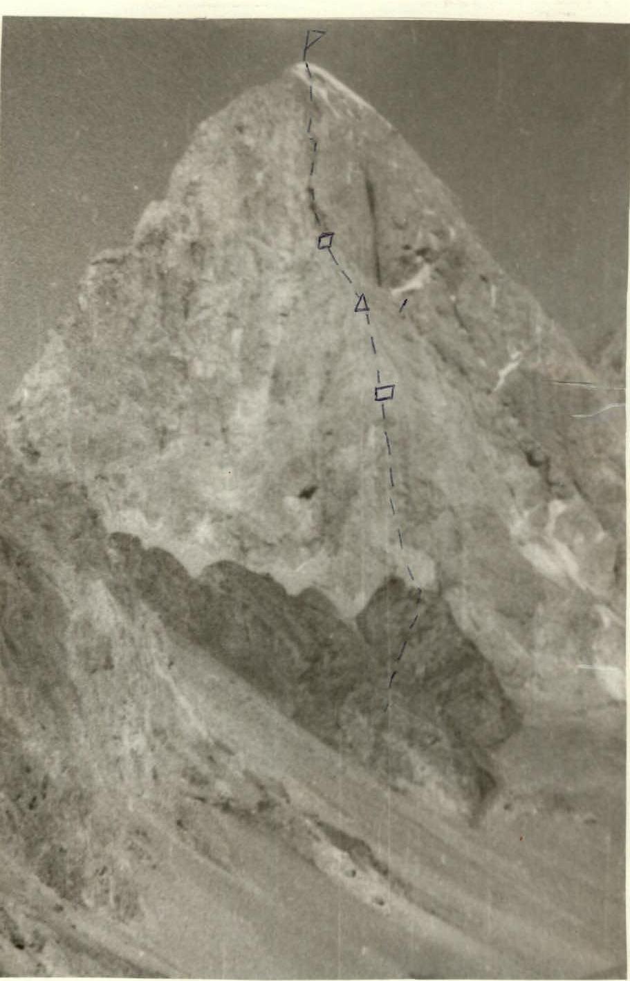
- Δ — bivouac.
- ☐ — control cairn.
Central buttress of the E. face of p. Sugar Loaf.
6. Order of Route Traversal
First day — August 17, 1974.
We leave our base camp at Tepe clearing at 8:00. Two and a half hours of walking on the trail, followed by an hour and a half on the moraines — and we are at the base of the route. We quickly have a snack, establish the order of movement.
We ascend another 30 m up a gentle scree and then move up to the right 40 m (section 0–1). We rope up. Borya Barulin (Barulin-Zayonchkovsky rope team) starts the ascent nervously. Through a system of internal corners, Boris reaches a vertical crevice under an overhanging wall (section 1–2). Then, via the crevice and a vertical wall — very difficult climbing (sections 2–3, 3–4).
Then, across very steep slabs (section 4–5), Barulin approaches the "ram's foreheads." Movement is always simultaneous. Further, across the foreheads of medium difficulty (section 5–6) into an internal corner (section 6–7), after passing which, we emerge onto steep slabs.
80 m across the slabs (section 7–8) leads to a saddle between the 1st bastion and the buttress itself. Traverse 3 m to the left. 120 m through a system of internal corners and crevices (section 8–9), which lead to narrow, smoothed crevices (section 9–10) — everywhere difficult climbing, transitioning into crevices again — climbing becomes somewhat easier (section 10–11).
The crevices lead to a 15-meter wall with difficult climbing (section 11–12). After the wall, up to the left onto a ridge and along it 25 m to a steep ascent (section 12–13). Bypass the ascent to the right through internal corners and small ledges (section 13–14), exit to a grotto.
Further to the right, then vertically up a vertical wall with small, smoothed holds — very difficult climbing (section 14–15). After the wall, up to the right across overhanging "foreheads" (section 15–16) with very complex friction climbing, exit under a sheer wall — 10 m (section 16–17). Then, up to the left across gentle (60%) "foreheads" to a bivouac site (25 m — 2 hooks, section 17–18). We hammer in 7 hooks, hang the tent on them, and settle in for the night.
Second day — August 18, 1974.
We depart at 9:00. Across the foreheads and internal corners, we exit onto a ridge (section 18–19). On the ridge, slabs of medium difficulty, across them (section 19–20) we reach the Polish bivouac site. Control cairn.
Further, directly up through narrow (15–20 cm) crevices with "live" rock plugs (section 20–21). In some places, bypass the plugs across smoothed rocks. Climbing is done in galoshes on friction. Overhanging sections. Extremely difficult climbing. The first person goes with a lightened backpack, the rest follow on belay ropes.
Section 21–22 — internal corners with crevices. Often encounter overhanging sections. The terrain consists of rocks with a fine structure that crumble easily under hand. Hammering in hooks is challenging. Large "boxes" are used. Twice, we encountered Polish aluminum "petals," which, however, are easily removed after being loosened.
Very difficult climbing (without breaks) after the second control cairn (third Polish bivouac site) does not allow traversing a rope (40 m) in less than 1 hour. The complexities of the terrain described above, to some extent, contributed to B. Barulin losing his grip during a very difficult traverse (section 22–23) from an internal corner (which became so wide that it was only possible to traverse it on the left side) to a narrow ledge for one participant in front of us. The belay rope tightened, and the incident was resolved.
A chimney (section 23–24) 30 m long with smoothed walls (overcome using chimney technique) and a plug at the top (very difficult climbing). Then, 15 m of difficult climbing across a smoothed, sheer wall (section 24–25).
A ledge. The first person changes into boots from galoshes and moves forward (section 25–26). The rest follow suit in turn. Along the ridge, interspersed with sections of firn-covered rocks, we reach the summit in 30 minutes at 16:30. We found a note from the Novosibirsk DSO "Spartak" dated July 20, 1974. The group was traversing via a 5B category route: Sugar Loaf — Moscow — Blok.
Third day — August 19, 1974.
We descend via a 4B category route along the southern ridge to the Planovy and Estonsky passes. We began our descent at 16:50. By 19:00, we stop for a bivouac on a wide, scree-covered ledge. We settle in comfortably. Melt ice. We have more than enough supplies, as we received guidance based on the Polish group's ascent, and they had 3 bivouacs on the wall.
The descent along the ridge to Planovy pass continued until 14:00. Along the descent path, we encountered hooks and loops. On the way to the ridge, 7 rappels and 3 sports descents were made.
We reached the base camp by 16:30. The next day, August 20, a debriefing of the ascent was conducted. Attendees included:
- The head of LETI gatherings in the Fan Mountains, senior instructor, Honored Master of Sports of the USSR Beletsky E.;
- The group's coach, instructor, Master of Sports of International Class Kitenyov F.
The group's work was deemed good, and the leadership and participation of the climbers were recognized.
The route traversed by the group is recommended for application for the primacy of the Central Council of SDSO "Burvestnik."
Profile of the upper part of the route.
Table of Main Route Characteristics
| Section | Steepness | Length | Section Characteristics and Technical Difficulty | Number of Hooks |
|---|---|---|---|---|
| 0–1 | 60° | 40 m | Couloir | |
| 1–2 | 70° | 70 m | System of internal corners, medium difficulty | 2 |
| 2–3 | 90° | 20 m | Vertical crevice under an overhang, very difficult | 3 |
| 3–4 | 90° | 10 m | Wall under an overhanging counter, "–" | 1 |
| 4–5 | 80° | 20 m | Slabs on the counter, difficult climbing | 2 |
| 5–6 | 65° | 40 m | "Ram's foreheads," medium difficulty | 2 |
| 6–7 | 70° | 40 m | Internal corner | 2 |
| 7–8 | 65° | 80 m | Steep slabs, medium difficulty | 4 |
| 8–9 | 75° | 120 m | Crevices, internal corners, difficult | 7 |
| 9–10 | 80° | 40 m | Crevices, difficult | 3 |
| 10–11 | 75° | 80 m | Crevices, medium difficulty | 2 |
| 11–12 | 75° | 15 m | Wall, difficult | 1 |
| 12–13 | 60° | 25 m | Counter (ridge), medium difficulty | 1 |
| 13–14 | 70° | 80 m | Internal corners, ledges, difficult | 4 |
| 14–15 | 90° | 40 m | Smoothed walls, very difficult | 5 |
| 15–16 | 80° | 40 m | Overhanging foreheads, very difficult, friction | 3 |
| 16–17 | 90° | 10 m | Vertical wall, very difficult | 1 |
| 17–18 | 60° | 25 m | Gentle foreheads (and ledges), medium difficulty | 2 |
| TOTAL | 770 m | for the day | 45 | |
| Bivouac | 7 | |||
| GRAND TOTAL | 52 |

Continuation of the Table
| Section | Steepness | Length | Section Characteristics and Technical Difficulty | Number of Hooks |
|---|---|---|---|---|
| 18–19 | 60° | 50 m | Internal corners, foreheads, medium difficulty | 2 |
| 19–20 | 55° | 20 m | Slabs, medium difficulty | 1 |
| 20–21 | 85° | 80 m | Crevices, internal corners, местами (extremely) overhanging rocks, very difficult | 10 |
| 21–22 | 90° | 45 m | Crevices with overhanging sections, very difficult | 4 |
| 22–23 | 85° | 90 m | Traverse across a sheer wall, internal corners, slabs, very difficult | 6 |
| 23–24 | 90° | 30 m | Chimney with smoothed walls, plug at the top, very difficult | 3 |
| 24–25 | 90° | 15 m | Vertical, smoothed rocks, very difficult | 3 |
| 25–26 | 65° | 30 m | Slabs, medium difficulty | 2 |
| On the summit — 16:30 | ||||
| TOTAL | 360 m | for the day | 31 | |
| GRAND TOTAL | 1130 m | 83 |