Central Sports Council, Malachite Sports Club
Psalmiro - Alay. Fann Mountains
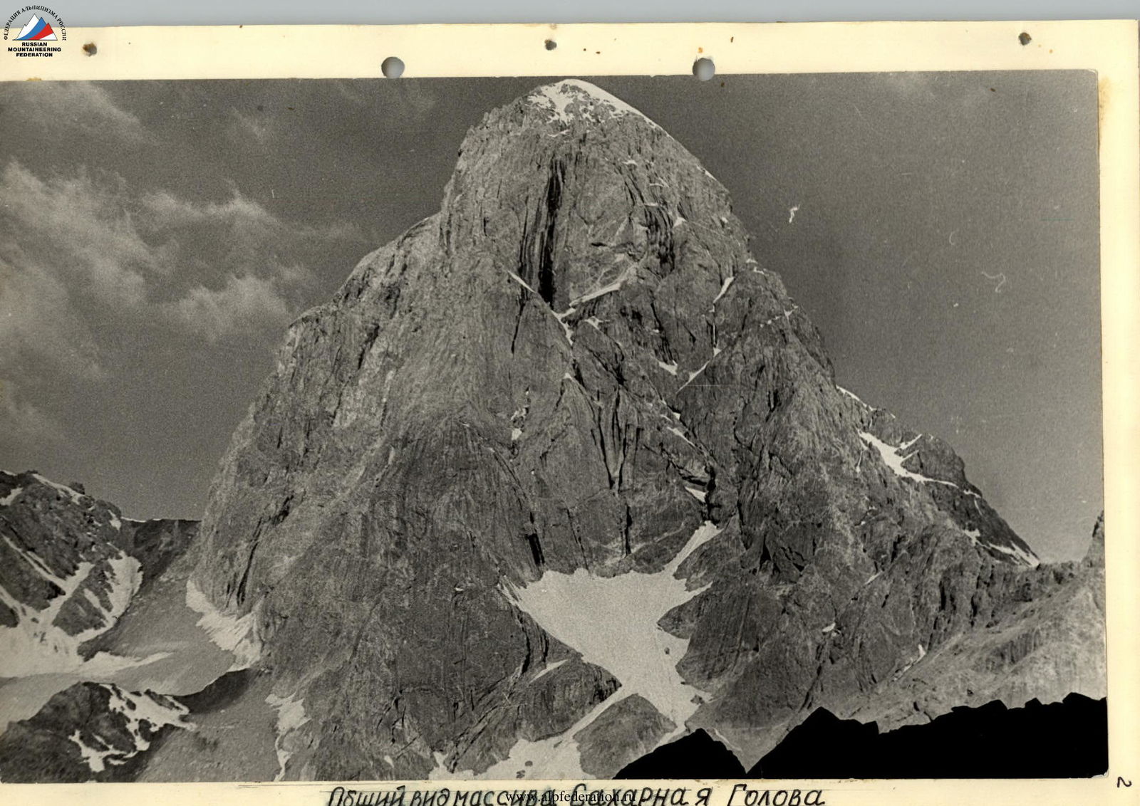
Sugar Head 4971 m. Via North-East Ridge
5A category of complexity
Team of Malachite Sports Club on a group voucher to Varzob Alpine Camp.
Team captain - Yushkevich Vladimir Ivanovich - 1st sports category
Team members:
- Kolesnikov Alexander Alekseevich - 2nd sports category
- Sergeev Yuri Olegovich - 2nd sports category
- Stepanenko Mikhail Mikhailovich - 2nd sports category
Senior coach - Dauter Boris Vladimirovich - Master of Sports of the USSR
1975
Geographical and Alpinist Description
Arg Area
(see map "Fann Mountains. Arg River Basin" on page 10).
The source of the Arg River is located at the Kaznok glacier at an altitude of about 3500 m. The river, which begins here under the southern slopes of the Energia peak, is called Kaznok. After Kaznok turns south and merges with the Akhbasay River after the Teppa meadow, the Arg River begins.
Then it receives the rivers: Biob, Anzak, White Bars (left), Southern Chandara (right). After merging with the Karakul River at the Sarytag settlement, it is called Sarytag and flows into Lake Iskanderkul.
The Arg River basin is bounded to the north by the East Fann Range from Zindon peak to Ganzya Bolshaya peak, and to the east by the southern spur of the East Fann Range. The western boundary of the area is the ridge that runs from Zindon peak south to Dukdon Pass and then southeast to the mouth of the Arg River.
Along the northern boundary of Arg, from west to east, are the peaks:
- Zindon (4800 m)
- Energia (5105 m)
- Four-thousanders - Zmeya, Fizkultura, and Sport
- Gratuleta
- Chinal with Fagitar in the northern spur
- Paykhamber
- Five-thousanders - Zamok (in the northern spur), Chyorny peak, Ganzya Malaya, Ganzya Bolshaya.
However, classified routes to most of these peaks go from other gorges. There is only a 2A category route to Ganzya Malaya from the NW glacier and a 2B category route to Ganzya Bolshaya via the Western ridge.
Along the eastern boundary of Arg, from north to south, are the peaks:
- Krasnykh Zor peak (4930 m) with a route via the southern ridge of Biob Pass, 3B category
- Rabiati-Ziet
- Satsy-Mlak
- Anzlyk
- Kidzal
- White Bars with a route via the southern ridge, 4A category
- Ditya
- peak 3391.
From Biob Pass, a lateral spur runs west with the peaks:
- Biob (1B category)
- Kaltsit (2A category)
Along the western boundary of Arg, from Zindon, are the peaks:
- Kaznok
- Skalnaya Stena (4800 m) with routes 4A, 4B, 5A category
- Blok peak (3A category)
- Moskva (5183 m) with routes 2A, 3B, 4B, 5A, of which only 2A is from another gorge
- Sugar Head (4971 m), with three 4B category routes and one 5A category route.
Additionally, the traverse Sugar Head - Moskva - Blok is classified as 5B category.
Then come the peaks:
- Vuonlo
- Pushnovat (4573 m) with a 2B category route
- Ayni (4575 m) with a 3A category route from Dukdon glacier
- Pila (4600 m) - 3B category via the NW ridge
- Dutandon (4200 m) with a 5A category route.
In the spurs of this ridge, in the center of the area, are the peaks:
- Vilnius peak (4120 m) with a 4A category route
- Arg (4200 m) with routes 1B, 4B, 5A, 5B.
The Arg area has many beautiful peaks, but the most beautiful are undoubtedly Moskva with its red walls, similar in color to the walls of the Historical Museum in Moscow, and Sugar Head with its white snow-ice cap, standing opposite each other in the Akhbasoy gorge.
The team consisting of:
- Yushkevich V.I. - team captain (MK-28)
- Kolesnikov A.A., Sergeev Yu.O., Stepanenko M.M. - team members (MK-214, MK-239, MK-28) chose Sugar Head via the North-East ridge, 5A category, as their ascent objective.
For the first time, the peak Sugar Head was climbed in 1953 by Karaganda climbers led by Martynov, likely from the southwest (currently a 4B category route).
In 1962, Mashkov and Lyapin ascended the peak via the wall from Akhbasoy glacier, and in 1963, four more groups followed the same route (currently a 4B category route).
In 1966, a route was made from Mak Pass via the southern ridge (currently 4B category), and in the same year, a team from the Kazakh Alpine Club consisting of:
- Makhanov V.
- Gizatullin M.
- Golodov Yu.
- Melnikov V.
- Sedelnikov V.
- Yuzhanov Yu.
made the first ascent via the North-East ridge.
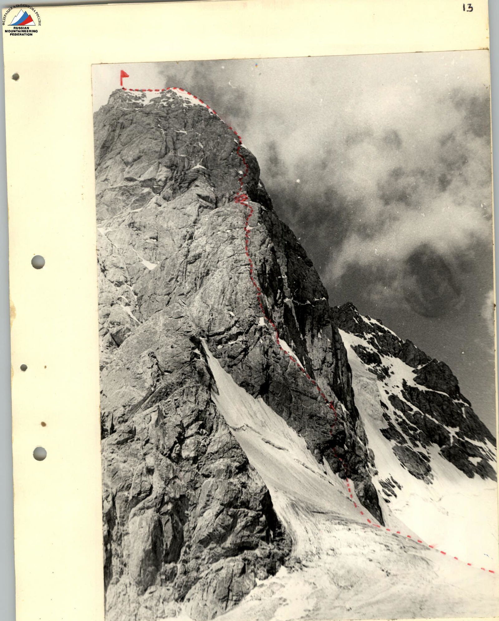 North-East ridge of the peak. Ascent route. Control cairn. Bivouac.
North-East Ridge of the Peak. Ascent Route. 5A category.
Organization and Tactical Ascent Plan
By the time of the ascent to Sugar Head, the team members were in their best physical condition. This was facilitated by a correctly planned schedule of ascents. By the time they arrived in the Arg area, the participants had spent 20 days in the high-altitude zone, conducted training sessions, and made training ascents of 2nd category with a focus on achieving cohesion among team members, and completed four ascents of 3rd and 4th category.
After arriving in the Arg area, the participants rested for two days and then made an ascent via the Eastern ridge to Arg peak, 4B category.
During the three-day rest, preparations were made for the next ascent: observing the team of Shibaev S.A., who were ascending Sugar Head via the southern ridge, 4B category, and scouting the route through a 20x telescope.
After the return of Shibaev S.A.'s team, which became our observation and liaison group, we received advice on the nature of the rocks on the route, the equipment taken on the route, and the descent path.
As a result of studying the description of the first ascenders, consulting at the Varzob Alpine Camp, the experience of the previous ascent in the Fann Mountains to Arg peak, and consulting with Shibaev S.A.'s team, it was decided that all participants would have: boots with rubber soles, two pairs of crampons, a Pamirka tent (instead of the "zdarka" used by Shibaev S.A.'s team), two sleeping bags, and down pants for two participants.
The equipment was distributed so that one backpack weighed only 7 kg. It was assumed that it would be carried by the first climber, but this was not always possible, as it was not always feasible to pass it to the first climber on relatively easy sections, and on difficult sections, the first climber went without a backpack.
Thus, waiting for the return of Shibaev S.A.'s team: Shibaev S.A., Artamonov A.V., Krylatykh E.I., who became the observation and liaison group, and having nine more people in the base camp (within 50 minutes' walk to Akhbasoy glacier) who were eligible to start the 5A category route if necessary, we spent the night of July 12 on the left orographic moraine of Akhbasoy glacier, planning to depart at 6:00.
Ascent Diary
Section R0-R1
From the overnight stay on the orographic left side of Akhbasoy glacier, we cross the glacier and approach the counterfort of the NE ridge of the peak, orienting ourselves by a characteristic rock outcrop in the ridge resembling a "shoe". Overcoming the bergschrund, we ascend a steep (section 1-2) approximately 45° firn slope. Belaying is done through an ice axe.
We exit onto rocks to the left of the "shoe". The first rope team, Stepanenko - Yushkevich, makes the first rock ascent. The second rope team, Sergeev - Kolesnikov, follows. On a ledge, we change our footwear, putting on galoshes. Now, in each rope team, one person wears Vibram boots, and the other wears galoshes.
Ahead are steep, smooth slabs, making climbing difficult. Stepanenko leads the section. Hammering sounds are heard. The rest of the participants ascend via the fixed ropes.
Further, via steep slabs and small walls, we exit onto the ridge. Here is the control cairn; we change the note and continue.
On section 1-2, 9 pitons and wedges were hammered. The section's length is 150 m.
Section 2-3
Along the ridge, directly upwards, the rocks are not steep, strongly smoothed, but the rubber footwear holds well, so we move simultaneously. Belaying is done through pitons. Thus, we cover three rope lengths.
The ridge abuts a 15-20 m wall with a not very pronounced cornice of rusty color. Misha leads. Directly up a diagonal crack under the cornice, then 3 m to the right and up, and the cornice is passed. We find a previously hammered piton.
Further, towards the ridge, along the edge of snow and rocks, we exit onto the ridge, which ends in a small ledge at the base of a 30 m rusty wall.
To our left, we see a wide snow-covered ledge; to our right, the N wall of Sugar Head peak drops off. On this section, 5 rock pitons and 4 wedges were hammered.
Section 3-4
We discuss options for passing the wall. The wall is very steep, about 80-85°, with microscopic holds. Misha leads, ascends 10 m, and, standing on a small ledge, hangs a ladder. With the ladder's help, he ascends 1 m up and exits into a smoothed internal corner. Up the right part of the internal corner, directly up and to the right, onto a small platform. After a few minutes, we hear the command: "Ropes ready!". The second rope team ascends to the platform. We pull up the backpacks. Water flows down the wall onto the platform. While Misha and Yura pull up the backpacks, Kolesnikov collects water and gives everyone a drink in turn. Finally, everyone gathers on the platform. It took 1.5 hours to pass the 30 m wall. On this section, 5 rock pitons and 2 wedges were hammered.
The entire wall requires very difficult climbing and is a monolith with very few narrow cracks. The use of pitons and petal hooks is recommended.
Section 4-5
From the platform, along a narrow inclined ledge 10 m to the right and up, under the base of a 50 m internal corner. Sergeev leads. Up the corner, directly up 35-40 m, to a small ledge. Climbing is difficult. Via the fixed rope, the rope team Stepanenko - Yushkevich ascends and continues directly up the internal corner. The internal corner is behind us. Everyone gathers on the ledge. On this section, 8 rock pitons were hammered.
Section 5-6
We move simultaneously. We cover three rope lengths and reach a small snow-covered ledge. From the ledge, to the right and up, orienting ourselves by a small "gendarme" in the ridge, we pass 100 m. From the gendarme, to the left and up, 150 m to a wide snow-covered ledge. Movement on this section is alternating; the rocks are steep, smoothed, with belaying through pitons. On this section, 9 rock pitons and wedges were hammered. The ledge has a convenient spot for an overnight stay.
17:00. We hammer pitons, hang ropes, tie ourselves in, and start setting up for the night. After a persistent half-hour effort, an excellent platform is ready.
Below, we see tents where the release officer, B.V. Dauter, and the backup group are located. Despite direct visibility, there is no communication, but we are not worried, as we know we are clearly visible through a telescope.
We prepare dinner, eat, and immediately fall asleep.
The next morning, we rise at 7:00 and depart at 8:00.
Section 6-7
Sasha Kolesnikov leads. Directly up steep slabs, then 20 m to the right, we exit onto the ridge. Along the ridge, 150 m, via rocks of medium difficulty with alternating small walls, we exit under a 4-5 m wall.
Via the wall, onto an inclined ledge under the base of a gendarme. We bypass the gendarme on the left and, via a not very pronounced couloir, exit under the base of a snow-covered, very steep internal corner. On this section, 8 rock pitons were hammered.
Section R7-R8
Up the internal corner, 40 m, via difficult rocks, then via a groove 30 m to a large snow-covered ledge. Climbing is of medium difficulty. Movement is with the help of jammers on fixed ropes and alternating. On this section, 7 pitons were hammered.
Section 8-9
Along a destroyed ridge crest, directly up, via rocks of medium difficulty, 150 m, we exit onto the snow-ice dome of the peak. To the left, the E walls of Sugar Head peak open up. Via a steep snow-firn slope, three rope lengths up to a small ice wall.
Caution - cornice to the left. The team captain, V.I. Yushkevich, leads. The wall is passed. Further, via a steep firn-ice slope, using ice axe and screw pitons, we pass another three rope lengths. 14:00 - we are on the summit. On this section, 8 ice pitons were hammered.
We contact the observers, remove the note left by Shibaev's team, which made the ascent a day earlier via the 4B category route. The weather, which started to deteriorate three hours ago, has worsened completely. It snows, and a strong wind blows. However, this is the first time during our stay in the Fanns.
We begin our descent via the 4B category route.
Section 9-10
Two 40 m sport rappels, then two 40 m dülfers, and we are on a saddle between Sugar Head and the ridge leading to Krasnaya Moskva peak. From the saddle, holding to its left part, via snow couloirs down to a destroyed terrace. To the right is a narrow ice groove. From the terrace - two dülfers down walls with heavily destroyed rocks onto scree fields. Via the scree fields, first down, then to the left, bypassing the massif of Sugar Head peak, we ascend to Mak Pass. On the pass, we have dinner and, without delaying, descend to the base camp.
Via radio, we are informed that a rope team has been sent to meet us. It's getting dark. In an hour, we are met on the moraine by Buturlin and Semerok. Another 30-40 minutes later, we report to the release officer, B.V. Dauter, about the successful ascent.
On the North-East ridge of Sugar Head peak, 57 rock and 8 ice pitons were installed. The route was completed in 25 hours of walking time, with one overnight stay.