 Photo 1. "Igla" massif - assault camp
Description of the ascent route to v. "Malaya Igla" via the western ridge (first ascent)
Group composition:
- Eliseev G.
- Kelikeldin G.
- Orlov N.
- Khokhryakov G. (leader)
The "Malaya Igla" peak is located at the very beginning of the Zeravshan ridge (Pamir-Alai), approximately 0.5 km south of the "Igla" peak. The height of Malaya Igla is ~4200 m.
To the west from the summit, a short ridge runs out, the northern slope of which is a steep avalanche-prone snowfield (ice at the top), the southern slope is a sheer rock face.
The group of Arzamas-16 gathering, consisting of: Eliseev G., Kelikeldin G., Orlov N., Khokhryakov G. (leader), having preliminarily assessed the ascent route as category 3B difficulty, made the first ascent of this route on July 17, 1969.
The group left the base camp at the Matcha pass. They approached the ridge via the glacier. By-passing the basal crevasses from the right, they ascended via loose snow to a rocky outcrop (a piton is driven in here), and from it to steep rocks. Via a wide internal corner (two ropes), composed of monolithic rounded smooth blocks, they ascended to the ridge. Climbing here is difficult, via cracks between the blocks.
Further movement was along the ridge via large-block rocks of medium difficulty, alternating with steep snow, up to the I gendarme, clearly visible from below.
Numerous steep ascents along the ridge were made with alternate belay via projections.
The I gendarme was ascended head-on - a steep rocky ridge leads to it (rocks of medium difficulty). The ridge of the gendarme ends in a near-vertical wall (10 m) to a snow saddle. Here it is convenient to organize a sport descent by anchoring a rope around a projection. (The wall can be by-passed on the left via the snowfield, but this will take more time.)
From the snow saddle, further movement is to the left via the snowfield, by-passing the II gendarme. The snow is very loose, lying in a thin layer (not more than half an ice axe) on ice. Approximately 30 m further, there are good large stones protruding from the snow, where belay can be organized. Before reaching the stones, steps have to be cut. Further - exit via stones and snow to the ridge (one rope) and movement along the ridge (to the right) via rocks of medium difficulty. A small descent (2-3 m), then a horizontal section of the ridge leads to a near-vertical wall (approx. 4 m), which is overcome via a vertical wide crack. A wedge is driven in here. At the top, there is a convenient ledge with good projections for belay.
Further - exit to a short saddle under the summit tower. The exit can be made:
- via smooth steep slabs (about 10 m, in the middle - a transverse crack for the first in the group)
- by-passing these slabs to the right via two inclined cracks about 2 m long, located one above the other at human height (one for hands, the other for feet) on the sheer part of the southern slope.
Before the saddle, it is convenient to organize belay (receiving from below and releasing to the summit tower), but only two people can fit here.
The height of the summit tower is approximately 30 m. The ascent for the first third is via the ridge coming from the saddle: there are convenient small steps on it (some stones are loose). Here - a small platform, above which - an internal corner with a small amount of snow and ice. A wedge is driven in here. Via the corner - ascent to the summit.
At the top of the tower, there are several small platforms, separated by large cracks and located at several different heights. Here it is convenient to organize descent in any direction.
Time taken for different sections:
- From Matcha pass to the ridge - 1 h 30 min
- Ascent to I gendarme - 2 h 30 min
- Ascent from I gendarme to II gendarme - 1 h
- Ascent from II gendarme to the summit - 1 h 30 min
Total: 6 h 30 min.
Descent from the summit is possible:
- Via the ascent route
- To the neighboring cirque (see photo 1 and map-diagram) (this is how the group descended)
- Via the snowfield (see photo 2) if the snow is in good condition.
When assessing the difficulty category of the route taken, the group relied on their experience of ascents via classified routes:
- v. "Dzhailyk", 3B category difficulty (Caucasus)
- v. "Sarykol-bashchi", 3B category difficulty (Caucasus)
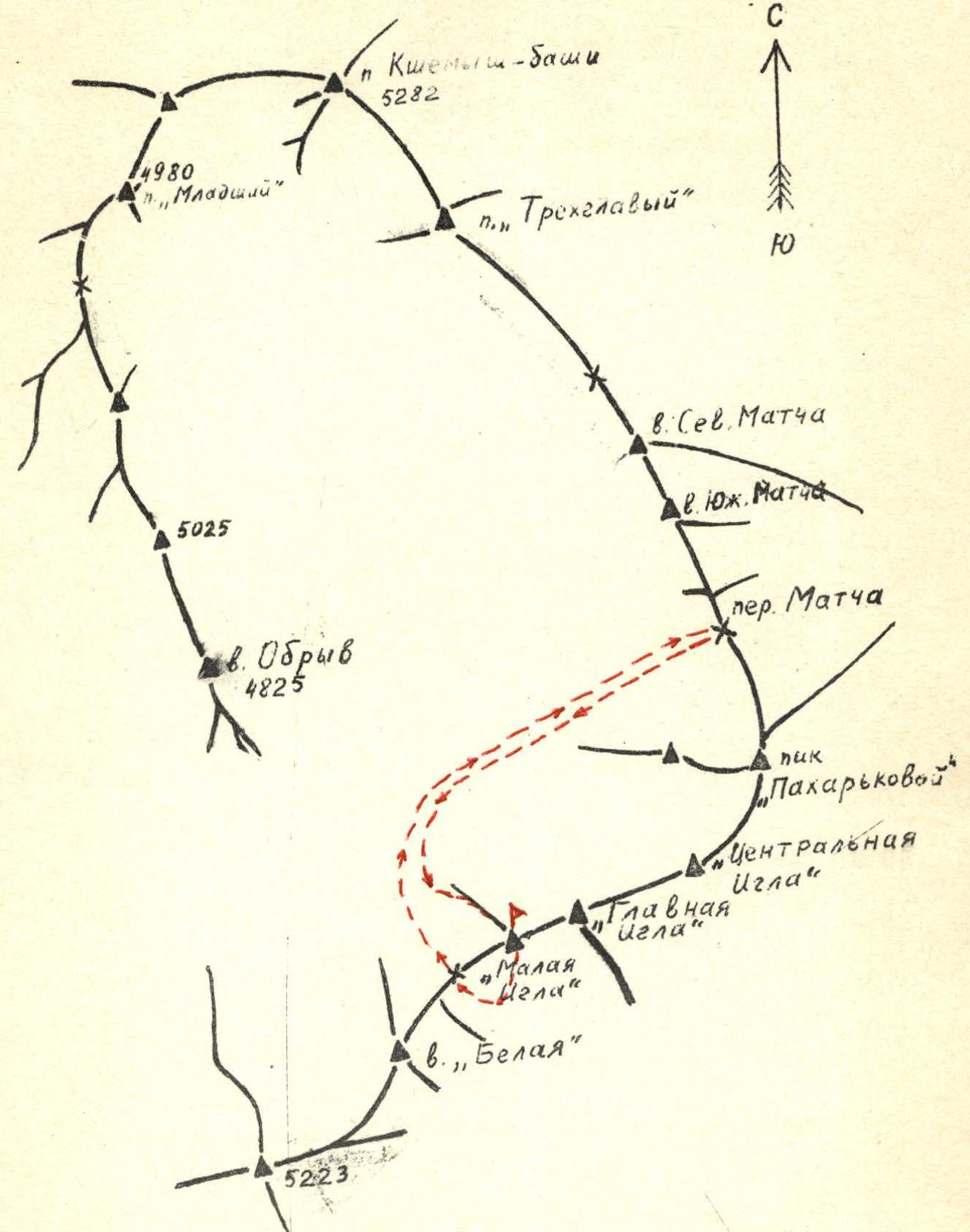 Fig. 3. Diagram of the ridges of the upper Zeravshan forest
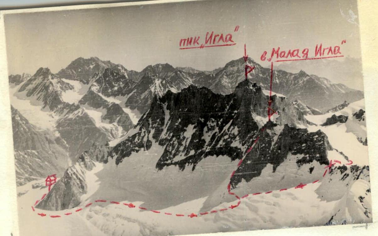 Photo 2. General view of v. "Malaya Igla". I, II - gendarmes.
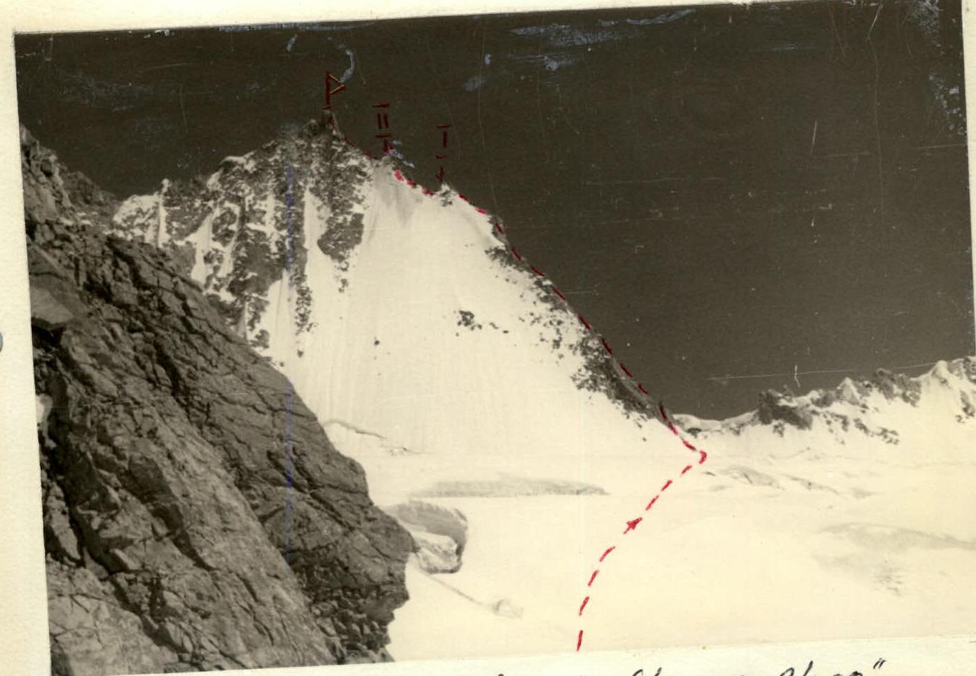 Photo 2. General view of v. "Malaya Igla". I, II - gendarmes.


