Ascent Passport
I. Ascent class - rock
-
Ascent area - 5,3
-
Peak, its height, and ascent route
- Jonatar, 4300 m, via SW ridge
- Estimated difficulty category - 3B
- Route characteristics: height difference 250 m, average slope 55° on ascent, section lengths - I 100 m, II 150 m, III 240 m, IV 20 m, VI m.
- Number of pitons driven: for belay for creating belay points
rock - 34
ice - -
bolted - -
- Number of travel hours - 9
- Number of overnight stays and their characteristics - none
- Surname, first name, patronymic of the leader and participants, their sports qualification: Saprykin Oleg Nikolaevich - II sports category, Zhuravlev Viktor Vasil'evich - CMS, Maneev Nail Ismailovich - I sports category, Zhestkov Vladimir Alekseevich - I sports category.
- Team coach - Zhuravlev V.V., CMS, senior instructor, cert. No. 3319. II. Date of departure and return - September 9, 1979
CMS-35
ascent not easy.
by method for
chief tr.

General view of the peak from NW. The route via NE ridge 4B category difficulty and the approach section to the first ascent route are shown.

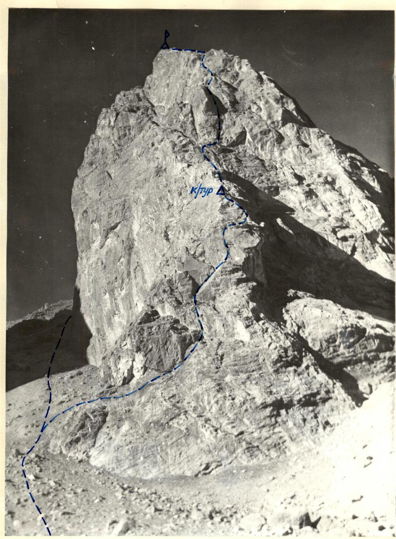
Map-scheme of the ascent area. Conventional signs: Δ - base camp, □ - bivouac, — — — approach route. From Tipa clearing along the right bank of the Kaznok river to its confluence with the Akhbasoy river. From the confluence upstream along the trail, along the left bank of the Akhbasoy river under the NW slopes of Jonatar peak. Here, cross to the right bank of the river via boulders. From the clearing - 1.5-2 hours. After crossing, ascend via the middle talus, bypassing the NW slopes of Jonatar peak to the left. After 1.5-2 hours of ascent, we reach the saddle in the ridge between Alla-ro peak and Jonatar peak. Here, we rope up.
Section R0–R1. Exit to the saddle under the base of the SW ridge via an inclined ledge (40 m). Rocks are heavily fragmented. Rockfall hazard! Alternating movement. Belay via outcrops. Section R1–R2. From the base of the ridge, left and up via an inclined ledge (5 m). To a steep gully (60-65°). Up the gully for 8 m. Rocks are heavily fragmented. Piton belay. Further movement is along the left part of the ridge, without going onto inclined slabs. Rockfall hazard! Piton belay and via outcrops. Movement to a horizontal ledge (35 m). Traverse left from the ridge to a wide crack going up (4 m). Section R2–R3. Up the crack (15 m). Then left onto steep inclined slabs (55°). Slabs are monolithic with convenient cracks for piton placement. Up and right onto a ledge in the ridge (45 m). Piton belay. On the ridge, via an outcrop. Section R3–R4. From the ledge on the ridge, straight up via a steep, fragmented ridge. To a ledge under the base of the wall (30 m). Piton belay and using outcrops.
Section R4–R5. Key section - wall 20 m, 80° steep. Piton belay, ascended left and up to a ledge, 2 x 4 m. On the ledge, a control cairn. Section R5–R6. Movement left of the ledge to the base of an overhanging gendarme (20 m). Rocks are heavily fragmented. Piton belay. The gendarme is bypassed on the left via an inner corner with an exit to the ridge (10 m). Section R6–R7. From the ridge, down a couloir using climbing techniques (40 m) to bypass the gendarme. Section R7–R8. From the couloir, right and up via an inclined slab to a horizontal ledge (20 m). Traverse left along the ledge (40 m). Piton belay and via outcrops. The ledge leads to a wide, fragmented ridge. Section R8–R9. Along the ridge, simultaneous movement to bypass the second gendarme (100 m).
Section R9–R10. From the second gendarme, movement along the ridge through a depression in it to under the summit tower (70 m). Belay via outcrops, alternating movement.
Section R10–R11:
- The summit tower is bypassed on the right via a ledge (40 m) to a chimney with a plug in the middle.
- The chimney is ascended through the hole under the plug. Rocks are fragmented. Belay via outcrops.
- After the chimney - traverse right to an inner corner (10 m).
- Up the inner corner to a ledge (30 m). Piton belay, via outcrops.
- From the ledge, via monolithic rocks - exit to the summit (10 m).
Descent from the summit via the ascent route.
| Date | Designation | Average slope in degrees | Length in meters | Terrain characteristics | Difficulty | Condition | Weather conditions | Belay | Ice | Bolt |
|---|---|---|---|---|---|---|---|---|---|---|
| September 9, 1979 | R0–R1 | 45 | 40 | inclined ledge | 2 | rocks fragmented | good | outcrops | - | - |
| -" - | R1–R2 | 50 | 50 | inclined, gully | 3 | fragmented | -" - | 5 outcrops | - | - |
| -" - | R2–R3 | 55 | 60 | crack, slabs | 4 | monolithic | -" - | 10 outcrops | - | - |
| -" - | R3–R4 | 55 | 30 | ridge | 4 | fragmented | -" - | 4 outcrops | - | - |
| -" - | R4–R5 | 80 | 20 | wall | 5 | monolithic | -" - | 6 | - | - |
| -" - | R5–R6 | 60 | 30 | wall, inner corner | 4 | fragmented | -" - | 5 outcrops | - | - |
| -" - | R6–R7 | 50 | 40 | couloir | 2 | fragmented | -" - | outcrop | - | - |
| -" - | R7–R8 | 45 | 60 | slabs, ledge | 3 | fragmented | -" - | 1 outcrop | - | - |
| -" - | R8–R9 | 10 | 100 | ridge | 1 | fragmented | -" - | simultaneous | - | - |
| -" - | R9–R10 | 40 | 70 | ridge | 2 | fragmented | -" - | outcrops | - | - |
| September 9, 1979 | R10–R11 | 45 | 130 | ledge, chimney, inner corner | 3 | fragmented | -" - | 3 ropes | - | - |
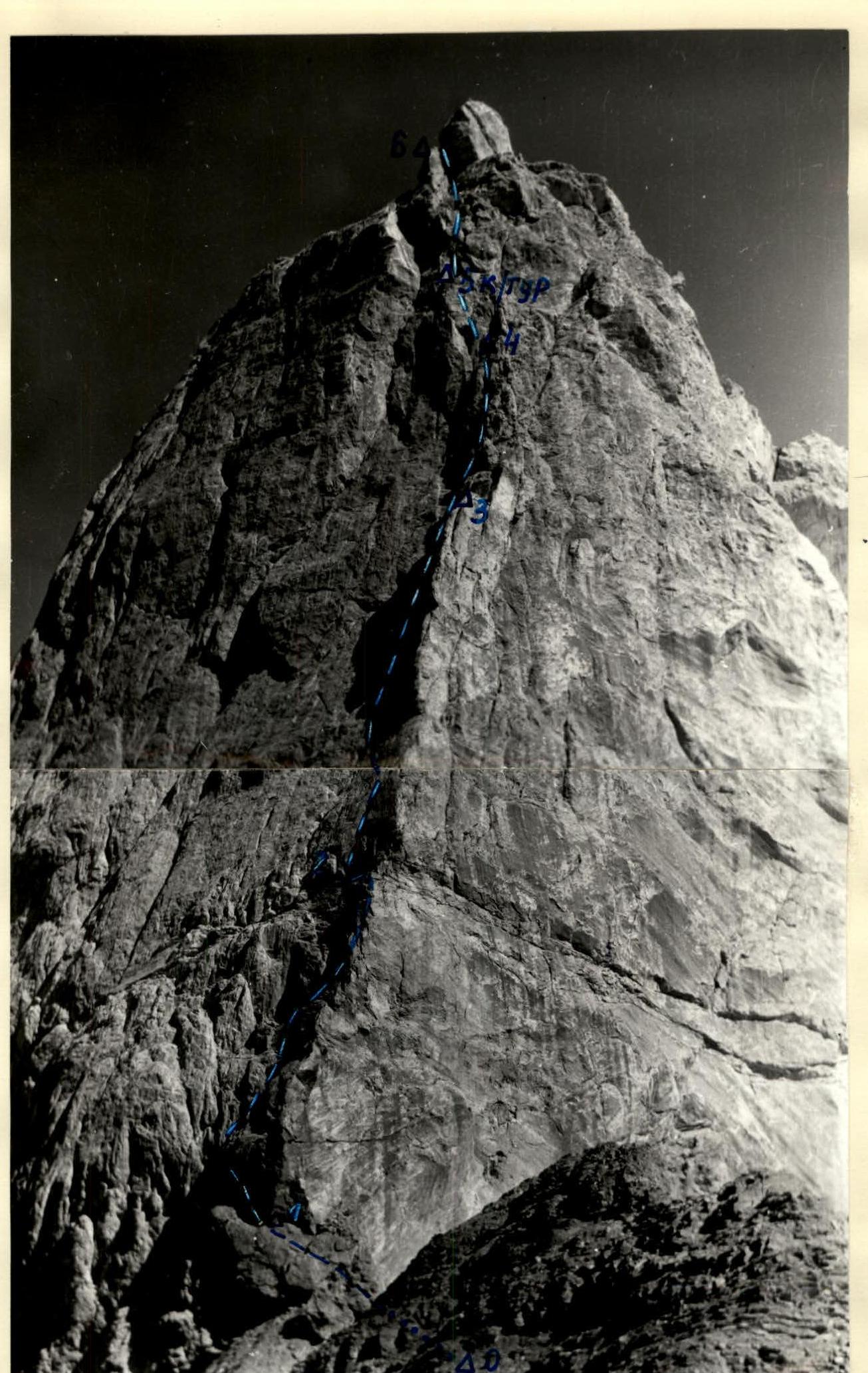
General view of the route, sections R0–R6.

00111

General view of the route, sections R3–R2.