
Ascent Passport
- Climbing category — technical.
- Climbing area, ridge — Pamir-Alay, Zeravshan.
- Peak, its height, ascent route —
- Dukdon Glavny, 5080 m, right part of the northern wall, first ascent.
- Proposed difficulty category — 5B.
- Route characteristics:
- height difference — 1330 m,
- length of sections with 5–6 difficulty category — 704 m,
- average steepness — 72°.
- Pitons hammered: rock — 105 pcs., chocks — 123 pcs., ice screws — 22 pcs., bolt hangers — 0 pcs., artificial footholds — 3 pcs.
- Number of climbing hours — 32 hours.
- Number of bivouacs and their characteristics — 2 bivouacs:
- 1st bivouac — rock ledge, water is melted from ice,
- 2nd bivouac — on the summit, rock ledge, water.
- Surname, name, patronymic of the leader, participants, and their qualification:
- MANEEV NAIL ISMALOVICH — Candidate for Master of Sports, leader,
- ZHURAVLEV VIKTOR VASILYEVICH — Candidate for Master of Sports, participant,
- HASANOV GUMAR MUZANIEVICH — Candidate for Master of Sports, participant,
- ANISIMOV VYACHESLAV IVANOVICH — 1st sports category, participant.
- Team coach — LEONTYEV GENNADIY VIKTOROVICH, Candidate for Master of Sports.
- Date of departure and return:
- departure — August 2, 1980,
- return — August 5, 1980.
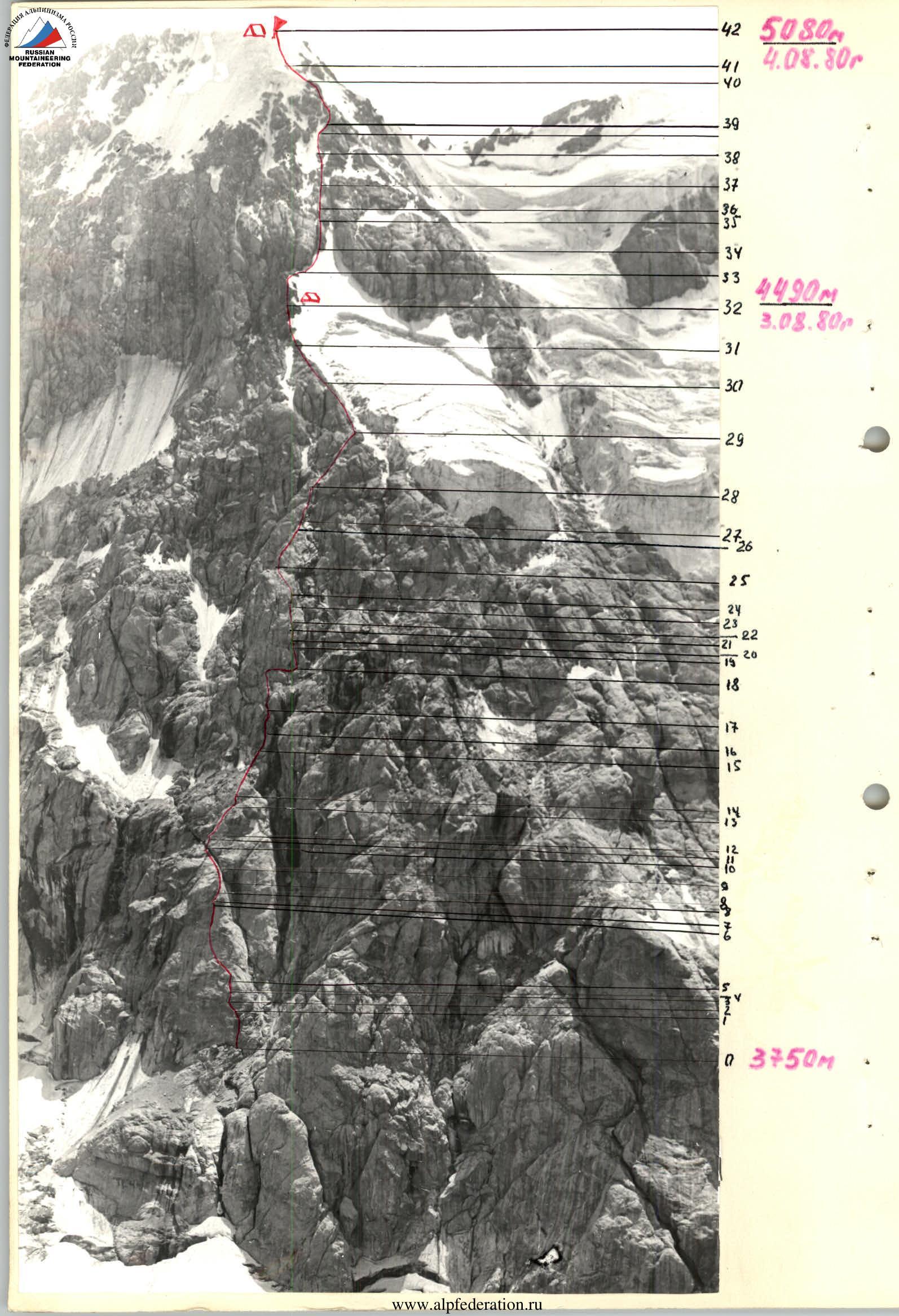
Table of main characteristics of the ascent route
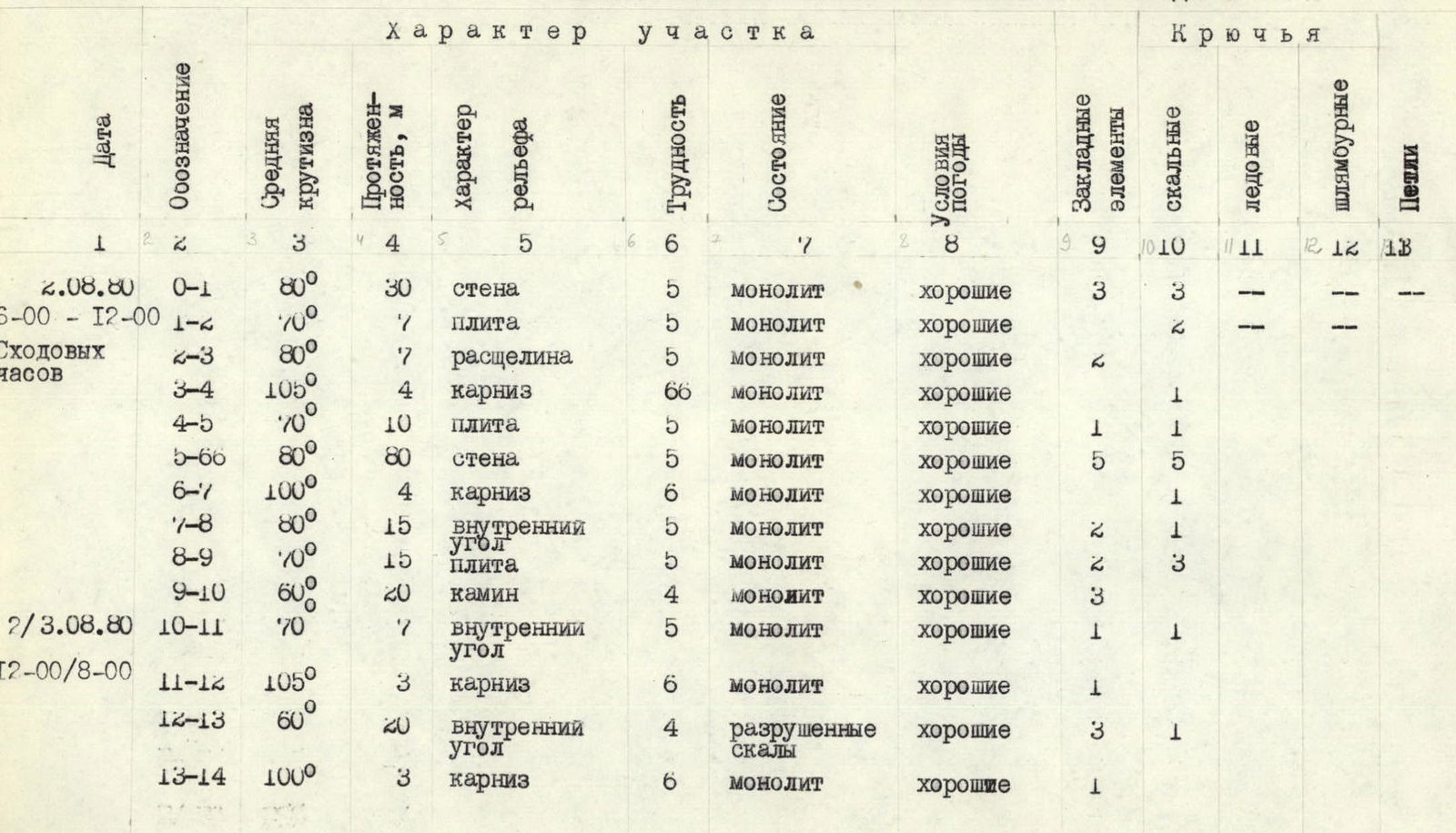
| Date | Designation | Average steepness | Length, m | Terrain type | Difficulty | Condition | Weather conditions | rock | ice | bolt hangers | Loops |
|---|---|---|---|---|---|---|---|---|---|---|---|
| 2.08.80 | R0–R1 | 80° | 30 | wall | 5 | monolith | good | 3 | 2 | ||
| 6:00–12:00 | R1–R2 | 70° | 7 | slab | 5 | monolith | good | 2 | |||
| Climbing | R2–R3 | 80° | 7 | crack | 5 | monolith | good | 2 | |||
| hours | R3–R4 | 105° | 4 | cornice | 6 | monolith | good | 1 | |||
| R4–R5 | 70° | 10 | slab | 5 | monolith | good | 1 | 1 | |||
| R5–R6 | 80° | 80 | wall | 5 | monolith | good | 5 | 5 | |||
| R6–R7 | 100° | 4 | cornice | 6 | monolith | good | 1 | ||||
| R7–R8 | 80° | 15 | inner corner | 5 | monolith | good | 2 | 1 | |||
| R8–R9 | 70° | 15 | slab | 5 | monolith | good | 2 | 3 | |||
| R9–R10 | 60° | 20 | chimney | 4 | monolith | good | 3 | ||||
| 2/3.08.80 | R10–R11 | 70° | 7 | inner corner | 5 | monolith | good | 1 | 1 | ||
| 12:00–8:00 | R11–R12 | 105° | 3 | cornice | 6 | monolith | good | 1 | |||
| R12–R13 | 60° | 20 | inner corner | 4 | broken rocks | good | 3 | 1 | |||
| R13–R14 | 100° | 3 | cornice | 6 | monolith | good | 1 | ||||
| R14–R15 | 60° | 20 | slab | 4 | monolith | good | 2 | 2 | |||
| R15–R16 | 75° | 10 | inner corner | 5 | broken rocks | good | 2 | ||||
| R16–R17 | 80° | 15 | chimney | 5 | monolith | good | 2 | ||||
| R17–R18 | 70° | 20 | ridge | 5 | broken rocks | good | 1 | ||||
| R18–R19 | 85° | 10 | wall | 6 | monolith | good | 2 | 3 | |||
| R19–R20 | 105° | 4 | cornice | 6 | monolith | good | 1–1 | ||||
| R20–R21 | 90° | 10 | chimney | 6 | monolith | good | 1 | 1 | |||
| R21–R22 | 95° | 3 | crack | 6 | monolith | good | 1 | ||||
| R22–R23 | 85° | 10 | inner corner | 5 | rime ice | good | 2 | ||||
| R23–R24 | 90° | 7 | chimney | 5 | monolith | good | 2 | ||||
| R24–R25 | 70° | 20 | slab | 5 | monolith | good | 2 | 2 | |||
| R25–R26 | 65° | 40 | ridge | 4 | monolith | good | 5 | 3 | |||
| R26–R27 | 80° | 10 | inner corner | 5 | monolith | good | 2 | ||||
| R27–R28 | 75° | 40 | wall | 5 | broken rocks | good | 4 | 4 | |||
| R28–R29 | 60° | 60 | inner corner | 4 | broken rocks | good | 4 | 2 | |||
| R29–R30 | 65° | 80 | ridge | 4 | broken rocks | good | 9 | 5 | |||
| R30–R31 | 50° | 80 | ridge | 4 | broken rocks | good | 15 | ||||
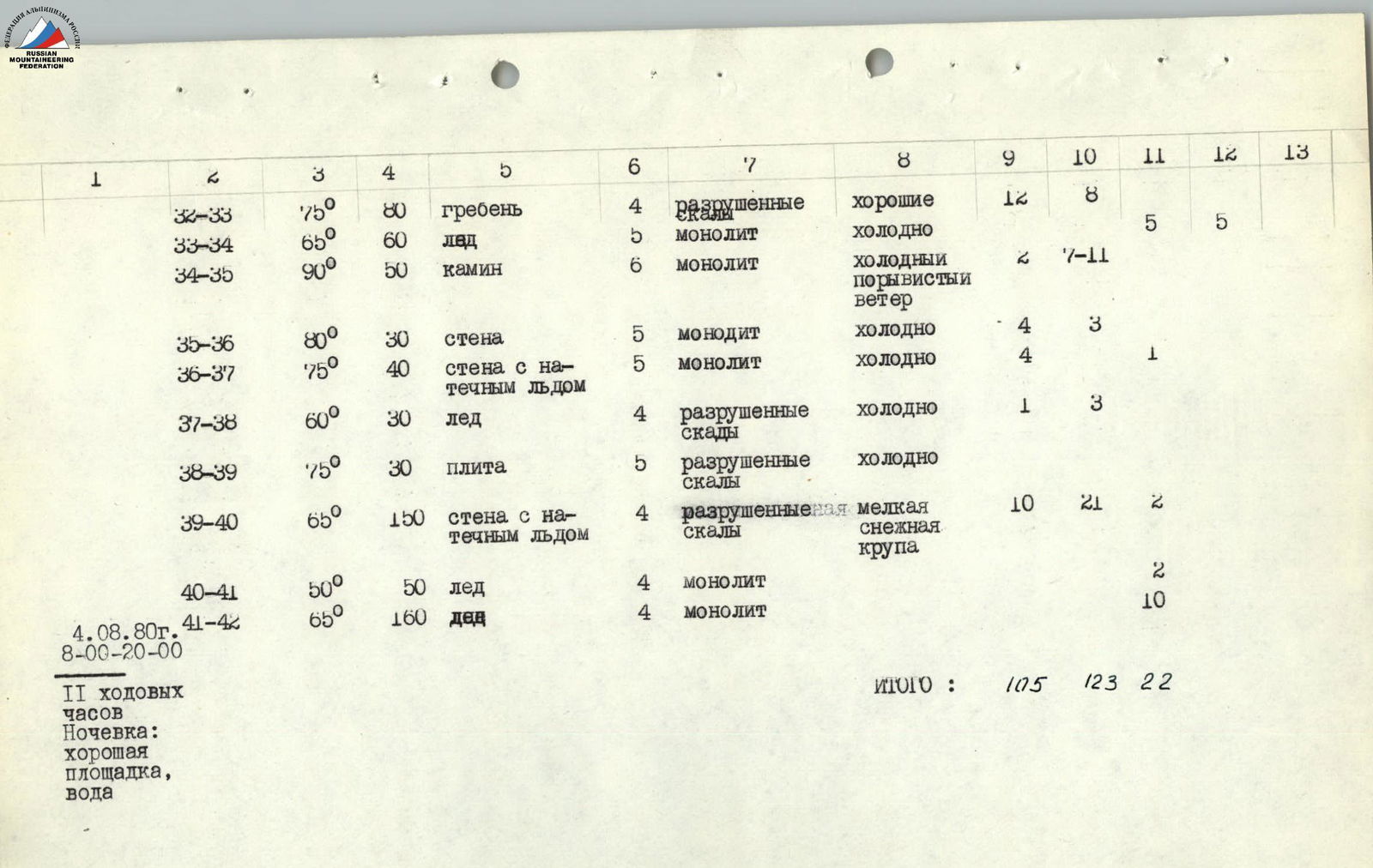
| 3.08.80 | R31–R32 | 70° | 120 | ridge | 4 | broken rocks | good | 5 | 3 | ||
| 6:00–20:00 | R32–R33 | 75° | 80 | ridge | 4 | broken rocks | good | 12 | 8 | ||
| Bivouac site | R33–R34 | 65° | 60 | ice | 5 | monolith | cold | 5 | 5 | ||
| on a slanting ledge | R34–R35 | 90° | 50 | chimney | 6 | monolith | cold, gusty wind | 2 | 7–11 | ||
| R35–R36 | 80° | 30 | wall | 5 | monolith | cold | 4 | 3 | |||
| R36–R37 | 75° | 40 | wall with rime ice | 5 | monolith | cold | 4 | 1 | |||
| R37–R38 | 60° | 30 | ice | 4 | broken rocks | cold | 1 | 3 | |||
| R38–R39 | 75° | 30 | slab | 5 | broken rocks | cold | |||||
| R39–R40 | 65° | 150 | wall with rime ice | 4 | broken rocks | light snow grains | 10 | 21 | 2 | ||
| R40–R41 | 50° | 50 | ice | 4 | monolith | 2 | |||||
| 4.08.80 | R41–R42 | 65° | 160 | ice | 4 | monolith | 10 | ||||
| 8:00–20:00 | Total: | 105 | 123 | 22 | |||||||
| Bivouac: good site, water |
Brief explanation to the table
From the control point, slightly to the right of the overhang, straight up the wall. In the upper part of the wall (R0–R4) — an overhanging cornice (R4–R5), which is passed "head-on". Then up the wall to the left of the wide couloir (R5–R6). The wall in this place is a smoothed rock type "sheep's foreheads" with a small number of holds. The section R0–R6 is passed by the first participant in galoshes, without a backpack (difficult climbing, short overhanging sections).
In the upper part of the wall — an overhang with a crack (R6–R7). Then the wall becomes gentler and leads to a couloir (R9–R10), which has a convenient place for bivouacs under an overhanging cornice.
The sections R0–R10 were pre-processed by the group on the first day of ascent, and a supply of food and equipment was left under the cornice for continuing the ascent.
The cornice is passed "head-on" (R11–R12). Then under the overhanging blocks closing the couloir, to a ledge (R12–R13).
Along the ledge to the right 60 m along the rocks, covered with rime ice, under the inner corner between the blocks. Sections R11–R15 are extremely difficult climbing! ATTENTION! LIVE ROCKS!
Then along the inner corner (R15–R16), turning into a chimney with a plug (R16–R17). The exit from the chimney, through the plug, to a ledge for 2 bivouacs. 2nd control point. Along the wall (R18–R19) with a small number of holds (extremely difficult climbing) — an exit to a ledge in front of the overhanging red wall. The section R15–R19, despite the complexity, is the only correct option for passing the route in this place.
The wall is bypassed on the right along a sloping ledge with a subsequent ascent up through a narrow, steep couloir filled with rime ice. Then along the wall, covered with rime ice (R19–R20, extremely difficult climbing), to a chimney. Along the chimney (R20–R21, jamming!) — an exit to a narrow, sloping ledge. Here is a belay station and rope pull.
From the ledge, through a crack (R21–R22), jamming!, into an inner corner, turning then into a vertical chimney (R23–R24). Then along a slab (R24–R25) to a sloping ledge. Here is a place for a belay station and rope pull.
From the ledge to the left up to a rocky shoulder. Control point. Possible place for a bivouac. Along the ridge (R25–R26) to an inner corner (R26–R27). The corner leads to large blocks. Along these blocks to the left (R27–R28) to a sloping ledge. Along the ledge to the right, bypassing the protruding corner of the wall and crossing the upper part of the wide couloir, we ascend along the inner corner, leading to rocky islands and a glacier (R28–R29). Then to the left along the edge of the ice and rocks, we exit to a steep rocky ridge (R29–R30).
Along the steep rocky ridge (R30–R32) to a sloping ledge under an overhanging finger. Access — finger. Here we decided to organize a bivouac.
On the third day of ascent, we started moving at 8:00 am. From the bivouac site 80 m up the wall. Climbing of medium difficulty, in places very difficult. We approach the "Bastion" — the most crucial section of the route (R32–R37).
The "Bastion" is bypassed on the right along very steep and completely smooth ice (R33–R34), which leads to the beginning of a wide vertical chimney filled with rime ice. Passing the chimney is technically the most difficult and complex section of the route.
First, we ascend along the ice wall up and exit to the right side of the chimney, which is a smoothed, overhanging rocky wall with a small number of holds. Along this wall, extremely difficult climbing using artificial footholds. Here, good self-control and excellent rock climbing skills are required.
In the chimney, there is a strong, cold wind. When passing it, we had to organize a rope pull, although their weight was no more than 7 kg. Passing the chimney noticeably reduced the group's average pace.
Then along the rocks like "sheep's foreheads", with a steepness of 75–80° (R35–R37). Here, in places, there is rime ice and overhanging sections, 3–5 m long. After that, movement along the ice (R37–R38) to a steep rocky slab, covered with water (R38–R39). The movement is still slow, despite the group's intense work.
Then a not steep, but technically complex section due to rime ice R39–R40, which turns into an ice wall (R40–R42). The wall then becomes gentler. This is the summit. It is a snow-ice field with rocky outcrops.
At the summit, we did not find a control point. This greatly puzzled the ascent participants, as the camera shutter had failed, and it was decided to draw a panorama of the surrounding peaks. The drawings are provided in the report.
Comments
Sign in to leave a comment