ASCENT DOCUMENT
- Type of ascent — rock climbing.
- Region of ascent — 5.3.А.
- Peak Vilnius, 4120 m.
- Difficulty category — 3B.
- Route characteristics, length of sections: II, III, IV, V — 400 m, 30 m, 160 m, 120 m.
- Pitons hammered:
| For belay | For standing pitons (ITOs) | |
|---|---|---|
| rock | 13 | — |
| ice | — | — |
| chocks | — | — |
- Number of travel hours — 4 hours.
- There are no overnight stays on the route.
- Stupalov Vladimir Konstantinovich — team leader, 1st category. Smirnov Pyotr Mikhailovich — 1st category. Selivanov Leonid Petrovich — 1st category. Uzhencev Alexander Vasilyevich — 1st category.
- Team coach — Levina L.P., Master of Sports of the USSR.
I. Characteristics of the Ascent Object
Peak "VILNIUS" is a rocky massif with steep cliffs to the east, north, and west, connected only to the south by a narrow pass to the "ZHONOTAR" peak. From this pass, there is a convenient and quick descent via scree to the west. The northern and western walls of the massif were previously climbed by Lithuanian climbers. Our team, while conducting a training ascent to peak "VILNIUS" via the western wall, noticed the southern wall, which could be used to create a purely rock climbing, logical route characteristic of this area, approximately category 3B difficulty, and did so.
II. Organization of the Ascent
Group composition: The sports group that ascended peak "VILNIUS" consisted of first-category climbers with 8-9 years of climbing experience.
Leader: STUPALOV Vladimir Konstantinovich, born 1945, unranked, electrical fitter, Perm.
Group members:
- SMIRNOV Pyotr Mikhailovich, born 1950, unranked, engineer, Perm.
- SELIVANOV Leonid Petrovich, born 1946, unranked, fitter, Perm.
- UZHENCEV Alexander Vasilyevich, born 1941, unranked, fitter, Perm.
III. Organizational and Tactical Ascent Plan
Upon arriving at the "Fann Mountains," the group made a series of joint ascents: 3B category difficulty peak "KHYRS"; 4A category difficulty peak "VILNIUS"; 4B category difficulty peak "ARG"; 5B category difficulty peak "SAKHARNAYA GOLOVA" via the pillar and the right counterfort.
Having planned to make a first ascent via the southwest wall, the group took:
- bivouac equipment
- food for one day
Communication with the base camp was maintained via the "VITALKA" radio station.
The group had the following equipment:
- main rope — 2 x 40 m
- rock pitons — 12 pcs.
- carabiners — 10 pcs.
- hammers — 2 pcs.
- first-aid kit — 1 pc.
- "VITALKA" radio station — 1 pc.
The taken equipment proved sufficient for a successful ascent.
The group worked in two teams:
- Stupalov V.K. — Uzhencev A.V.
- Selivanov L.P. — Smirnov P.M.
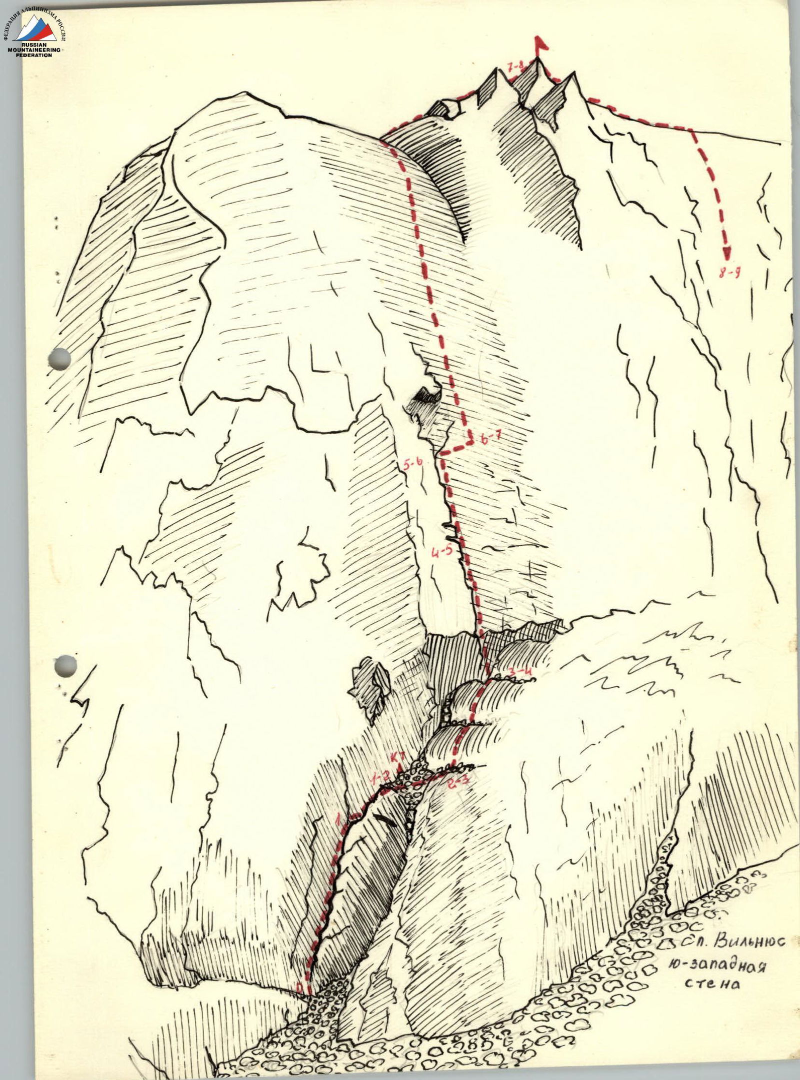
4. Route Description. Characteristics of Sections.
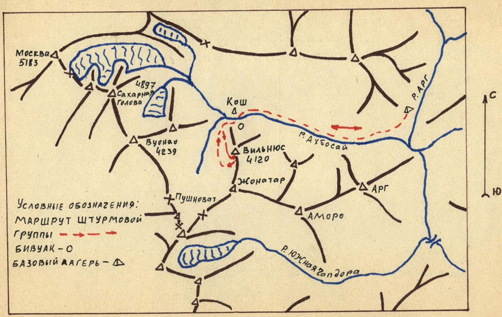
The approach to the route is convenient, taking 3 hours from the base camp by the "AGR" river. The path goes along the right bank of the "ABKHASAY" river. At the koshs, after fording the river (a convenient bivouac spot), the group circumvents the peak "VILNIUS" massif from the right. The ascent is via fine scree to the southwest wall.
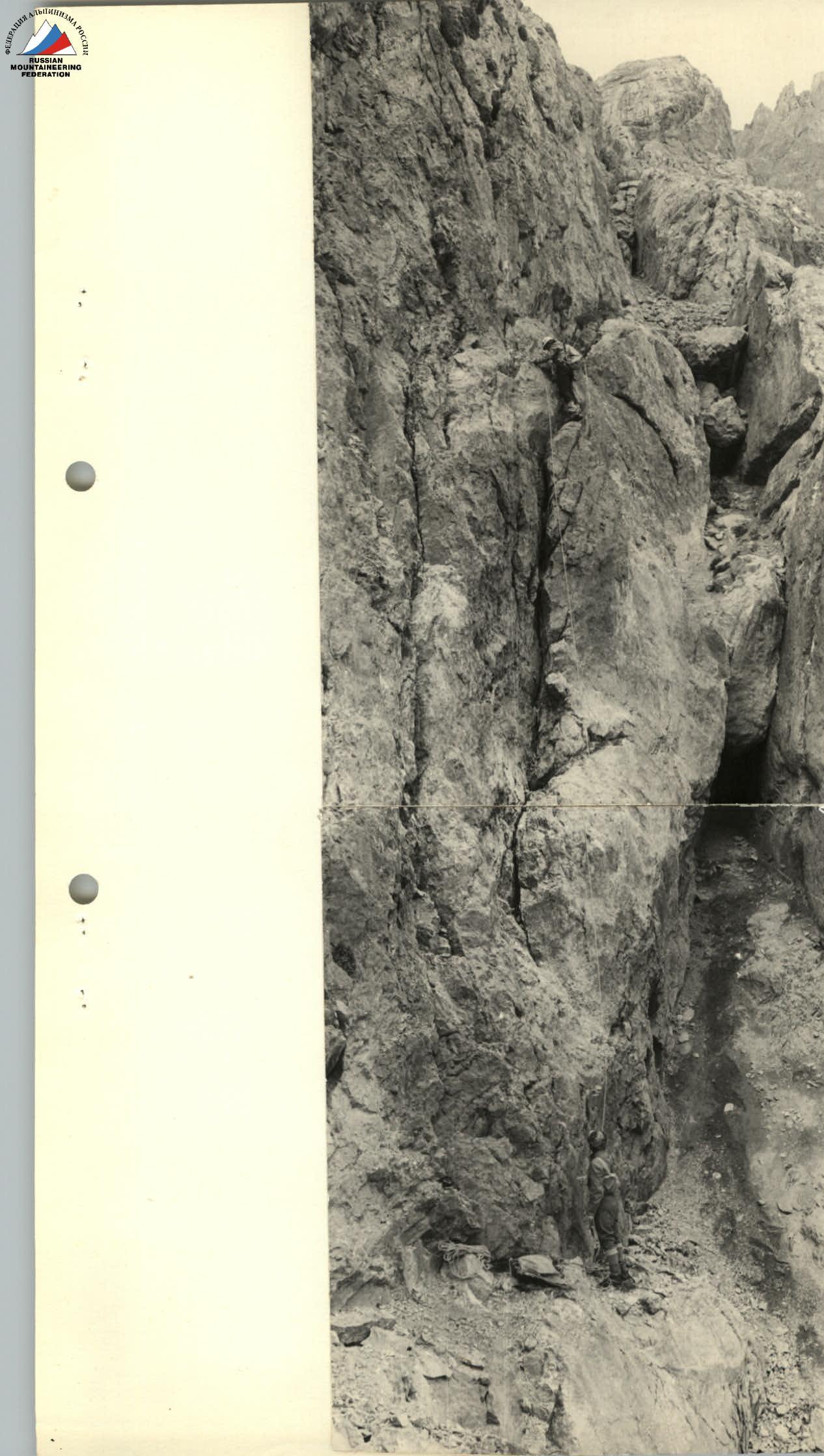
Section 1. The start of the route is on the left side of the wall from a narrow couloir with a plug. On the grey wall against a red-brown background. Upward via a chip with a traverse to the right. Exit to the main ledge. Difficult climbing, belay via a projection, pitons. Wall 80°, climbing 40 m.
Section 1–2. Along the main ledge 10 m with an exit to a rock ridge of medium difficulty. Then, an exit to the next main ledge. To the left under the wall is a control cairn.
Section 2–3. Along an inclined ledge 40 m to rocks resembling "sheep's foreheads."
Section 3–4. Movement across "sheep's foreheads" on friction without handholds 35–40°, 40 m. Then, not reaching a large round stone (continuation of "sheep's foreheads"), 30 m.
Section 4–5. Upward to the left across a black wall with a fissure 80°. Through the fissure 60 m, difficult climbing. Belay in the fissure via flanges, wedges. After 40 m, there is a convenient ledge to change the lead.
Section 5–6. Movement up the wall to a narrow horizontal ledge. Along the ledge to the left, bypassing an overhanging grey "forehead." Ledge 30 m, minimal handholds (psychological climbing), second control cairn.
Section 6–7. Further upward via rocks resembling "sheep's foreheads," landmark — an overhanging stone. Wall 160 m, 50–60°, climbing on friction with micro-holds. The wall leads to the northwest ridge.
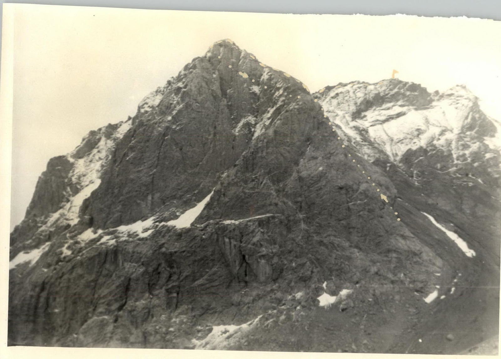
Section 7–8. Along the destroyed pre-summit ridge 400 m, which ends with two elevations. Between them 150 m. On the second elevation is a control cairn — this is the summit.
Section 8–9. Descent via scree along the wall of the ascent.
5. Conclusions
The ascent participants were well-prepared to overcome the route. Therefore, the route was completed in a short time. Everyone acted cohesively and attentively.
ROUTE ASSESSMENT: The route is interesting, technically quite challenging, rockfall-safe, and gave everyone a pleasant impression. Difficult sections of the route alternate with simpler ones.
Recommendations:
- Climb the route in valenki (felt boots).
- Choose dry weather.
The climbed route will be a good training before wall ascents.
Team leader — (STUPALOV) V.K.
Table of Characteristics of the Route to Peak "VILNIUS" via the Southwest Wall, 3B Category Difficulty.
| Sections | Steepness, ° | Length, m | Tech. diff. | Belay | Movement | Duration, min | Pitons hammered |
|---|---|---|---|---|---|---|---|
| 0–1 | 60 | 40 | 5 | Piton, projection | Alternating | 40 | 6 |
| 1–2 | 35 | 40 | 3 | — | Simultaneous | 10 | — |
| 2–3 | 20 | 40 | — | — | — | 10 | — |
| 3–4 | 40 | 40 | 3 | — | — | 10 | — |
| 4–5 | 60 | 60 | 5 | Flanges, wedges | Alternating | 40 | 8 |
| 5–6 | 80 | 20 | 5 | Piton | — | 10 | 2 |
| 6–7 | 50–60 | 160 | 4 | — | — | 45 | — |
| 7–8 | 20 | 400 | — | — | Simultaneous | 30 | — |
| 8–9 | 40–45 | — | — | — | — | 30 | — |
Diagram of the Ascent Region and Ascent Route to Peak Vilnius