12 ASCENT PASS
- Ascent class — TECHNICAL.
- Ascent area: – 5.3. PAMIR-ALAI, Zeravshan Range, Malaya Ganza glacier valley.
- Summit — BELY KLJUCH, 4900 m, via south-west face — FIRST ASCENT.
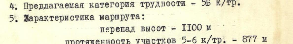
- Proposed difficulty category — 5B cat. dif.
- Route characteristics: height difference — 1100 m length of sections 5–6 cat. dif. — 877 m « — 6 cat. dif. — 127 m « — 5 cat. dif. — 750 m average steepness: 65°
- Pitons driven — 175: for belay for creating artificial anchors. rock 133 20 ice 13 2 bolt 1 2 chocks 6 —
- Number of walking hours — 40.
- Number of bivouacs and their characteristics: 3 lying, snow and ice present.
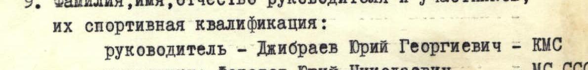
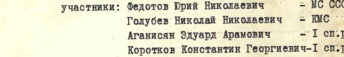
- Surname, name, patronymic of the team leader and participants, their sports qualification: team leader — Dzhibrayev Yuriy Georgievich — CMS participants: Fedotov Yuriy Nikolaevich — Master of Sports of the USSR Golubev Nikolay Nikolaevich — CMS Aganisyán Eduard Aramovich — 1st sports category Korotkov Konstantin Georgievich — 1st sports category Gorodetskiy Vladimir Ivanovich — 1st sports category
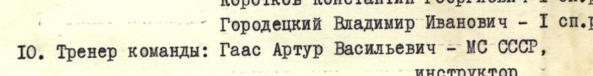
- Team coaches: Gaas Artur Vasil'evich — Master of Sports of the USSR, instructor Shumilov Oleg Ivanovich — Master of Sports of the USSR, senior instructor
- Departure to the route on July 4, 1978, return — July 8, 1978.


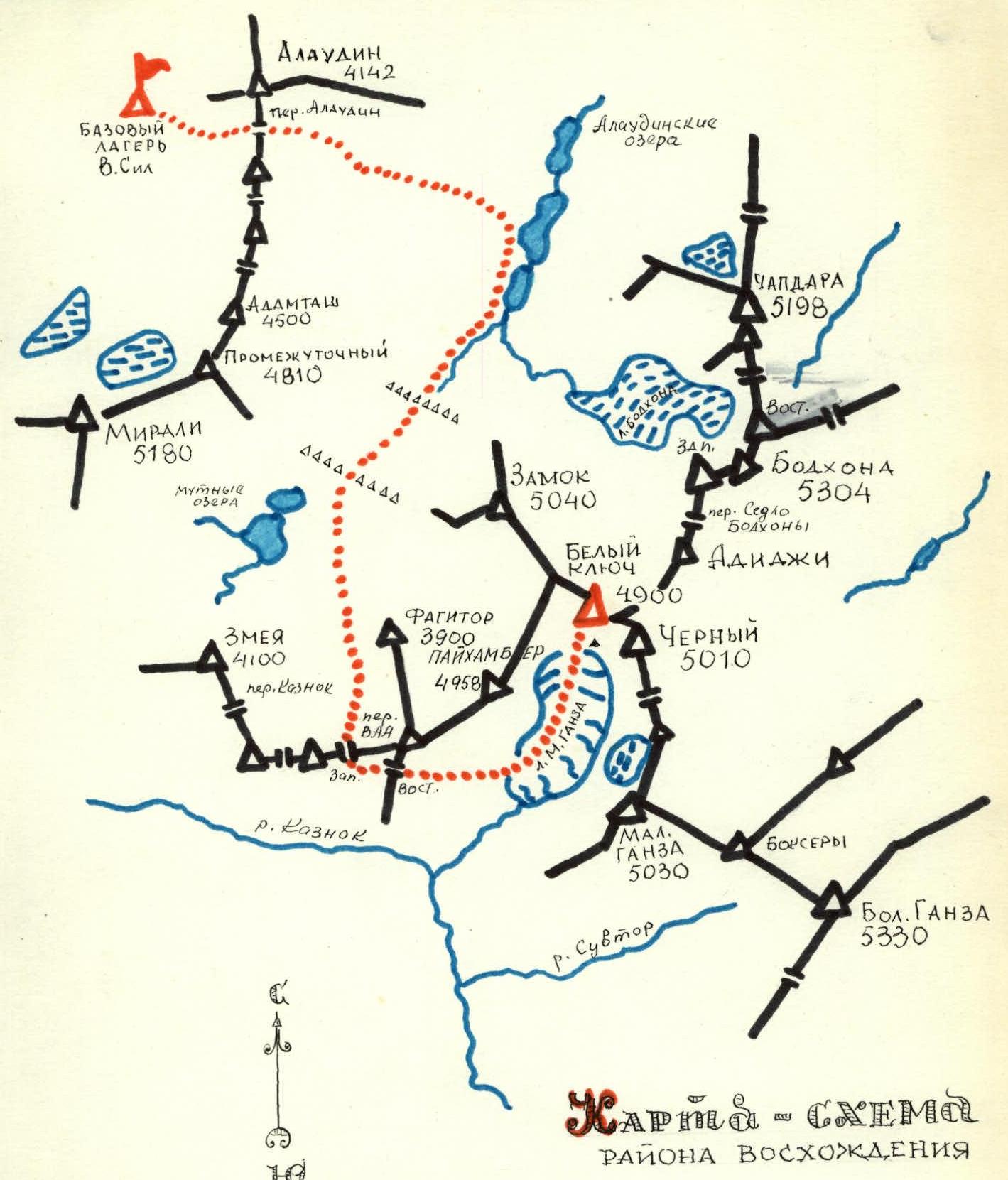
Ascent route: Kulikolonskie lakes – pass Alaudin – Alaudin lakes – Mутные lakes – pass W. and E. VAA (3900 m) – Malaya Ganzy glacier. (See description)
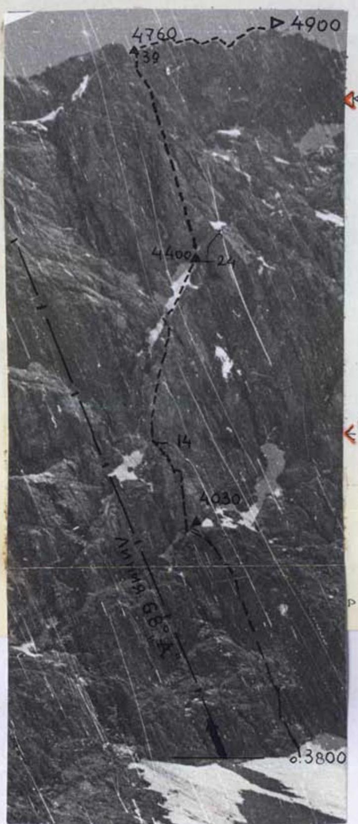
Fig. 4 — table of main characteristics of the ascent route
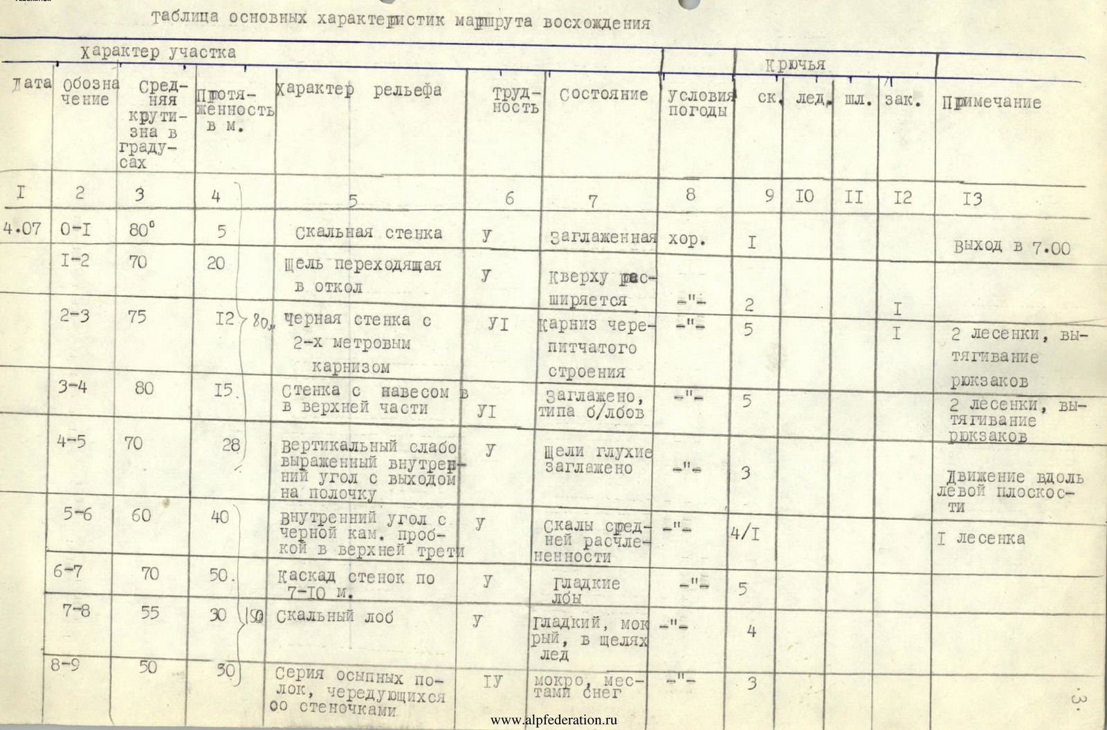
| Date | Designation | Average steepness in degrees | Length in m | Terrain characteristics | Difficulty | Condition | Weather conditions | Pitons: rck. | ice | bolt | chocks | Note |
|---|---|---|---|---|---|---|---|---|---|---|---|---|
| 4.07 | R0–R1 | 80° | 5 | Rock wall | VI | smoothed | good | 1 | Departure at 7:00 | |||
| R1–R2 | 70 | 20 | Crack turning into a slab | VI | Expanding upwards | «–» | 2 | 1 | ||||
| R2–R3 | 75 | 12 | Black wall with a 2-meter corniche of pitted structure | VI+ | Corniche of pitted structure | «–» | 5 | 1 | 2 ladders, pulling up backpacks | |||
| R3–R4 | 80 | 15 | Wall with an overhanging top | VI+ | Smoothed, like b/lbs | «–» | 5 | 2 | 2 ladders, pulling up backpacks | |||
| R4–R5 | 70 | 28 | Vertical, weakly defined inner corner with exit to a ledge | VI | Deep cracks, smoothed | «–» | 3 | Moving along the left plane | ||||
| R5–R6 | 60 | 40 | Inner corner with a black stone plug in the upper third | VI | Rocks of medium fragmentation | «–» | 4 | 1 | 1 ladder | |||
| R6–R7 | 70 | 50 | Cascade of walls 7–10 m | VI | Smooth slabs | «–» | 5 | |||||
| R7–R8 | 55 | 30 | Rock slab | VI | Smooth, wet, ice in cracks | «–» | 4 | |||||
| R8–R9 | 50 | 30 | Series of talus shelves alternating with small walls | IV+ | Wet, snow местами | «–» | 3 | |||||
| R9–R10 | 25 | 1,5 | Ledge under an overhanging marble wall | Snow, gravel | Bivouac organized (snow) at 19:00 | |||||||
| 5.07 | R10–R11 | 85 | 45 | Crack in a vertical marble wall | VI+ | Monolith | good | 8 | 2 | Departure at 8:00 | ||
| R11–R12 | 90 | 5 | Overhang on the wall before exit to an inclined ice ledge | VI+ | Monolith, wet, micro-cracks | «–» | 2 | 1 | 2 ladders | |||
| R12–R13 | 80 | 10 | Rusty wall, at the top an inclined ledge | VI | Icy rocks | «–» | 1 | 1 | 2 ladders | |||
| R13–R14 | 70 | 15 | Smooth slab | VI | Smoothed marble, wet | «–» | 2 | |||||
| R14–R15 | 65 | 80 | Narrow snow-ice inclined ledge with three rock outcrops | VI | «–» | 2 | 5 | Climb-traverse right-up | ||||
| R15–R16 | 55 | 45 | Smooth marble slab | VI | Smoothed, wet | «–» | 4 | CROCODILE | ||||
| R16–R17 | 80 | 10 | Rock step | VI+ | Almost no cracks | «–» | 1 | 1 | ||||
| R17–R18 | 75 | 10 | Smooth rock wall | VI+ | Monolith, wet rocks | «–» | 2 | 1 | ||||
| R18–R19 | 70 | 40 | Rock slab | VI | Wet monolithic rocks | «–» | 5 | |||||
| R19–R20 | 70 | 35 | Inclined convex slab | VI | Wet monolith | «–» | 4 | |||||
| R20–R21 | 90 | 5 | Wall turning into an inner corner | VI+ | Monolith, icy | «–» | 1 | 1 | ||||
| R21–R22 | 50 | 35 | Ice couloir exiting onto a smooth rock slab | IV+ | Icy rocks, ice | «–» | 2 | 6 | ||||
| R22–R23 | 5 | Narrow psychological ledge | Icy | «–» | 1 | Exit to a ledge between the slab and the wall. Bivouac №2 8:00 | ||||||
| R23–R24 | 60 | 50 | Rock-ice couloir turning into an inner corner | VI | Rocks with rime ice | «–» | 5 | 2 | ||||
| 6.07 | R24–R25 | 45 | 30 | Wall with a couloir of inclined slabs | IV+ | Smoothed, snow, ice | «–» | 6 | ||||
| R25–R26 | 65 | 10 | Couloir-slab | VI | Icy rocks | «–» | 2 | |||||
| R26–R27 | 70 | 20 | Inner corner | VI | Monolith, covered with ice | «–» | 4 | |||||
| R27–R28 | 75 | 10 | Rock wall | VI | Monolith | «–» | 2 | 2 | ||||
| R28–R29 | 80 | 20 | Wall | VI | Smoothed monolithic rocks | «–» | 3 | 2 | ||||
| R29–R30 | 60 | 50 | Dissected wall | VI | Snow, ice местами | «–» | 5 | |||||
| R30–R31 | 75 | 30 | Wall with a corniche | VI | Little dissected, smooth | «–» | 4 | 2 | ||||
| R31–R32 | 90 | 20 | Rock overhang | VI+ | Monolith | «–» | 3 | 8 | Ladders, pulling up backpacks | |||
| R32–R33 | 80 | 20 | Rock slope-wall | VI | Rocks with ice | «–» | 3 | |||||
| R33–R34 | 65 | 40 | Rock-ice couloir leading under the base of a 100 m slab | VI | Icy slabs | «–» | 7 | |||||
| R34–R35 | 60 | 30 | Traverse of the wall under the slab | VI | Wet slabs, местами with ice crust | «–» | 4 | |||||
| R35–R36 | 45 | 30 | Inclined couloir | IV+ | Icy rocks | «–» | 4 | |||||
| R36–R37 | 90 | 5 | Wall leading into a rock window | VI+ | Monolith | Overcast, snow | 1 | 1 | Passage between two rock blocks | |||
| R37–R38 | 80 | 10 | Wall | VI | Rocks covered with snow | «–» | 1 | 1 | 1 | |||
| R38–R39 | 60 | 45 | Ridge ascent leading onto the main ridge of the summit | VI | Snow-covered rocks | «–» | 6 | 1 | Bivouac №3 on the ridge. Platform, snow 20–30. | |||
| 7.07 | Waited out bad weather; blizzard — visibility minimal | |||||||||||
| 8.07 | R39–R40 | 40 | 400 | Monolithic smoothed ridge with two dips | IV+ | Icy rocks covered with snow | Fog, wind, snow grains | 15 | Reached the summit at 11:30. Alternating, using rock outcrops. | |||
| Descent to the Adidzhi saddle (3 rappels down a rocky wall and then traverse right-down an ice slope — 1000 m). Route length — 1450 m. Height difference — 1100 m. Sections of 6 cat. dif. — 127 m. Sections of 5 cat. dif. — 740 m. Average steepness — 65°. Total pitons driven — 175, for belay — 155, for artificial anchors — 20, chocks — 8, walking hours — 40, number of bivouacs on the wall — 3. |
Brief description of the approach to the route
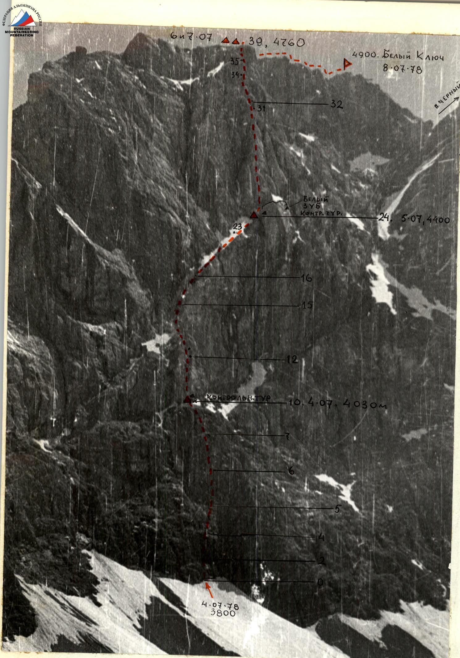
The summit Bely Kljuch is located at the junction of two ridges between the peaks Cherniy, Vost. Zamok, and Adidzhi. It has a height of about 4900 m and drops to the east into the Malaya Ganza glacier cirque with a sheer wall over 1 km high.
The approach to Bely Kljuch from the Allaudin valley, past Mutnye lakes, through the passes West and East VAA around 4000 m high, takes 8 hours.
The southwest face stands out with a huge plane above the glacier, left of peak Cherniy. Ascending this face had not been attempted before our climb. The face is clearly divided into three belts:
- the lower — of black rock;
- the middle — of yellow-gray marble;
- the upper — of reddish marbleized limestone. The upper belt almost everywhere overhangs with cornices.
Brief explanation of the table (description)
The start of the route is left of the smooth "triangle" — the base of the lower belt's counterfort and right of the wide waterfall groove on the wall.
The direction of the route is towards the large gray-white tooth located in the center of the wall under the corniced belt.
On July 3, 1978, the team of V. Gorodetskiy, E. Aganisyán, and K. Korotkov made a "cache" on the Bodkhona saddle. The team of Yu. Dzhibrayev, Yu. Fedotov, and N. Golubev "observed" the wall, studied rockfall-prone areas, and refined the route.
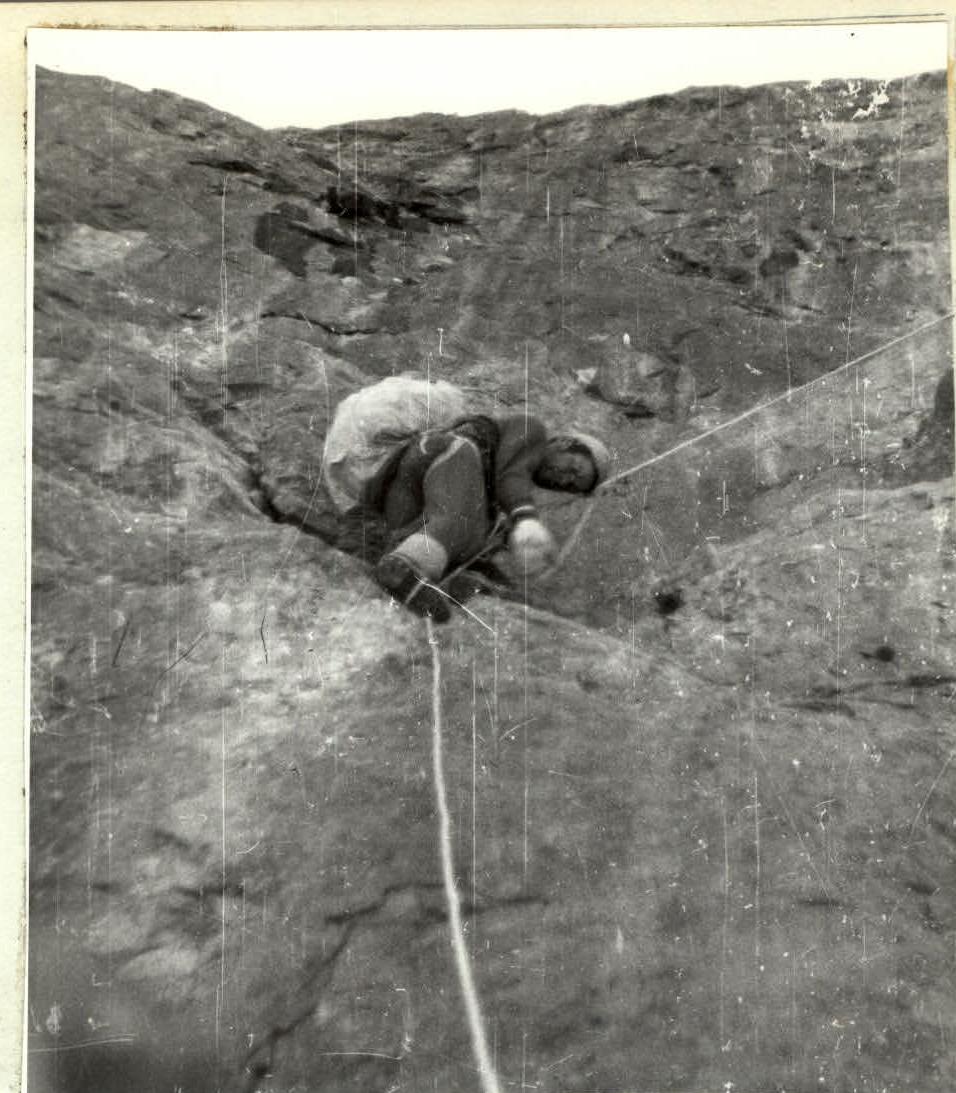
On July 4, 1978, the duo Yu. Fedotov and N. Golubev departed at 7:00 to process the lower belt of the route. At 13:30, the entire group departed. After 100 m of 45° snow, the route begins with a 5-meter rock wall, followed by a transition into a 20-meter crack from left to right, without backpacks. Steepness up to 70°. 8 pitons were driven, and ladders were used twice when passing a 2-meter corniche in the middle of the crack. (Sections R0–R3). The crack leads to a slab (a reception point for one person). Further left, a 10-meter wall, 80°, leads to a smoothed crack with a 2-meter corniche (ladders). After the corniche, another 10-meter wall follows, turning into a rounded overhang dissected by a crack. Here is a large corniche (5 m) — a key point at the start of the route (ladders on artificial anchors), with a platform on the right for two people (reception point). From the platform, slightly left along a steep inner corner (60°) through a black stone plug, another 40 m leads to the exit under a cascade of 10–7-meter walls. (Sections R3–R6). This heavily dissected section leads under a 30-meter rock slab. Little dissected. Few cracks for pitons (Sections R6–R8). After exiting onto the slab along inclined talus and wet ledges, the team reached a platform under the marble overhangs of the second belt. They set up a bivouac at 19:00, having worked 12 hours (see photo). (Sections R8–R10).
On July 5, 1978, they departed at 7:00; exited at 8:00. Immediately follows the key section of the second belt: a 50-meter crack in a vertical wall (see photo). First, onto a rounded outcrop to the left, and then up the crack (2 cornices). 14 pitons were driven for movement on ladders and 10 for belay organization. The exit to the ledge is very difficult, from right to left under the corniche through a black "hole" (see photo). (Section R10–R12). Further right onto a 10-meter wall leading to an inclined ledge. Here are icy marble rocks with poor cracks. (Sections R12–R13). A smooth 15-meter wall was traversed using ladders (2 pieces). Exit onto a snow-ice inclined ledge of variable width with three rock outcrops. 4 times belay was organized through ice "corkscrews". This section (45 m) ends with a smooth 50° marble slab (slippery), turning into a characteristic large rock "Crocodile Head". (Sections R13–R15). Exit to the "head" through a 10-meter wall, 80°, followed by a rope up through a 40-meter "slab". An inner corner separates the "slab" from a 40-meter, 70° monolithic slab. Here it's slippery and wet. 13 pitons were driven for belay. Ladders were used twice, and backpacks were pulled up (Sections R19–R20). After the slab, a sheer 3-meter wall (landing), followed by an inner corner where a belay point, reception point, and backpack pull-up were organized. From the corner, through a rock ascent, rightward traverse of an ice couloir — 10 m above the rock abyss (5 ice pitons for belay and artificial anchors). A smooth slab leads to a 7-meter narrow psychological ledge. (Sections R20–R23). Section R23–R24 begins with a steep, wall-adjacent rock-ice couloir, dropping on the right into the marble belt's sheer faces. They moved, pressed against the left overhangs of the third belt. The rocks had rime ice. Extreme caution was required. The inner corner-couloir ends left of a large square-triangular slab. A good bivouac spot. Time 20:30. They worked for over 12 hours. They assembled a control cairn.
On July 6, 1978, the lead duo Korotkov — Dzhibrayev departed at 7:00. From the bivouac, 60 m along smoothed, icy slabs, crossing a steep couloir from right to left, they approached under the 3rd rock belt. To move up the 3rd belt, they chose a semi-circular, convex part of the wall with several outcrops in the form of "bottles" (see photo). (Sections R24–R26). To approach under the right "bottle", they used a 40-meter inner corner. The rocks were icy. Further on, 140 m of smoothed monolithic rocks on the wall were traversed by hanging fixed ropes. The wall has one 5-meter corniche and a 20-meter overhang (where the group passed on two "stirrups" and pulled up backpacks). Climbing was extremely difficult. (Sections R26–R34). Ropes were hung to the base of the slab. Traverse of the slab's base and exit into an inclined couloir with icy edges. The gully was snow-covered (45 m). From the couloir, right to left along the wall, among overhanging ridge rocks, they found an exit onto the ridge. (Sections R34–R37). First, a 5-meter wall leads into an L-shaped rock window (ladders on chocks). Then an 80° ascent, about 10 m, leads onto a 40-meter ridge with a 60° steepness. Along the ridge, they exited onto the west ridge of Bely Kljuch. Height 4800 m. Bivouac: 20:30. The weather worsened. It's snowing.
On July 7, 1978, snow, blizzard. Visibility minimal. The tents were heavily snowed under. In the fog below, voices were often heard. This was the SIBVO group on the Adidzhi saddle. But the weather didn't allow movement. They waited it out.
On July 8, 1978, without dismantling the tents, at 8:00, they departed along the ridge to the summit. The already smooth rocks on the ridge were icy. They moved extremely cautiously, visibility in the fog was no more than 15 m. Pitons were driven more frequently than required on this ridge. 15 were driven. At 11:30, they were on the summit. (Sections R39–R40). At 13:00, having dismantled the tents, they descended to the glacier under the Adidzhi icefall (3 rappels); further along a steep snow-ice cap, left to right along the northern rocks of Bely Kljuch, 1000 m of traverse-descent onto the Adidzhi saddle, they had a snack. At 14:30, from the Adidzhi saddle, skirting the icy, steep western slopes-walls of Adidzhi, they exited onto the northern rocks of the mountain (careful piton belay, fixed ropes). Here was the SIBVO group and their cache.
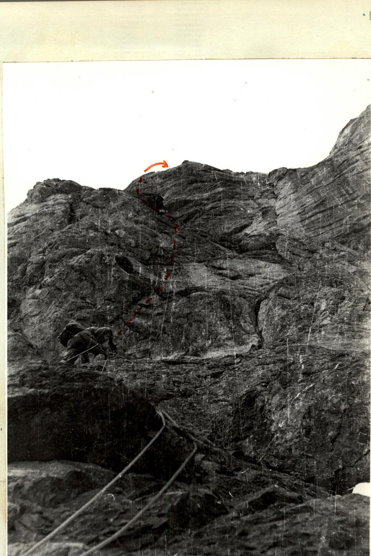
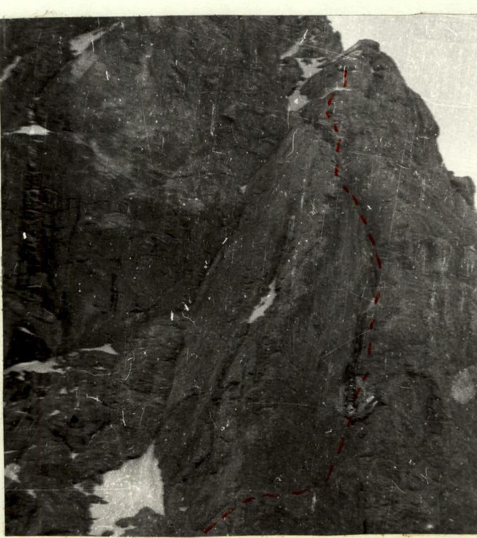
Marble wall of the 2nd belt with a corniche at the top. Section R10–R12
Taken from the bottom of the slope left of the route from the M. Ganzy glacier. Taken from below into the "Slab from under the route".
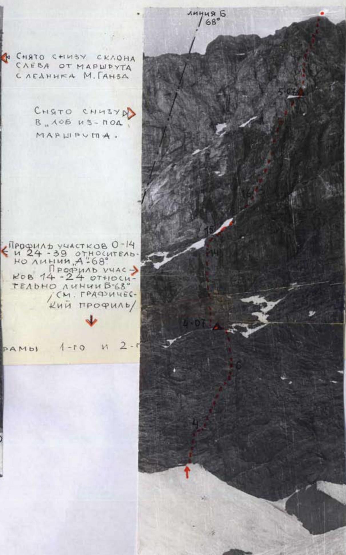
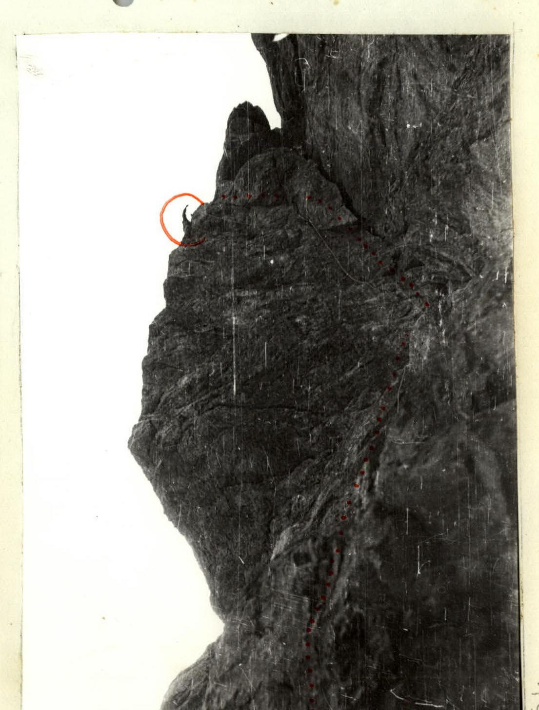
Rock slab of the 2nd belt (so-called "Crocodile Head"). Sections R15–R19.
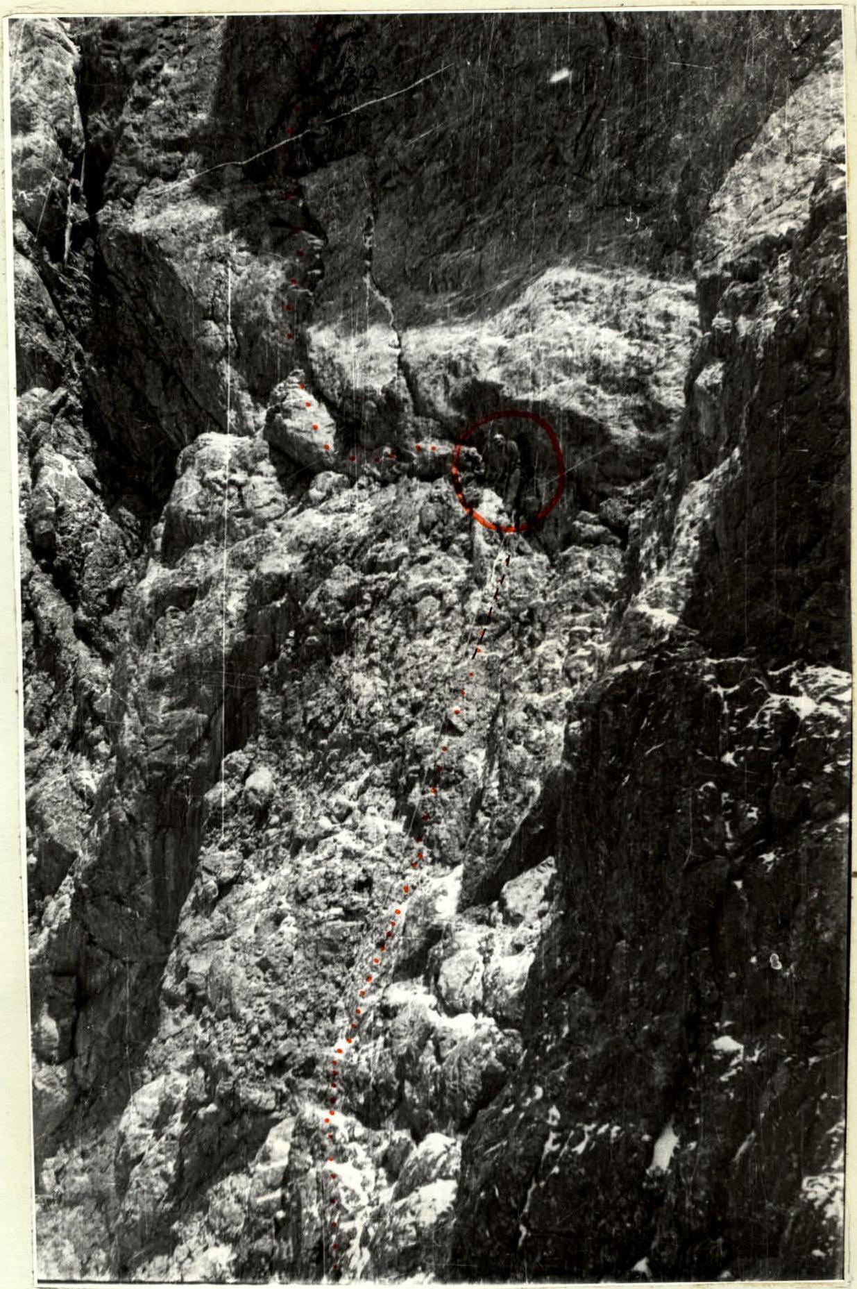
3rd belt. Sections of rocks R30–R32. Snow is falling, participant Fedotov Yu. is visible, and the rope going down is visible. Above, a rock overhang is visible (R32).
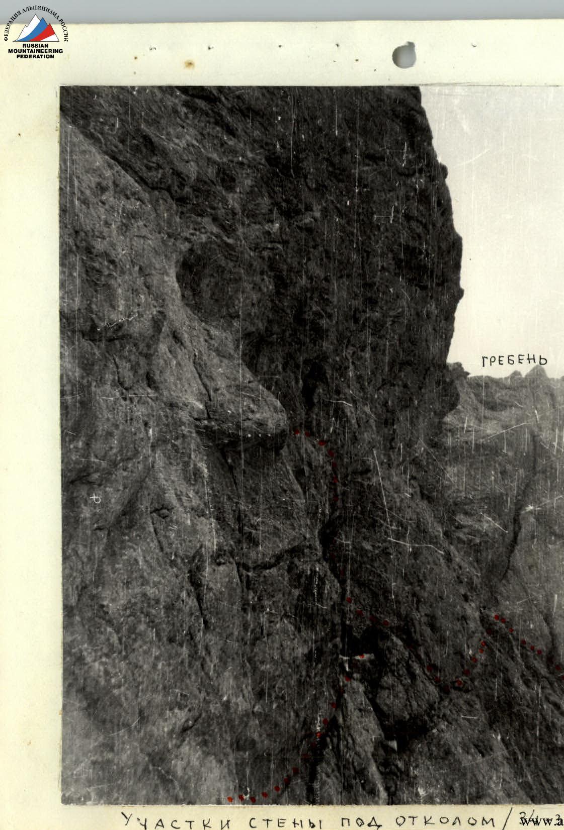
Sections of the wall above the slab (3rd belt). Sections R34–R37.