SUMMIT: BELY BARS (4505 m) Via the southern ridge, 4A category of difficulty, rock
Description of the first ascent made on July 27, 1967 by a group led by Davydenko V.N. (Chelyabinsk region, Miass)
Description compiled by: Davydenko / leader
Chelyabinsk Regional Alpine Federation 1967
1. Introduction
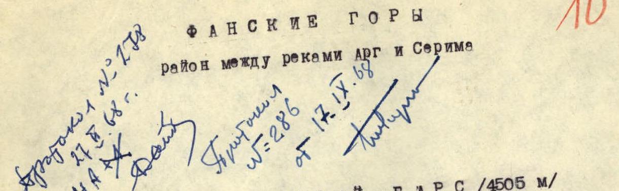
In the ridge located south of the peak Bolshaya Ganza, between the passes Omsk and Anzak, lies the peak Bely Bars (Lalangi Safet - the Tajik name, means "White Leopard").
The first ascent - according to information provided to us by the well-known expert on the Fann Mountains, Mr. Paganutsi N.V. (Karaganda) - was made via the southwestern short edge (route 3B category of difficulty, unclassified) by a group from Karaganda in 1962.
Approaches to the Omsk pass from the northwest from the Arg river area and from the southeast from Lake Iskanderkul take 3-4 hours.
The peak Bely Bars is clearly visible from the area of the peaks Saharnaya Golova, Kaltsit, and Krasnye Zori, and the group's path - from under the Omsk pass on the western side.
PHOTO No. 1 was taken from the area of the peak Biob. The height of the peak according to the altimeter is 4505 m.
2. General characteristics of the peak and route
The peak is composed of metamorphosed limestones. To the north and northeast, it drops off with a wall consisting of smooth slabs covered with ice and snow, and to the west - with a destroyed wall characterized by frequent rockfalls.
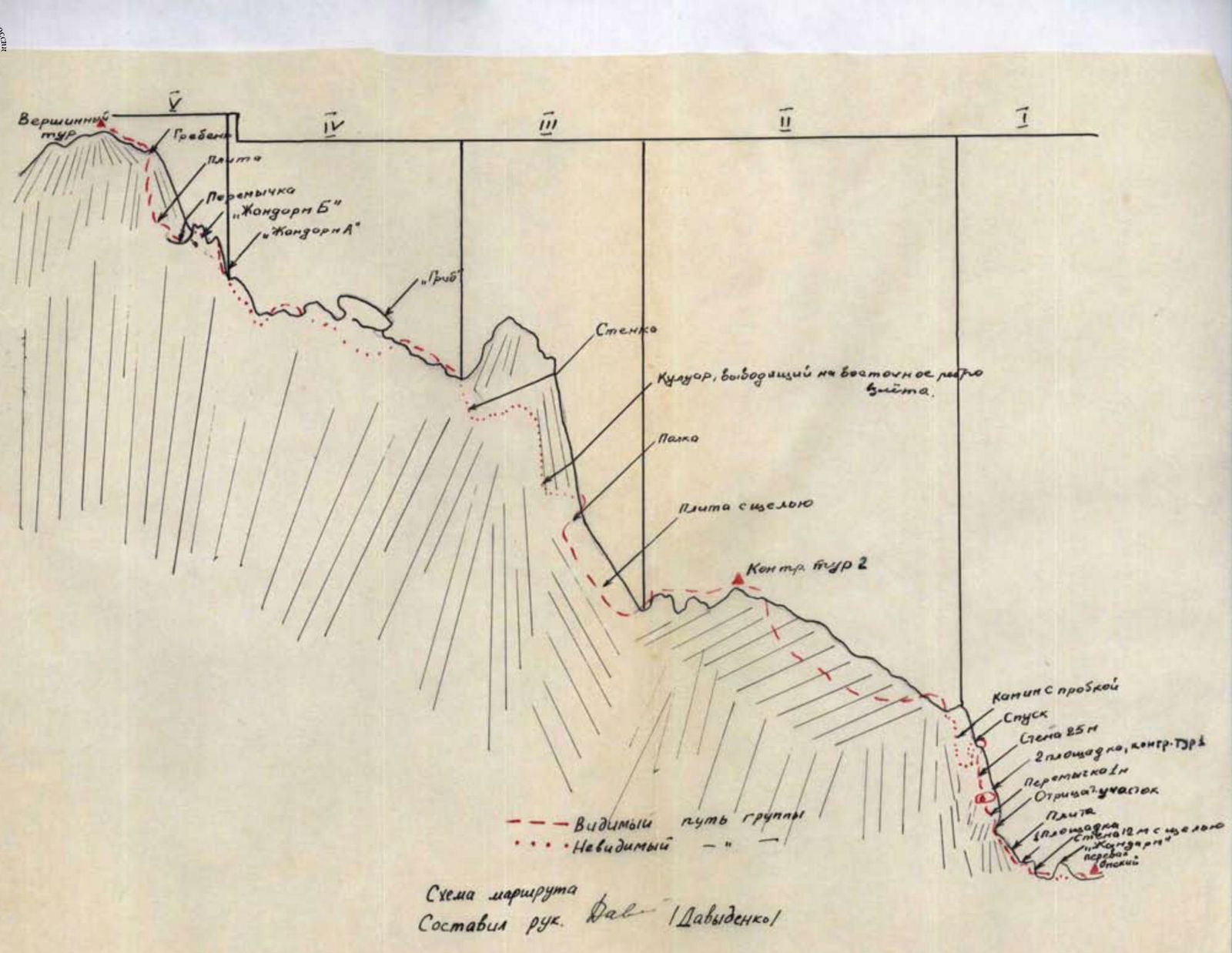
In the ridge route to the peak from the Omsk pass, three main ascents with depressions between them can be distinguished. Between the second and third ascents, a ridge section with a so-called "mushroom" and two gendarmes stands out.
Ice and snow sections encountered on the route are small and do not present difficulties for passage. Some sections of the route are covered with small scree, and there are many loose rocks on the slabs and ledges throughout the route.
Technical description
From the base camp located at the confluence of the Kaznok and Akhbasoi rivers, crossing the Biob river, downstream along the Arg river, traversing the spurs of the ridges of the peak Kaltsit, and left along the Anzak gorge, crossing the river, we reach the western spurs of the peak Bely Bars (July 26, 1967). We bypass them on the left and, following the "Dry stream" bed, ascend to the Omsk pass. From the Arg river to the pass, the travel time is 3-4 hours.
For the last two hours, there is no water. Overnight stay under the pass. There is snow. The route is clearly visible. From the overnight stay to the pass is 45 minutes walk.
On the same day, a reconnaissance of the route was carried out, and the path to the ascent to the ridge of the first ascent was prepared. The ascent to the peak was made the next day (July 27).
I: From the pass cairn along the right wall of the "Gendarme" in a rope team under the steep 12-meter wall. There are almost no holds at the bottom; higher up, it goes along a 10-30 cm crack. Starting from this wall, the insurance is with pitons on the first ascent, which is the key section of the route; the protrusions are unreliable. Above the wall is the first platform. From it, 15 m up the 60° slab to a chip under a negative section. This section (5 m) has poor holds and is passed either on the left along the "forehead" or on the right along the inner corner - in both cases, ladders are required. Further, a narrow isthmus leads to a destroyed wall, above which is the second platform, where the control cairn is located. 50 m of rope rails hung from here the day before by a processing team allow the group to conserve energy on this section and, most importantly, not expose those gathered on the first platform to the threat of being hit by a accidentally dislodged rock. From the second platform, 25 m of difficult climbing along the wall to the exit onto the ridge.
- On the peak, the group found a note from the climbers of the CS DSO "Tadzhikistan" dated July 7, 1967.
- The name "Dry stream" was given by the group.
- There was another option for ascending to the second platform: descend from the pass by 1.5-2 ropes, and then ascend along the wall (about 12 m) and couloir (about 200 m) to the second platform. This option was rejected due to the high rockfall danger of the couloir.
II: Descent (sports) from it 15 m to the right - down, then traverse of the eastern wall of the ridge (insurance 1) along ledges to a smooth chimney (30 m) with a plug, along which we ascend with careful piton insurance onto the ridge. Bypassing the ascent of the ridge on the left, along ledges, we reach the second control cairn, and then, passing several uncomplicated "Gendarmes", we reach the depression before the second ascent.
III: To the right of the ridge line along cracks of a giant slab to a ledge leading to the right behind the edge of the ascent into a rockfall-prone couloir 60 m, which in its upper part tapers into an inner corner close to negative; above the corner are snow-covered platforms of the eastern edge of the ascent. Descending from the edge into the couloir behind the edge, along the wall 15-20 m (rime ice 1), we exit onto the main ridge between rocky "gates" (on the left) and "Gendarme mushroom" (on the right).
IV: Along the ridge to the "mushroom". At the "mushroom", descent 7-8 m to the right - down and exit through a "window" again onto the ridge. There is no other path. The first "Gendarme A" (about 30 m) on this section is overcome head-on (insurance 1).
"Gendarme B" is overcome on the right along two cracks running diagonally along the steep part of the gendarme's wall (one rope).
Descent from the gendarme onto the isthmus 15 m along the wall with a slight negative (10-12 m). The entire difficulty of the descent lies in the fact that it must be done diagonally (careful insurance 1).
From the isthmus along a 50° slab 80 m upwards diagonally. An abundance of small and medium rocks in the depressions of the slab and the impossibility of piton insurance greatly complicate climbing on this section. The slab leads to the eastern ridge. Along it, uncomplicated climbing 40 m to the summit cairn.
Descent along the ascent route (the southwestern ridge as a descent option was rejected due to its rockfall-prone couloirs).
- Very difficult climbing can be used to ascend after traversing the wall of the "Gendarme" to its summit and descend by rappel (25-30 m) down to the isthmus.
Route map Appendix
Compiled by Davydenko
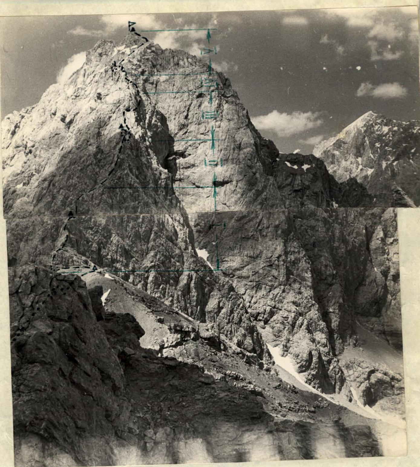
PHOTO No. 2 (author Paganutsi N.V.) Bely Bars and Omsk pass (from the ridge of the peak Ditya) Δ - cairn on the Omsk pass. ...... - invisible path —— - visible path ▲ - control cairns
Table of main characteristics
Route of ascent: to Bely Bars 4505 m along the southern ridge, rock Height difference of the route 505 m (4000-4505 m), including complex rock sections - 100 m, average steepness of the route 85-88°, including complex sections - 80-108°.
Time:
- departure from the bivouac - 6:00
- arrival at the bivouac - 16:40
- walking hours - 9:40
- including ascent - 5:10
Weather conditions: excellent.
| Date | Section | Average steepness | Height extent | Character of sections and conditions of their passage | Character of relief | Technical difficulty | Method of passage and insurance | Pitons driven (rock) | Wedges driven | Note |
|---|---|---|---|---|---|---|---|---|---|---|
| R1 | 60° | 100 m | rocks - crack climbing on a steep slope, use of friction on slabs, negative section, abundance of loose rocks, chimney with a plug. | difficult, very difficult | free climbing, use of ladders, duralumin wedges, pitons, occasionally protrusions with a loop for insurance | 7 | 2 | |||
| R2 | 20° | 80 m | destroyed ridge | easy, average | free climbing, protrusions | — | — | |||
| R3 | 50° | 150 m | use of friction on slabs, crack climbing, climbing in opposition, negative inner corner, rime ice on the last wall of the section | average | free climbing, pitons, protrusions | 5 | — | |||
| R4 | 25° | 70 m | rocks more monolithic, blocks lack holds, protrusions, climbing along cracks. | average | free climbing, pitons, protrusions | 3 | 1 | |||
| R5 | 50° | 105 m | heavily destroyed rocks, slabs, abundance of loose rocks | average | free climbing, protrusions, pitons | 1 | — |
Total on the route 16 rock pitons and three duralumin wedges were driven.
- The "number of pitons driven" column reflects only the ascent path.
- 4000 m - the mark of the Omsk pass, height gain from the "Varzob" alpine camp to the Omsk pass 1950 m.
- The angle to the horizon of an imaginary line connecting the summit and pass cairns.
- On the eve of the ascent day, the processing team spent 4 hours passing to the control cairn on the second platform. Taking this into account, the time spent on the ascent was 7:30, on the descent - 4:30. Total 12 walking hours.
Description compiled by Davydenko V.N.
Route diagram
Compiled by leader Davydenko