- Ascent to the summit of "Palangi-Safed" (White Bars). (approx. 4A) (from Omsk Pass). The summit "Palangi-Safed" (White Bars) (4565 m) is located in the Fann Mountains in the southern spur of the summit Bolshaya Ganza to the east of the Arg river gorge.
The peak is rocky, without snow cover, ice is found in crevices and chimneys facing north. The rocks are very destroyed, but have few cracks for hammering in rock pitons. In the cracks, wedges can be used for belaying.
No notes were found at the summit. The approach to the summit is from Lake Iskanderkul up the Sarytog River, then along the Arg River and then up the Anzak River and its right tributary (along the way) to the Omsk Pass. By the second half of summer, both these rivers (Anzak and its tributary) become very shallow and even get lost among the stones. It is better to spend the night under the pass, where there is water, firewood, and no wind.
The ascent begins to the north of the Omsk Pass, at the beginning of the ridge.
First, we go along a steep internal angle 20 m long and exit to a large site. Along the site, we approach the rocks and, turning right, along a ledge we approach a cleft. We ascend the cleft to a protruding stone, convenient for belaying. From the stone, right and up 20 m along a wide crack, we exit to the second site. On it, a control cairn was left. To the right of the site are cliffs.
Further up 20 m along a steep couloir, and then 40 m up the rocks of medium difficulty. Then left and 35 m along an inclined oblique fissure. Ahead is the first gendarme (Path from the large site to gendarme No. 1 in the photo).
We ascended the gendarme along an inclined shelf and after a 30-meter descent from it along a sharp ridge, we reached a saddle. Behind it is the second gendarme. The second gendarme is bypassed on the right and along slabs with a steepness of 60° we exit to gendarme No. 3, which is bypassed on the left along heavily destroyed rocks.
After passing 40 m along the fissure and 10 m along the rocks, we crossed the ridge. We passed 15 m to the right of it, again crossed it, and approached the fourth (double) gendarme. It was also bypassed on the right and along a steep chimney, we ascended to a new sharp ridge.
Further, one rope length along the sharp ridge, then between two stones and to the right of the stone "mushroom" and "head-on" to the fifth gendarme. From it, a narrow ridge leads to the sixth gendarme.
Overcoming the sixth gendarme is the most difficult part of the route.
Up to half its length, we went to the right along two steep wide cracks and further along them in the saddle behind the gendarme. The distance between the cracks is 0.5 m.
Behind the gendarme, there is a 4 m descent along a negative wall. Careful piton belaying is necessary.
This gendarme presents a great difficulty on the return journey. From this saddle, the path to the summit is clearly visible and represents 6–8 rope lengths of rocks of medium difficulty, with a steepness of 40°.
Descent is by the ascent route. The ascent was made on July 26, 1962, by a sports group consisting of:
- G. G. Gulnev - 2nd sports category, leader;
- V. Ya. Kondratiev - 2nd sports category, participant.
The group was released on the route according to the route sheet of the "Varob" alpine camp. The ascent was continuously monitored by a support group.
The time required to complete the ascent from the beginning of the ridge to the summit is 9–10 hours.
We believe that the ascent should be classified as not lower than category 4A.
A table of the main characteristics of the route is attached.
Route of ascent to the summit "Palangi-Safed" (White Bars)
- Height difference of the route approx. 550 m
- Including the most difficult sections 25 m
- Steepness of the route 45–50°
Table of main characteristics of the route to Palangi-Safed summit
| Section No. | Length, m | Steepness, ° | Nature of relief | Technical difficulties | Method of overcoming | Time | Pitons driven |
|---|---|---|---|---|---|---|---|
| R0–R1 | 20 | 80 | internal angle | medium difficulty climbing, steep terrain | 9 hours | 2 | |
| R1–R2 | 20 | 70 | crack | --"-- | --"-- | 2 | |
| R2–R3 | 20 | 60 | couloir | --"-- | --"-- | 3 | |
| R3–R4 | 40 | 50 | rocks | --"-- | --"-- | 3 | |
| R4–R5 | 35 | 50 | inclined fissure | --"-- | --"-- | 3 | |
| R5–R6 | 50 | – | gendarme 1 | --"-- | --"-- | 2 | |
| R6–R7 | 70 | – | sharp ridge | easy | simultaneous | – | |
| R7–R8 | 55 | 60 | gendarmes 2,3 | medium difficulty climbing, steep terrain | 4 | ||
| R8–R9 | 70 | 50 | slabs, rocks | --"-- | --"-- | 3 | |
| R9–R10 | 50 | 45 | rocks, gendarme 4 | --"-- | --"-- | 5 | |
| R10–R11 | 25 | 70 | chimney | --"-- | --"-- | 3 | |
| R11–R12 | 60 | 30 | ridge, ledges | --"-- | --"-- | 3 | |
| R12–R13 | 40 | – | gendarme 5, climbing, steep terrain | --"-- | 3 | ||
| R13–R14 | 25 | – | gendarme 6, difficult | --"-- | 5 | ||
| R14–R15 | 250 | 40 | rocks | medium difficulty climbing, steep terrain | 12 | ||
| Total | 1400 | 10 hours | 50 |
Date of ascent July 26, 1962.

Approach scheme to the summit Palangi-Safed (White Bars).
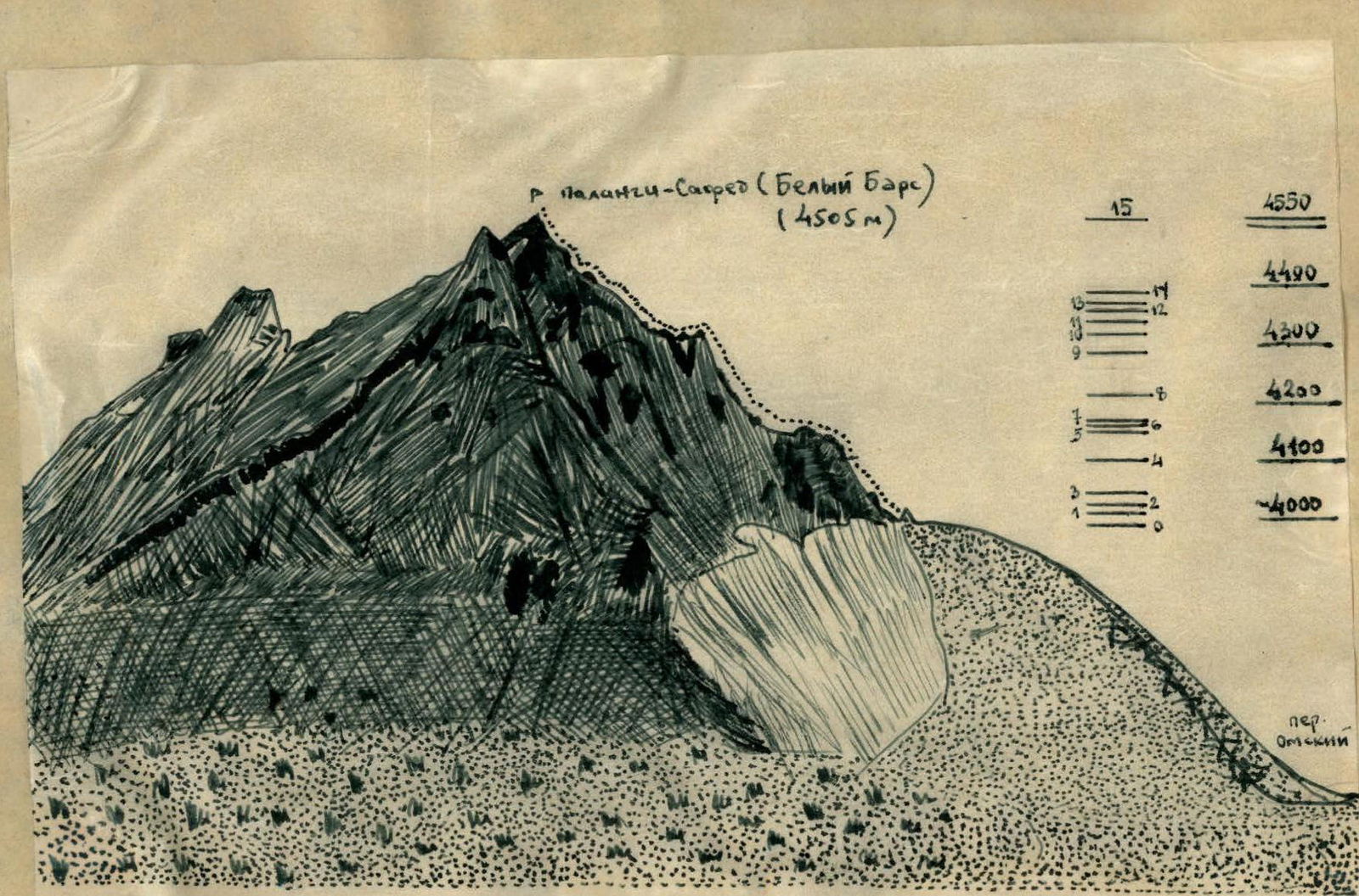
Profile scheme of the route to the summit Palangi-Safed (White Bars).
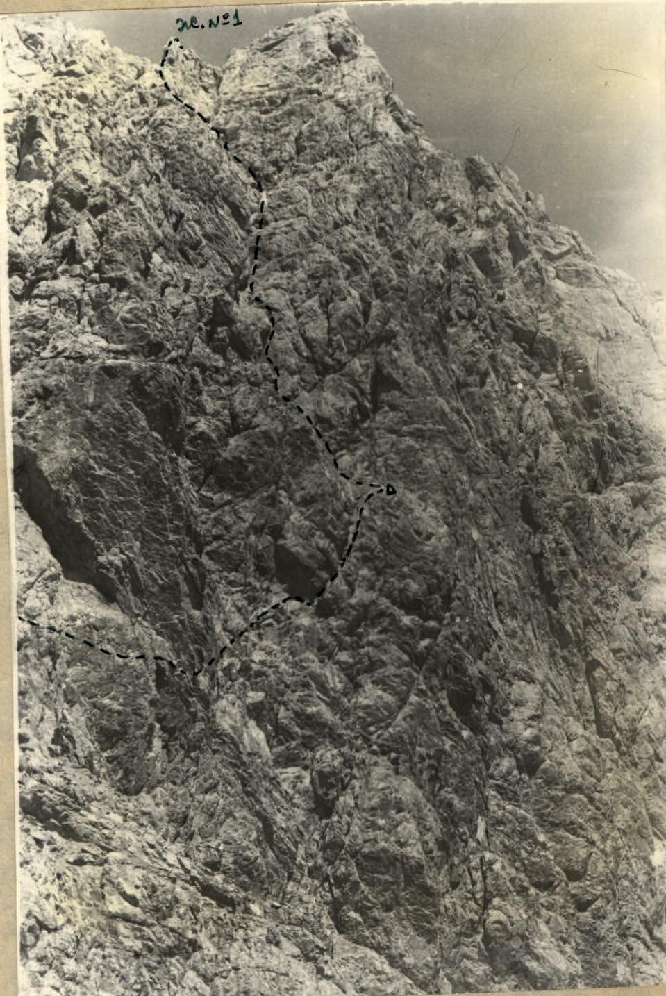
Photograph of the route to Palangi-Safed summit from the large site to gendarme No. 1. The place where the control note is left is visible (9-3-4-5-6).