- Climbing category - rock climbing.
- Climbing area - Pamir-Alay, Fann Mountains.
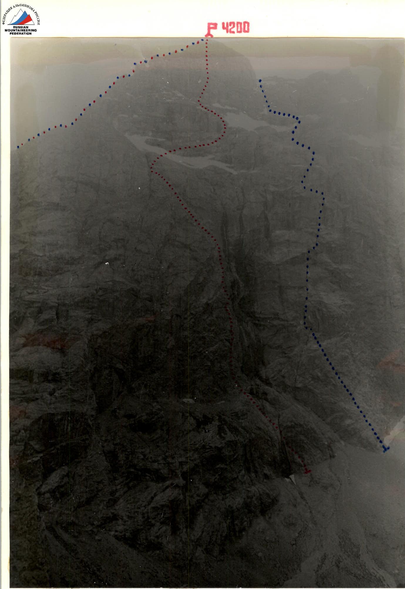
- Peak, its height, climbing route - Arg (4200 m), via the left bastion of the northern wall.
- Proposed difficulty category - 5B.
- Route characteristics:
- height difference - 1300 m
- length of sections with 5-6 difficulty category - 690 m
- average steepness - 75°
- average steepness of the bastion - 84°, 625 m
- average steepness of the summit tower - 72°, 600 m
- Number of pitons driven (for belaying, for creating artificial support):
- rock pitons - 71/6
- ice screws - 5/0
- chocks - 66/16
- Total climbing time - 26.5 hours (excluding descent).
- Number of bivouacs and their characteristics - 1 semi-sitting bivouac (during ascent).
- Team leader, participants, and their qualifications:
-
- Vyacheslav Ivanovich Glushko - Candidate Master of Sports - captain
-
- Vladimir Sergeyevich Balyberdin - Candidate Master of Sports - deputy captain
-
- Team coach - Aleksey Vasilyevich Rusyaev.
- Date of departure and return - September 13-15, 1981.
Tactics for the Ascent
The tactical plan was to ascend the route as quickly as possible with one bivouac on the wall, based on the high individual technical skills of the participants. For this purpose, the team consisted of 2 people. The pair worked with a double rope (40 m). They used ropes: 1 - Czechoslovakia, 2 - USSR. Since the most challenging part of the bastion was an overhanging crack, it was planned to use mainly chocks for belaying there. The ratio of chocks to pitons was 3:5 or 15:25. Considering that the middle part of the route included ice and snow sections, they brought 2 combination hammers, which were equally convenient for working on rocks and ice-snow slopes. On the most challenging sections, the lead climber worked without a backpack, and it was planned to pull it up. For faster and more reliable progress on rocks, the lead climber wore galoshes, while the second climber adapted according to the situation. Based on a favorable weather forecast, the pair ascended without a stove or tent. As bivouac gear, they used:
- sleeping bags
- mats
- spare warm clothing
- headgear and gloves for bivouac
- minimal cookware
- flashlights with spare batteries
Rain jacket - 1; down jacket - 2; down leg warmers - 1; down vest - 1.
The first bivouac was planned under the summit tower. The second - during the descent from the summit.
Two observer groups monitored the team's progress:
-
- L.P. Levina - Master of Sports of the USSR
-
- T.V. Kubonina - Master of Sports of the USSR
- A.M. Sokolov - 1st category
- E.Yu. Voskresenskaya - 2nd category
The first group was based at the "Tepa" meadow, the second - directly below the route. They observed using a 75x telescope and 12x binoculars. The climbers were constantly in the line of sight. Communication between climbers and observers was planned via flares.
Additionally, in case of need, a group climbing nearby routes could assist the team:
- 4A category difficulty
- 5A category difficulty
These groups had radio communication with the observers. The rescue team at the "Varzob" alpine camp, based at the "Tepa" meadow, was authorized to respond to routes of any difficulty category.
Table of main characteristics of the ascent route to Arg peak via the left bastion of the northern wall on September 13-15, 1981.
Route length - 1895 m. Height difference - 1300 m. Average steepness of the route - 75°. Average steepness of the bastion - 84° with a length of 625 m. Average steepness of the summit tower - 72° with a length of 600 m. Length of sections with 5-6 difficulty category - 690 m. Time to reach the summit - 26.5 hours.
Table #1
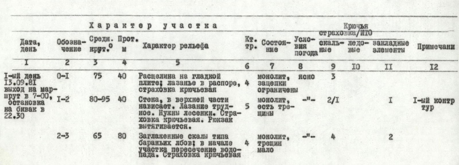
| Date, day | Designation | Avg. steepness ° | Length m | Terrain characteristics | Difficulty category | Weather conditions | Climbing conditions | Rock pitons | Ice screws | Chocks | Notes |
|---|---|---|---|---|---|---|---|---|---|---|---|
| 1st day 13.09.81 departure at 7:00, bivouac at 22:30 | R0–R1 | 75 | 40 | Crack in a smooth slab; climbing in opposition, piton belay | 4 | monolith, limited holds | Clear | 3 | |||
| R1–R2 | 80–95 | 40 | Wall, overhanging at the top. Difficult climbing. Requires ladders. Piton belay. Backpack is pulled up. | 5 | Monolith, cracks present | — | 2/1 | 1 | 1st control point | ||
| R2–R3 | 65 | 80 | Smooth rocks like "sheep's foreheads"; crossing a waterfall at the start. Piton belay | 4 | monolith, few cracks | — | 4 | 2 | |||
| R3–R4 | 70 | 40 | Wall leading to the base of the black overhanging crack. Piton belay | 4 | monolith, loose small rocks | Clear | 2 | 1 | |||
| R4–R5 | 90–92 | 5+5 | Vertical wall, climbing on balance. "Entrance" to the black overhanging crack. Difficult climbing. Backpack is pulled up. | 6 | monolith, holds small and limited | — | 1 | ||||
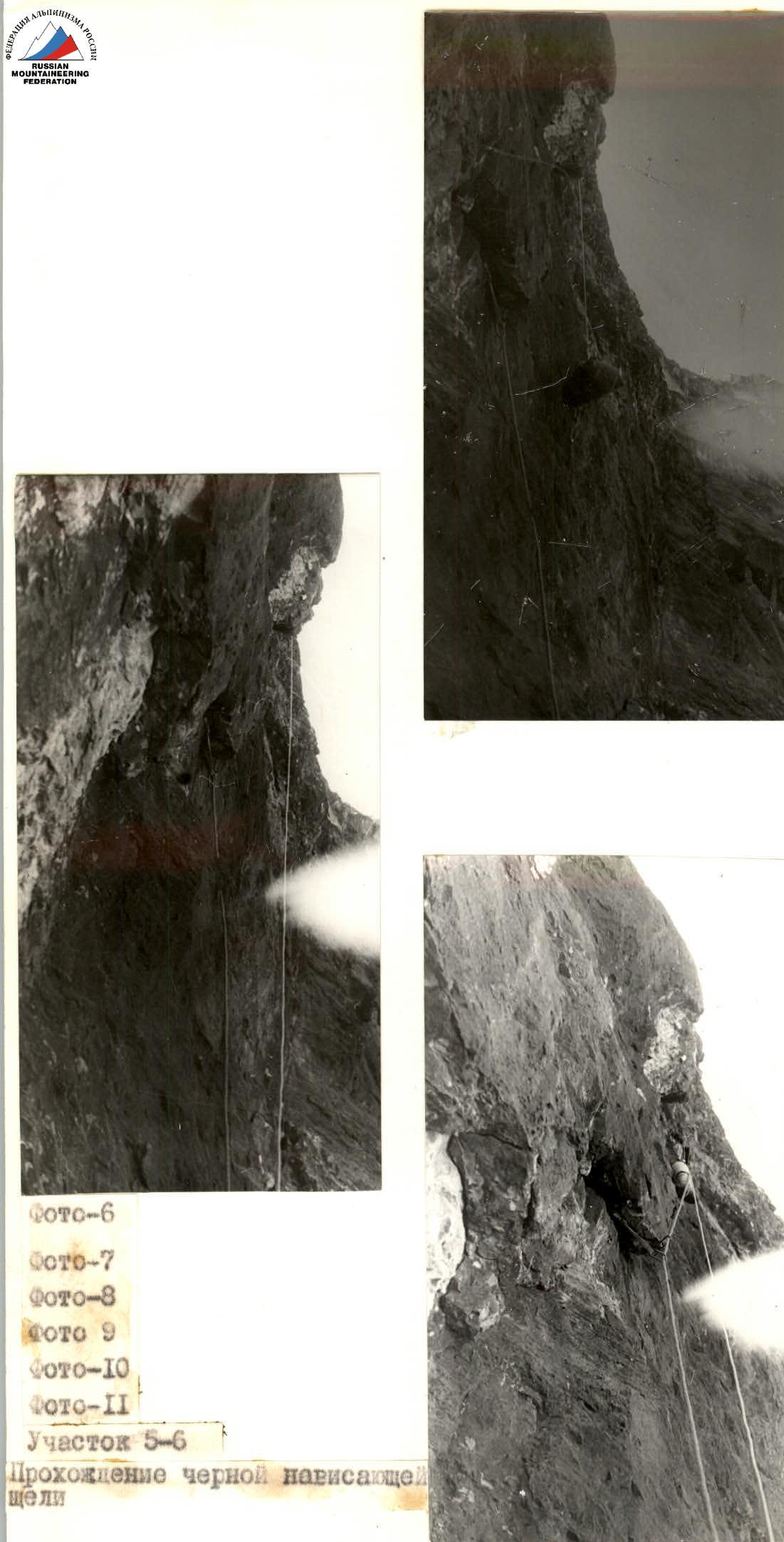
| R5–R6 | 95 | 120 | Overhanging black crack. Very difficult climbing. Requires artificial aids. Piton belay. Backpack is pulled up. | 6 | monolith, wall partially smooth and lacking holds | — | 15 | 5/10 | |||
| R6–R7 | 85 | 60 | Continuation of the crack, rocks lighten. Piton belay. Backpack is pulled up, entrance to a niche. | 5 | Monolith, relief appears | — | 6 | 2nd control point, bivouac possible | |||
| R7–R8 | 100 | 30 | Cornice with a dirty and wet crack. Requires artificial aids. Very difficult climbing. Piton belay, backpack is pulled up. | 6 | MONOLITH, holds limited | — | 1/1 | 2/1 | Bivouac site available | ||
| R8–R9 | 85 | 20 | Vertical wall. Piton belay. Backpack is pulled up. | 5 | monolith, holds limited | — | 1 | 1 | |||
| R9–R10 | 75 | 80 | Slab. Piton belay. Backpack is pulled up. | — | — | 3/1 | 2/1 | ||||
| R10–R11 | 95 | 10 | Cornice. Requires ladders. Difficult climbing. Piton belay. Backpack is pulled up. | 6 | monolith | — | 1/1 | 1 | |||
| R11–R12 | 80 | 60 | Chimney. Chimney climbing technique used. Piton belay. Backpack is pulled up. | 5 | monolith | — | 5 | ||||
| R12–R13 | 80 | 40 | Crack. Piton belay. Backpack is pulled up. | 5 | Monolith | Clear | 1 | 2 | |||
| R13–R14 | 70 | 180 | Ridge. Piton belay. | 5–4 | monolith, cracks present | — | 6 | 6 | Bivouac site available | ||
| R14–R15 | 70 | 80 | Crack on the left side of the ridge. Piton belay. | 4 | Monolith | — | 1 | 3 | |||
| R15–R16 | 60 | 40 | Ridge. Simultaneous movement. | 3 | — | — | 1 | ||||
| R16–R17 | 45 | 60 | Crossing the waterfall's path. Further movement along the ridge. | 2 | destroyed rocks | — | 1 | ||||
| R17–R18 | 45 | 80 | Ice-snow slope. Requires step cutting. Piton belay. | 3 | Slope covered with 5–10 cm fresh snow | — | 4 | ||||
| R18–R19 | 50 | 160 | Traverse of the rock belt | 3 | destroyed rocks | — | 5 | Bivouac site in a notch. Semi-sitting bivouac. | |||
| Total for 1st day, 1155 m covered in 15.5 hours. 56/4 pitons driven. | 39/12 | ||||||||||
| 2nd day 14.09.81 departure at 9:00 bivouac at 20:00 | R19–R20 | 50 | 40 | Continuing the traverse of the rock belt. | 3 | destroyed rocks | Clear | 1 | |||
| R20–R21 | 70 | 40 | Rock wall. Piton belay. | 4 | Monolith. Rocks smoothed | — | 1 | 2 | |||
| R21–R22 | 60 | 40 | Ridge leading left to a grotto | 4 | Destroyed rocks, iced and snow-covered | — | 1 | 1 | |||
| R22–R23 | 50 | 80 | From the grotto, exit onto a ridge and approach under a wall of ash color. 3rd control point. | 4 | Monolith. Icy rocks. Limited holds | — | 4 | ||||
| R23–R24 | 50 | 40 | Ice chute. Step cutting. | 4 | Ice hard, winter, 50% covered with snow | — | 1 | 1 | |||
| R24–R25 | 95 | 10 | Overhanging crack. Artificial aids. Piton belay. Backpack is pulled up. | 5 | Monolith. Crack present. | — | 1 | 1 | |||
| R25–R26 | 70 | 80 | Rock wall. Movement right-up. Piton belay. | 4 | Monolith. Icy rocks. Limited holds. Cracks iced. | — | 3 | 2 | |||
| R26–R27 | 90–80 | 20 | Wall. Requires artificial aids. Initial section with a "podsadka". Piton belay. Backpack is pulled up. | 5 | Monolith. Rocks smoothed. No cracks. | — | 3/2 | ||||
| R27–R28 | 70 | 40 | Wall. Piton belay. Difficult passage. | 5 | Monolith. Rocks and cracks iced. Snow on top. | — | 1 | 2 | |||
| R28–R29 | 60–80 | 240 | Ascent via a crack, occasionally exiting onto the wall. Piton belay. Requires artificial aids. Backpack is pulled up. Climbing extremely difficult in the upper part. Very challenging to organize belay. | 4–5 | Monolith. Almost all holds and cracks iced and snow-covered. Hammer used to clear holds from ice. | Clear | 8–2 | 10/2 | |||
| R29–R30 | 20 | 10 | Summit ridge | 2 | Destroyed rock ridge | ||||||
| Total for 2nd day, 640 m covered in 11 climbing hours. 15/2 pitons driven. | 27/4 | ||||||||||
| TOTAL 1795 m | 71/6 | 5 | 66/16 |
Brief explanation of Table #1
From the "Tepa" meadow, follow the trail to the confluence of the Kaznok and Akhbasoy rivers, then ascend along the left bank of the Akhbasoy river to large stones (40 minutes walk). Here is the most convenient place for crossing.
Then ascend the steep scree slope to the left of the powerful waterfall. The central part of the wall, through which the route of the Small 5B category difficulty passes, is bounded on the left and right by powerful waterfalls. Our route went to the left of the left waterfall along a clearly visible overhanging bastion. The start of the route is 40 meters to the left of the main left waterfall.
Section R0–R1. The ascent goes through a steep crack in a smooth slab. 40 m, 70–80°.
Section R1–R2. The crack leads to a steep wall, which further overhangs. Climbing is complex. After passing the overhanging section (control point #1), you reach the waterfall. Backpack is pulled up. 40 m, 80–95°.
Section R2–R3. Cross the waterfall and ascend steep, smoothed rocks to the base of the bastion. There's a platform for bivouac under the bastion. 80 m, 65°.
Section R3–R4. From the platform, ascend the wall to the base of the black overhanging crack. 40 m, 70°.
Section R4–R5. The "entrance" to the crack is very difficult. First, ascend a vertical wall 5 meters to the right of it, then traverse left to the crack on a slightly overhanging wall, holds are limited, climbing on balance. Backpack is pulled up. 10 m, 90–92°.
Section R5–R6. The black crack is the key section of the route. Constantly overhangs. Progression is mostly on ladders. Chocks and shunts are used. The second climber is thrown 8 meters to the side and 3 meters from the rock after passing the first rope (40 m). Backpack is pulled up. 120 m, 95°.
Section R6–R7. Steepness gradually decreases, direction changes to left-up. "Relief" appears on the rocks. The section ends in a niche. Convenient for bivouac. No water. Control point #2. Backpack is pulled up. 60 m, 85°.
Section R7–R8. From the niche, exit through a cornice to a platform (2 × 3). Requires ladders. Thrown 6 m to the side and 3 m from the wall. Backpack is pulled up. 30 m, 100°.
Section R8–R9. Further, a wall with limited holds. Backpack is pulled up. 20 m, 85°.
Section R9–R10. The wall transitions into a slab. Holds are limited. Backpack is pulled up. 80 m, 75°.
Section R10–R11. Cornice. Requires ladders. Backpack is pulled up. 10 m, 95°.
Section R11–R12. Chimney, width 0.5–1 m. Backpack is pulled up. 60 m, 80°.
Section R12–R13. The chimney narrows, becoming a crack. Backpack is pulled up. 40 m, 80°.
Section R13–R14. Exit from the crack onto a ridge crowning the left bastion. 180 m, 70°. There's a platform for bivouac at the end.
Section R14–R15. Move into a crack on the left side of the ridge and further exit back onto the ridge. 80 m, 70°.
Section R15–R16. Movement along the ridge is simultaneous. 40 m, 60°.
Section R16–R17. Cross the waterfall's path and exit onto a destroyed rock ridge. 60 m, 45°.
Section R17–R18. Traverse an ice-snow slope. 80 m, 45°.
Section R18–R19. Traverse the rock belt to the right. 160 m, 50°. (Bivouac in a notch).
Section R19–R20. Continue traversing the rock belt. 40 m, 50°.
Section R20–R21. Rock wall. Holds are limited. 40 m, 70°.
Section R21–R22. Along the icy rocks of the ridge, move left into a grotto. 40 m, 60°.
Section R22–R23. From the grotto, exit left onto a ridge and approach under a vertical wall of ash color. 3rd control point. 80 m, 50°.
Section R23–R24. Further, move left-up under the wall along an ice chute. 40 m, 50°.
Section R24–R25. Not reaching 15 m to the end of the chute, sharply move right-up through an overhanging crack. Requires ladders. Backpack is pulled up. 10 m, 95°.
Section R25–R26. Icy rocks - 80 m, 70°.
Section R26–R27. Two cascades of vertical, obstructed rocks. The lower one is climbed with a "sub-saddle". Requires ladders. Backpack is pulled up 2 × 10 m = 20 m, 90–80°.
Section R27–R28. Along snow-covered and icy rocks, move right-up. Holds are iced. Passage is very difficult. Cold. Climbing in galoshes. 40 m, 70°.
Section R28–R29. Further, the general direction is straight-up through rocks. Climbing in galoshes.
- Most holds are iced and snow-covered.
- Passage is extremely difficult.
- Cracks are iced, belay is mostly organized through chocks.
- Hammer is constantly used to clear holds from ice.
- Section is psychologically challenging to climb.
- Backpack is pulled up.
From below, the section appears as a crack on the summit tower leading to the summit. In reality, the exit is onto a ridge 10 m to the left of the summit. 240 m, 60–80°.
Section R29–R30. Summit ridge. 10 m, 20°.
Descent on R10–B via the route of 1B category difficulty.
Team Captain
V.I. Glushko
Photo-6 Profile of the left bastion

Photo-4 Section R1–R2