
REPORT ON THE FIRST ASCENT BY THE TEAM OF ALPINISM SECTION NOVOSIBIRSK REGIONAL COUNCIL SPORTS SOCIETY «SPARTAK» TO THE SUMMIT ENERGY VIA THE WESTERN FACE CATEGORY 5B DIFFICULTY (APPROX.) IN ACCOUNT OF CHAMPIONSHIP CS SSS «SPARTAK» OF 1967 IN ALPINISM IN THE CLASS OF ALTITUDE-TECHNICAL ASCENTS
July 29 – August 1, 1967. Fan Mountains. Pamir.

I. AREA CHARACTERISTICS
Peak Energy, chosen by Novosibirsk climbers as the object for the championship ascent at the 1967 CS SSS Spartak alpinism championship, is located in the central part of the Fan Mountains — a high-mountain region belonging to the Zeravshan Range mountain system (Northwest Pamir). The closest neighbor to Peak Energy is Chimtarga (5487 m), the highest point in the area. The river Pravy Zindon, which flows into Lake Bolshoe Allo, originates at the southern foot of these peaks.
The predominant rocks in this area are marble and marbleized limestone. Rockfall hazard is significant on all routes. (Typically, random rockfalls are rare, but frequent are rockfalls caused by a group's presence on the route — usually, rocks dislodged by a rope.) Therefore, helmets are absolutely necessary. Another feature of the limestone rocks is the high roughness of the rock surface, which greatly increases friction. Thus, a climber who has switched from regular crampons to rubber-soled footwear — sneakers, galoshes, or boots — feels unusually confident on very difficult sections. It is highly recommended to make such a footwear change in this area. Particularly well-suited are tourist boots with a grooved sole (preferably without a welt).
The first ascent to Peak Energy was made from Chimtarga Pass in 1937 by Kazakova, Regel, and Lukomsky. Until now, their route, classified as Category 2B difficulty, remained the only one to this summit.
Of the neighboring peaks, only Chimtarga was conquered, with a route from the Pravy Zindon valley by A. S. Gusev and V. F. Mukhin, also classified as Category 2B difficulty.
In the orographically left ridge limiting the Pravy Zindon valley, there are five previously unconquered peaks: the western neighbor of Energy — Zindon peak (4800 m) and four unnamed peaks, the northernmost of which drops off with a sheer rock wall to Lake Bolshoe Allo.
Three of these five peaks were conquered this year by Novosibirsk climbers: Zindon peak and the adjacent peak 4750 (named Peak SOAN) — by Spartak teams, and the next peak to the north (named Peak Chaplygin) — by a Zenit team. As a result of the expedition by Novosibirsk climbers, the area was enriched with seven new routes ranging from Category 3B to 5B difficulty (according to the climbers' assessments).
II. PREPARATORY STAGE
The Spartak team from Novosibirsk participated in the expedition organized by the Novosibirsk Regional Federation of Alpinism. The base camp of the expedition was set up on the northern shore of Lake Bolshoe Allo (3200 m). This is the most convenient location for basing, if the goal is to climb peaks in the Zindon valleys. The expedition arrived at the base camp location from Leninabad via Samarkand, Penjikent, village Kulali (Kushtut-Zau-ran), and then along the Archa-Maidan river valley on a good motor road, bypassing the villages Porvin, Zim-tut (village council), Gaza, to the point where the Amshut river flows into the Archa-Maidan river. From there, the cargo was transported by caravan along the trails of the Amshut and Zindon valleys to the base camp on Lake Bolshoe Allo (15–18 km).
The first acquaintance with the wall occurred after a training ascent on July 12 to Peak Energy via the Category 2B route. The climb to the upper reaches of the cirque and the first inspection of the proposed route revealed its complexity. Then the route was viewed from the Zindon peak ridge during the first ascent to it by the Spartak team. The key sections (large-scale) were identified, and a possible path was planned.
After a successful ascent by the combined team of the region, which included Spartak members, on July 22–26 to Chimtarga via the SW wall — an object entered for the USSR championship — the Spartak team proceeded to fulfill their plans.
On July 27, a final reconnaissance of the route was conducted, during which team members climbed up the couloir to the beginning of the rock route and binocularly inspected its key part. During this reconnaissance, the ascent path was finally determined (see Section IV — «Route Characteristics»).
On July 29, the team started the ascent.
III. TEAM COMPOSITION
The team consisted of:
- Team Captain — Mеньшиков Валерий Фёдорович, Candidate Master of Sports. Best ascents of Category 5 difficulty: Akkemskaya Wall 5B+E, Choktal, N wall 5B+I, Chimtarga, SW wall 5B+I.
- Meshkov Игорь Николаевич, Candidate Master of Sports. Best ascents of Category 5 difficulty: Tалгар main 5B, «Труд» 5B, Choktal S wall 5B+I, Chimtarga, SW wall 5B+I.
- Grebennik Олег Иванович, 1st category. Best ascents of Category 5 difficulty: Kара-Тау 5A, Tалгар (traverse) 5A.
- Andreev Сергей Леонидович, 1st category. Best ascents of Category 5 difficulty: Peak Kor-zhenevsky 5A+I, Tалгар (traverse) 5A. The team was trained by coach, Master of Sports Mar-tynov Vladimir Alexandrovich. Throughout the ascent, the team was monitored by members of the second Spartak team, who made the first ascent via the SW ridge to the same Peak Energy, and constantly by Candidate Master of Sports Yu. Kozlyaev, who was in the assault camp (3800 m). The second team had the following composition:
- Grebennik K. V. — Master of Sports.
- Nifontov V. I. — 1st category.
- Karpov Yu. G. — 2nd category, 2 ascents of Category 5A difficulty.
- Khusainov R. A. — 2nd category, 1 ascent of Category 5A difficulty. In addition to visual contact, groups of climbers and the observer exchanged signal flares daily at 21:00. In the base camp on Lake Bolshoe Allo (3 hours walk to the assault camp and 3.5 hours to the route) were teams from «Trud», «Zenit», and «Lokomotiv» (10 people — Masters of Sports and 1st category).
IV. GENERAL CHARACTERISTICS OF THE ROUTE AND ASCENT PLAN
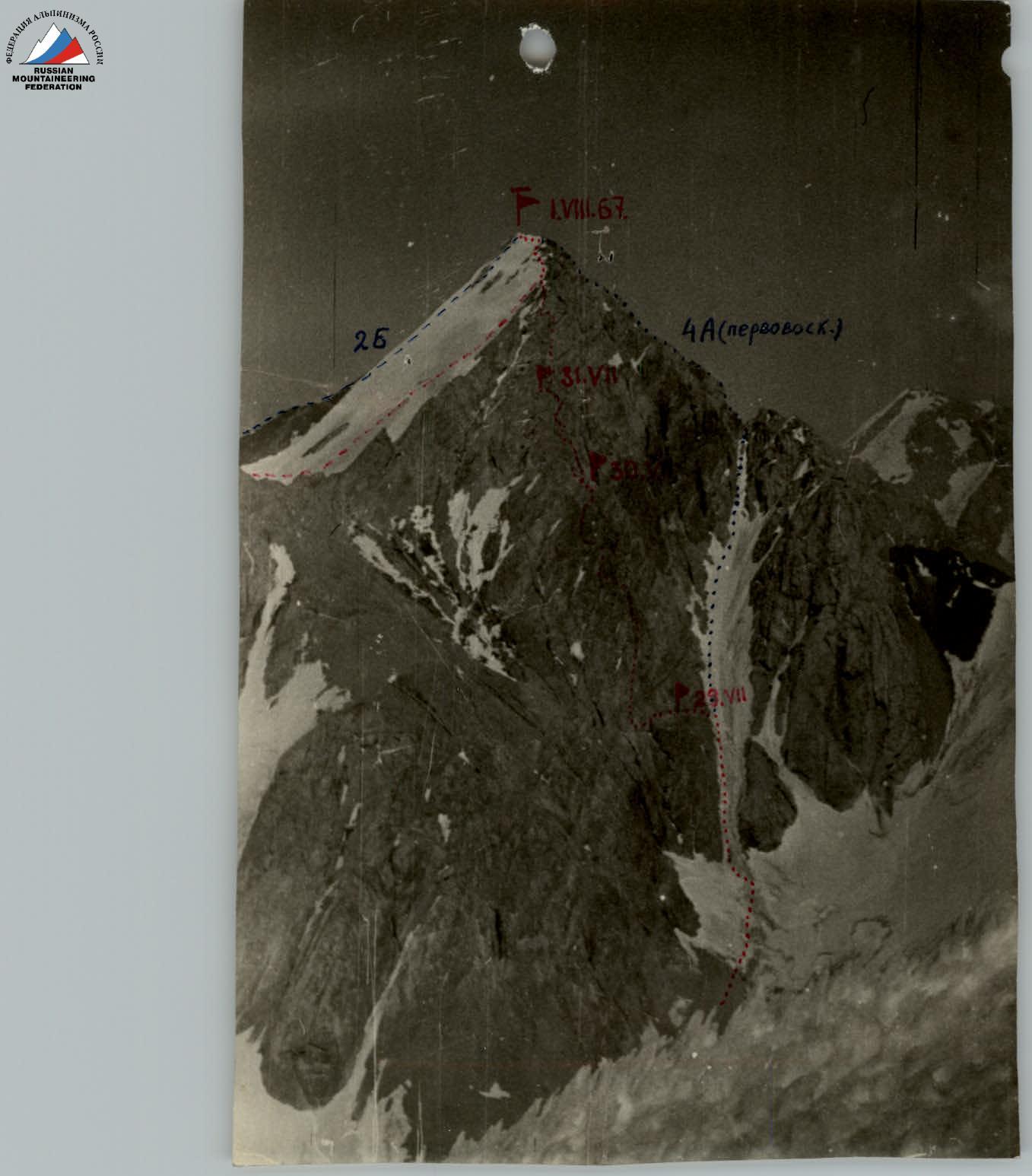
The western wall of Peak Energy is a rock massif bounded on the right by a wide snow-ice couloir. One can ascend to a saddle in the SW ridge leading to the summit via the right couloir (Category 4A route, first passed by the second Spartak team). On the left, several wide sheer cracks filled with accretion ice separate the wall massif from the NW ridge, also leading to the summit. The junction of the NW and W faces of the massif forms a giant outer corner, and the route was planned along the outermost part of this corner. To the right and left of the planned path stand sheer, partially overhanging smooth walls with almost no cracks. An exit to the ridge leading to the summit was visible in the upper part of the wall. Since the greatest difficulties were expected in the upper half of the route, it was decided to start the ascent without prior processing and, if necessary, to carry it out directly on the route from one of the assault camps. Reconnaissance showed that the first 200 m of height are gained via the right snow couloir, followed by a pure rock route. Only on the descent from the summit is snow encountered again. Therefore, it was decided to leave the boots with crampons with the observers after passing the couloir and to proceed in rubber-soled footwear, taking one pair of crampons for the descent. This saved about 20 kg of cargo for the group. Approximate bivouac locations were planned. The group expected to complete the route in 4–5 days. In fact, it took 3.5 days.
V. DESCRIPTION OF THE ROUTE AND ITS PASSAGE
On July 29, at 16:00, the Spartak team began its ascent from the assault camp (3800 m), located on a green meadow under Chimtarga Pass. The late departure from the camp was intentional, as the planned first night's bivouac at the beginning of the rock route was only a two-hour journey away. Additionally, unlike the Caucasus and Tian Shan, snow slopes like the one leading to the wall in the Fan Mountains are easier and safer to traverse in the second half of the day when the snow is softened by the sun. We exited onto the wall via a gentle open glacier and a horizontal lateral moraine. R1. Snow couloir with a slope of 30–35°. We ascended to a wide horizontal ledge, gaining approximately 200 m of height. The movement was simultaneous, without being roped together. R2 — horizontal rock ledge (100 m) leading to the NW face of the outer corner. The rock route begins here; it is also a convenient place for a night's bivouac (Camp I): a flat and protected from rocks area, with water available. The first control cairn was built on the site. July 30. We departed at 9:50. The ledge ends with steep slabs rising upwards. It is about 150 m from this point to Camp I. R3. Difficult slabs with a slope of 45°. On the left, they are bounded by an almost sheer wall. At the junction of the wall and the slabs, there is a narrow crack filled with snow and ice. Initially, we had to go to the right of it along smoothed slabs. The holds are no more than 1 cm. Such sections can only be passed in rubber-soled footwear. In the middle of the smoothed front, at the point where it becomes less steep, there is a large transverse crack. There, reliable insurance is organized through pitons. The next 50 m are passed with free climbing on rocks of medium difficulty — first along slabs and then along a semblance of a ridge bounding the crack on the right. Insurance is through pitons and выступs on the ridge. The length of R3 is 90 m, with 4 pitons driven. R4. The ridge ends with a sheer wall, at the base of which are several rock выступs. Using their holds for hands, we traverse (10 m) left along the path to the beginning of an almost vertical chimney. The chimney is very difficult, especially its lower part:
- The right lateral wall is completely smooth and sheer.
- The left wall is somewhat more sloping, with small holds. One has to climb using maximum friction. There are very few cracks for pitons: only 5 pitons can be driven in 30 m. In the upper third of the chimney, its inner part is filled with accretion ice, so one has to climb, bracing hands and feet against the rock walls of the chimney and leaning outwards. R5. The chimney ends — we emerge onto slabs with a slope of 30°. Climbing is not very difficult, but the remaining section of sheer rocks below and loose rocks ahead make one proceed with utmost attention and caution. At 40 m, 2 pitons are driven. Upper insurance is organized on a wide talus plateau — a saddle from which one can see the right, western face of the outer corner. R6. Further movement (120 m, 10 pitons) proceeds along a semblance of a buttress bounded on the left and right by rock sheers of the «faces» of the outer corner. The rocks here are of varying difficulty — sections of dissected rocks with a slope of about 30° alternate with short sheer walls (from 5 to 10 m). There are three such walls. The last one (10 m) is particularly difficult. The holds on it are very small, almost at the limit for free climbing. R7. The rocks on the next 80 m are of the same character. A section of sheer rocks leads to a ridge, separated from the main wall massif by a deep crack. These traverse the wall from left to right upwards. Such «diagonal» steep cracks are characteristic of the entire route. (See R3, R4, R5, R12, and R13). The ridge has a slope of about 60°. The rocks here are smoothed, with few cracks for pitons. A total of 7 pitons are driven on this section. Along the ridge, we approach the point where the crack is sealed by a vertical rock wall. R8. We traverse (5 m) along the ice under the base of the wall to the entrance to the chimney. This second chimney is even more complex than the first. Sometimes one can proceed only by wedging boot toes and using friction against the chimney walls. There are few cracks. Inside the chimney, there is ice. The upper part is blocked by a large stone plug, which can be bypassed on the left by leaning out of the chimney. On the 35-m chimney, 6 pitons are driven. For the first time, an 8-meter ladder was used here to facilitate the movement of participants with backpacks. R9. After passing the chimney, we find ourselves on a ledge from which a ridge of broken rocks (80 m, 2 pitons) extends left towards the wall massif, repeating the direction of the buttress R6. The slope of the section is about 30°. The ridge leads to a completely sheer wall. On the right, far below, is the couloir we ascended on the first day. On the left, the beginning of a wide crack extending upwards is visible. Apparently, the only possible path is there, but that's for tomorrow. On a tiny talus saddle between the wall and a characteristic, well-visible rock «red head» to the right of the ridge, we build a platform for a tent. This is Camp II. At 21:00, we establish light signal contact with the observers. We have covered 485 m during the day. Sections R3–R7 were led by V. Men'shikov, and section R8 by O. Grebennik. July 31. The bivouac was very comfortable. We rested well. On the «red head», we built the second control cairn. We departed at 10:00. R10. The vertical, partially overhanging smooth wall we faced yesterday offered no hope. So, we moved left. From the bivouac site, we ascended (10 m) left upwards along a sheer wall with very small holds to a platform at the beginning of a wide crack. On the left, far below, is the beginning of the route and the glacier. The crack has a slope of 80–90°. местами натёчный лёд. The rocks are smoothed; climbing is very difficult. As if «to order», after 40 m, there is a tiny ledge on the left where two people can stand. However, there is no room left for backpacks — we hang them on pitons. On this ledge, we organize a «relay», and another 40 m up the crack, which gradually narrows to the width of a chimney. On this section, 15 pitons are driven. V. Men'shikov led here. R11. The next section, and the one following it, is the key part of the entire route, technically extremely complex and psychologically very tense. Along the crack, we emerge onto a sloping platform. Its size is approximately 2 × 3 m. On two sides, sheer walls drop down; on the third side is the crack we ascended, and the fourth side adjoins a smooth, almost crack-free rock wall rising vertically. An exception is a small выступ of broken limestone clinging to the wall a few meters above the platform — it doesn't change the situation. The solution is a horizontal ledge visible 20 m above the platform, but the rocks below are sheer and smooth. So, expansion bolts! Having driven 2 rock pitons on the first three meters and standing on the выступ, one expansion bolt, Valery Men'shikov yields to Oleg Grebennik. Having hung for 1 hour 40 minutes on two-tiered ladders and driven 3 expansion bolts, 2 duralumin wedges, and 2 horizontal pitons, he reaches the ledge. The rock pitons and wedges had to be driven into a crack under a small rock canopy, so the piton body took a vertical position (eye down). Nevertheless, the pitons hold reliably. Upon reaching the ledge, Oleg drives two pitons there — «relay» — secures the rope and returns down. He is replaced again by Valery. To our regret, upon closer inspection, the ledge turns out to be a small niche where one can stand only by pressing against the wall (and without a backpack!). Further along the wall, there are several rock выступs that can be used as good footholds for free climbing. Sometimes one has to simply hang on hands. While traversing, Men'shikov drives another 3 pitons through which he is «released» by I. Meshkov, who climbed up to the niche for this purpose. A total of 11 regular and 4 expansion bolts are driven on this section. The full length of the section — from the platform to the exit into the corner — is 40 m, which is traversed: first straight up (25 m), then traversed left (15 m). By traversing the wall left, one can exit to an inclined inner corner, climbing from выступ to выступ. This «acrobatics» has to be done over a half-kilometer sheer drop. The latter circumstance is significantly disciplining. R12. This corner has a slope of 60–70°; its left side is vertical, and the right side is a semblance of a ledge with an outward slope of about 30° (i.e., the cross-section of this dihedral angle is 120°). The corner leads to the upper part of the smooth wall starting from Camp II. Climbing the corner remains extremely difficult: the holds are very small; one has to rely on friction and bracing, occasionally using a wide crack in the corner's depth for insurance with wide duralumin wedges. After 20 m, V. Men'shikov lets I. Meshkov lead. The complexity of the section gradually increases: the right edge of the corner («ledge»), 2 m wide at the start, gradually narrows to 40 cm, so one has to walk along the very edge of the sheer drop, with the pleasant possibility of seeing the glacier directly below. After 30 m from the entrance to the corner, a wide groove extends upwards along the left wall. Further movement along the corner becomes meaningless: its right side — the «ledge» — tapering to nothing, leads to a sheer deep wall. The only path is an ascent along the groove. Although it appears feasible, entering the groove is not straightforward. To do this, one has to overcome a one-and-a-half-meter overhanging wall without suitable выступs for support or piton placement. Having driven 2 ice screws and 1 rock piton into the rocks and using one of the first as a support, I. Meshkov enters the groove and then, having climbed another 10 m of difficult rocks, finds a narrow ledge and a tiny 1 × 1.5 m sloping platform under the sheer wall. Thus, the second half of the key section is passed. On 40 m, 12 pitons are driven (including 2 ice screws and 4 wedges). Due to the late hour, we have to settle for a sitting bivouac: it's already 19:00, and it takes another 1.5 hours for the lower three to pull the backpacks up the wall. (To speed up, we used an 8-meter ladder again. It turned out to be more convenient to drop it directly from the entrance to the corner to the platform under the wall.) August 1. We spent the night tolerably. Nevertheless, the lack of comfort predetermined an early departure. At 8:00, Oleg Grebennik started the first meters of the last day's ascent. R13. From the bivouac site, the NW ridge is well visible, separated from the wall by a wide and very steep couloir with accretion ice. To the left of the ledge where we bivouacked, and 2 m higher, a second inclined ledge extends from left to right and upwards, similar to yesterday's corner but somewhat easier. On this ledge, one must be extremely attentive and thoroughly check the rock sections because the rocks here are broken, and their solidity is deceptive. It leads, after 40 m of difficult but calm climbing (5 pitons), to a wide platform. Here, we establish the III control cairn. This is approximately the height of Zindon peak (about 4800 m). Here, one can more comfortably organize a sitting bivouac (there's still no space for a tent). R14. From here, we proceed along not very difficult broken rocks (120 m, 4 pitons, выступы) to a «window» in the sheer rocks forming the NW ridge. A platform under a 4-meter wall with overhanging rocks. Oleg Grebennik, using Valery Men'shikov's back, shoulders, and then head, emerges above the wall. Further — 30 m of rocks of medium difficulty (45°, two pitons, insurance through выступы), and we are on the ridge, or rather on its left side. The negative wall was passed by two using the «support» of the next comrade, and for the last one, we dropped an 8-meter ladder. R15. 120 m of rocks of medium difficulty (6 pitons) along the ridge and to the left of it. In a comfortable snow mulde, enjoying the warmth of the generous Fan Mountains sun, we have a «second breakfast». This is perhaps the first suitable place for a bivouac after Camp II. R16. From the mulde, we proceed 40 m along rocks of medium difficulty, then traverse left (80 m) along gentle snow to the ridge bounding the preliminary snow fields on the right. Ahead is a straightforward path to the summit. The height gain is about 200 m at a slope of 30°. We leave our backpacks and, via easy rocks and partly snow (here Sergey Andreev leads, wearing crampons because there's ice under the snow), reach the summit in 30 minutes. The total length of the section is 400 m, with one ice piton driven. 14:00. From the cairn, we retrieve a note from our second group, which successfully completed their route yesterday. The guys left us chocolate, a liter jar of «kuk-cha», and warm congratulations. After 30 minutes of bliss under the boundless Pamir sky, we begin our descent. Initially, we descend simultaneously along the ascent route to our backpacks. From here, we exit onto the snow fields and, using rappel (the last one with crampons and lower insurance through an ice piton), descend (240 m, slope 30–35°) onto gentle snow fields under the Chimtarga Pass. On the last rope, we have to cross a bergschrund. On the left side, where we descend, it is not wide and can be easily jumped over. We exit onto the moraine along the snow and, after 30 minutes of very pleasant descent, arrive at the assault camp on the green meadow. The ascent is complete. We dismantle the assault camp and arrive at the base camp on Lake Allo by 21:00.
VI. CONCLUSION ON THE ROUTE'S DIFFICULTY
The total length of the route covered is approximately 1900 m with a height difference of about 1100 m. Of these, the length of the most difficult sections of the route is about 400 m at an average slope of 80°. 94 rock pitons were driven on the route, including 28 duralumin wedges, 4 expansion bolts, and 3 ice screws (2 of which were into rocks). In our opinion, the route passed is a very strong Category 5B, of a modern type, if one can say so. The route requires the use of all means in the arsenal of rock climbing techniques: climbing using artificial footholds (piton, ladders, etc.), expansion bolts, wide duralumin wedges, etc. Comparing this route with those passed earlier, we can say that it is significantly more complex than Pelevin's route on Main Talgar (Category 5B difficulty) and the Category 5B wall route on Peak «Trud» (4600 m) in Talgar.
VII. STYLE OF ASCENT
When approaching the route, three backpacks were taken per team, allowing the first to proceed with minimal load. The excellent grip of rubber soles on the rocks enabled reliable passage of very difficult sections, and although the route is characterized by a lack of cracks in the rock, which resulted in relatively few pitons being driven, this did not create a feeling of insecurity. The «three-rope tactic» we applied significantly increased the team's speed. Let's clarify immediately that it has nothing in common with a «convoy» or «locomotive». Its essence is as follows:
- The first, having passed the next rope length, secures it to a piton for a fixed rope, along which the second, carrying a free third rope (the second rope is occupied by the second rope team), proceeds with a Prusik knot.
- Then the second, using the free rope and an unattached insurance point, lets the first lead (or proceeds himself).
- At this time, the second rope team independently follows along the fixed ropes left by the first team. There can be various variations of this method. The essence is that the teams advance simultaneously, as with independent rope team movement, and fixed ropes are used without having to pass a difficult section twice with lower insurance. The 8-meter ladder also contributed significantly to increasing the ascent rate. It should also be noted that during the ascent, the team worked in harmony, with complete mutual understanding, facilitated by three years of experience in joint ascents. We also note that the team was well-trained before heading into the mountains; participants had previously completed ascents of Category 4A+I and 5B+I difficulty.
VIII. TEAM EQUIPMENT
During the ascent, both standard factory-made equipment and self-made mountaineering equipment, widely used in recent years, were used. All self-made equipment intended to bear loads (piton, wedges, etc.) was tested for strength in the laboratory of p/o 82, Novosibirsk (test protocol is stored in the files of the Novosibirsk Regional Federation of Alpinism). The team had the following equipment on the route:
- 9 mm rope, 40 m — 3 pcs. (see §VII).
- Rock pitons (VCSPS) — 25 pcs. (preferably horizontal).
- Expansion bolts — 20 pcs. (4 used*). *) Expansion bolt heads made of KВК alloy were manufactured thanks to the assistance of Master of Sports A. Snesarev.
TABLE OF CHARACTERISTICS OF SECTIONS OF THE ASCENT ROUTE TO PEAK ENERGY VIA THE WESTERN WALL
Route length 1900 m, including the most difficult sections — 400 m. Height difference 1100 m. Average slope of the most difficult sections — 80°.
| Date | Section | Slope | Length along relief | Technical difficulty | Pitons |
|---|---|---|---|---|---|
| July 29, 1967 | R1 | 30–35° | 400 m, snow-ice couloir | easy | - |
| R2 | 0° | 100 m, rock ledge | easy | - | |
| R3 | 45° | 90 m, slabs | medium | 4 | |
| R4 | 80° | 40 m, chimney | very difficult | 5 | |
| R5 | 30° | 40 m, slabs | medium | 2 | |
| July 30, 1967 | R6 | 30° | 100 m, broken rocks | medium | 10 |
| R7 | 80° | 20 m, steep ridge | difficult | 7 | |
| R8 | 60–90° | 80 m, chimney | very difficult | 6 | |
| R9 | 30° | 80 m, ridge | medium | 2 | |
| July 31, 1967 | R10 | 90° | 10 m, wall | very difficult | 15 |
| R11 | 80° | 80 m, wide crack | difficult | (2 rock, 4 expansion) | |
| R12 | 90° | 25 m, wall | very difficult | (10 rock, 2 expansion) | |
| 15 m, rock ledges | difficult | ||||
| 60–80° | 30 m, inner corner | very difficult | |||
| 10 m, wall | very difficult | ||||
| August 1, 1967 | R13 | 60° | 40 m, inclined ledge, crack | very difficult | 5 |
| R14 | 30° | 120 m, broken rocks | medium | 4 | |
| R15 | 90° | 4 m, wall | difficult | ||
| R16 | 45° | 120 m, slabs | medium | 6 | |
| 30° | 500 m, ridge | easy | 1 ice |
Total: 94 pitons
Team Captain: V. Men'shikov Team Coach: V. Martynov
CONDITIONS, WEATHER, DAILY RATIONS
July 29, 1967: Departure — 16:00 in tent-bivouac — 18:00. Ascent — 200 g of provisions — 2 hours. Ascent along the slope:
- First — free climbing.
- Others — via fixed ropes. Rope teams work independently (see «Style of Ascent» section). Insurance:
- Through pitons.
- On sections of medium difficulty rocks — through выступы. In the chimney (R8), an 8-meter ladder was used.
July 30, 1967: Departure — 9:50. Bivouac — 18:00 in a tent on a talus saddle, sun, 800 g of provisions — 8 hours. Same as before; in the crack, an 8-meter ladder was used.
July 31, 1967: Departure — 10:00. Bivouac — 20:30. Sunrise — 10:30. Ascent:
- First — on two-tier ladders.
- Others — via 8-meter ladder. Insurance — piton.
August 1, 1967: Departure — 8:00. At the summit — 14:00. Return to base camp — 21:00. Ascent along the slope:
- First — free climbing.
- Others — via fixed ropes. Insurance — piton.