Ascent Passport
- Ascent class — technically challenging.
- Ascent area — Fann Mountains.
- Ascent route, peak, its height — p. Energiya, 5100 m, Northeast wall.
- Estimated difficulty category — 5B.
- Route characteristics: height difference — 1100 m. route length — 4450 m. length of 5th difficulty category sections — 770 m. average steepness — 65–70°
- Pitons hammered: rock — 80, chocks — 2, ice — 1 (on descent).
- Number of climbing hours — 49.
- Number of overnight stays and their characteristics: one overnight stay, lying down.
- Team name — LGS DSO "SPARTAK".
- Surname I.O. of the leader, participants and their qualification: NEPLOKHOV ANDREY DANITRIEVICH — 1st sports category — leader ROMANOV EVGENY VASILYEVICH — 1st sports category NOZLOVSKY VICTOR IOSIFOVICH — 1st sports category MAKSIMOVA ANTONINA GRIGORYEVNA — 1st sports category.
- Team coaches: NOLCHIN ALEXANDER ALEXANDROVICH — Master of Sports of International Class NOVGORODTSEVA GALINA PETROVNA — 4th sports category.
- Ascent time — August 1, 1979 – August 2, 1979.
| Date | Section | Steepness (°) | Length (m) | Terrain characteristics | Difficulty | Condition | Weather conditions | Rock pitons | Chock pitons | Ice pitons | Passage, length | Departure and stop times for bivouacs, climbing hours, overnight stay conditions |
|---|---|---|---|---|---|---|---|---|---|---|---|---|
| August 1, 1979 | R0–R1 | 40 | 100 | snow slope | 3 | monolithic with small footholds, snow | good | — | — | — | alternating movement | 8:00 — start of work on the route |
| R1–R2 | 55 | 100 | smoothed wet "ram's foreheads" | 5 | monolithic with small footholds | good | 6 | — | — | free climbing first 20 m without a backpack, 40 m with ropes | — | |
| R2–R3 | 70–75 | 160 | smooth slabs with cracks and good footholds, stone-hazardous inner corner | 5 | smooth slabs with cracks and good footholds, stone hazard! | good | 15 | — | — | alternating movement | — | |
| R3–R4 | 50 | 60 | inner corner | 4 | slabs with good footholds | good | 3 | — | — | alternating movement | — | |
| R4–R5 | 65 | 120 | wall | 5 | good smooth slabs with a small number of cracks and footholds | good | 8 | — | — | alternating movement | — | |
| R5–R6 | 50 | 80 | "ram's foreheads" | 5 | monolithic with a small number of footholds, wet | good | 5 | — | — | alternating movement | — | |
| R6–R7 | 45 | 120 | ledges | 3 | monolithic with ledges | good | 4 | — | — | alternating movement, many ledges for belay | — | |
| R7–R8 | 40 | 60 | chimney | 4 | monolithic with good footholds | good | 3 | 1 | — | alternating movement | — | |
| R8–R9 | 60 | 30 | inclined slab | 5 | monolithic without cracks with small footholds | good | 2 | — | — | alternating movement | — | |
| R9–R10 | 50 | 20 | slab, inner corner with overhang, slab | 5 | smooth slab with a wide crack, monolithic with small footholds | good | 6 | — | — | alternating movement, first without a backpack | overnight stay on a ledge under an overhanging rock, lying down, snow is present. The group stopped for the night at 21:30. | |
| August 2, 1979 | R10–R11 | 40 | 60 | inner corner with an overhanging plug in the middle, stone-hazardous! | 5 | wet monolithic with small footholds | good | 6 | 1 | — | movement along the ropes, first 20 m without a backpack | departure from the overnight stay at 8:30 |
| R11–R12 | 45 | 140 | inner corner | 4 | monolithic | good | 11 | — | — | alternating movement | — | |
| R12–R13 | 60 | 100 | inner corner | 5 | "tiles" and monolithic with small footholds | good | 6 | — | — | alternating movement | — | |
| R13–R14 | 70 | 80 | couloir with an overhanging plug in the middle | 5 | monolithic with small footholds | good | 5 | — | — | alternating movement | — | |
| R14–R15 | 20 | 500 | destroyed ridge with snowfields | 3 | destroyed rocks | cloudy | — | — | — | alternating and simultaneous movement with belay through ledges | return to the original bivouac on the glacier moraine at 18:30. |
Brief explanation for the table
From Alaudin lakes along the trail to Mутные lakes — 2 h 30 min, bypassing the lake on the right. Ascent to the glacier under the Eastern ridge and along the glacier to the Northeast wall of the peak — 2 h 30 min. Here, overnight stays in the upper part of the medial moraine on convenient platforms. (A convenient place to observe the route). The start of the route is along the bastion, to the right of which there is a large snowfield crossed by a bergschrund. From the overnight stay, ascend along the snow to the right end of the bergschrund.
- R0–R1. From the bergschrund — traverse left-up along the snow slope to a snow triangle protruding into the bastion rocks, and from it transition to the rocks.
- R1–R2. Straight up along the wet "ram's foreheads" (first without a backpack), with small footholds to a 2.5 rope ledge. Control Point No.1 (CP-1). From the exit to the rocks — 2 h 30 min.
- R2–R3. Along the ledge to the left — exit to an inner corner (stones from above!), transition to its left wall, then straight up 160 m to a wide rock ledge. From CP-1 — 3 h.
- R3–R4. Exit from the inner corner — up-right. Easy climbing — 1.5 ropes.
- R4–R5. Straight up along smoothed rocks with a small number of footholds and cracks for belay 3 ropes. Exit to an osypnaya ledge at the top of the bastion. From CP-1 — 5 h.
- R5–R6. Along the right side of the couloir with a stream 20 m up-left under an overhanging wall (60 m), exit to its top along wet smoothed "ram's foreheads" with a small number of footholds and cracks for belay.
- R6–R7. Parallel to the couloir with a stream along ledges (120 m), exit to a chimney going up-left.
- R7–R8. Along the chimney — 60 m, climbing of medium difficulty, under a smooth inclined slab.
- R8–R9. Left-up along a smooth slab without cracks and with small footholds — 30 m.
- R9–R10. Traverse right onto a wet slab under an overhanging wall. A wide longitudinal crack runs along the slab, along it — 20 m to a vertical inner corner with an overhang in the upper part (10 m). Exit to a rock ledge under the overhanging wall. The first person climbs this rope without a backpack. On the ledge — a convenient and safe overnight stay with water. Control Point No.2 (CP-2). From the top of the rock bastion to CP-2 — 5 h 30 min.
- R10–R11. From CP-2 — along the inner corner with an overhanging plug in the middle part, exit under the overhanging wall (first without a backpack). Bypass to the right — along a wet slab along a snowy couloir (stone-hazardous). From CP-2 — 60 m.
- R11–R12. Crossing the couloir along the snow, exit right-up along the inner corner to a platform in a niche (40 m), and further left-up along the inner corner to a couloir with a snowfield — 100 m.
- R12–R13. Crossing the snowfield to the right, exit under the inner corner. Further up along the inner corner, exit to the lower part of the couloir leading to the Eastern ridge — 100 m.
- R13–R14. Along the couloir — under an overhanging plug in its middle part, bypassing it on the left along a chimney with an overhang, transition to the left side of the couloir (stone-hazardous). Exit to the Eastern ridge — 80 m. From CP-2 — 5–6 h.
- R14–R15. Ascent along the Eastern ridge to the summit — 400 m (1–1.5 h).
Descent description
Descent from the summit along the Northern ridge (2A category difficulty) to the Chimtorga pass:
- first along osypny ledges,
- then along ice covered with a thin layer of snow. Further along osypny ledges to the original bivouac — 1.5–2 h.
Route recommendations
It is recommended to start the route at 5:00 AM, so that by 6:00 AM to begin work on the rocks, as from 0:00 to 12:00 the right part of the bastion is exposed to ice and small stones. On the entire bastion (section R1–R5) there are safe places for organizing belay, safe from stones, and it is recommended to choose exactly those.
For an overnight stay, it is recommended to stop on the ledge where CP-2 is located, as this is the most convenient and safest place for an overnight stay along the entire route to the Eastern ridge.
The route is well-suited for pairs, as it is convenient for observation. The group does not recommend going on the route with more than 4 people.
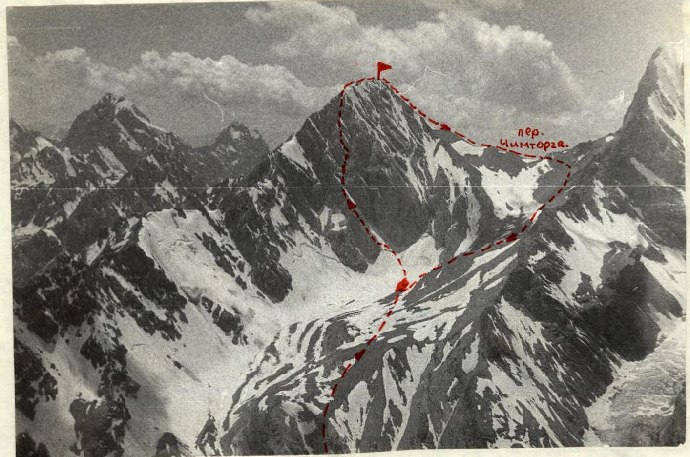 Peak Energiya, its Northeast wall, Eastern ridge and Chimtorga pass.
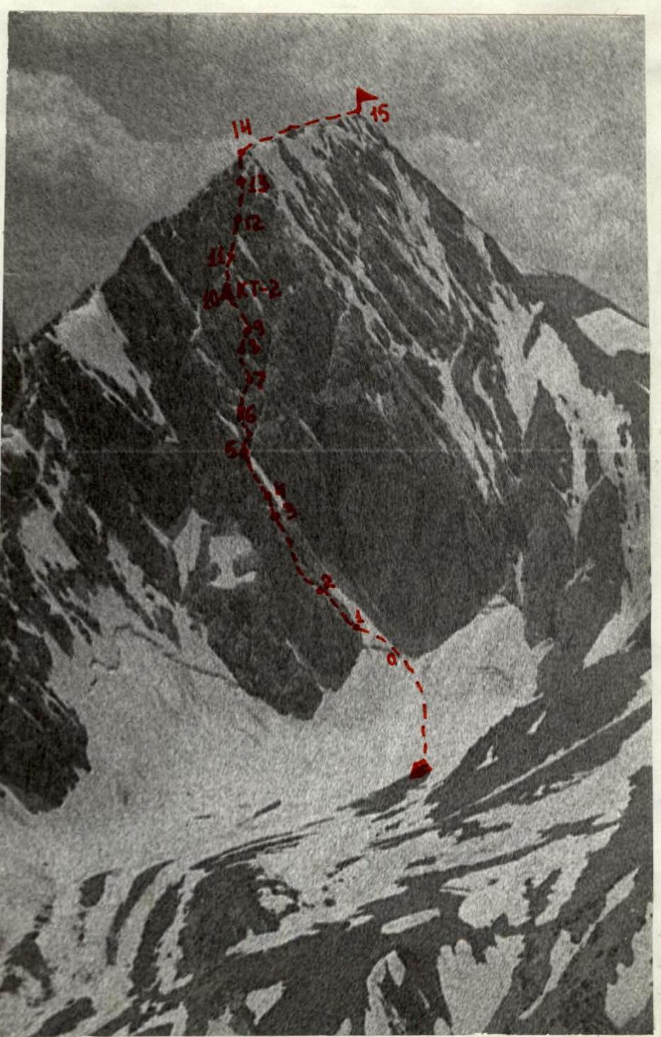 Profile of the bastion (R1–R5) and en face view of the upper part of the wall (R5–R15).
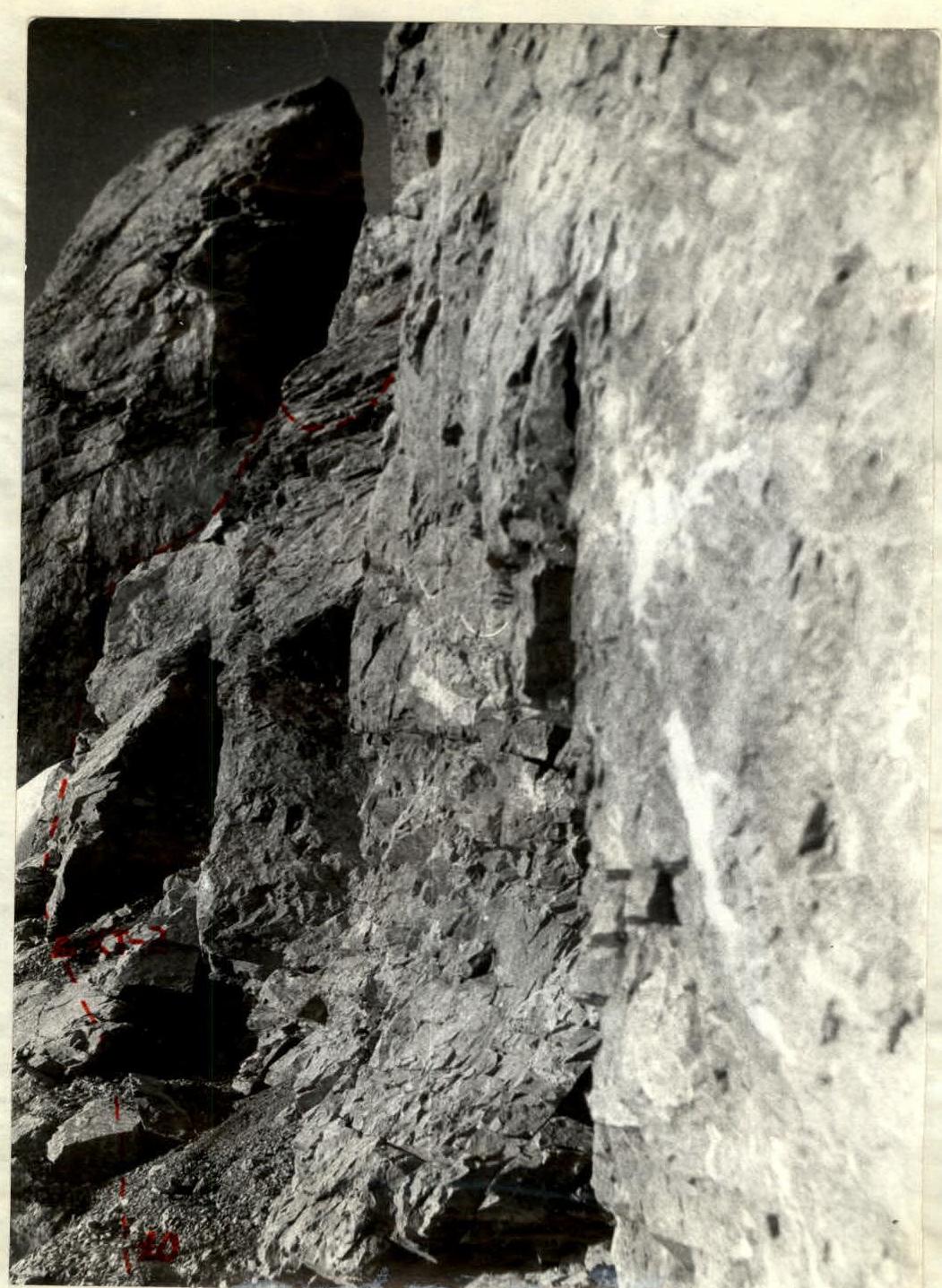
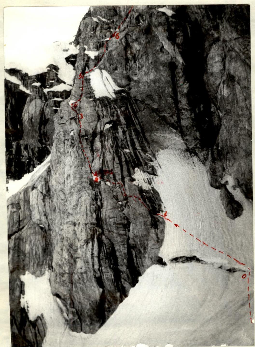 En face view of the bastion — sections R1–R5.
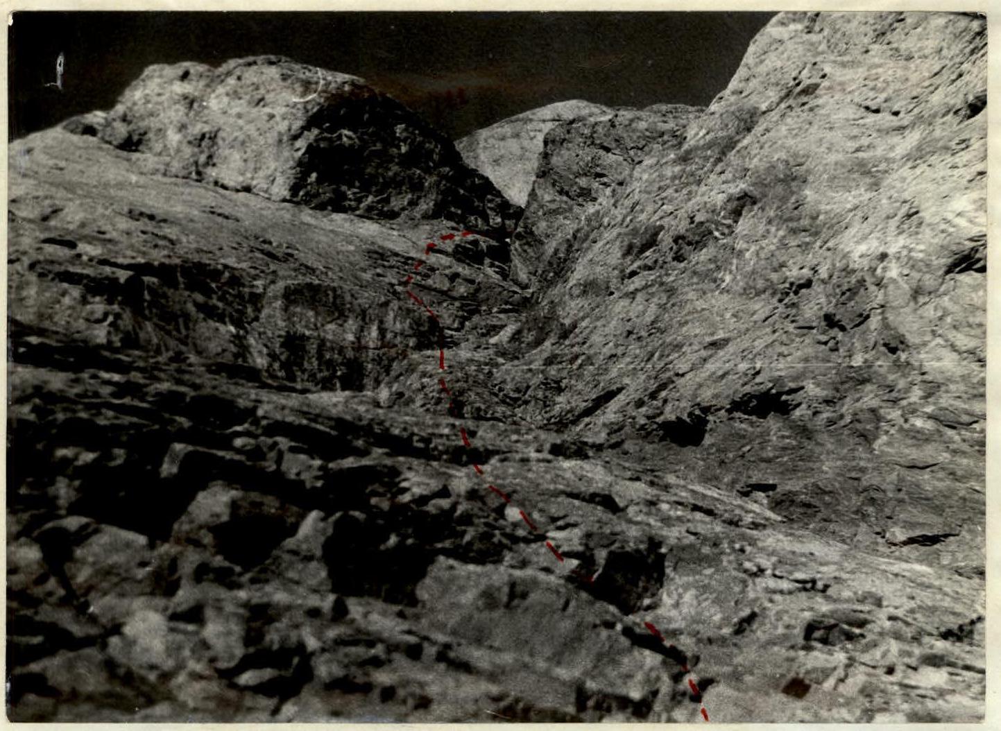
 Profile of the upper part of the wall — sections R5–R14. Sections R6–R10 are obscured by an overlapping ridge.
 Continuation of the route from the upper part of the bastion (section R5–R6).
 Continuation of the route from the overnight stay (approach to the plug in the inner corner).
 Inner corner — section R10–R11. The photo is taken from under the overhanging plug.