- Class of ascent: technical.
- Area of ascent: Fan Mountains.
- Peak, ascent route: p. "Energiya" (5105 m), via the eastern ridge.
- Estimated difficulty category: 4A.
- Characteristics of the route.
Height difference: 1063 m. Length of sections with 5th category difficulty: 55 m. Total length of the ridge horizontally: 2800 m. The route consists of three sections of varying difficulty: a) ridge 2–3 cat. diff. — average steepness 10°, horizontal length 1900 m; b) ascent 4–5 cat. diff. — average steepness 50°, horizontal length 500 m; c) pre-summit ridge 3 cat. diff. — average steepness 30°, horizontal length 400 m.
- 26 rock pitons were hammered on the route, 20 chocks were used — all for belays.
- Number of travel hours: 17.
- One overnight stay on the route. Convenient site on the first shoulder of the peak (height approximately 4500 m). Not prone to rockfall. No water. Snow and ice are present.
- Group composition.
Simonova Vera Nikolaevna (II sports category) — leader, Laletin Andrey Vladimirovich (I sports category) — participant, Shustrov Nikolay Borisovich (I sports category) — participant, Stroganov Yuriy Vladimirovich (I sports category) — participant.
- Team coach: Master of Sports of International Class Kolchin Alexander Alexandrovich.
- Date of departure on the route: July 10, 1979.
Date of return: July 11, 1979.
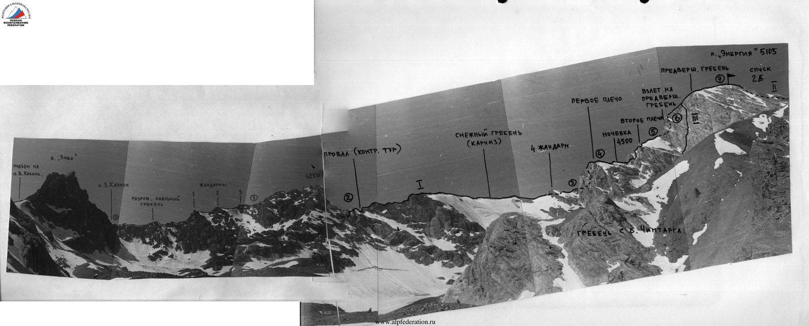
 Peak "Energiya" (5105 m)
I — route of the first ascent via the eastern ridge (approximately 4A category); II — route 2B category from Chimtarga pass (descent route); III — upper part of the route of the first ascent approximately 5B category via the north-eastern wall, climbed by a group of mountaineers under the guidance of A. D. Neplokhov in the 1979 season.
Photograph of the eastern ridge of peak "Energiya"
I — route of the first ascent via the eastern ridge (approximately 4A category); II — route 2B category from Chimtarga pass (descent route); III — upper part of the route of the first ascent approximately 5B category via the north-eastern wall, climbed by a group of mountaineers under the guidance of A. D. Neplokhov in the 1979 season.
Table of main characteristics of the ascent route.
| Characteristic of the section | Terrain characteristics | Condition | Weather conditions | Pitons, chocks | Notes | |||||||
|---|---|---|---|---|---|---|---|---|---|---|---|---|
| 1 | 2 | 3 | 4 | 5 | 6 | 7 | 8 | 9 | 10 | 11 | 12 | 13 |
| 10.07.1979 | R0–R1 | 15 | 600 | ridge | 2 | heavily fragmented | clear, light cloud cover, strong wind | - | - | - | 3 | simultaneous movement |
| --n-- | R1–R2 | 0 | 500 | traverse of "ram's foreheads" | 3 | monolithic | --n-- | 3 | - | - | 2 | |
| --n-- | R2–R3 | 15 | 800 | snow-rock ridge | 3 | fragmented | --n-- | - | - | - | 4 | |
| --n-- | R3–R4 | 35 | 300 | rock-ice ridge | 4 | --n-- | --n-- | 7 | - | - | 3 | |
| 11.07.1979 | R4–R5 | 70 | 200 | ridge; wall | 4 | --n-- | --n-- | 8 | - | - | 5 | |
| --n-- | R5–R6 | 60 | 250 | walls with large ledges | 4 | heavily fragm., rockfall hazard | --n-- | 8 | - | - | 3 | key location |
| --n-- | R6–R7 | 30 | 500 | rock-snow ridge | 3 | fragmented | --n-- | - | - | - | - | simultaneous movement |

Brief description of approaches
From the "Artuch" tourist base, move up along the trail to Kulikalon lakes (2800 m), then through Alaudin pass (3730 m) — to Alaudin lakes (2700 m), and then up the valley to Mutnye lakes (3490 m), where the initial bivouac is organized.
Ascent from Mutnye lakes along the left part of the moraine in the direction of Zmeya peak. Then left upwards, bypassing Zmeya peak on the left, exit to Eastern Kaznok pass (4040 m).
From here, traverse along the talus slope on the other side of the peak to Western Kaznok pass (4050 m). 2 hours 30 minutes from Mutnye lakes. Start of the route.
Exit to Western Kaznok pass directly from the Mutnye lakes cirque is not always possible, as there may be ice on its northern slopes and a snow cornice in the upper part.
Description of the route
Section R0–R1
Move along the simple, heavily fragmented ridge in the direction of the 4250 m mark. Movement is mostly simultaneous. Most obstacles, as well as "gendarme" 1 and 3 are bypassed on the left. "Gendarme" 2 is climbed directly. If necessary, alternate movement — belay via slings and chocks. 3 chocks used. Overall category of difficulty of the section: 2.
Section R1–R2
Beyond the 4250 m mark, there is a gap in the ridge, so reaching it is not mandatory. It is possible to traverse the ridge with a slight loss of height on the left along a system of ledges, representing non-steep "ram's foreheads" dropping off to the south with walls. Reliable belay is necessary. Slings, chocks, pitons. The traverse is about 300 m long and leads slightly below the gap.
Ascent to the ridge along snow and then along a rocky ridge crest into the gap. In the gap — an intermediate control cairn. Used: — 3 rock pitons, — 2 chocks.
Overall category of difficulty of the section: 3.
Section R2–R3
From the gap, left upwards — exit to the left side of the ridge. Movement along scree ledges followed by an exit to the ridge. Further along the scree and snow ridge (cornices!) — simultaneous movement towards the fourth "gendarme", which is bypassed on the left along scree and rocky ledges. Alternate belay. Then — exit to the ridge under the first shoulder of the peak. Here, for the first time on the route, water is encountered. 4 chocks used. Overall category of difficulty of the section: 3.
Section R3–R4
The ascent to the first shoulder of the peak begins along a wide chimney with an exit in its upper part to the left (20 m, pitons). Then traverse the shoulder on the left with a gradual gain in height: — first along non-steep slabs, — then along snow, — finally along a scree ledge and a wide scree couloir leading to the first step of the shoulder.
From here, right upwards along the ridge along the boundary of rocks and ice — exit to the second step of the shoulder (60 m, piton belay). Further is a snow-rock ridge crest abutting powerful walls of the second shoulder of the peak. Approximately in the middle of the ridge crest, there is a convenient overnight site, located 20 m below the ridge on its southern slope. No water, but snow and ice are present. From the start of the route — 9–10 hours. 7 rock pitons hammered, 4 chocks used. Overall category of difficulty of the section: 4.
Section R4–R5
The wall of the second shoulder of the peak is cut by a wide rock-snow couloir, to the right of which is a yellow rocky massif, representing a ridge in the lower part and a gradually flattening wall — in the upper part.
Move upwards, traversing the yellow ridge on the left along a narrow rocky ledge (40 m, pitons), and then along scree ledges and snow under the wall to the right of the couloir. Climb the wall directly (35 m, category of difficulty of the section: 5), and then along steep rocky ledges (80 m, slings, chocks, pitons) upwards to a small ridge shoulder, from which right upwards to the ridge along simple fragmented rocks.
Along the ridge, exit to snow (40 m), steep in the upper part, and along it approach the ascent to the pre-summit ridge.
8 rock pitons hammered, 5 chocks used. Overall category of difficulty of the section: 4.
Section R5–R6
The ascent is a steep rocky bastion with a wide "chimney" in the middle part. Move upwards 20 m to the right of the "chimney" along heavily fragmented rocks. Then traverse left, crossing the "chimney", to a scree platform, and from it through an overhanging internal angle (4 m) left behind the angle of the bastion. Further traverse 30 m, and then right upwards along steep, heavily fragmented rocks with ice (20 m, category of difficulty of the section: 5) to wide inclined ledges with scree.
Up to this point, when passing the ascent, reliable alternate belay is mandatory. Use: — slings, — chocks, — pitons.
Pay special attention to rockfall hazard. Further along scree ledges — simultaneous movement towards a wide couloir with snow, and along it right upwards (150 m) — exit to the pre-summit ridge.
8 rock pitons hammered, 3 chocks used. Overall category of difficulty of the section: 4.
Section R6–R7
The pre-summit ridge is non-steep, with a highly dissected relief. Movement is mostly simultaneous. On snowy sections — cornices. Overall category of difficulty of the section: 3. From the overnight site on the first shoulder to the summit (5113 m) — 6–7 hours.
Descent from the summit to Chimtarga pass (4600 m) along a route of 2A category. The descent may be complicated by an ice section (up to 80 m) in the middle part. From the summit to the pass — 1 hour. From the pass to Mutnye lakes — 1.5 hours.